


























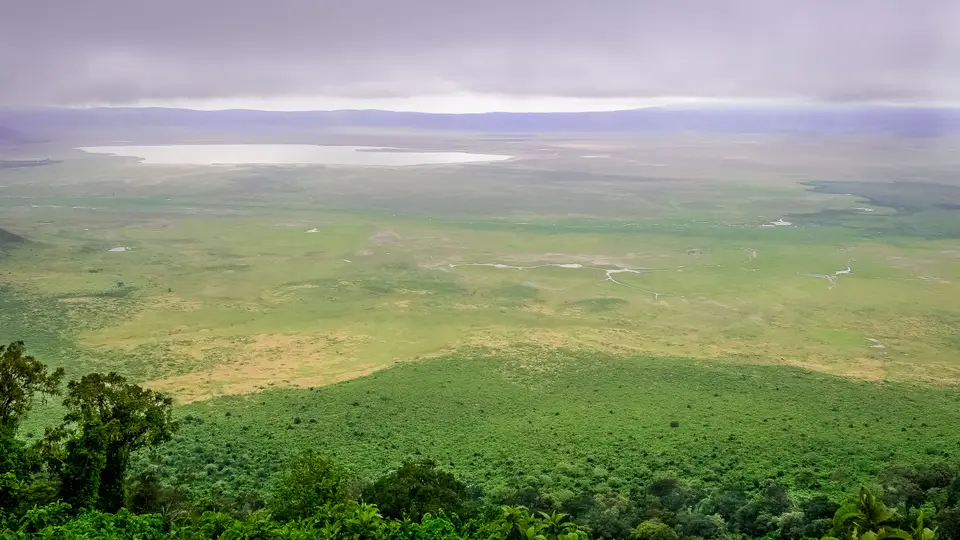
Quick Field Data
- UNESCO Inscription: 1979 · Criteria (iv), (vii), (viii), (ix), (x), extended to Mixed status in 2010
- Scale & Footprint: 809,440 hectares (with wider district surveys recording 8,292 square kilometres) including the 260-square-kilometre Ngorongoro Crater floor and the 50-kilometre Olduvai Gorge
- Access & Ticketing: Administered by the Ngorongoro Conservation Area Authority with per-vehicle entry and separate crater descent fees, plus a strict ceiling of 50 vehicles allowed inside the caldera at one time
- Arrival Logistics: Situated in Ngorongoro District within the Arusha Region, 180 kilometres west of Arusha City along the main highland corridor linking the Great Rift Valley to the Serengeti National Park
Pliocene Shield Volcanoes and Caldera Collapse
The Ngorongoro Conservation Area extends across 809,440 hectares of northeastern Tanzania, bridging the Great Rift Valley escarpments and the short-grass plains abutting the Serengeti National Park. Located 180 kilometres west of Arusha City in the Crater Highlands, the landscape was forged by the Pliocene Ngorongoro volcanic group inside the Eyasi half-graben. This tectonic depression is bounded on the east by the Gregory Rift Western Escarpment and on the southwest by the Lake Eyasi escarpment. Eight extinct shield volcanoes form the highland backbone: five rise as dome-shaped cones while three collapsed inward to leave deep calderas. Among them, the Ngorongoro Volcano was active between 2.45 and 2 million years ago, composed primarily of basaltic trachyandesite. When its magma chamber emptied, a cone originally estimated at 4,500 to 5,800 metres in elevation collapsed upon itself, leaving the largest unbroken and unflooded volcanic caldera in the world.
Today the floor of Ngorongoro Crater rests 1,800 metres above sea level, enclosed by sheer walls that drop 610 metres and encompass 260 square kilometres of open grassland, swamp, and woodland. The caldera is vast. Two smaller calderas, Olmoti (active 2.01 to 1.79 million years ago) and Empakaai, underwent similar magma-chamber collapses across the highlands alongside the cones of Loolmalasin, Sadiman (dating to 3.7 million years ago), Lemagrut, and Oldeani. To the northeast of the Empakaai caldera stand two younger volcanic peaks, Kerimasi and Ol Doinyo Lengai; the latter, whose Maasai name translates as Mountain of God, remains active and produced major ash and lava eruptions in 2007 and 2008. Farther northwest, the volcanic highlands give way to the Serengeti Plains, the Salei Plains, and the Gol Mountains inselbergs, where outcrops of Mozambique Belt quartzite and mica schist date back 800 to 500 million years.
Surface hydrology inside the main caldera creates a self-contained ecological basin that sustains year-round wildlife densities despite seasonal shifts. The Munge Stream drains Olmoti Crater from the north, delivering the primary freshwater inflow into the central alkaline depression known to the Maasai as Makat (meaning salt) and mapped as Lake Magadi, a shallow pan reaching 1.7 metres in depth. From the humid montane forests on the southern rim, the Lerai Stream descends to nourish the yellow-barked acacias of the Lerai Forest before spilling into Lake Magadi during heavy rains, though water extraction by rim lodges and Ngorongoro Conservation Area headquarters reduces inflow into Lerai by around 25 percent. Along the eastern crater wall, the Ngoitokitok hot springs feed the vast Goringop swamp, providing permanent water for hippopotamuses, elephants, and lions when the surrounding plains dry out.
Four Million Years of Hominin Evolution and Pastoral Coexistence
West of the volcanic highlands lies Olduvai Gorge (also spelled Oldupai Gorge after the Maasai name for wild sisal, Sansevieria ehrenbergii), a steep-sided ravine stretching about 50 kilometres across the rain shadow of the eastern Serengeti Plains. Millions of years ago, this basin held a prehistoric lake whose shores accumulated successive strata of volcanic ash. Roughly 500,000 years ago, seismic faulting diverted a stream that sliced downward through the lakebed, exposing seven main stratigraphic layers spanning nearly four million years of evolutionary history. Archaeological and paleoanthropological excavations led during the 1950s by Louis and Mary Leakey uncovered hominin footprints from 3.6 million years ago as well as type fossils of Paranthropus boisei and the 1.75-million-year-old Homo habilis specimen OH 7. Together with stone tool assemblages, these strata preserve an unbroken record of how early hominins adapted to shifting Pleistocene environments.
In later millennia, stone-tool hunter-gatherers yielded to pastoralist communities across the highlands and plains. The Iraqw people entered the territory around 2,000 years ago, followed around 1700 by the Datooga, before semi-nomadic Maasai pastoralists displaced both groups during the 1800s and named the caldera after the resonant clamour of a cowbell (ngoro ngoro). European arrival began in 1892 with Oscar Baumann, followed under German East Africa administration by brothers Adolph and Friedrich Siedentopf, who leased land on the crater floor to farm and stage shooting parties until World War I. Under subsequent British colonial rule in Tanganyika, hunting ordinances from 1921 and 1930 curbed sport shooting, and the 1948 National Park Ordinance (taking effect in 1951) established Serengeti National Park. To resolve land-rights disputes, the Ngorongoro Conservation Area Ordinance of 1959 separated the multiple-land-use conservation area from the national park, relocating Serengeti Maasai into Ngorongoro under the newly formed Ngorongoro Conservation Area Authority.
Because the 610-metre caldera walls act as a partial biological enclosure, wildlife dynamics inside the crater differ sharply from the surrounding plains. Roughly 25,000 large mammals inhabit the caldera floor, including blue wildebeest (estimated at 7,000 in 1994 and dropping from 14,677 in 1986 to 7,250 between 2003 and 2005), Grant's zebra (4,000), eland, Grant's and Thomson's gazelles (3,000), waterbucks near Lerai Forest, and Cape buffalo, whereas giraffes, impalas, topis, oribis, and crocodiles are absent. Montane forests on the crater edge also shelter an endangered endemic mammal, Mduma's shrew (Crocidura mdumai). Intensive anti-poaching patrols supported by the World Wildlife Fund, the Frankfurt Zoological Society, and the International Rhino Foundation helped the local eastern black rhinoceros (Diceros bicornis michaeli) recover from 13 individuals in 1993 to 55 by 2018. In contrast, the isolated crater lion population (numbering 62 in 2001) suffers from severe inbreeding because resident prides repel outside males; four disease outbreaks between 1962 and 2002, including a 1962 plague of blood-sucking stable flies (Stomoxys calcitrans) that dropped lion numbers from 75 to 12 and a 2001 outbreak of tick-borne disease and canine distemper that killed 34 percent of the lions, repeatedly bottlenecked the pride structure. Outside the caldera, herds of 1.7 million wildebeest alongside 470,000 gazelles and 260,000 zebra sweep across the Ndutu Lake basin and northern short-grass plains between December and June. Meanwhile, the resident Maasai population grew from 8,700 in 1966 to 93,136 by 2017; cattle grazing inside the crater was banned in 2015 following the 2009 Wildlife Conservation Act, and a controversial government plan launched in 2021 to relocate residents 600 kilometres away to Msomera has drawn scrutiny from the International Union for Conservation of Nature and Human Rights Watch.
Navigating the Caldera Floor and Northern Plains
Visiting the Ngorongoro Conservation Area requires balancing the high-density wildlife viewing of the main caldera floor with the vast paleoanthropological and migratory landscapes stretching toward the Serengeti boundary. With 752,232 tourists recorded in 2023, the Ngorongoro Conservation Area Authority enforces strict vehicle caps and road rules across the highland rim and descent tracks.
- Entry and Route from Arusha: Travellers drive 180 kilometres west from Arusha City through the Arusha Region, ascending the Gregory Rift Western Escarpment into the montane forests of the Crater Highlands. Your first stop after clearing the main authority gate should be the southern and eastern rim viewpoints, where you can trace the 610-metre volcanic walls downward to the yellow-barked acacias of the Lerai Forest and the alkaline sheen of Lake Magadi before descending to the floor at 1,800 metres above sea level.
- Tickets, Interiors and Viewpoints: Only four-wheel-drive safari vehicles are permitted on the steep caldera tracks, and the Ngorongoro Conservation Area Authority limits active floor traffic to 50 vehicles at one time to protect the 260-square-kilometre grassland. Prioritise a full-floor loop connecting the Lerai Forest waterbuck habitats, the lesser flamingo flocks along Lake Magadi, and the Ngoitokitok Spring picnic site near the eastern wall, then drive northwest onto the dry rain-shadow plains to inspect the seven exposed sedimentary layers at Olduvai Gorge.
- Timing and Onward Connections: Visit between December and June if you want to witness the 1.7 million migrating wildebeest, 470,000 gazelles, and 260,000 zebra calving across the short-grass plains around the Ndutu Lake area and the Serengeti National Park boundary, or travel during the dry months when 20 percent of the crater wildebeest and half the zebra vacate the caldera while Cape buffalo numbers peak. Pair your highland itinerary with neighbouring East African reserves in our UNESCO World Heritage Atlas as you continue northwest into the Serengeti ecosystem.
