


























Quick Field Data
- UNESCO Inscription: 1987 · Criterion (vii).
- Scale & Footprint: 75,575 ha initial inscribed area, expanded in 2005 with the montane forest belt to cover 1,688 square kilometres (652 square miles) in northern Tanzania.
- Access & Ticketing: Managed by the Tanzania National Parks Authority (TANAPA); climbing is permitted only along designated routes accompanied by licensed guides.
- Arrival Logistics: Park headquarters sit at Marangu, 44 kilometres from Moshi town and 86 kilometres from Kilimanjaro International Airport, with regional East African itineraries frequently linking south from Nairobi.
Three Volcanic Cones Above the East African Plains
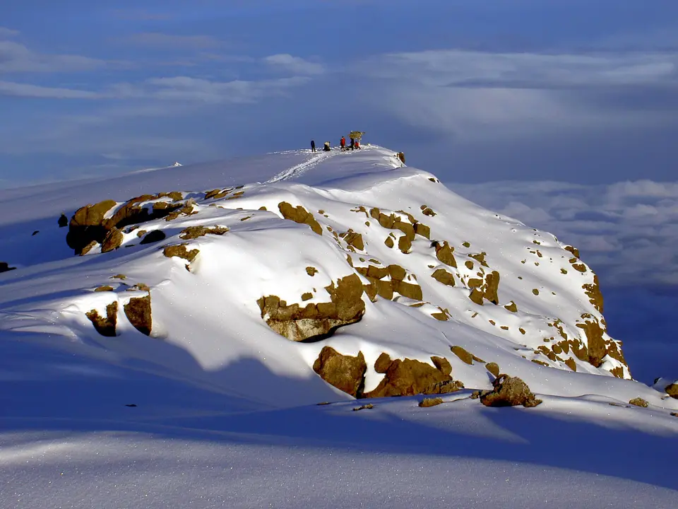
For Tanzania, the UNESCO World Heritage Atlas in 1987 under Criterion (vii) during the eleventh session, Kilimanjaro National Park (known as Hifadhi ya Taifa ya Kilimanjaro in Swahili) protects Mount Kilimanjaro, the highest point in Africa at 5,895 metres above sea level and the world's largest free-standing volcanic mass. Glaciers crown its equatorial summit. Situated about 300 kilometres (190 miles) south of the equator within northern Tanzania's Kilimanjaro Region near the town of Moshi, and frequently approached overland or by air by travellers starting their East African journeys in Nairobi, the volcanic massif rises in dramatic isolation 4,877 metres above the surrounding plains, its snow-clad summit overlooking the open savannah.
Mount Kilimanjaro ranks among the world's largest volcanoes and is composed of three main volcanic peaks: Kibo alongside Mawenzi and Shira. Crowned by its snow-capped peak and equatorial glaciers, Kibo forms the central summit reaching 5,895 metres, while Mawenzi together with Shira rises as an older volcanic cone flanking the massif. Because of this combination of features (above all its immense height alongside its physical form, its snow cap, and its complete isolation above the surrounding plains), the mountain is recognized under Criterion (vii) as a superlative natural phenomenon.
Early in the twentieth century, the German colonial administration proclaimed Mount Kilimanjaro and its encircling forests a game reserve, and in 1921 the area was reclassified as a forest reserve. In 1973, the Tanzanian government established Kilimanjaro National Park to protect the mountain above the tree line (around 2,700 metres, or 8,900 feet) along with six radial forest corridors descending through the montane forest belt across some 75,575 hectares. Declared a World Heritage site in 1987, the park was expanded in 2005 to incorporate the entire montane forest belt down to 1,820 metres (5,970 feet) in elevation, which had previously formed part of the Kilimanjaro Forest Reserve. Today, the enlarged national park spans 1,688 square kilometres (652 square miles) between 2°50' and 3°10' S latitude and 37°10' and 37°40' E longitude.
Five Vegetation Zones and Montane Forest Fauna
Climbing from the base of Mount Kilimanjaro to its 5,895-metre summit takes trekkers through five main vegetation zones arranged from the lowest point to the highest peak: the lower slopes alongside the montane forest, the moorland and heath zone, the alpine desert, and the summit zone. Below the national park boundary, the fertile lower slopes are settled and farmed by the Chaga people, whose villages and agricultural plots ring the base of the volcano. Entering the protected park boundary at 1,820 metres (5,970 feet), climbers pass into the dense montane forest belt that encircles the mountain, absorbing moisture from rising savannah air currents to sustain a lush evergreen canopy.
Around the tree line at approximately 2,700 metres (8,900 feet), the closed montane forest transitions into the moorland and heath zone, where open tussock grasslands and giant heather scrub cover the volcanic ridges. Higher still, as rainfall diminishes and night-time temperatures drop below freezing, the moorland gives way to the stark alpine desert zone spanning the high saddle between Mawenzi and Kibo, before climbers reach the arctic summit zone of snowfields and glaciers crowning Kibo at 5,895 metres.
Because these five ecological zones stack vertically upon a single isolated mountain standing 300 kilometres south of the equator, trekkers experience dramatic shifts in microclimate alongside atmospheric pressure and plant life over the course of a multi-day ascent. Moisture carried inland from the Indian Ocean condenses heavily across the forested belt between 1,820 and 2,700 metres, feeding mountain streams such as the Namwai and Tarakia rivers before giving way to crisp, dry high-altitude air across the upper volcanic saddle.
The whole mountain, and particularly the encircling montane forest belt, is rich in wildlife species, especially mammals, many of which are endangered. Within the montane forests live blue monkeys alongside eastern black-and-white colobuses together with nocturnal bushbabies and leopards. Herds of Cape buffaloes inhabit the montane forest and occasionally move out into the open moorland and grassland, while elephants range through the forest valleys between the Namwai and Tarakia rivers and occasionally ascend to higher elevations on the mountain.
Even above the timberline at 2,700 metres, hardy mammal species have adapted to the thin air and cold nights of the upper zones. Above the tree line, the Kilimanjaro tree hyrax together with the grey duiker and high-altitude rodents are frequently encountered among the boulders and moorland shrubs, while the bushbuck and the red duiker also appear above the timberline in several places.
Seven Designated Ascent Routes and TANAPA Administration
Mount Kilimanjaro is the central focus of the national park, with summit treks accounting for the vast majority of visitor activity. The park is managed by the Tanzania National Parks Authority (TANAPA) from the Park Headquarters at Marangu, situated about 44 kilometres from Moshi town and 86 kilometres from Kilimanjaro International Airport. Annual visitation averages circa 52,000 to 58,460 visitors. During the 2011 to 2012 budget year, TANAPA recorded 57,456 tourists in the park, of whom 16,425 hiked the mountain, remaining well below the maximum capacity of 28,470 climbers set by the park's General Management Plan. During the 2012 to 2013 budget year, the park recorded 58,460 tourists, of whom 54,584 were foreign visitors, generating the second-highest revenue of any Tanzanian national park and operating as one of just two national parks in Tanzania to generate a budget surplus (as the heavily visited Ngorongoro Conservation Area, which includes Ngorongoro Crater, is managed under a separate authority rather than as a national park).
To ensure climber safety and protect the mountain's five ecological zones from erosion and waste, TANAPA enforces strict trekking regulations. Ascents are permitted solely along designated routes and require accompaniment by licensed guides under TANAPA park regulations. Seven officially recognized ascent routes climb Mount Kilimanjaro: the Marangu Route, the Machame Route, the Lemosho Route, the Northern Circuit Route, the Rongai Route, and the Umbwe Route alongside the Shira Route. Approaching the massif from different compass quadrants and crossing the montane forest corridors alongside moorlands and alpine desert at varied paces, these seven regulated trails channel all foot traffic along maintained paths from the park gates at 1,820 metres to the snow-capped summit of Kibo.
By requiring every climbing party to register at the Marangu headquarters or entry gates and follow one of the seven established trails with licensed local guides, TANAPA preserves the wilderness character of the upper moorlands and alpine desert while supporting the regional economy around Moshi and the Kilimanjaro Region. Each ascent route offers trekkers a first-hand journey across all five altitudinal zones, from the shaded forest habitats of colobus monkeys and elephants up to the equatorial glaciers of Kibo at 5,895 metres above sea level.
Few places in the world allow hikers to pass from tropical montane forest through heath alongside moorland and alpine desert to a glacier-rimmed volcanic summit within a single protected park boundary. Protecting the entire forest belt down to 1,820 metres alongside the high volcanic cones of Kibo, Mawenzi, and Shira ensures that the watershed and wildlife habitats of northern Tanzania's greatest mountain remain intact for both local Chaga farming communities on the lower slopes and international climbers ascending to the roof of Africa.
- Five Main Vegetation Zones: Every ascent passes sequentially through the lower slopes alongside the montane forest belt above 1,820 metres, the moorland zone above 2,700 metres, the alpine desert, and the 5,895-metre summit of Kibo.
- Seven Official Ascent Routes: TANAPA regulations require all trekkers to climb with licensed guides along the Marangu, Machame, Lemosho, Northern Circuit, Rongai, Umbwe, or Shira routes.
- Forest & Timberline Mammals: The park shelters elephants between the Namwai and Tarakia rivers alongside Cape buffaloes, leopards, blue monkeys, eastern black-and-white colobuses, and Kilimanjaro tree hyraxes above the tree line.
