Quick Field Data
- UNESCO Inscription: 1998 (Ref. 842), cultural landscape spanning the Province of Salerno, Campania, southern Italy; Criteria (iii) and (iv).
- Scale & Footprint: 159,109.73-hectare protected property uniting Cilento and Vallo di Diano National Park with the archaeological parks of Paestum and Velia plus Certosa di Padula, surrounded by 178,101 hectares of buffer zones.
- Access & Ticketing: Protected under Legislative Decree 42/2004, Law 394/1991 and Law 220/1957 through Ente Parco and regional Soprintendenze; check official Paestum Italy archaeological park and museum websites for combined entry tickets.
- Arrival Logistics: Major commercial flights arrive at Naples International Airport (NAP), 113 kilometres north, near Naples (112 kilometres), with direct regional rail linking straight to Paestum station beside the eastern city walls; Salerno Costa d'Amalfi Airport (QSR) sits 56 kilometres north with more limited schedules.
Poseidonia, Elea-Velia, and Cilento's Three East-West Ridge Corridors
Stretching from the Tyrrhenian Sea inland across steep limestone massifs to the broad Vallo di Diano depression, Cilento preserves a continuous Mediterranean cultural frontier dating back 250,000 years. Stone artefacts, Neolithic farmsteads, Bronze Age villages and Iron Age trails follow three parallel east-west mountain ridges descending between the Sele and Tanagro river basins. Because steep coastal gorges impeded flat shoreline roads, prehistoric travellers and medieval pilgrims alike stayed high along open mountain crests connecting Tyrrhenian bays with Adriatic trade routes. That rugged ridge network makes understanding where Paestum Italy sits on a regional map essential before touring its ruins.
Around 600 BCE, Greek colonists sailing from Sybaris founded Poseidonia near the fertile Sele coastal plain, marking the northern borderland of Magna Graecia against indigenous Etruscan and Lucanian territories. Over two flourishing centuries, civic wealth raised monumental limestone sanctuaries and fostered early democratic institutions before Lucanian forces seized the town in 400 BCE and renamed it Paistos. Roman troops established a Latin colony in 273 BCE under the name Paestum, weaving the port city into expanding peninsula trade. Later shifts in commercial sea lanes, progressive river silting and spreading coastal marshes drove inhabitants away into hill towns during the Early Middle Ages, leaving its temples overgrown and nearly forgotten until the 18th century.
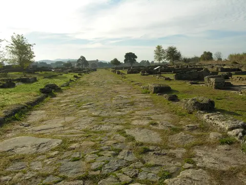
Farther south along the Cilentan coast, Phocaean Greek exiles established Elea during the second half of the sixth century BCE, leaving the substantial ruins of Velia. Excavations there expose monumental fortifications, Roman imperial baths, a medieval tower crowning the acropolis and the celebrated stone archway of Porta Rosa. Together, coastal Paestum and Elea-Velia functioned as classical magnets binding maritime colonies with inland Lucanian strongholds such as Moio della Civitella, Roccagloriosa and Caselle in Pittari. Centuries after Roman paved valley highways fell into disrepair, medieval feudal castles, monasteries and rural hamlets revived the earlier ridge pathways overhead.
Three Archaic Doric Temples and the Painted Tombs of Paestum
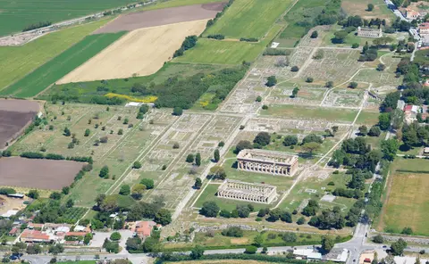
Among all Paestum Italy ruins, three unusually complete Greek Doric temples constructed between 550 and 450 BCE dominate the grassy 25-hectare excavated zone. Ancient Poseidonia covered roughly 120 hectares inside a polygonal limestone circuit wall measuring 4.75 kilometres around, seven metres high and five to seven metres thick, leaving 95 hectares still beneath private farmland. Twenty-four square and round towers punctuated this rampart with four main gates facing cardinal points, though an 18th-century highway cut straight through ancient northern Porta Aurea. Lacking nearby marble quarries, builders cut warm local travertine-limestone blocks and finished facades with painted stucco and bright decorative terracotta reliefs.
Oldest and southernmost stands the First Temple of Hera, erected around 550 BCE and mistakenly dubbed the Basilica by 18th-century antiquarians who thought its wide hall was civic Roman architecture. Its massive columns display pronounced entasis tapering markedly upward beneath broad mushroom-shaped capitals retaining faint traces of original pigment. Nine columns span the short facades and 18 run along the sides, accommodating twin cella doors divided internally by a central row of seven columns. Outside its eastern steps sits the broad open-air altar where worshippers attended sacrifices and left terracotta figurines honouring Hera.
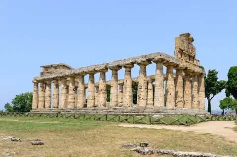
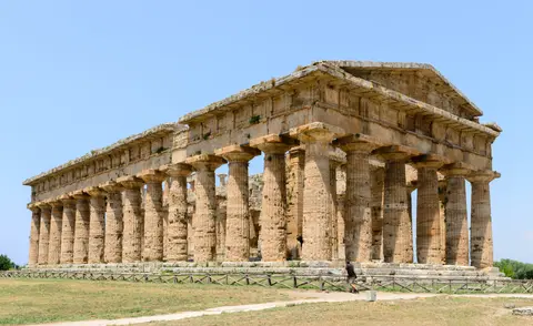
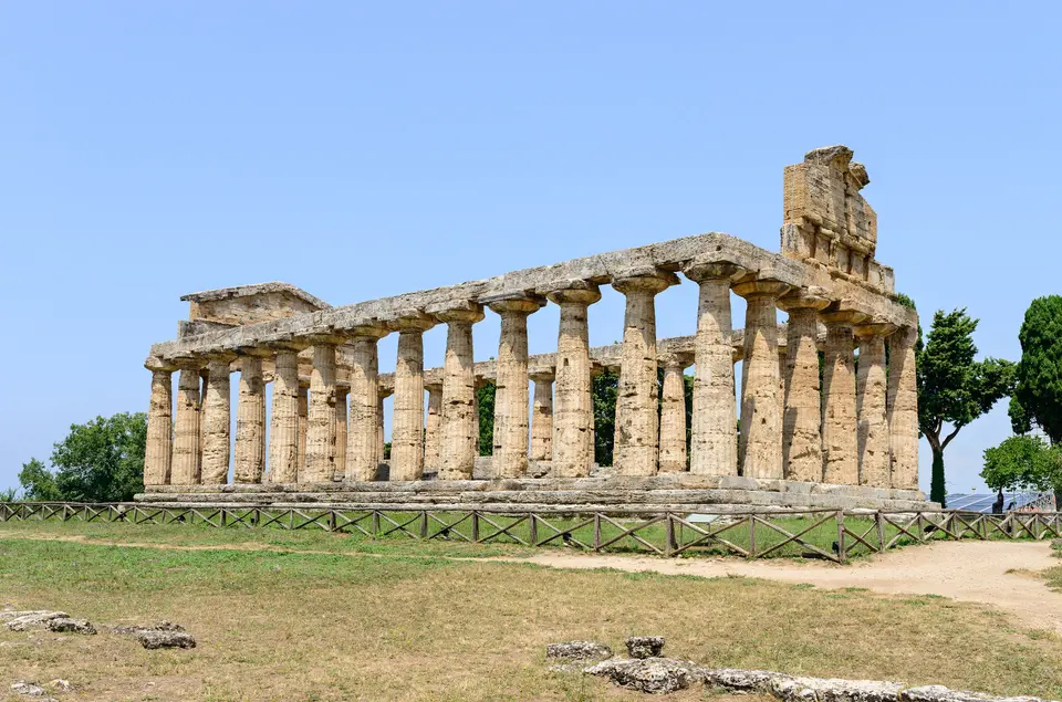
Just north rises the Second Temple of Hera, built around 460 to 450 BCE and long misidentified as dedicated to Poseidon or Neptune. Retaining almost its entire stone entablature and twin pediments, this grand sanctuary departs from normal Doric practice by cutting 24 vertical flutes rather than 20 into thick closely spaced columns. Twin altars on its eastern plaza recall shifting cults, with a smaller Roman altar inserted after builders drove a paved road straight through the larger Greek monument. Across the ancient town centre on slightly higher northern terrain stands the transitional 500 BCE Temple of Athena, blending Doric columns with Ionic porch detailing and concealing three medieval Christian floor burials.
Around the paved streets linking these sanctuaries survive civic monuments spanning Poseidonia's Greek, Lucanian and Roman centuries. The Roman Forum overlays the Greek agora, anchored by a 200 BCE temple of the Capitoline Triad, six smaller Hellenistic shrines and a sunken circular council assembly hall known as the bouleuterion or ekklesiasterion. Nearby sits the low stone heroön mound excavated in 1954 to reveal a pitched-roof chamber holding honey-residue bronze vessels and an Athenian black-figure amphora dated 520 to 500 BCE. Northeast of the forum lies a Roman amphitheatre whose eastern half remains buried under a 1930 road, while Santa Venera south of the walls yielded sixth-century BCE nude terracotta statuettes recalling Phoenician Astarte and later Roman Venus.
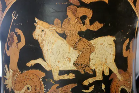
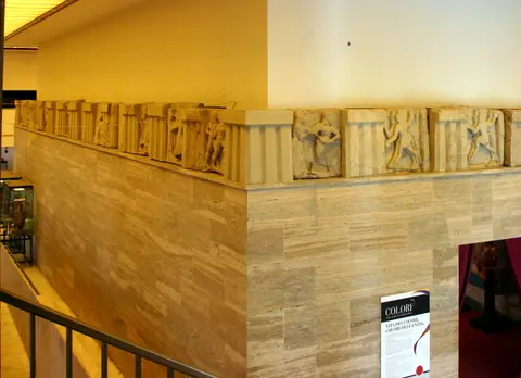
Outside the fortified perimeter, richly frescoed Lucanian and Greek necropolis chambers illuminate ancient funerary beliefs rarely preserved on stone ruins. Found on 3 June 1968 just 1.5 kilometres south of the walls, the celebrated Greek Tomb of the Diver from around 470 BCE uses true fresco technique to show a youth plunging into water. Those fragile tomb slabs now reside inside the National Archaeological Museum next to carved sandstone metopes from Foce del Sele and signed red-figure kraters painted by Asteas. Visitors studying both temples and museum chambers grasp Poseidonia's religious symbolism before stepping back out onto sunlit paved avenues.
Certosa di Padula, Coastal Caves, and Cilento Park Protection
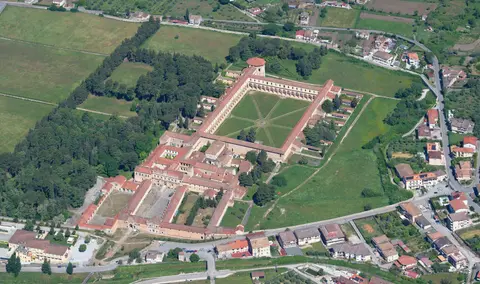
Inland across the fertile Vallo di Diano plain stands the third monumental anchor of the World Heritage site, the Certosa di San Lorenzo at Padula. Begun in 1306 as a Carthusian monastery, its sweeping cloisters, monastic cells and grand staircases acquired their present Baroque form through extensive 17th- and 18th-century reconstructions. Today the monumental charterhouse preserves vast vaulted wings as well as the Archaeological Museum of Lucanian Antiquities documenting inland Italic settlements. Pairing classical coastal ports with this highland monastic complex illustrates why Cilento earned recognition across 159,109.73 hectares of varied landscapes.
Beyond ancient stones, the Parco Nazionale del Cilento, Vallo di Diano e Alburni protects diverse Mediterranean habitats established under Italian Law 394/1991 on 6 December 1991 to curb coastal speculation and mass tourism. Designated Integral Reserves under June 2010 park programmes shield the central Pruno woodland, karst gorges around Castelcivita and Pertosa, and coastal caves near Marina di Camerota. Along the Tyrrhenian shoreline lie the marine reserve of Punta Licosa at Castellabate, Palinuro headlands, Punta degli Infreschi and wetland sanctuaries across the Foce Sele-Tanagro reserve created in 1993 including the Oasis of Persano. Meanwhile, modern seaside Paestum directly south of Porta Giustizia pairs long sandy beaches with ancient pine-shaded ruins inside the wider Capaccio Paestum comune.
Three tiered legal shields and 178,101 hectares of surrounding buffer zones regulate conservation across public and private properties managed from park headquarters at Piazza Santa Caterina in Vallo della Lucania. Legislative Decree 42/2004, Italian Forest Law, Law 220/1957 guarding a one-kilometre landscape belt outside Paestum's city walls and Natura 2000 assessments govern any construction through regional Soprintendenze and Ente Parco. Carefully documented archaeological work has conserved all three Doric temples, three Roman residential blocks, the eastern circuit walls, Velia's Porta Rosa, Roman baths, Padula's Baroque cloisters and a dedicated Museum of Prehistory and Protohistory section. Ongoing vigilance manages landslides, seasonal flooding and unauthorised building pressures across the vast Vallo della Lucania park territory.
Access Zones Across Paestum, Velia, Padula, and Cilento
Because monuments span coastal flats, rocky headlands and deep inland valleys, divide sightseeing cleanly by geographic hub rather than rushing all four sectors in one day. Check current combined tickets and opening updates on official park notices before arrival.
| Complex Zone | Key Highlights | Access & Ticket Rule |
|---|---|---|
| Paestum Archaeological Park & Museum | Three Archaic Doric temples, 4.75-kilometre circuit walls, Roman Forum, Tomb of the Diver and Foce del Sele metopes. | Fenced ruins and adjacent national museum east of modern Capaccio Paestum; check official site notices for tickets. |
| Elea-Velia Archaeological Site | Sixth-century BC Phocaean Greek settlement remains, vaulted Porta Rosa arch, Roman baths and medieval acropolis tower. | Located southward along the Tyrrhenian coast; verify seasonal shuttle paths up the acropolis hill at ticket offices. |
| Certosa di Padula (Vallo di Diano) | Baroque Carthusian cloisters begun in 1306 and the Archaeological Museum of Lucanian Antiquities. | Accessible inland across the Vallo di Diano valley; confirm guided courtyard access and restoration closures locally. |
| Cilento Coast & Mountain Reserves | Punta Licosa marine reserve, Palinuro, Marina di Camerota sea caves, Pruno forest and prehistoric ridge trails. | Protected Natura 2000 park territory under Ente Parco; stay on marked footpaths and observe marine reserve rules. |
Three Classical Masonry Details Visible Inside Paestum
- Pronounced Column Entasis on the First Temple of Hera: Sight along the 550 BCE southern colonnade to notice strong outward curvature and wide mushroom capitals retaining weathered traces of ancient paint.
- Nine-Column Front and Central Cella Row: Count the odd nine columns spanning the Basilica's short facades, aligned so neither twin sanctuary entrance was blocked by a middle column.
- Cut Greek Altar Beside the Temple of Hera II: Look east of the 460 BCE sanctuary where Roman road builders sliced straight through the earlier monumental stone altar and erected a smaller shrine nearby.
How to Get to Paestum From Naples and Pair Coastal Ruins
Travellers asking is Paestum worth visiting quickly find that its intact sixth-century BC Greek colonnades rival Athens and Sicily while sitting inside relaxed coastal parkland. Paestum railway station sits right on the Naples-Salerno-Reggio Calabria rail line immediately east of the ancient walls, making day excursions straightforward without hiring a car. Visitors checking how to get to Paestum from Naples reach the ruins comfortably in one direct train ride, while reaching inland Padula, mountain villages and southern Velia rewards onward regional rail or highway driving.
Pairing morning temple walks with afternoon museum visits and nearby sandy Paestum beaches creates an easy southern Campania rhythm. Start early among the open travertine columns of Hera I, Athena and Hera II before midday heat builds, then step inside the shaded National Archaeological Museum to inspect the Tomb of the Diver frescoes and Asteas pottery. Allowing a second or third day unlocks coastal Elea-Velia near Marina di Camerota's karst cliffs or inland Certosa di Padula across the Vallo di Diano.
International arrivals commonly touch down at Naples International Airport (NAP), 113 kilometres north, before linking south through Naples (112 kilometres) by rail or highway. Closer Salerno Costa d'Amalfi Airport (QSR) lies 56 kilometres north of the protected region, though scheduled flight coverage remains far narrower than Naples. Explore additional classical sanctuaries across Italy and the Mediterranean inside our UNESCO World Heritage Atlas.