


























Quick Field Data
- UNESCO Inscription: 1988
- Scale & Footprint: A densely clustered 5-square-kilometre ceremonial core connected by over 80 paved sacbeob causeways in Tinúm Municipality between Valladolid and Mérida, Yucatán, Mexico
- Access & Ticketing: Federal archaeological zone managed by INAH with modern visitor facilities at Catvi and protected monument perimeters (climbing El Castillo and entering the inner throne room have been closed since 2006); check the official site
- Arrival Logistics: Located in eastern Yucatán state on the northern karst plain and accessible by highway or rail links between Mérida, Valladolid, and Cancún
Karst Cenotes, Itza Hegemony, and Mayan-Toltec Cultural Synthesis
Situated in Tinúm Municipality midway between Mérida and the eastern city of Valladolid on the northern karst limestone plain of Yucatán, Mexico, the Pre-Hispanic City of Chichen-Itza was the pre-eminent ceremonial, political, and economic capital of the Northern Maya Lowlands across the Late Classic (600 to 900 AD), the Terminal Classic (800 to 900 AD), and the early Postclassic era (900 to 1200 AD). Because the northern peninsula lacks surface rivers, settlement depended on natural collapse sinkholes (known in Yucatec Maya as chʼeʼen or cenotes) aligned along the buried permeable fracture ring of the Tertiary Chicxulub impact crater. Established near 4 open cenotes led by the Xtoloc water source and the ceremonial Cenote Sagrado, the city took the name Chichén Itzá, derived from Maya terms signifying the rim of the Itza water well, while Late Classic hieroglyphs and the Chilam Balam de Chumayel record an earlier title variously translated as Uuc Yabnal, Uuc Hab Nal, Uucyabnal, or Uc Abnal. Local chronicles cite early founding dates of 415 to 35 AD or 455 AD, while archaeological stratigraphy places core urban growth around 750 AD, with carved lintel dates spanning from 832 AD in the Temple of the Initial Series to 998 AD in the Osario. In the 10th century, traditionally linked to the arrival of Ce Acatl Topiltzin Quetzalcoatl (Kukulkan) from Tula between 967 and 987 AD or broader Mesoamerican cultural diffusion, the metropolis fused northern Maya Puuc and Chenes masonry with central Mexican plateau imagery.
At its apogee between 900 and 1050 AD, Chichen Itza controlled trade across northern and central Yucatán through its fortified north-coast island port of Isla Cerritos and Vista Alegre, importing central Mexican obsidian and southern Central American gold while extracting tribute from rivals as southern allies Yaxuna and Coba declined. Although the Book of Chilam Balam relates that Hunac Ceel of Mayapan conquered the city in the 13th century after surviving a leap into the Cenote Sagrado, archaeological data directed by Rafael Cobos indicates that elite monumental activity declined around 1100 AD prior to Mayapan's ascendancy. In 1526 Spanish conquistador Francisco de Montejo petitioned the King of Spain to conquer Yucatán; after campaigns in 1527 at Xaman Ha (near modern Cancún) and 1531 at Campeche, his son Francisco Montejo the Younger occupied Chichen Itza in late 1532, renaming it Ciudad Real, before a Maya siege cost 150 troops and forced a nocturnal retreat in 1534 (with all Spaniards driven from Yucatán by 1535 prior to later conquest and a 1588 cattle ranch grant).
Following early visits by Benjamin Norman, Baron Emanuel von Friedrichsthal, and the landmark 1843 book by John Lloyd Stephens and illustrator Frederick Catherwood recounting their Yucatán travels, photographers and scholars documented the ruins: Désiré Charnay in 1860 (published in 1863), Augustus Le Plongeon and Alice Dixon in 1875 (who unearthed and named the reclining Chac Mool sculpture), and Teobert Maler and Alfred Maudslay in the 1880s. In 1894 United States Consul Edward Herbert Thompson purchased Hacienda Chichén, exploring the ruins for 30 years and dredging gold, jade, copper, cloth, wooden weapons, and human bones from the Cenote Sagrado between 1904 and 1910 for Harvard University's Peabody Museum (sparking a 1926 Mexican lawsuit resolved by the Supreme Court in 1944 before sale to Fernando Barbachano Peon, while Governor Felipe Carrillo Puerto opened the first highway in 1923). After the Mexican Revolution delayed Sylvanus Morley's 1913 proposal for a decade, researchers from the Carnegie Institution of Washington, including Earl Morris at the Temple of the Warriors from 1925 to 1928, and Mexican government archaeologists restored the principal complexes, followed by 1961 and 1967 cenote dives, a 2010 land purchase by Yucatán state, and ongoing INAH stewardship.
The Great North Platform, El Castillo, the Caracol, and Puuc Palaces
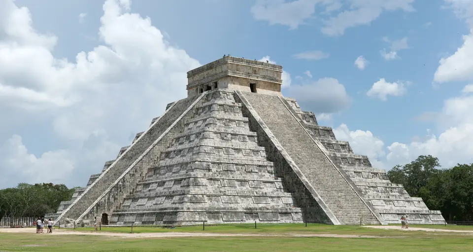
Covering a densely built core of at least 5 square kilometres (1.9 square miles) across artificially levelled limestone terrain and linked by more than 80 white paved causeways (sacbeob) once flanked by buildings painted in red, green, blue, and purple pigments, the city divides into distinct walled architectural compounds. Dominating the Great North Platform is the Temple of Kukulcán (El Castillo), a 9-terraced step pyramid rising 30 metres (98 feet), comprising 24 metres of 2.57-metre terraces plus a 6-metre summit temple, above a square base measuring 55.3 metres (181 feet) per side, with terrace walls inclined at 53 degrees, talud panels at 72 to 74 degrees, and 4 axial stairways rising at 45 degrees (the northern balustrades terminating in carved serpent heads that frame triangular shadow patterns around the spring and autumn equinoxes). Beneath the exterior pyramid, 1930s Mexican excavations tunnelled into an earlier buried temple housing a Chac Mool and a red-painted jaguar throne inlaid with jade spots, while 2015 electrical resistivity tomography (ERT) detected a subterranean freshwater cenote node directly beneath the pyramid and 2025 multimodal 3D scanning mapped the multi-stage "Castillo-sub" substructure.
One hundred and fifty metres northwest of El Castillo stretches the Great Ball Court, the largest in Mesoamerica at 168 by 70 metres (551 by 230 feet), flanked by parallel 95-metre-long, 8-metre-high walls bearing carved feathered-serpent stone rings and sloped benches sculpted with decapitated ballplayers, bookended by the North Temple (Temple of the Bearded Man) and the Upper and Lower Temples of the Jaguar. East of the court stand the Skull Platform (tzompantli), the carved Platform of the Eagles and Jaguars, and the Platform of Venus, from which Sacbe Number One runs 270 metres long and 9 metres wide northwards to the Cenote Sagrado, a sheer-walled karst sinkhole 60 metres in diameter dropping 27 metres to a halocline-stratified water table, near which a 1967 airstrip crew uncovered a chultun cave holding remains of over 100 male children, including identical twins confirmed by 2020s DNA analysis. Flanking the eastern side of the Great North Platform is the Temple of the Warriors, encasing the older Temple of the Chac Mool with mural scenes recorded in watercolours by Earl Morris and fronted by the Group of a Thousand Columns (whose northeast channel drains rainwater 40 metres into a rejollada), the Temple of the Carved Columns (40 relief figures), Thompson's Temple (Palace of Ahau Balam Kauil), the Steam Bath, and the colonnaded gallery of El Mercado.
South of the Great North Platform, the Osario Group centres on the stepped pyramid of the Osario (High Priests' Temple, bearing a 998 AD inscription), whose summit opening drops 12 metres into a natural burial cavern excavated by Edward Thompson, alongside the Temple of Xtoloc overlooking the Xtoloc cenote. Further south in the Central Group and Chichén Viejo (Old Chichén), classic Maya Puuc block-masonry and Chenes monster-mask facades prevail across the circular astronomical observatory of El Caracol ("the snail", named for its interior spiral staircase), the multi-phase palace complex of Las Monjas (the Nunnery) with its ornate Annex and La Iglesia (the Church), the flat-roofed Akab Dzib ("House of Dark Writing"), the red-banded Casa Colorada (Chichan Chob, carrying an 869 AD hieroglyphic band), the Temple of the Panels, the Temple of the Deer, and the southern groups of the Initial Series, the Lintels, and the Old Castle.
Navigating the Great North Platform, Sacred Cenote, and Southern Puuc Sector
Visiting Chichen Itza with the UNESCO World Heritage Atlas requires an early start through the Visitor Attention Center (Catvi), as the archaeological zone welcomes over 2,000,000 to 2.6 million visitors annually and daytime heat across the unshaded Great North Platform is intense. Entering onto the main esplanade, walkers first encounter the 30-metre pyramid of El Castillo before circling counter-clockwise to the 168-by-70-metre Great Ball Court, the Skull Platform, the Eagle and Jaguar platform reliefs, and the 270-metre Sacbe Number One leading north to the viewing rim of the 60-metre-wide Cenote Sagrado. To protect the ancient masonry, INAH closed both the exterior stairways and the interior jaguar-throne tunnel of El Castillo to visitors in 2006.
After walking through the forest of carved pillars at the Temple of the Warriors, the Group of a Thousand Columns, and El Mercado on the eastern flank of the Great North Platform, visitors should continue south past the Osario pyramid and the Xtoloc cenote into the Central Group. Here, the circular dome of the Caracol observatory, the Puuc mosaic friezes of Casa Colorada and La Iglesia, the Chenes doorway of the Las Monjas Annex, and the hieroglyphic lintels of Akab Dzib illustrate the older Maya architectural traditions of Yucatán. Shade is scarce at midday.
- Arriving at gate opening: Reach the entrance before tour coaches arrive from Cancún and Mérida so you can walk the Great Ball Court, El Castillo, and the Temple of the Warriors in cooler morning air.
- Following the northern and southern stylistic shift: Compare the Mayan-Toltec feathered-serpent columns and warrior reliefs on the Great North Platform with the earlier Puuc stone mosaics and Chenes masks around Las Monjas, La Iglesia, and the Caracol in the southern sector.
- Walking Sacbe Number One: Follow the 270-metre white limestone causeway from the Platform of Venus to the rim of the Cenote Sagrado to see how the city's ceremonial layout connected directly to the Chicxulub karst water table.
