Quick Field Data
- UNESCO Inscription: Cultural site inscribed in 1995 (Ref. 734) under criteria (iv) and (v).
- Scale & Footprint: 68 hectares divided among three mountain settlements along the Shogawa river valley: Ogimachi (Gifu Prefecture), Ainokura, and Suganuma (Toyama Prefecture), surrounded by individual village buffer zones (including 471.5 hectares around Ogimachi) and a 545.38-square-kilometre outer buffer zone.
- Access & Ticketing: These living historic villages are designated Important Preservation Districts for Groups of Historic Buildings. Outer lanes stay open on foot, while preserved farmhouse interiors such as Wada House and folklore halls charge local entry tickets. Travellers should check official municipal sites for shuttle parking and seasonal highway bus schedules.
- Arrival Logistics: Komatsu Airport / JASDF Komatsu Air Base (KMQ, 45 kilometres west) acts as the closest commercial air link, while Kyoto lies 180 kilometres southwest.
Shogawa Valley Isolation, Sacred Mount Hakusan, and Mountain Faith
Cut into the rugged Chubu mountains of central Honshu, the Sho River (Shogawa) rises in southern peaks and flows northward toward the Sea of Japan along a deep winding gorge flanked by ridges reaching 1,500 metres (4,921 feet). Dense mountain forests still occupy 96 percent of all surrounding terrain, confining human settlement to narrow alluvial strips and terraced shelves along the valley floor. Heavy winter snowfalls and precipitous mountain passes isolated Shirakawa-go (White River Old-District) in Gifu Prefecture and Gokayama (Five Mountains) in Nanto, Toyama Prefecture from Japan's coastal plains until modern highways arrived around the 1950s, earning the valley a reputation as Japan's last unexplored area.
Sacred geography long shaped settlement in this upland basin. Dominating the skyline, Mount Hakusan was venerated from ancient times and drew ascetic mountain practitioners into Shirakawa-go and Gokayama during the 8th century. Tendai Buddhism held sway over local religious life for centuries until replaced in the 13th century by the Jodo Shinshu (Jodo Shin) sect, whose Buddhist temples still anchor community worship in Ogimachi and Ainokura beside local Shinto guardian shrines. Popular regional memory also preserved Ochi-udo Densetsu, traditions of defeated warriors seeking refuge inside hidden mountain recesses.
By the 11th century, permanent farming communities already occupied these valley shelves, structured later under Japan's rural Mura administrative system. With scarce level farmland and cold mountain winters limiting conventional wet-rice harvests, farmers cultivated buckwheat and millet on small sloping plots while relying on forest-and-house crafts that could thrive indoors through months of deep snow. Marketable exports rested on three specialised industries: handmade washi mulberry paper, raw nitre processed for gunpowder manufacture, and sericulture, the indoor rearing of silkworms.
Gassho-zukuri Roof Geometry, Sericulture Lofts, and Sub-Floor Nitre
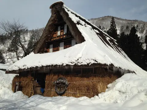
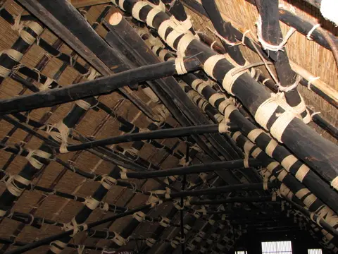
Facing heavy alpine snow loads and limited flat building plots, valley carpenters developed the gassho-zukuri farmhouse, named for its steeply pitched thatched gable roofs resembling two hands pressed together in prayer. Engineered before heavy earth-moving machinery existed on stone-retained terraces, each massive wooden frame encloses three to four stacked storeys beneath sweeping low eaves. Nowhere else in Japan were steep roof attics subdivided into multiple working storeys on this residential scale, housing large extended families downstairs while devoting entire timber-floored upper lofts to industry.
Sericulture, traced back to the 16th century and established as a primary rural side industry from the late 17th century until vanishing in the 1970s (with only a World War II interruption), dictated those multi-tiered attics. Families gathered mulberry leaves from uphill plots to feed densely stacked trays of silkworms inside warm upper rafters heated passively by the open ground-floor hearth rising through slatted ceilings. Beneath the ground floor, earthen pits simultaneously yielded nitre, one of the raw ingredients needed for gunpowder production.
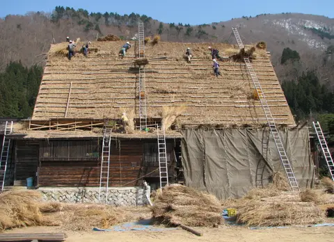
Maintaining monumental thatched roofs demands an enduring mutual-aid institution known as yui (or koryaku in Shirakawa-go). Modern National Trust volunteers now work alongside villagers to counter rural depopulation, aging households, and shrinking primary industries. Re-thatching a single gassho roof every 30 to 40 years begins at least three years ahead of schedule, calculating thatch quantities from roof area and harvesting reeds from reserved common thatch fields. Roles divide cleanly: village men gather, carry, sort, and tie ropes while village women prepare hot meals, rest snacks, and completion gifts. Teams of 200 to 300 workers assemble on wooden scaffolding, usually finishing one roof side in two days without financial pay. Rarely are both roof slopes re-thatched simultaneously, spreading labour across cycles so neighbouring farmsteads maintain food production and daily routines without disruption. Beyond roofing, koryaku bonds still extend across weddings, funerals, rice planting, harvesting, weeding, and firewood gathering, reinforced by outside National Trust volunteers travelling into the valley to keep traditional thatch skills alive.
Ogimachi, Ainokura, and Suganuma Across Two Prefectures
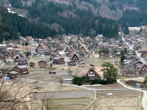
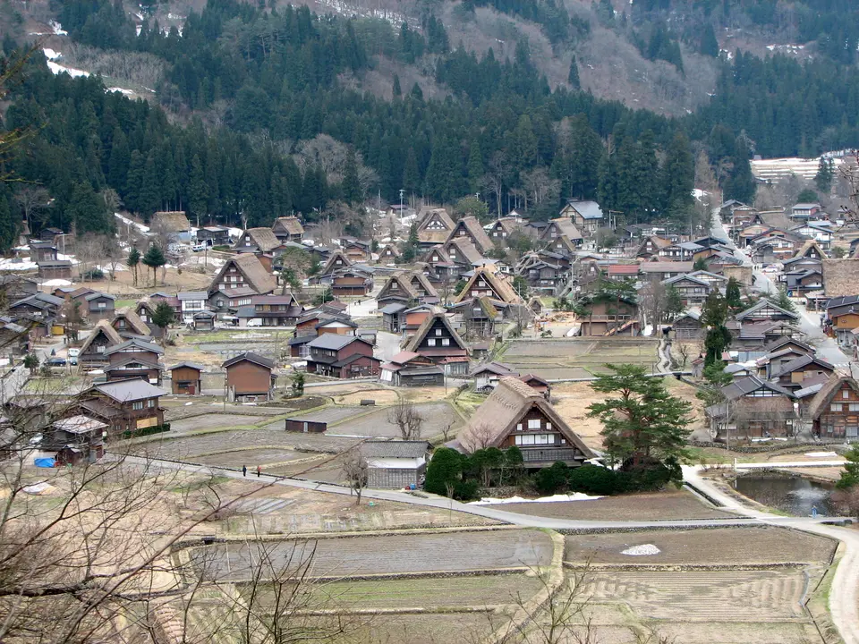
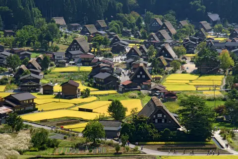
Although all three World Heritage settlements sit along the same river valley across the Gifu-Toyama border, their scale, altitude, and historical traces differ markedly on the ground. Ogimachi in Shirakawa-go is by far the largest village, spreading across a terrace roughly 1,500 metres long and 350 metres wide on the eastern bank of the Sho River at around 500 metres elevation. Recording 99 households in 1876 (the largest of 23 hamlets in Shirakawa-Muri) and 152 households with 634 inhabitants in August 1994, Ogimachi retains 117 designated historic buildings and seven structures. These include 59 gassho-zukuri houses built mainly from the early nineteenth to early twentieth centuries, separated by small cultivated plots with larger grain plots north and south. Houses connect via 2-to-4-metre Edo lanes and a 6-metre 1890 north-south spine, forming an open village layout framed by road boundaries rather than walls. On steep foothills, houses occupy stone-retained terraces punctuated by a south-central Shinto shrine and two Jodo Shinshu temples.
Further downstream inside Nanto's Gokayama district, Ainokura perches at roughly 400 metres elevation on a narrow elevated terrace west of the Sho River. Dropping from 47 households in 1887 (fourth largest of 25 Taira-mura villages) to 27 households with 90 residents in August 1994, Ainokura preserves 67 historic buildings and five structures. Its designated gassho farmhouses have grown from 20 originally to 23 today. While the oldest survives from the late seventeenth century, most date from the early nineteenth to early twentieth centuries on four-room square or six-room plans with earthen floors. Ainokura led Taira-mura in sericulture until the 1950s push for food self-sufficiency converted elevated mulberry terraces into small irregular rice paddies watered by an aqueduct descending from western mountain streams. A cedar-ringed hilltop Shinto shrine and a Jodo Shinshu temple anchor the village beside an 1887 mountain road and wider 1958 street.
Suganuma forms the smallest inscribed settlement at around 330 metres elevation, tightly enclosed on a stone-walled shelf measuring just 230 by 240 metres against steep southern mountain slopes. Recording 13 households in 1889 (ninth largest of 19 Kamitaira-mura villages) and just 8 households with 40 residents in 1994, Suganuma preserves 28 designated buildings and two structures. Its nine surviving gassho houses include two from the early nineteenth century, six from the Meiji period (1868 to 1912), and the valley's final new gassho construction completed in 1926, with irrigation replacing mulberry fields in 1945. Detached storehouses in wood or earthen plaster reduce fire spread, while the local Shinto guardian shrine occupies a low rise after two relocations since the 1930s. Felling trees on the steep southern forest wall remains prohibited so woodland holds winter snow back from the settlement.
Village Layouts, Historic House Museums, and Fire Protections
All three villages are protected under Japan's 1950 Law for the Protection of Cultural Properties as Important Preservation Districts for Groups of Historic Buildings. Ainokura and Suganuma also carry national Historic Site and Gokayama Prefectural Natural Park listings. Preservation plans unite Japan's Agency for Cultural Affairs with the ministries for the Environment, Agriculture, Forestry and Fisheries (including the Forestry Agency), and Land, Infrastructure, Transport and Tourism. At regional level, oversight pairs Gifu and Toyama prefectures directly with Shirakawa Village and Nanto City. Shirakawa Village enforces its 1973 Natural Environment Ordinance reinforced by the 2008 Landscape Ordinance covering 471.5 hectares. Individual owners take direct responsibility for daily maintenance and roof care using traditional techniques and materials supervised against Preservation Plans. Public subsidies and technical guidance support work where standardised modular wooden joints allow repairs with minimal conjecture. When major highway construction approached within less than one kilometre of Ogimachi and Suganuma, authorities buffered scenic vistas through embankment plantings and bridge-design controls. Municipal rules under Shirakawa Village and Nanto City require advance notification and design scrutiny for any large-scale project near the 471.5-hectare Ogimachi buffer or the 545.38-square-kilometre outer landscape zone. These controls keep historic roads, irrigation canals, village woodland, and surrounding agricultural terraces free from intrusive modern alterations. Because residents still live and farm inside each village, visiting requires respecting private thresholds while entering open house museums.
| Complex Zone | Key Highlights | Access & Ticket Rule |
|---|---|---|
| Ogimachi Village (Shirakawa-go) | 59 aligned gassho-zukuri houses, 1890 central spine road, Jodo Shinshu temples, and Wada House | Free village lane walking; major preserved residences require individual admission tickets |
| Ainokura Village (Gokayama) | 23 gassho farmhouses back to the late 17th century, aqueduct canals, and mountain rice terraces | Open pedestrian village lanes; museum farmhouses charge entry and visitor parking |
| Suganuma Village (Gokayama) | Compact 9-house river-shelf cluster, detached earthen storehouses, and avalanche-buffer forest | Open daytime walks with paid museum interiors and controlled access away from resident homes |
| Double Heritage Buffer Zones | 471.5-hectare Ogimachi inner buffer and 545.38-square-kilometre regional valley landscape | Highway viewpoints and roadside tree plantings protect historic vistas less than 1 kilometre away |
Three Timber-Thatch and Stone Details to Inspect in the Villages
Slowing down along the narrow Edo-period irrigation lanes exposes practical engineering tucked inside every roofline and terraced plot.
- Parallel River Roof Orientation: Standing at an elevated terrace edge above Ogimachi, observe how almost every gassho-zukuri ridge runs parallel to the Sho River rather than at random angles, maximising winter sunshine exposure and channelling strong valley winds evenly past gable faces.
- Stone-Retained Terrace Walls and Aqueduct Canals: Along steep edges of Ainokura and Ogimachi, trace dry-laid stone retaining embankments supporting narrow building plots beside clear mountain-fed irrigation channels that double as summer drainage and winter snow-melt conduits.
- Concealed Fire-Suppression Hydrants: Across all three villages, look for small wooden gable-roofed boxes beside lanes housing high-pressure water nozzles installed under Japan's 1950 Cultural Properties Law to let resident fire-fighting squads protect vulnerable dry thatch roofs immediately.
Winter Snowfall, Autumn Re-Thatching, and Pairing with Kyoto
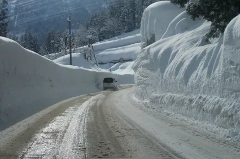
Every season shifts both visual drama and practical access in the Shogawa valley. Mid-winter blankets Ogimachi, Ainokura, and Suganuma in deep snow that demonstrates exactly why gassho roofs pitch so steeply, though mountain winds and icy paths demand warm waterproof footwear. Spring snowmelt fills the village aqueduct canals beside fresh shoots, summer illuminates surrounding 96-percent forested ridges and valley rice plots, and crisp autumn brings clear visibility before early frosts.
Express buses and Hokuriku rail transfers link Kanazawa, Toyama, and Komatsu Airport (KMQ) southward into Kansai, making the valley a natural mountain contrast with our Kyoto travel guide, situated 180 kilometres southwest. Readers planning broader cultural circuits across Japan's castles, shrines, and rural valleys can browse neighbouring entries in the UNESCO World Heritage Atlas.