


























Quick Field Data
- UNESCO Inscription: Inscribed in 1982 as a Natural heritage site under criteria (vii) and (x) across the Montagnes and Bas-Sassandra districts of southwestern Côte d'Ivoire.
- Scale & Footprint: Core national park covering 3,300 square kilometres (330,000 hectares) with a 200-square-kilometre buffer zone inside a 4,540-square-kilometre evergreen forest reaching 396 metres at Mont Niénokoué.
- Access & Ticketing: Protected national park requiring advance entry permits alongside health precautions and mandatory accompaniment by park rangers; check the official site before planning field excursions.
- Arrival Logistics: Located approximately 100 kilometres from the Ivorian coast along the Liberian border between the Cavalla and Sassandra rivers.
Granite Inselbergs and Ice Age Refugia in the Upper Guinean Forest
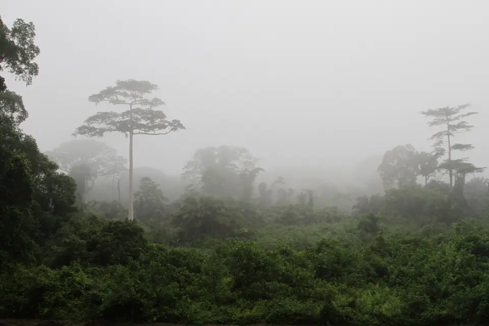
The canopy is dense. Ancient trees tower above the rivers. Situated in the south-western corner of Côte d'Ivoire (Ivory Coast) approximately 100 kilometres (62 miles) from the coast along the border with Liberia between the Cavalla (or Cavally) and Sassandra rivers, Taï National Park (Parc National de Taï) protects one of the largest surviving expanses of primary tropical rainforest in West Africa. First created as a forest reserve in 1926, promoted to national park status on 28 August 1972 when commercial timber exploitation officially ceased, designated a biosphere reserve by UNESCO in 1978, and inscribed on the Natural World Heritage List in 1982 as site number 195, the park covers 3,300 square kilometres (330,000 hectares, or 1,300 square miles) with a 200-square-kilometre (77-square-mile) buffer zone inside a broader 4,540-square-kilometre (1,750-square-mile) tropical evergreen forest whose adjoining northern N'Zo Faunal Reserve abuts the vast Buyo Dam reservoir fed by the N'zo alongside the Sassandra River.
Geologically, the forest is situated on an ancient Precambrian granite peneplain of migmatites alongside biotites and gneiss at a plateau elevation between 150 and 200 metres (490 and 660 feet), descending from the gently rolling, drier northern plateau into deeply dissected southern valleys where altitudes vary from 80 metres (260 feet) to 396 metres (1,299 feet). Breaking through the plateau are several granite inselbergs formed from plutonic intrusions, culminating in Mont Niénokoué at 396 metres in the southwest. Across the park, a broad belt of varied schists trends from northeast to southwest, dissected by parallel tributaries (the N'zo and Meno alongside the Little Hana and Hana rivers) that drain southwest into the Cavally River, becoming wide waterways in the wet season and shallow streams in the dry season over leached ferralitic soils in the north and fertile alluvial hydromorphic gley soils in the southern valleys containing small quantities of gold.
Spanning two distinct sub-equatorial climatic zones shaped by prevailing south-west monsoonal winds and oceanic influence, mean annual rainfall varies between 1,700 millimetres (67 inches) in the northern sector and 2,200 millimetres (87 inches) in the southwest, falling from March or April through July before a briefer rainy period arrives between September and October, maintaining high relative humidity (85 percent) and small temperature fluctuations between 24 and 27 degrees, with diurnal ranges of 25 to 35 degrees. While the south has no dry season, the northern dry season from November to February or March has been accentuated since about 1970 by dry northeasterly Harmattan winds after half the country's forests were felled; in 1986, Ivory Coast suffered a 30 percent rainfall deficit after 90 percent of the country was deforested over fifty years, diminishing evapotranspiration. Consequently, Taï remains the largest intact island of the vast primary Upper Guinean rainforest that formerly extended from Togo and Ghana westward through Ivory Coast and Liberia as well as Sierra Leone all the way to Guinea-Bissau, having served as an Ice Age refugium within a WWF and IUCN Centre of Plant Diversity.
Emergent Ebony Canopies alongside Pygmy Hippos and Tool-Using Chimpanzees
Beneath Upper Guinean evergreen ombrophilous forest where 40-to-60-metre emergent trees rise on massive trunks and stilt roots, the sanctuary shelters roughly 1,300 higher plant species, 54 percent of which are restricted to the Guinean zone while more than 50 species are regional endemics. Grading from moist semi-evergreen forest in the north to southern moist evergreen forest rich in leguminous trees across the lower third (with abundant lower-level epiphytes and lianes including Platycerium and Nephrolepis biserrata alongside Drymaria and Asplenium africanum), the southwestern Sassandrian evergreen forest growing on schistose soils along the lower Cavally Valley as well as the Meno and Hana basins around Mont Niénokoué is dominated by ebony (Diospyros gabunensis and Diospyros chevalieri), Mapania baldwinii, Mapania linderi, Heritiera utilis (Tarrietia utilis), the rediscovered Amorphophallus staudtii once thought extinct, and the last surviving stands of the tall endemic tree Kantou guereensis. Poorer northern and south-eastern soils support the palm Eremospatha macrocarpa, West African ebonies Diospyros mannii and Diospyros kamerunensis, and Parinari chrysophylla alongside Chrysophyllum perpulchrum and Chidlowia sanguinea; river backwater and oxbow swamp forests host Gilbertiodendron splendidum alongside Symphonia globulifera and Raphia; and inselbergs carry savanna-like grassland with deciduous Spathodea campanulata. Local communities still rely on forest plants: the fruit of Thaumatococcus daniellii (known locally as katamfe, katempfe, or yoruba soft cane) serves in traditional medicine and yields a natural protein compound five thousand times sweeter than sugar cane, while the bark of Terminalia superba (known as the malaria tree) is harvested by ethnic Kroumen healers to treat malaria.
Isolated between two major rivers, the park shelters nearly 1,000 vertebrate species: 140 mammal species alongside 47 of the 54 large mammal species known to occur in the Guinean rainforest, with twelve regional endemics plus five mammal species on the Red List of Threatened Species, namely the dwarf or pygmy hippopotamus (Hexaprotodon liberiensis, numbering around 500 in 1996) alongside Jentink's duiker, leopards, chimpanzees, and olive colobus monkeys. Primates inside the park encompass 11 distinct monkey and prosimian species, including the western red colobus and Diana monkey alongside Campbell's mona monkey, both lesser and greater spot-nosed monkeys, black-and-white colobus, and ursine colobus and green colobus, sooty mangabey, and dwarf galago plus Bosman's potto, alongside West African chimpanzees (Pan troglodytes verus), which numbered more than 2,000 in the 1980s and were estimated by Marchesi in 1995 at 4,507 in Taï with 292 in N'Zo (though numbers declined over the next 15 years) and are famous for using tools. Indigenous Guéré and Oubi forest communities traditionally avoided hunting chimpanzees due to totemic taboos, whereas after the late 1960s, when N'Zo reservoir construction and Sahel drought pushed people southwards, raising the surrounding population from 3,200 in 1971 to 57,000 across 72 neighbouring villages twenty years later, selective forest clearing by rural Bakoué and Kroumen farmers contrasted with incoming Baoulé and displaced settlers. The forest is also a natural reservoir of Taï Forest ebolavirus (species Orthoebolavirus, family Filoviridae, order Mononegavirales, virus member TAFV), seen in a single human infection from contact with Taï chimpanzees and monitored by the World Health Organization because of its closeness to Abidjan's Félix-Houphouët-Boigny International Airport.
Other mammals include African forest elephants (Loxodonta cyclotis, numbering about 100 in the south in 2001 compared to 1,800 in 1979), Buettikofer's epauletted fruit bat alongside Pel's flying squirrel and Aellen's roundleaf bat, plus giant, tree, and long-tailed pangolins, Liberian mongoose, African golden cat, red river hog, and giant forest hog, water chevrotain, and bongo, African forest buffalo, forest duikers (Jentink's, banded or zebra, Maxwell's, Ogilby's, and black alongside bay and yellow-backed duikers plus the royal antelope), and rodents (rusty-bellied brush-furred rat and Edward's swamp rat alongside woodland dormouse and Defua rat). Designated an Important Bird Area by BirdLife International, the park supports 250 bird species (with 28 Guinean endemics alongside 143 primary-forest species) such as the African crowned eagle, white-breasted guineafowl, and lesser kestrel alongside the rufous fishing owl, brown-cheeked and yellow-casqued hornbills, western wattled cuckooshrike, and green-tailed bristlebill; other notable forest birds include the rufous-winged thrush-babbler, yellow-throated olive greenbul, Nimba flycatcher, and black-capped rufous-warbler alongside the Sierra Leone prinia, copper-tailed glossy-starling, Lagden's bushshrike, white-necked rockfowl, and Gola malimbe. The fauna also includes 40 reptiles (slender-snouted and dwarf crocodiles and Home's hinge-back tortoise), 56 amphibians (including Amietophrynus taiensis and the reed frog Hyperolius nienokouensis found in 1997), the freshwater mollusc Neritina tiassalensis, and insects including 57 dragonflies and 95 ants alongside 44 termites and 78 scarabeid beetles.
Guided Eco-Trails Around Mont Niénokoué Today
Every trail requires a guide. Walking beneath 60-metre buttressed trunks where colobus and Diana monkeys call overhead demands careful preparation and adherence to park biosecurity protocols.
- Entry and Route into the Park: Arrange your visitor permit in advance with provincial park authorities, approaching the western Cavally corridor or the southern paths leading toward the granite dome of Mont Niénokoué.
- Tickets, Interiors and Viewpoints: Stay on marked trails accompanied by official park guides to observe primate groups, massive emergent ebony and Kantou guereensis trees, and the 396-metre inselberg summit of Mont Niénokoué while maintaining strict health distances from chimpanzees; check the official site for seasonal access updates.
- Timing and Onward Connections: Plan field excursions during the drier months between November and February when northern streams are shallower, pack layers suited to local elevation changes and 85 percent humidity, and discover more tropical biodiversity strongholds in our UNESCO World Heritage Atlas.
