


























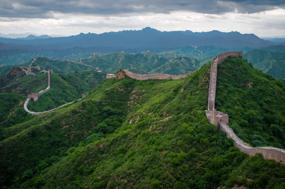
Quick Field Data
- UNESCO Inscription: Inscribed in 1987 (criteria i, ii, iii, iv, vi) across 2,151.55 hectares (with a 4,800.8-hectare buffer zone) along the historic northern frontier of China.
- Scale & Footprint: A 2012 National Cultural Heritage Administration survey documented 21,196.18 kilometres of total fortifications, including 8,850 kilometres of Ming Great Wall, 3,080 kilometres of Qin and Han walls, and 4,010 kilometres of Jin walls, comprising 10,051 wall sections, 1,764 trenches, 29,510 buildings, and 2,211 passes.
- Access & Ticketing: Restored mountain passes and wall sectors north of Beijing, at Shanhaiguan, and at Jiayuguan require timed entry tickets, with Badaling enforcing a 65,000 daily visitor cap; check the official site before visiting.
- Arrival Logistics: Easily reached via high-speed rail and suburban buses from Beijing to Badaling, Juyongguan, Mutianyu, and Jinshanling, or by rail to Shanhaiguan in Hebei and Jiayuguan in Gansu.
Stretching in a vast continental arc across northern China from Liaodong and the Bohai Sea in the east to Lop Lake and the Gansu desert corridors in the west, and from the Sino-Russian border in the north to the Tao River in the south, the Great Wall is the largest military defence system ever constructed by human hands. Begun during the Spring and Autumn and Warring States periods between the 8th, 7th, and 5th centuries BC when rival states, such as Qin, Zhao, Yan, Wei, Qi, Chu, Han, Lu, Zheng, Zhou, and Zhongshan, stamped earth and gravel between wooden frames to guard their borders, these regional barriers were linked into a unified northern frontier after Qin Shi Huang unified China in 221 BC and ordered northern defences against the nomadic Xiongnu around 220 BC. Rebuilt and extended across two millennia by the Han, Northern Wei, Northern Qi, Sui, Khitan Liao, Jurchen Jin (1115 to 1234), and Tangut Western Xia dynasties, the fortifications reached their monumental brick-and-stone climax under the Ming dynasty (1368 to 1644). Stone and earth follow the ridges. After 1987, the UNESCO World Heritage Atlas in 1987 across a 2,151.55-hectare core property and a 4,800.8-hectare buffer zone, the collective wall network was measured in a comprehensive 2012 survey by the National Cultural Heritage Administration at 21,196.18 kilometres in total length.
Beyond its purely military role of repelling Eurasian steppe cavalry and signalling troop movements via smoke and fire beacons, the Great Wall served as an elevated transport corridor, an immigration and customs barrier regulating Silk Road trade, and the physical boundary between settled agricultural China and the nomadic pastoral steppe. Recorded by the historian Sima Qian inside the Records of the Grand Historian under the "Long Wall" and cited by frontier general Tan Daoji in the AD 493 Book of Song as the "long wall of 10,000 li" (where one traditional Chinese mile equalled roughly 540 metres), the barrier was often called simply "frontiers" (Sai), "ramparts" (Yuan), "barriers" (Zhang), "outer fortresses", "border walls", "the Purple Frontier", or "the Earth Dragon" by post-Qin dynasties reluctant to invoke the First Emperor's conscription suffering, a human toll immortalised in Chinese literature such as Tch'en Lin's "Soldier's Ballad".
From Qin and Han Rammed Earth to the 8,850-Kilometre Ming Brick Frontier
Tracing the 21,196.18 kilometres documented in 2012, which encompass 2,211 fortresses and passes, 29,510 individual structures, 1,764 trenches, and 10,051 wall segments, with 31 percent located in Inner Mongolia and 19 percent in Hebei, reveals two distinct eras of military engineering. In the ancient Qin and Han sectors (totalling 3,080 kilometres) and the 4,010 kilometres of Jin walls (some northern stretches in the Gobi and Mongolian steppe colloquially dubbed the "Wall of Genghis Khan"), builders followed the principle of using local terrain and materials: stamping rammed earth and desert reeds in the plains and desert basins around Dunhuang's Yumen Pass, Yang Pass, and Mamitu, while stacking uncut fieldstone in mountain ranges. Curiously, 13th- and 14th-century visitors to Yuan China including Marco Polo, William of Rubruck, Odoric of Pordenone, Giovanni de' Marignolli, and Giovanni da Pian del Carpine never mentioned the eroded earthen walls, and although North African traveller Ibn Battuta around 1346 heard tales in Quanzhou (Zeitun) of Dhul-Qarnayn's rampart against Gog and Magog sixty days away, European accounts only began circulating in the 16th century through Portuguese and Spanish writers Gaspar da Cruz (1559), João de Barros (1563), Juan González de Mendoza (1585), Matteo Ricci, and Jesuit brother Bento de Góis, who entered China through the northwestern Jiayu Pass in 1605.
That 16th-century European awe reflected the massive reconstruction launched by the Ming dynasty after its mid-15th-century defeat by the Oirats at the Battle of Tumu. Abandoning the northern Yellow River loop to skirt the southern edge of the Ordos Desert from Yinchuan to Piantou Pass in Xinzhou, Shanxi, where the barrier splits into the Outer Great Wall along Inner Mongolia and a 400-kilometre Inner Great Wall running through Pingxing Pass and Yanmen Pass to rejoin at Sihaiye in Beijing's Yanqing County, and adding the mid-15th-century Liaodong Wall against Jurchen-Mongol Oriyanghan and Jianzhou Jurchens, Ming engineers created an 8,850-kilometre system composed of 6,259 kilometres of built wall, 359 kilometres of trenches, and 2,232 kilometres of natural cliff and river barriers (augmented in 2009 and 2015 by newly mapped sections in hills and along the Ningxia and Gansu border). Under General Qi Jiguang between 1567 and 1570 alone, 1,200 brick-faced watchtowers were erected between Shanhaiguan Pass and Changping out of an estimated 25,000 Ming towers in total. Using rectangular cut stone foundations and kiln-fired bricks bound with a resilient mortar of slaked lime mixed with sticky rice soup (and never human bones, despite popular myth), Ming masons topped the ramparts with battlements featuring 30-centimetre-tall by 23-centimetre-wide defensive crenels, internal drainage, stables, barracks, and high-ground signal towers, holding the heavily fortified Shanhai Pass ("First Pass Under Heaven") until Ming general Wu Sangui opened the gates on 25 May 1644 to ally with the Manchus against Li Zicheng's Shun rebels, ushering in the Qing dynasty (which discontinued border wall building in favour of the Willow Palisade).
Choosing Between Beijing's Mountain Ridges and the Terminal Passes
For travellers today, experiencing the Great Wall means selecting among very different landscapes along the 8,850-kilometre Ming line and the western desert passes. Around Beijing, the wall snakes across steep granite and limestone mountain crests: at Juyong Pass (Juyongguan), the stone-and-brick rampart measures 7.8 metres high and 5 metres wide; north of Juyongguan, Badaling was the first section opened to tourists and foreign dignitaries, drawing nearly 10 million visitors in 2018 before a daily cap of 65,000 was instituted in 2019; to the east, the 2.25-kilometre Mutianyu ridge links Juyongguan toward Gubeikou, while the 11-kilometre Jinshanling sector climbs razor-backed ridges in walls 5 to 8 metres high, 6 metres wide at the base, and 5 metres wide at the parapet, crowned by 67 watchtowers including Wangjing Lou at 980 metres above sea level. At the eastern terminus on the Bohai Gulf in Hebei, the "Old Dragon Head" at Shanhaiguan meets the sea just 3 kilometres south of the mountain wall at Jiaoshan and 15 kilometres southwest of the nine-arched river bridge wall at Jiumenkou, while at the western terminus in Gansu, the mud-brick fortress of Jiayu Pass (Jiayuguan) guards the Hexi Corridor.
- Select your Beijing ridge sector by crowd level and gradient: If you want accessible, fully restored ramparts with high-speed rail access, book one of the 65,000 daily slots at Badaling or visit Juyongguan; for steeper mountain photography along 67 watchtowers up to 980-metre Wangjing Lou, head to the 11-kilometre Jinshanling trail or the 2.25-kilometre Mutianyu ridge and check the official site for booking rules.
- Visit the eastern and western terminal fortresses: To understand the Great Wall as a continental system rather than a single ridge near Beijing, pair the sea-wall bastion of Old Dragon Head and Jiumenkou bridge at Shanhaiguan in Hebei with the desert fortress of Jiayuguan and the Han rammed-earth ruins of Yumen Pass in Gansu.
- Stay off unstabilised wild wall masonry: Outside managed tourist zones, 22 percent (1,961 kilometres) of the Ming wall has vanished and many towers are loose brick or eroding mud; never remove inscribed bricks or climb crumbling parapets.
Space Visibility Myths, Sandstorm Erosion, and Conservation Ethics
Few monuments have generated more folklore than the claim, first floated in a 1754 letter by English antiquary William Stukeley comparing Hadrian's Wall to the Chinese Wall, repeated by Henry Norman in 1895, and popularised by Ripley's Believe It or Not in 1932, that naked human eyes on the Moon can spot the Great Wall across an average orbital distance of 384,399 kilometres, a feat equivalent to spotting a human hair from 3 kilometres away. Even from low Earth orbit above 160 to 320 kilometres, astronauts Gene Cernan, Ed Lu, China's first astronaut Yang Liwei, and International Space Station photographer Leroy Chiao (alongside NASA and the European Space Agency) have confirmed that the narrow 5- to 6-metre stone-and-earth ribbon blends almost completely into the natural mountain contours except under rare, oblique lighting conditions.
On the ground, that intimacy between local stone, rammed earth, and harsh terrain creates severe conservation challenges. The 2012 National Cultural Heritage Administration report found that 1,961 kilometres (22 percent) of the Ming wall had already disappeared through weathering, village stone-quarrying, brick pilfering (once sold for 50 renminbi), and road or mining cuts, vividly illustrated in 2007 warnings that sandstorms could erase 60 kilometres of Gansu mud walls within 20 years, reducing 5-metre ramparts to under 2 metres, as well as a criticized 2014 concrete repair on the Liaoning and Hebei border and a 2023 incident in Shanxi where construction workers widened a gap with an excavator. Protecting the remaining 21,196.18 kilometres requires treating both the famous Ming brick battlements around Beijing and the fragile Han and Ming earthen ramparts of the western deserts as irreplaceable parts of a single historical landscape.
