


























Quick Field Data
- UNESCO Inscription: 1979 (following the Democratic Republic of the Congo's acceptance of the World Heritage Convention on 23 September 1974; later placed on the List of World Heritage in Danger) · Natural Criteria
- Scale & Footprint: 790,000 hectares spanning Lake Edward alongside the Rwindi and Rutshuru plus Semliki river valleys, seven of the eight Virunga massif volcanoes, and the 5,000-metre Monts Rwenzori
- Access & Ticketing: Administered by park authorities with mandatory ranger escorts and advance permits required for mountain gorilla tracking in the southern sector and crater ascents on Nyiragongo
- Arrival Logistics: Situated along the eastern frontier of the Democratic Republic of the Congo, spanning the southern volcanic plains up through Lake Edward and the Semliki Valley to the Rwenzori massif
Tectonic Crustal Extension and the Nyiragongo Lava Lake
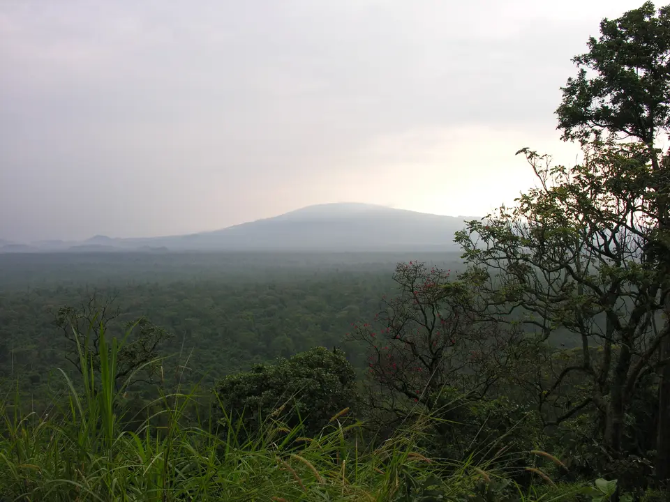
Virunga National Park encompasses 790,000 hectares along the eastern border of the Democratic Republic of the Congo, becoming the first of the country's five natural World Heritage Sites to be inscribed in 1979 after the nation accepted the 1972 UNESCO World Heritage Convention on 23 September 1974. No other national park on the African continent compresses such a dramatic latitudinal and altitudinal spectrum of habitats into a single contiguous corridor. Beginning in low-altitude equatorial marshlands, the eroded river valleys of the Ishango and Sinda regions, and open grass steppes around Lake Edward, the terrain climbs through dense low-altitude rainforest and afro-montane woodland zones up to active volcanic cones and the permanent snowfields and glaciers of the Monts Rwenzori, whose jagged reliefs and snowy summits culminate above 5,000 metres in elevation.
This extreme topographic relief is driven by active continental rifting and crustal extension along the western branch of the East African Rift. In the southern sector of the park, tectonic stretching of the earth's crust forced the emergence of the Virunga massif, a chain of eight volcanoes of which seven stand totally or partially inside the park boundaries. Dominating this volcanic skyline are Nyamuragira and neighbouring Nyiragongo, the two most active volcanoes in Africa. Combined, Nyamuragira and Nyiragongo are responsible for two-fifths of all historical volcanic eruptions recorded on the African continent, erupting at regular intervals every few years and carpeting the surrounding plains and savannah slopes in fresh volcanic rock and ash. Each eruption resets the ecological clock across the lower lava plains, where pioneer lichens, ferns, and shrubs gradually colonise the cooled basaltic flows while older volcanic cones remain cloaked in mature montane cloud forest.
Unlike typical viscous stratovolcanoes, the magma feeding both Nyamuragira and Nyiragongo consists of alkaline lava characterised by extreme fluidity. Within the summit crater of Nyiragongo, this hyper-fluid magma sustains a quasi-permanent lava lake at the bottom of the caldera, a rare global vulcanological phenomenon whose periodic drainage and crater breaches have historically unleashed fast-moving lava streams with catastrophic consequences for nearby local communities. At the opposite, northern end of the park, tectonic uplift pushed the non-volcanic crystalline block of Mount Rwenzori past 5,000 metres, where steep valleys and sheer cliffs transition from afro-alpine slopes of giant tree ferns and Lobelia up to permanent equatorial glaciers and snowfields that feed the Semliki watershed.
Mountain Gorilla Forests and Twenty Thousand Hippopotamuses
Because Virunga bridges active lava plains and central river savannahs with 5,000-metre glaciated peaks, its habitat mosaic generates exceptional species endemism and wildlife density across the rift valley. In the southern and central afro-montane and afro-alpine forests, cloaked in dense bamboo and tree ferns plus giant Lobelia across the steep volcanic slopes, live critically important populations of the globally threatened mountain gorilla alongside rare endemic primates and forest elephants plus montane birds. The steep altitudinal gradient on the extinct and dormant volcanoes allows gorilla family groups to forage seasonally between lower bamboo zones and higher sub-alpine slopes.
North of the volcanic lava plains, the park unfolds into the alluvial savannahs and steppes plus marshlands of the central rift basin. Here, the shores of Lake Edward and the winding channels of the Rwindi and Rutshuru alongside the Semliki River historically supported the largest concentration of hippopotamuses in Africa, numbering some 20,000 individuals living along the riverbanks and lake margins. These wallowing hippopotamus pods play a vital ecological role by fertilizing the aquatic food web of Lake Edward and maintaining open channels through the riverside swamps. Grazing across the adjacent savannah plains and the eroded valleys of the Ishango and Sinda sectors are major concentrations of African elephant and Cape buffalo alongside Thomas's cobs, while the equatorial wetlands and river corridors provide critical overwintering grounds for migratory birds arriving each northern winter from as far away as Siberia. Few places on earth bring migratory waterfowl from Siberia into the same protected watershed as equatorial forest elephants and hippopotamuses alongside high-altitude mountain gorillas.
Maintaining this 790,000-hectare sanctuary has required constant vigilance against severe environmental and security pressures. Across the Democratic Republic of the Congo, all five World Heritage Sites were inscribed for their natural significance under criteria vii through x, while the country also maintains five properties on its tentative list. Under the 1972 World Heritage Convention, natural heritage encompasses physical and biological formations alongside geological and physiographical features and critical plant and animal habitats of highest value for science and conservation. Four of the five inscribed sites in the country are currently listed on the List of World Heritage in Danger due to armed conflict and wildlife poaching plus deforestation, while the fifth, Salonga National Park, was listed as endangered from 1999 until 2021. In Virunga, charcoal deforestation on the volcanic foothills and poaching along the Lake Edward and Rwindi plains alongside periodic catastrophic lava lake eruptions from Nyiragongo demand intensive ranger protection and international conservation support to safeguard both the mountain gorilla families and the local communities living along the park boundary. Ranger patrols work daily across the southern bamboo forests, the central Rwindi and Rutshuru savannahs, and the northern Semliki valley to monitor wildlife populations and protect the park's boundaries against illegal resource extraction.
Tracking Mountain Gorillas and Ascending the Nyiragongo Crater Rim
Visiting Virunga National Park requires checking current field security advisories and booking ranger-escorted permits through park headquarters to explore the southern volcanic massif, the central river plains, or the northern Rwenzori trails. The lava lake glows red. Moving from the humid equatorial forests of the Semliki basin up to the freezing crater rim of Nyiragongo or the snowfields of Mount Rwenzori reveals why this rift valley corridor preserves more distinct habitat zones than any other park in Africa. Because road conditions and access protocols vary across the 790,000-hectare reserve, every excursion is coordinated directly with park authorities and accompanied by trained rangers.
- Entry and Route into the Southern Virunga Volcanoes: Enter the southern sector of the park with an accredited park ranger patrol to trek through the dense afro-montane forests clothing the slopes of the seven Virunga massif volcanoes. Follow trackers along bamboo and tree-fern paths to spend a strictly regulated hour observing habituated mountain gorilla groups in their high-altitude forest habitat beneath the volcanic cones, keeping a safe distance to protect the apes from human-borne illness.
- Tickets, Interiors and Viewpoints on Nyiragongo and the Rwenzori: Experienced trekkers with a separate volcano permit ascend the steep solidified alkaline lava flows of Nyiragongo to camp on the high crater rim and look directly down into the churning quasi-permanent lava lake at the bottom of the caldera, where molten basalt rises and falls inside the sheer volcanic walls. Farther north beyond the eroded panoramas of the Ishango and Sinda valleys, multi-day alpine expeditions climb through giant Lobelia and tree-fern zones toward the 5,000-metre snowy summits and permanent equatorial glaciers of Mount Rwenzori above the Semliki River watershed.
- Timing and Onward Connections along Lake Edward and the Semliki: Schedule forest tracking and volcano ascents during the drier months when steep volcanic and alpine paths are less slippery, or visit during the northern winter months when migratory birds from Siberia congregate along Lake Edward and the Rwindi and Rutshuru plus Semliki rivers alongside hippopotamus pods and elephants plus buffalo and Thomas's cobs. Compare Virunga's rift-valley ecosystems and active alkaline volcanoes plus glaciated equatorial massifs with neighbouring African reserves in our UNESCO World Heritage Atlas as you plan your journey across the Democratic Republic of the Congo.
