


























Quick Field Data
- UNESCO Inscription: 1984, inscribed as the sole surviving inland commercial palace-city and urban planning ensemble of the Umayyad Caliphate in Lebanon.
- Scale & Footprint: Encompasses a walled rectangular enclosure measuring approximately 370 by 310 metres (114,000 square metres, or 385 by 350 metres including outer defenses) in the Beqaa Valley.
- Access & Ticketing: Managed as a fenced pedestrian archaeological park on the edge of modern Anjar; check the official site for seasonal entry details.
- Arrival Logistics: Located in the Zahle District of the Beqaa Valley near the Syrian border, positioned along the historic highway linking Beirut and Damascus.
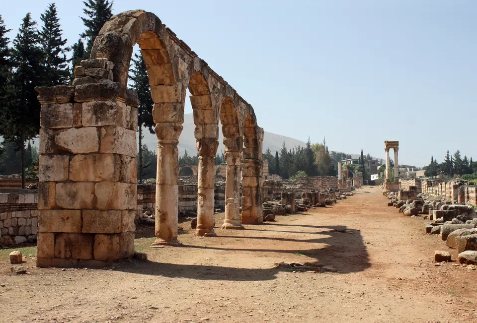
Set on the flat alluvial floor of the central Beqaa Valley at the foot of the eastern mountain range, the archaeological ruins of Anjar preserve a rare, single-period snapshot of early Islamic urban planning. Unlike coastal cities in Lebanon where thousands of years of continuous habitation stacked one civilisation directly atop another, Anjar was founded on virgin soil at the beginning of the eighth century AD and abandoned less than forty years later. Since 1984, the UNESCO World Heritage Atlas in 1984, this walled Umayyad foundation combines the orthogonal geometry of a classical Roman castrum with the residential palaces, mosque, thermal baths, and commercial arcades of the Damascus Caliphate. Tall stone arcades frame the valley floor.
Caliph Walid, Commercial Crossroads, and the Battle of 744
Historical chronicles and archaeological evidence date the construction of Anjar to the reign of the Umayyad Caliph Walid Ibn Abd Al-Malak (al-Walid I, reigned 705 to 715 AD). Syriac stonecutters' graffiti discovered in the nearby limestone quarry from which the best building stone was extracted record the year 714 AD, and the Byzantine chronicler Theophanes the Confessor wrote that it was the caliph's warrior son al-Abbas, who initiated construction of the settlement in 709 AD. Known also in Arabic as Hawsh Mousa, the settlement takes its name from the running freshwater springs emerging at the base of the adjacent mountain slope that still supply water across the twenty-square-kilometre municipal area.
The Umayyad princes selected this inland location because it commanded the intersection of two vital trade arteries: one leading across the mountain passes from the Mediterranean port of Beirut to the Umayyad imperial capital of Damascus, and the other crossing the Bekaa from Homs in central Syria down toward Tiberiade. Designed simultaneously as a princely seasonal retreat and an inland commercial centre, the fortified settlement provided secure warehousing and market stalls alongside administrative courts for merchant caravans traversing the interior.
Anjar's existence proved brief and construction across the city was never fully completed. During the dynastic civil wars that fractured the Umayyad caliphate during that decade, the rival Umayyad army marched against Caliph Ibrahim, son of Walid. In 744 AD, Caliph Ibrahim was defeated in battle outside Anjar, and the partially destroyed palace-city was subsequently abandoned. For more than twelve centuries the orthogonally planned enclosure remained largely deserted beneath earth mounds until archaeologists rediscovered and began excavating the fortified city at the end of the 1940s, revealing its intact eighth-century street grid and palace walls.
Orthogonal Quadrants, the Tetrapylon, and the Grand Umayyad Palace
The architectural footprint of Umayyad Anjar forms a strictly regular rectangle covering 114,000 square metres (measuring 370 by 310 metres inside the walls, or 385 by 350 metres across the exterior perimeter). The fortified stone enclosure wall, built over two metres thick and rising seven metres high, is flanked by forty projecting defensive towers spaced evenly along the ramparts and pierced by four monumental gates facing the cardinal directions. Inside the perimeter, stone staircases gave garrison sentries access to the upper rampart walk.
Connecting the four porticoed city gates are two wide colonnaded avenues modelled directly on Roman city planning: a primary north-south axis (the Cardo Maximus) and a lesser perpendicular east-west axis (the Decumanus Maximus). Superposed directly above the main underground masonry collectors for sewers that drained waste water out of the enclosure, these two thoroughfares divide the walled city into four equal quadrants. Where the two main avenues intersect at the exact geometric centre of the city stand the four dramatic four-columned podiums of a monumental tetrapylon (tetrapyle), whose plinths and shafts alongside capitals are Roman architectural spolia reused by Umayyad builders.
Along both sides of the two intersecting colonnaded avenues stretched vaulted porticos flanked by about 600 small commercial shops, confirming the settlement's role as an inland market emporium. Public and private buildings were distributed across the four quadrants according to a strict functional plan. The prestigious southeastern quadrant, occupying the highest ground of the site, houses the partially rebuilt Grand Palace of the Caliph (measuring 59 by 70 metres) and the Friday Mosque (measuring 45 by 32 metres) immediately between the two palaces. Preserved and reconstructed up to three levels along its courtyard arcades, the Grand Palace is preceded by a series of arches and organised around a central courtyard (hosh) surrounded by a peristyle. Its walls borrow Byzantine stonework techniques, alternating horizontal courses of dressed limestone blocks and thin layers of baked brick, while displaying exceptional eighth-century carved stone reliefs of acanthus leaves and vine scrolls alongside geometric motifs.
Directly across the eastern avenue in the northeastern quadrant stands the almost square Small Palace (measuring 46 by 47 metres), identified as the harem or secondary princely residence, which stands out for its numerous ornamental stone fragments and its richly decorated central entrance. Also located in the northeastern quadrant near the northern gate are the thermal baths, built on the classical Roman model with cold and warm alongside steam-heated rooms and positioned on the downhill side of the enclosure so that bathhouse waste water could drain efficiently outside the ramparts. Meanwhile, secondary functions and living quarters were distributed across the northwestern and southwestern quadrants, where smaller streets subdivided the western half of the city into residential housing blocks of varying size.
Modern Musa Dagh Settlement and Walking the Colonnaded Cardo
After remaining abandoned for centuries, the land beside the Umayyad ruins welcomed several thousand Armenian families from Musa Dagh who settled here in 1939. The residents organised their new town into six neighbourhoods named after the six ancestral Musa Dagh villages (Vakif, Kebusiyeh, and Haji Habibli, as well as Kheder Bek, Yoghunoluk, and Bitias). In the 1940s and the following decade, the community established the Saint Paul Armenian Apostolic Church and the Haratch Calouste Gulbenkian school (established in 1941 following a 1940 Paris fundraising appeal), alongside the Armenian Catholic parish of Our Lady of the Rosary and the Armenian Evangelical Church school established in 1948. In November 2024, UNESCO granted the archaeological site of Anjar enhanced protection to safeguard the ruins against damage during the conflict in Lebanon.
Because Anjar was laid out in a single early eighth-century campaign and never overbuilt by later medieval cities, its stone enclosure walls and colonnaded avenues preserve the clarity of an Umayyad architectural blueprint. From the four-columned central tetrapylon to the alternating brick-and-limestone arcades of the Grand Palace, the mosque, the baths, and the 600 market shops lining the intersecting thoroughfares, the site illuminates how early Islamic patrons adapted classical urban geometry to serve an inland commercial and princely centre in the Beqaa Valley.
Walking the perimeter of the stone ramparts and looking across the four quadrants shows how carefully the eighth-century engineers integrated water supply, waste drainage, commercial traffic, and princely privacy within a single rectangular wall. Every shop stall along the main avenues and every carved stone capital inside the palace courtyards reflects the brief moment when Umayyad patrons brought classical urban order to the floor of the Bekaa Valley. Because the archaeological park of Anjar sits on flat valley terrain with wide stone avenues, it offers an exceptionally clear walking circuit.
- Begin at the western gate and walk to the tetrapylon: Enter along the east-west avenue to observe how the shop-lined colonnades frame the central four-piered tetrapylon against the backdrop of the surrounding mountains.
- Inspect the stone and brick courses at the Grand Palace: Walk into the southeastern quadrant to examine the three preserved levels of the Grand Palace arcade, where reused Roman capitals meet eighth-century Umayyad carved stone decor and alternating brick-and-stone masonry.
- Trace the water system from the mosque to the north baths: Follow the north-south Cardo Maximus from the mosque between the palaces to the northeastern thermal baths, where Roman heating chambers and drainage channels remain visible at ground level.
