


























Quick Field Data
- UNESCO Inscription: 1984, designated for continuous habitation since the Neolithic era and its role in diffusing the linear Phoenician alphabet.
- Scale & Footprint: Occupies a coastal sandstone cliff and medieval walled town (270 metres east-to-west by 200 metres north-to-south) within a 4.16-square-kilometre municipality.
- Access & Ticketing: Visitor access enters near the Crusader citadel on the edge of the historic souq; check the official site for current admission arrangements.
- Arrival Logistics: Located on the Mediterranean coast roughly 40 to 42 kilometres north of Beirut in the Keserwan-Jbeil Governorate.
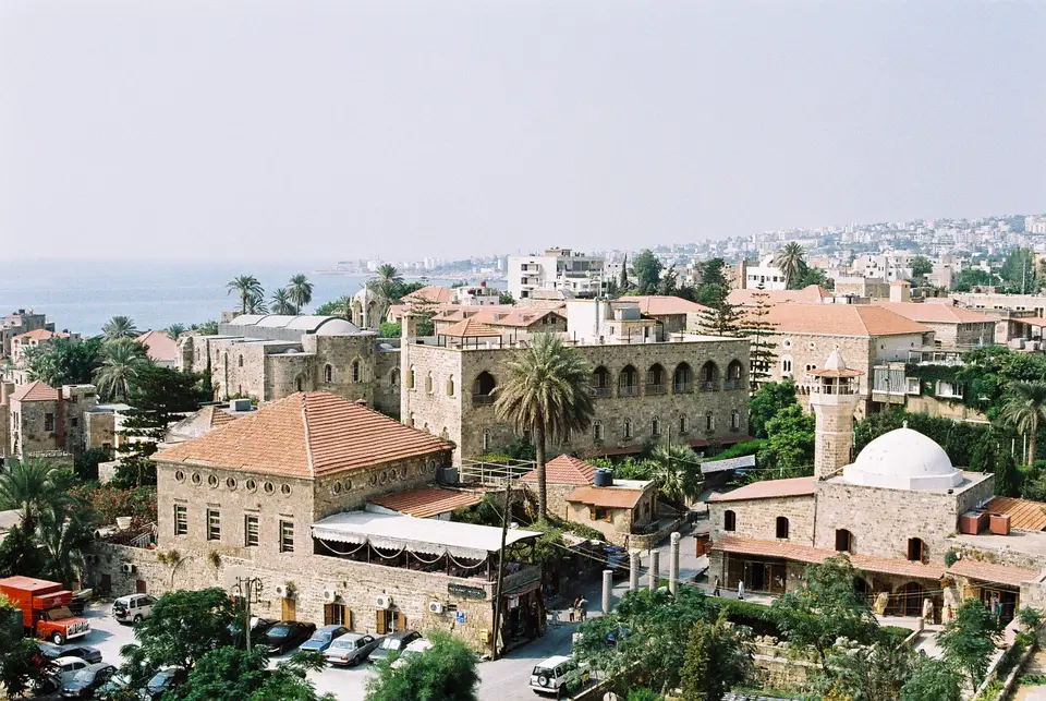
Perched on a sandstone cliff overlooking a sheltered Mediterranean cove roughly 40 kilometres north of Beirut, Byblos (known in Arabic as Jbeil, Jbail, or Jubayl) is one of the oldest continuously inhabited cities on the planet. In 1984, the UNESCO World Heritage Atlas in 1984, the archaeological tell and adjacent medieval town expose an unbroken sequence of human settlement stretching back more than 8,000 years, from a Pre-Pottery Neolithic fishing community settled between 8800 and 7000 BC to a fortified Bronze Age timber port, Roman civic sanctuary, Crusader lordship, and Ottoman market town. Beyond its deeply stratified physical ruins, Byblos holds a foundational place in human literacy as the site where the earliest monumental inscriptions of the 22-character Phoenician linear alphabet were discovered. Ancient stone walls overlook the harbour.
Sacred Wells, Egyptian Cedar Trade, and the Ahiram Alphabet
In antiquity, the local Phoenician population knew the city as Gebal (derived from gb and el, meaning Well of the God, or alternatively the sacred Source), while Egyptian hieroglyphic records going back to the fourth-dynasty pharaoh Sneferu (around 2600 BC) refer to the port as kbnj, and fourteenth-century BC Akkadian cuneiform tablets from the Amarna letters to Amenhotep III and IV call it Gubla. Because the city functioned as the primary Mediterranean port for importing papyrus out of Ancient Egypt into the Greek world, the Greeks used the name Byblos to mean papyrus, and the English word Bible derives from the Greek name of this coastal town.
Archaeological excavations initiated by Ernest Renan in 1860, expanded by Pierre Montet between 1921 and 1924, and directed by Maurice Dunand for a span of forty years beginning in 1925 revealed how a settlement of rectangular Neolithic dwellings with white plastered floors (covering 1.2 hectares on the seaward slope) evolved around 3000 BC into a proto-urban town centred on the natural spring of Ain el-Malik (the King's Spring). Measuring roughly 20 metres deep and accessible by spiral stairs, this large cavity once supplied the city with water and features in the classical account by Plutarch regarding the Osiris myth as the place where Isis met the royal servants before discovering the chest of Osiris concealed inside a wooden column of the royal palace. Throughout the Old, Middle, and New Kingdoms of Egypt, Byblos acted as a wealthy maritime ally of the pharaohs, supplying cedar timber for First Dynasty tombs and oceangoing "Byblos ships" while receiving objects naming rulers such as Khasekhemwy, Senusret II, and Neferhotep (Neferhotep I, thirteenth dynasty). Around 1350 BC, King Rib-Hadda of Byblos and his successor Ili-Rapih dispatched 60 cuneiform letters preserved in the Amarna archive pleading for Egyptian military assistance.
When the Egyptian New Kingdom collapsed in the eleventh century BC, Byblos emerged as the foremost city of early Iron Age Phoenicia. Five Byblian royal inscriptions dating between roughly 1150 and 950 BC demonstrate the use of a phonetic Phoenician alphabet of 22 characters, which Phoenician merchants spread through maritime trade across North Africa and Europe. The most important example is carved on the sarcophagus of King Ahiram, discovered inside the royal necropolis shafts of the acropolis.
Bronze Age Temples, Royal Shaft Tombs, and the Crusader Castle
Walking through the open-air archaeological park today allows visitors to traverse multiple millennia of sacred and military architecture within a single coastal promontory. Across Lebanon, the core of ancient tell sit the stone foundations of the monumental Bronze Age sanctuaries: the Temple of Baalat Gebal and the L-shaped Temple erected about 2700 BC. Originally built between 1600 and 1200 BC directly on top of the L-shaped Temple, the Obelisk Sanctuary (honouring the Canaanite war deity Resheph) was moved by archaeologists to its present adjacent location so both levels could be inspected. Within this sanctuary stand dozens of small stone obelisks erected as religious offerings, where excavations recovered a large collection of bronze human figurines covered with gold leaf that now reside within the National Museum collection in Beirut.
Along the western seaward edge of the cliff, deep vertical shafts cut into the rock form the Royal Necropolis of the second millennium BC, housing the subterranean burial chambers of the Byblos kings including King Ahiram, complemented by a Bronze Age burial ground for the Gebalite elite unearthed in 2019 on the southern outskirts of the acropolis. Nearby sits a small Roman theatre built around AD 218, relocated toward the sea cliff alongside remnants of the Roman road and Persian fortifications.
Dominating the entrance to the archaeological precinct is the twelfth-century Byblos Castle, built by the Crusaders inside the fortified town known in Western records as Gibelet or Giblet. As part of the Crusader County of Tripoli, Gibelet was governed by the Genoese Embriaco family, who created the Lordship of Gibeletto and used the castle as their residence and military base. Taken by Saladin in 1187, retaken by the Crusaders, and conquered by the Mamluk sultan Baibars in 1266 (who subsequently restored its fortifications), the castle stands beside the medieval intra-muros town enclosed within ramparts spanning roughly 270 metres east-west by 200 metres north-south. Inside the historic quarter stand the Crusader Church of Saint John the Baptist (begun in 1115 and partially damaged in the earthquake of AD 1170 before being given to the Maronite bishop by Prince Yusuf Shihab), the Mamluk Sultan Abdulmejid Mosque (renovated under Sultan Abdulmejid I,), the historic souks, the Byblos Wax Museum, the Byblos Fossil Museum, and the Aram Bezikian Museum.
Harbour Conservation and Exploring the Stratified Cliff
Protecting the fragile sandstone and limestone ruins of Byblos requires continuous consolidation against coastal erosion and urban development around its ancient port. After the 2006 Lebanon War stained the ancient harbour and coastal ramparts with spilled fuel oil from a nearby power plant, conservation teams cleaned the stonework, and during the 2024 conflict UNESCO placed Byblos alongside 33 other Lebanese heritage sites under enhanced protection while an exhibition of 400 artefacts from the city was organised in Paris at the Institut du monde arabe during 2026.
Few coastal sites anywhere in the Mediterranean compress as many distinct historical epochs into a single walkable promontory as Byblos. Within a few hundred metres of the natural spring of Ain el-Malik, visitors can look down onto the white plastered floors of Neolithic fishermen's dwellings, walk between the third- and second-millennium BC foundations of the Baalat Gebal and Obelisk sanctuaries, peer into the deep rock-cut shafts where King Ahiram's alphabetic sarcophagus rested, and climb the limestone ramparts of a twelfth-century Crusader castle overlooking the ancient timber-exporting port.
Standing on the elevated ramparts of the Crusader keep and looking out across the grass-covered tell toward the sea allows visitors to read this entire chronological sequence in a single sweep. Below the medieval moat lie the circular and rectangular stone foundations of the earliest fishing village, the spring that sustained Bronze Age timber ships bound for Egypt, and the limestone shafts that sheltered the royal tombs of Phoenician kings. Exploring the citadel, open-air tell, historic churches, and medieval harbour takes two to three hours on foot.
- Climb the Crusader keep first for site orientation: Start your visit by climbing to the top of the twelfth-century Byblos Castle, which offers a clear view over the Temple of the Obelisks, the 20-metre-deep Ain el-Malik spring cavity, the Royal Necropolis shafts, and the AD 218 Roman theatre by the sea.
- Follow the footpaths through the Neolithic and Bronze Age levels: After descending from the castle, follow the signposted path down past the Persian and Hellenistic ramparts to inspect the rectangular Neolithic house foundations with their plastered floors and the L-shaped Temple of 2700 BC.
- Stroll from Saint John the Baptist Church to the ancient port: Exit the archaeological gate through the old market souks to visit the 1115 Crusader Church of Saint John the Baptist, then walk down to the harbour basin where yachts and fishing boats moor today.
