


























Quick Field Data
- UNESCO Inscription: 1984, recognised for its role in Phoenician maritime history and its extensive Roman and Byzantine architectural remains.
- Scale & Footprint: Encompasses two main archaeological zones (the coastal island city site and the Al-Bass mainland necropolis and hippodrome) on the headland of southern Lebanon.
- Access & Ticketing: Divided into two fenced archaeological parks located inside the modern coastal city of Sour; check the official site for entry requirements and conservation zone access.
- Arrival Logistics: Situated on the Mediterranean coast approximately 80 kilometres south of Beirut, reached via the coastal highway passing Sidon.
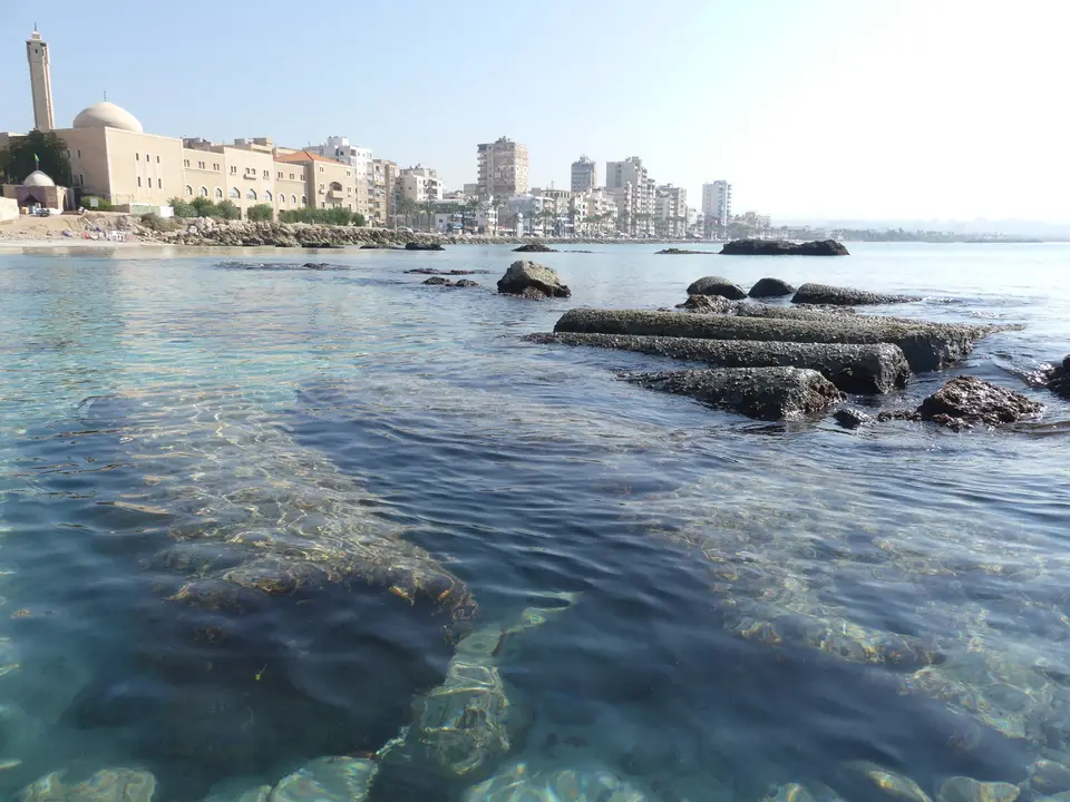
Jutting into the eastern Mediterranean from the southern coast of Lebanon, the ancient city of Tyre (known in Arabic as Sour) was one of the preeminent maritime powers of the ancient world. For Lebanon, the UNESCO World Heritage Atlas in 1984, the city originated as a twin settlement pairing a mainland coastal town (Ushu or Palaetyrus) with a heavily fortified offshore rock island. Only in 332 BC, when Alexander the Great constructed a monumental stone and timber causeway across the sea channel during a seven-month siege, was the island permanently joined to the mainland. Over subsequent centuries, marine silt accumulated on both sides of Alexander's mole, transforming the ancient island into the broad sandy peninsula that frames modern Tyre and its twin archaeological precincts. Waves still break over submerged harbour stones.
Phoenician Thalassocracy, Tyrian Purple, and Alexander's Causeway
According to the Greek historian Herodotus, priests at the city's main sanctuary informed him that Tyre had been founded around 2750 BC. Archaeological excavations on the island have confirmed continuous human habitation stretching back to at least the third millennium BC, while fourteenth-century BC cuneiform letters from Egypt record correspondence from the ruler of Tyre regarding water and wood alongside mainland territory. During the tenth century BC, King Hiram (Hiram I, king of Tyre) forged a celebrated commercial alliance with Kings David and Solomon of Israel, supplying prized cedar timber and skilled craftsmen while joining the offshore reefs of the island into a unified urban platform equipped with two sheltered harbours.
From its dual ports, consisting of the northern Sidonian harbour and the southern Egyptian harbour, Tyrian merchant fleets navigated the entire Mediterranean basin and ventured out into the Atlantic. Seeking silver and tin alongside trade monopolies, Tyre established a far-flung network of overseas trading colonies across Cyprus, southern Iberia and the western Mediterranean, and North Africa, most famously founding the city of Carthage in modern Tunisia under the legendary princess Dido (Elissa). Alongside its maritime commerce, the city derived immense wealth from extracting prized purple dye from marine murex snails, a luxury pigment reserved for royalty and ceremonial garments that gave rise to the colour name Tyrian purple and the Greek name Phoenicia itself.
Although the island fortress withstood protracted mainland sieges by Eastern armies, its insular invulnerability ended with the arrival of Alexander the Great in 332 BC. Lacking a naval fleet initially, Alexander demolished the abandoned mainland ruins of old Tyre to build a 1-kilometre stone causeway across the water toward the island walls, eventually breaching the fortifications with ship-mounted siege engines after seven months. Despite the devastation of the siege, Tyre recovered rapidly under Hellenistic and Roman rule, receiving the status of a Roman metropolis before serving as an early Christian archbishopric and later a fortified stronghold of the Crusader Kingdom of Jerusalem until its capture by the Mamluk Sultanate in the late thirteenth century.
The Island Civic Precinct and the Al-Bass Necropolis and Hippodrome
Today, the physical heritage of classical and medieval Tyre is concentrated within two primary archaeological zones: the coastal city excavations on the southern tip of the ancient island and the inland Al-Bass site on the neck of the peninsula. At the coastal island site, a broad Roman and Byzantine colonnaded avenue paved in marble flagstones and geometric floor mosaics slopes directly down toward the submerged breakwaters of the ancient Egyptian harbour. Flanked by monolithic columns of green cipollino marble, this civic thoroughfare passes residential quarters, cistern complexes, public Roman baths (thermae) supported by brick hypocaust pilae, and a unique rectangular arena surrounded by five concentric tiers of stone seating that functioned for spectacles or civic assemblies.
Near the northern edge of the island precinct stand the lower foundations and fallen red granite columns of the twelfth-century Crusader cathedral. Built over an earlier mosque and possibly the site of the city's ancient central temple, this medieval church hosted royal Crusader ceremonies and received the remains of the Holy Roman Emperor Frederick Barbarossa during the Third Crusade. Offshore along the southern and northern coastlines of the peninsula, submerged Phoenician and Roman harbour moles, wave-breaker quarries, and ancient shipwrecks form an extensive underwater archaeological reserve just beneath the surface of the sea.
Roughly one kilometre east on the mainland isthmus lies the Al-Bass archaeological zone, which formed the monumental eastern entrance to the classical city. Visitors enter along a wide funerary street lined with hundreds of ornate marble and local limestone sarcophagi dating from the second to fifth centuries AD, many carved with mythological bas-reliefs alongside Greek inscriptions naming local purple-dye artisans and merchants. Rising above the necropolis is a reconstructed three-bay Roman triumphal arch built of local sandstone in the second century AD, flanked by the stone piers of a perennial aqueduct that carried fresh water from the Ras el-Ain artesian springs six kilometres south. Immediately south of the arch stretches the Roman hippodrome of Tyre, one of the largest and best-preserved Roman chariot-racing circuses in the world, once capable of seating around 20,000 spectators around its central spina and granite obelisk.
Conservation Challenges and Walking the Twin Archaeological Parks
Preserving Tyre's multi-layered urban landscape has required navigating decades of modern urbanisation and regional conflict. Following systematic mid-twentieth-century excavations that uncovered the hippodrome and colonnaded streets, the outbreak of the Lebanese Civil War in 1975 disrupted site maintenance and spurred unregulated building around the ancient precincts, prompting UNESCO to inscribe Tyre in 1984 to encourage protective zoning. In 1998, the adjacent Tyre Coast Nature Reserve, a 380-hectare sandy beach and freshwater spring zone where endangered loggerhead and green sea turtles nest, was designated a Ramsar wetland. During the 2006 war and again during the 2024 conflict in Lebanon, nearby strikes threatened historic fabric, leading UNESCO to grant Tyre enhanced international protection in November 2024.
Across both the seaward tip of the peninsula and the mainland approach at Al-Bass, the surviving stonework of Tyre illustrates how a compact island fortress evolved into a monumental classical and medieval port city. Marble colonnades, public bathhouses with brick heating pillars, cistern networks, and the vast stone seating tiers of the Roman circus reflect centuries of prosperity rooted in Mediterranean commerce and purple-dye production. Set beside the active fishing harbour and the protected sandy beaches of the coastal nature reserve, the twin archaeological zones preserve the physical imprint of Phoenician, Roman, Byzantine, and Crusader history along the southern shore of Lebanon.
Walking between the coastal peninsula and the mainland isthmus also highlights how geography shaped the survival of ancient monuments across different centuries. Where the seaward colonnades and harbour moles absorbed the full force of Mediterranean winter storms and shifting shoreline sands, the inland necropolis and chariot arena were gradually covered by deep alluvial soil that protected their carved limestone and marble surfaces. Exploring both archaeological zones alongside the historic Christian and Ottoman harbour alleys takes roughly half a day on foot. Because both archaeological parks are open-air stone expanses with minimal shade, structuring the walk around the coastal breeze makes the visit far more comfortable.
- Divide the visit between both sectors: Begin early at the expansive Al-Bass necropolis and hippodrome before midday heat builds on the exposed limestone tracks, then walk or take a short local taxi ride west to the coastal island ruins and the old fishing port.
- Examine the sarcophagus carvings and mosaics: Look closely at the carved marble sarcophagi lining the Al-Bass funerary avenue and the geometric floor mosaics preserved beneath the marble columns at the coastal site.
- Combine ruins with the historic fishing harbour: After touring the island excavations, stroll north along the waterfront alleys of the old Christian quarter to view the Ottoman khan, nineteenth-century townhouses, and wooden fishing boats moored inside the ancient Sidonian harbour basin.
