


























Quick Field Data
- UNESCO Inscription: 1988 under cultural criteria i, ii, iii, v, and vi across 68.02 hectares with a 154.36-hectare buffer zone in central Tunisia.
- Scale & Footprint: Serial property comprising the walled medina (54 ha) and suburbs (20 ha), the Great Mosque of Uqba, the 866 Mosque of the Three Doors, the 9th-century Aghlabid Basins, and the Zawiya of Sidi Sahib.
- Access & Ticketing: Medina streets and souks are open to pedestrians; check official heritage ticket counters for admission to the Great Mosque courtyard, Aghlabid Basins, and Zawiya.
- Arrival Logistics: Located at 68 metres elevation 50 km west of Sousse, 75 km from Monastir, and 184 km south of Tunis.
Set in a central Tunisian plain at an elevation of 68 metres at an almost equal distance from the Mediterranean Sea and the mountain range, Kairouan (also spelled Kairwan or El Qayrawan) is the most ancient Arabo-Muslim base in the Maghreb and one of its principal holy cities. From 1988, the UNESCO World Heritage Atlas in 1988 across 68.02 hectares with a 154.36-hectare buffer zone, the serial property encompasses the medina (54 hectares) and its surrounding suburbs (20 hectares) alongside the 9th-century Aghlabid water cisterns and the revered Zawiya of Sidi Sahib. Serving as the capital of Ifriqiya for five centuries, the city counted 187,000 inhabitants in 2014 and 210,313 in 2022. White domes rise above the plain.
Foundation in 670 AD, Berber Wars, and the Aghlabid Golden Age
The Arabic name al-Qayrawan derives from the Middle Persian word karawan, meaning a military column, outpost, or caravan (adapted into Berber as Tikirwan and romanised in early modern English as Cairoan). Around the year 670 CE, during the reign of Umayyad Caliph Mu'awiya (reigned 661 to 680), the Arab general Uqba ibn Nafi selected the site of the former Byzantine garrison of Kamounia, set inside a dense forest far from the sea to remain safe from coastal attacks, as a garrison camp supporting the westward military campaign. Fierce Berber resistance followed, headed initially by Kusaila (whose forces slew Uqba at Biskra roughly fifteen years later) and then by the Berber leader Al-Kahina, who was defeated and killed in 702, followed by mass conversion of the Berbers to Islam and the emergence of Kharijite communities.
During the Great Berber Revolt in October 741, after the Ifriqiyan army under Kulthum ibn Iyad al-Qasi was destroyed at the Battle of Bagdoura and his nephew Balj ibn Bishr al-Qushayri was isolated in Spain, Umayyad Caliph Hisham named Handhala ibn Safwan to govern Ifriqiya. Leaving Egypt under governor Hafs ibn al-Walid in February 742, Handhala gathered troops from Barqa (Cyrenaica) and Tripoli (Tripolitana) and reached Kairouan in April 742, where the qadi the local qadi Abd al-Rahman ibn Oqba had been defending the city against Sufrite rebel leader Oqasha ibn Ayub al-Fezari. Handhala defeated Oqasha at El-Qarn and then armed the entire population of Kairouan in May 742 to defeat the 300,000-strong rebel forces under Abd al-Wahid ibn Yazid al-Hawwari at al-Asnam just three miles outside town, where 120,000 to 180,000 rebels fell. After Kharijite Berbers captured the city in 745, Ibrahim ibn al-Aghlab retook Kairouan toward the close of the 8th century.
In 800, Abbasid Baghdad Caliph Harun ar-Rashid recognized Ibrahim ibn al-Aghlab as hereditary emir, founding the Aghlabid dynasty that ruled Ifriqiya until 909. Matching Basra and Kufa in prosperity, the Aghlabids conquered Sicily in 827, received ambassadors dispatched by Charlemagne and the Holy Roman Empire, and transformed the Great Mosque into a university comparable to the medieval University of Paris, where Imam Sahnun and Asad ibn al-Furat taught Maliki Islamic sciences alongside secular disciplines. Simultaneously, from the late 8th to the early 11th century, Kairouan's Jewish community thrived for three generations as a world centre of Talmudic and Halakhic scholarship. After the Kutama Berbers and Abdullah al Mahdi launched the Shiite Fatimid movement in 893 and overthrew the Aghlabids in 909, the Fatimids moved their capital to Raqqada, Al Mahdiyah, and finally Cairo, leaving the Zirids as vassals in Kairouan. When the Zirids declared independence from Cairo and returned to Sunni allegiance in 1045, the Fatimid ruler Ma'ad al-Mustansir Billah dispatched the nomadic Banu Hilal and Banu Sulaym tribes, who captured and devastated Kairouan in 1057, a ruin described in the 12th century by geographer Al-Idrisi alongside the ruined royal city of Sabra (which once held three hundred baths) and its two-hundred-cubit square cistern (majel). After the political capital shifted to Tunis during the 12th century, Kairouan revived under the 13th-century Hafsids and the later Muradid and Husainid dynasties. In 1881 French forces occupied the city, opening it to non-Muslims and building the 600-millimetre Decauville railway between Sousse and Kairouan, which operated from 1882 to 1996 before regauging to 1,000 millimetres.
The Great Mosque, Three Doors Façade, and Aghlabid Basins
Surrounded by ramparts extending over more than three kilometres (where 30 metres of masonry beside the Gate of the Leather Workers fell while undergoing restoration in December 2023), the 54-hectare medina and 20-hectare suburbs contain 89 mosques (as of 2004) and four flagship World Heritage monuments:
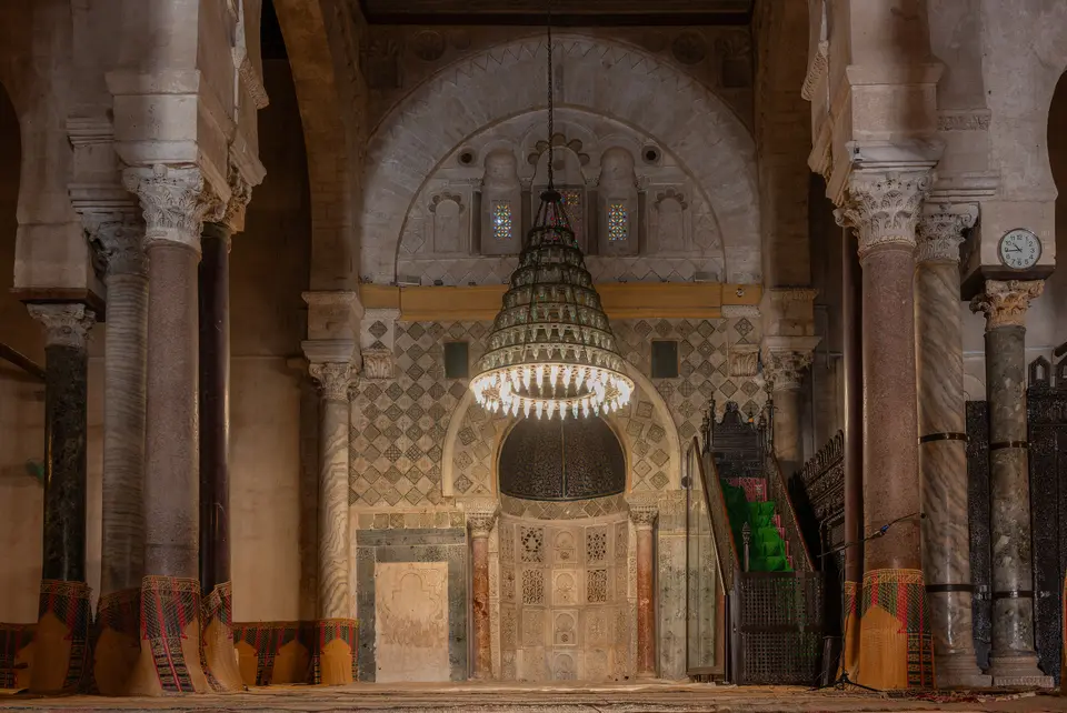
- Great Mosque of Kairouan (Mosque of Sidi-Uqba): Originally built in 670 AD and covering more than 9,000 square metres (97,000 square feet), featuring marble and porphyry columns and serving as an architectural model for Maghreban mosques and a historic university under the Maliki current.
- Mosque of the Three Doors: Founded in 866 AD, preserving the oldest extant sculpted façade in Muslim art, pierced by three arched doorways topped by three Kufic inscriptions (the first quoting verses 70 to 71 of Sura 33 of the Quran), floral and geometric reliefs, a carved frieze, a three-aisle prayer hall parallel to the qibla wall, and a small Hafsid minaret.
- Zawiya of Sidi Sahib (Mosque of the Barber): Sheltering the mausoleum of Abu Zama' al-Balawi (Abou Zama El-Balawi), a companion of the Prophet Muhammad who according to legend kept three hairs of Muhammad's beard; first erected in the 14th century under the Hafsids and rebuilt in the 17th century under the Muradids with a cloister-like court, rich tile and stucco decoration, and a madrasa.
- The Basins of the Aghlabids: Dating from the 9th century outside the medina ramparts and covering 11,000 square metres with a combined water capacity of 68,800 cubic metres across a small settling basin, a large circular storage basin, and two drawing tanks.
Religious Customs, Local Crafts, and Visitor Orientation
Popular belief holds that completing seven pilgrimages to Kairouan's Great Mosque equal one pilgrimage to Mecca, earning Kairouan recognition as Islam's fourth most sacred city after Mecca, Medina, and Jerusalem; historically, Kairouan also practised a distinctive legal tradition enforcing monogamy by stipulating it in marriage contracts. Alongside Carthage, El Jem, and Le Bardo, Kairouan ranks among the four most visited historic sites in Tunisia. Beyond its historic monuments (which stood in for 1936 Cairo during filming of the famous 1981 adventure film Raiders of the Lost Ark, when television antennas were temporarily removed), the region supports 167 manufacturing enterprises that provide over 10,000 regional jobs (including 33 exporters and 91 agrifood units), produces 90,000 tonnes of chili peppers and 15,000 tonnes of apricots (as of 2019), and is famous for woven carpets and pastries such as makroudh and zlebia.
Begin your visit at the 11,000-square-metre Aghlabid Basins outside the walls, continue to the tile-decorated courtyard of the Zawiya of Sidi Sahib, and then enter the medina to inspect the Great Mosque of Uqba and the 866 Mosque of the Three Doors. You can locate Kairouan and its monuments on the Atlas. Road routes link the city directly with Tunis (184 kilometres, or 114 miles), Sousse (50 kilometres, or 31 miles), and Monastir (75 kilometres, or 47 miles).
Walking between the 54-hectare walled medina and the 20-hectare surrounding suburbs shows how Kairouan evolved from Uqba ibn Nafi's 670 AD inland military camp into the spiritual and scholarly heart of Ifriqiya. Inside the crenellated brick-and-earth ramparts, the winding residential lanes and juxtaposed courtyard dwellings shelter quiet neighbourhood sanctuaries and lively carpet-weaving souks, while the more rectilinear suburban streets lead outward to the 11,000-square-metre Aghlabid hydraulic basins and the tiled cloisters of the Zawiya of Sidi Sahib. Together with the marble and porphyry forest of columns inside the Great Mosque of Uqba and the carved 866 Kufic façade of the Mosque of the Three Doors, these monuments preserve a complete architectural record of early Islamic civilisation in North Africa.
