


























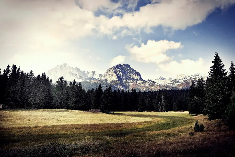
Quick Field Data
- UNESCO Inscription: 1980 · Criteria (vii), (viii), (x)
- Scale & Footprint: 390 km2 (150 sq mi) encompassing the Durmitor limestone massif and the 1,500-metre Jezerska površ plateau alongside 18 glacial lakes and the canyons of the Tara, Sušica, Draga, and Komarnica rivers
- Access & Ticketing: Day entry passes are collected at the Black Lake trailhead gate and along the Tara canyon approaches, while mountaineering trails across the massif are open without quota restrictions
- Arrival Logistics: Headquartered in the mountain town of Žabljak at 1,500 metres in northwestern Montenegro, reached by paved mountain highways from the Tara River Canyon corridor
Glaciated Karst Peaks and Europe's Deepest Gorge
Rising abruptly in northwestern Montenegro as a limestone citadel of the Dinaric Alps (Dinarides), Durmitor National Park spans 390 square kilometres (150 sq mi) of folded karst peaks and high plateaus alongside plunging river canyons embedded within the larger Tara River Basin Biosphere Reserve. Protected in Montenegro as a national park in 1952 and inscribed on the UNESCO World Heritage List in 1980, the reserve is defined by dramatic vertical relief where Pleistocene glaciers and underground karst streams sculpted a deeply fractured limestone massif. Ice and water carved every cliff here. Forty-eight jagged peaks exceed 2,000 metres (6,562 ft) above sea level, culminating in Bobotov Kuk (Bobotov Peak) at 2,523 metres (8,278 ft), which was listed as 2,525 metres in early UNESCO surveys and first climbed in 1883.
Surrounding Bobotov Kuk is a dense crown of two-thousand-metre limestone summits that give the massif its fortress-like profile: Bezimeni vrh (Nameless Peak) at 2,487 metres (or 8,159 feet), Šljeme reaching 2,455 metres (or 8,054 feet), followed by Istočni vrh Šljemena (translated as the East Peak of Sljeme) rising to 2,445 metres (or 8,022 feet), Soa or Đevojka reaching 2,440 metres (or 8,005 feet), Milošev tok at 2,426 metres (or 7,959 feet), Bandijerna at 2,409 metres (or 7,904 feet), Rbatina reaching 2,401 metres (or 7,877 feet), Lučin vrh at 2,396 metres (or 7,861 feet), the vertically fluted limestone strata of Prutaš at 2,393 metres (or 7,851 feet), Minin bogaz at 2,387 metres (or 7,831 feet), Planinica reaching 2,330 metres (or 7,644 feet), Kobilja glava at 2,321 metres (or 7,615 feet), Savin Kuk rising to 2,313 metres (or 7,589 feet), and Šupljika at 2,310 metres (or 7,579 feet), alongside the prominent peak of Stožina. To the east, these steep limestone walls drop onto a sweeping 1,500-metre (4,921 ft) high karst tableland called Jezerska površ (Plateau of Lakes), which stretches toward Mount Sinjavina in the east and hosts the park's primary gateway municipality of Žabljak.
Scattered across the Jezerska površ plateau and the glacial cirques of the high massif are 18 crystal-clear glacial lakes locally nicknamed Gorske Oči, or 'mountain eyes'. Fed by winter snowmelt and subterranean karst springs, the largest and best known of these basins is Black Lake, cupped beneath dense conifer woods at the foot of the limestone peaks just outside the town of Žabljak. Because the surrounding limestone bedrock is fractured by karst sinkholes and underground fissures, water levels across the 18 glacial basins fluctuate noticeably between the spring snowmelt and late summer.
Framing the entire mountain block on three sides is a system of colossal river gorges cut deep into the limestone bedrock. Along the northern boundary, the Tara River Canyon winds for 80 kilometres (50 mi) and plunges to a depth of 1,300 metres (4,300 ft), forming the deepest river gorge in Europe. To the west lies the Piva River Canyon, while the southern and internal flanks are gashed by the canyons of the Draga and Sušica alongside the Komarnica River Canyon. Because this rugged topography spans a vertical elevation difference exceeding 2,000 metres where warm Mediterranean climatic influences from the coast meet cold alpine air masses, the wider Durmitor massif supports more than 1,600 vascular plant species, including rare endemic flora and an ancient old-growth stand of European Black Pine clinging to the rocky canyon walls above the Tara River.
Celtic and Romanian Toponymy, Early Alpinism, and Mountain Conservation
Human presence across the high alpine meadows and canyon rims of Durmitor reflects centuries of seasonal mountain life across the Dinaric Alps, preserved in the linguistic origins of the massif's name. One historical explanation traces the name Durmitor to Romanian settlers in the Middle Ages, deriving it from a word meaning 'sleeping place' (cognate with the English word dormitory), parallel to similarly named mountains across the former Yugoslavia such as Visitor (from visător, meaning 'dreamer') and Cipitor (from ațipitor, meaning 'sleeper'). A second linguistic theory attributes the name to the ancient Celts who inhabited these valleys and the banks of the Tara River, interpreting Durmitor as 'water from the mountain' or 'ridged mountain', matching the Celtic origin of the Tara River (named after a Celtic goddess) and the Zeta River ('Loved one').
For centuries, seasonal summer shepherds grazed flocks across the 1,500-metre Jezerska površ plateau while leaving the high limestone cirques and deep river gorges largely untouched. Organized mountaineering and natural history exploration began in the late 19th century, marked by the first recorded ascent of Bobotov Kuk (2,523 m) in 1883 and documented over subsequent decades in Croatian and Yugoslav mountaineering literature such as Željko Poljak's studies in Naše planine (covering the years 1898 to 1958) alongside museum biological surveys of alpine Zygaenidae (Lepidoptera) in the Croatian Natural History Museum.
In 1952, authorities established Durmitor National Park across 390 square kilometres (150 sq mi), uniting the high massif of Durmitor with the deep river gorges of the Draga, Sušica, and Tara alongside the upper canyon plateau of Komarnica into Montenegro's largest protected area. From 1980, the UNESCO World Heritage List in 1980 and integrated into the wider Tara River Basin Biosphere Reserve, the park balances strict protection of its 18 glacial lakes and old-growth European Black Pine forests with year-round mountain recreation centred on Žabljak, Montenegro's primary ski and mountaineering resort. That balance requires ongoing safety and environmental oversight on heavily visited peaks such as Savin Kuk (2,313 m), where winter ski lift infrastructure operates directly on the high alpine slopes, including an investigation opened by authorities following a December 2025 ski lift accident on Savin Kuk.
Hiking the Glacial Cirques, Savin Kuk, and the Tara River Canyon
All field routes in Durmitor National Park radiate from the town of Žabljak on the 1,500-metre Jezerska površ plateau, where mountain roads and waymarked alpine trails provide direct access to both the 48 peaks above 2,000 metres and the northern canyon rim above the Tara River. Walking from the conifer belt around Black Lake up into the bare limestone cirques allows hikers to experience the full vertical contrast between the plateau and the 2,523-metre summit crest within a single day.
- Black Lake circuit and the ascent to Bobotov Kuk: Walk west from Žabljak through dense pine forest to the park entrance gate at Black Lake, following the shoreline footpath around its twin glacial basins where the limestone face of Savin Kuk (2,313 m) and the ridge of Šljeme (2,455 m) mirror in the clear water. Experienced mountaineers can start at dawn from the southern high road near Prutaš (2,393 m) and Stožina or hike up from Black Lake past Minin bogaz (2,387 m) and Bezimeni vrh (2,487 m) to reach the 2,523-metre summit of Bobotov Kuk, the highest peak of the Durmitor massif, where clear days reveal the entire ring of Dinaric peaks from Bandijerna (2,409 m) and Rbatina (2,401 m) across to Mount Sinjavina.
- Tara River Canyon rim viewpoints and whitewater canoeing: Drive north from Žabljak across the plateau to the rim of the 80-kilometre-long and 1,300-metre-deep Tara River Canyon, stopping at canyon-edge lookouts above the old-growth European Black Pine stands before descending into the gorge. From the riverbanks, visitors can join guided canoeing and water sports excursions down the clear rapids of the deepest gorge in Europe, passing beneath towering limestone cliffs and underground karst springs that feed the Tara River.
- Seasonal alpine pacing and Montenegro travel links: Plan high-altitude hikes and canyon excursions between late June and September, after winter snowbanks melt from the passes around Bobotov Kuk, Milošev tok (2,426 m), and Planinica (2,330 m), or visit in winter when Žabljak shifts to skiing and snowboarding. Carry warm layers and rain protection even in summer, as weather shifts rapidly across the 2,000-metre gradient between the canyons and summits. Connect your mountain itinerary with our UNESCO World Heritage Atlas and our Montenegro destination guide.
