


























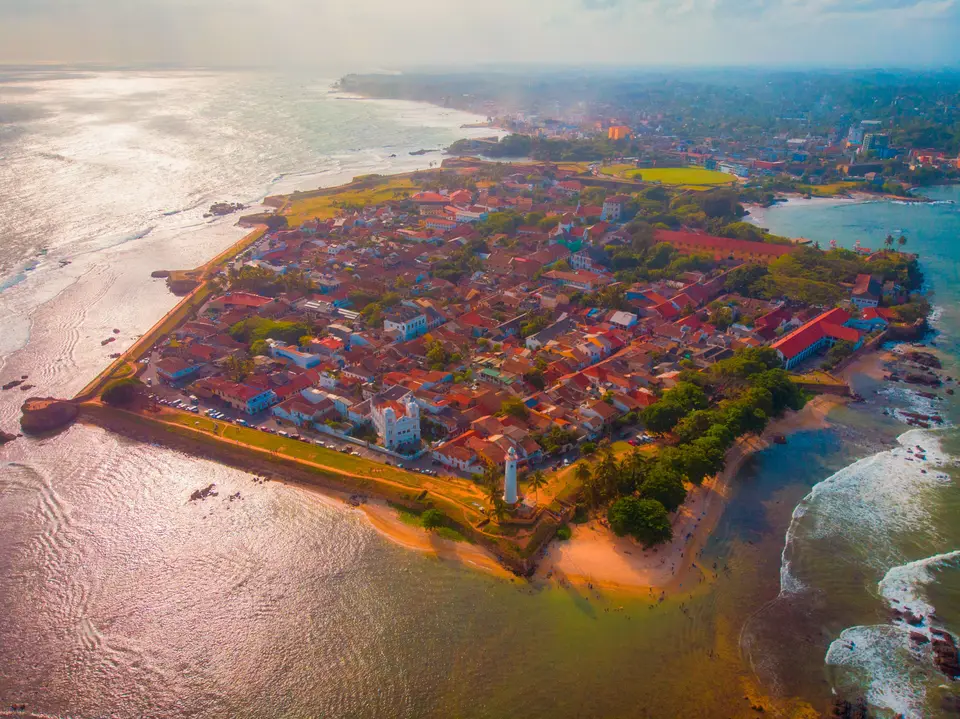
Quick Field Data
- UNESCO Inscription: 1988 under cultural criterion iv across a 52-hectare (130-acre) fortified rocky peninsula on the southwest coast of Sri Lanka.
- Scale & Footprint: Fourteen seaward and landward bastions, two historic fort gates, a Dutch colonial street grid, churches, a mosque, and the 1939 lighthouse.
- Access & Ticketing: Rampart walls and streets remain accessible without charge; verify individual museum entry schedules on the official site.
- Arrival Logistics: Linked by the Southern Expressway (opened in 2012), the coastal A2 highway (113 km), and the coastal railway line south from Colombo.
Jutting into the Indian Ocean on a rocky promontory in the Bay of Galle at the southwestern corner of Sri Lanka, the Old Town of Galle and its Fortifications represent the finest surviving fortified urban ensemble constructed by European powers across South and South-East Asia. In 1988, the UNESCO World Heritage Atlas in 1988 and covering 52 hectares (130 acres), Galle Fort (known in Sinhala as Galu Kotuwa) illustrates how European architectural models were adapted to South Asian traditions between the 16th and 19th centuries. Rather than following rigid geometric star-fort plans, Dutch military engineers adapted their coral-and-granite ramparts directly to the natural rock outcrops of the promontory. Sea winds sweep the stone walls.
Ancient Maritime Port, Portuguese Santa Cruz, and the 1640 Dutch Siege
Galle's earliest recorded history traces back to Ptolemy's world map of 125 to 150 CE, when it functioned as an active harbour conducting trade with Greece, Arab lands, and China, and Cosmas Indicopleustes noted it as a Mediterranean and Levant port of call. Several etymologies explain the name Galle: one derives it from the Portuguese word gallo ("rooster"), while another connects it to the Sinhala word gaala, signifying a cattle pen or place where livestock were herded. Before European ships arrived, the traveller Ibn Batuta called at this harbour. Portuguese involvement began in 1505 when a fleet led by Lourenço de Almeida made its first landing on the island here and established close friendship with King Dharmaparakrama Bahu (1484 to 1514). Although the Portuguese built a Franciscan chapel inside the fort in 1541 (later using the fort as a prison camp for Sinhalese natives who opposed Portuguese rule) and initially preferred Colombo, attacks in 1588 led by King Raja Singha I, of Sitawaka (1581 to 93) of Sitawaka forced them to return to Galle. There they erected a small palm-and-mud fort named Santa Cruz across the northern inland neck, later extending it with a watchtower, a fortalice, three bastions, and the seaward Zwart Bastion.
In 1640, the Dutch joined with King Rajasinhe II, and landed a force of 2,500 men under Koster to capture Galle Fort from the Portuguese. Finding the earlier earth-and-palisade defences unsafe, the Dutch decided from 1649 onwards to encircle the entire 52-hectare peninsula with stone fortifications, building 13 additional bastions in coral and granite. Many fortification walls were erected in 1663, and the continuous sea wall was completed in 1729. On 23 February 1796, just a week after Colombo fell, the British took over the fort, ruling Ceylon formally as a colony from 1815 until independence in 1948. Although Colombo eclipsed Galle as the main port in the mid-19th century, the British maintained Galle as their southern administrative headquarters, closing the moat, adding a gate between the Moon and Sun bastions in 1873, erecting a tower in 1883 for Queen Victoria's jubilee, and adding coastal defences during the Second World War.
Fourteen Bastions, Coral-and-Granite Ramparts, and Two Historic Gates
Along the eastern wall stands the oldest Portuguese-built bastion, Zwart Bastion (Black Bastion), terminating southward at Point Utrecht Bastion, where the powder house and the 18-metre (59-foot) Galle Lighthouse (erected in 1938 to 1939) stand. Next along the shore is Flag Rock Bastion, formerly a signalling station where musket shots were fired from nearby Pigeon Island to warn ships of hazardous bay rocks, followed by Triton Bastion, where a windmill drew seawater to sprinkle dusty roads and where visitors gather to watch sunsets. In total, 14 bastions ring the promontory: Sun, Moon, Star, Zwart, and Akersloot bastions (site of the oldest breadfruit tree, Artucarpus incisisus, in Sri Lanka, which according to local lore the Dutch introduced hoping its heaty nature would sicken locals until residents mixed breadfruit with coconut to create a delicacy), Aurora, Point Utrecht, Triton, Neptune, Clippenburg, Flagrock, Aeolus, Fishmark, and Commandment bastions.
- The 1669 Old Gate and VOC Emblem: Finished by Dutch engineers in 1669 near the southern end of Baladaksha Mawatha and originally defended by a drawbridge and ditch; its interior relief displays a carved rooster standing on a rock above a VOC lettered shield (Vereenigde Oostindische Compagnie) flanked by two lions and inscribed ANNO MDCLXIX (1669), while the exterior bears the British coat of arms of King George III, (showing the English lion, Scottish unicorn, House of Hanover arms, and mottoes Honi soit qui mal y pense and Dieu et mon droit) placed after 1796 alongside a 1668 stone.
- The 1873 Main Gate and 1882 to 1883 Clock Tower: Opened in 1873 between the ramparts of the Moon and Sun bastions on the northern landward wall, overlooked by the historic Clock Tower erected for Queen Victoria's jubilee.
- Groote Kerk (Dutch Reformed Church) and New Orient Hotel: Originally built in 1640 and remodelled in baroque style between 1752 and 1755 (with a Protestant church planned by Abraham Anthonisz in 1775), the Groote Kerk features floor paving made of gravestones from the old Dutch burial ground and holds a 1760 organ, a calamander-wood pulpit from Malaysia, and a belfry dated 1707 with a bell cast in 1709; nearby stands the 1694 residence of the Dutch Governor and staff, converted into the New Orient Hotel in 1865 and modernised into the Amangalla in 2005.
- Great Warehouse, Old Dutch Hospital, and Religious Landmarks: The circa-1669 Great Warehouse near the old gate (established in 1997 with assistance from the Government of the Netherlands as the National Maritime Archaeology Museum to exhibit artefacts from 21 harbour shipwreck sites), the Old Dutch Hospital (reopened in 2014 as a dining and shopping complex), the 1871 All Saints Anglican Church, the 1904 Meeran Jumma Mosque, the Buddhist temple on the former plot of the Portuguese Roman Catholic chapel, and the Clan House.
South Asian Verandas, Tidal Sewers, and Colonial Street Names
Inside the surrounding walls, the rectangular street grid reflects the Dutch tradition of parcelling out blocks within a limited area, while the narrow-fronted houses incorporate South Asian verandas shaded by high overhanging roofs on slender columns and internal courtyards. An underground brick sewerage system built by the Dutch was flooded at high tide to flush sewage out to sea; the Dutch also exploited sewer muskrats, exporting them for musk oil extraction. Colonial street names preserve colonial history: Pedlar Street (Moorse Kramerstraat), named after Moor and chetti retailers; Lighthouse Street (Zeeburgstraat or Middelpuntstraat), named after the lighthouse destroyed by fire in 1936; Hospital Street (site of the Dutch Hospital, Surgeon's house, and Medical Garden); Leyn Baan Street (Leyenbahnstraat), the historic rope-walk lane where artisans twisted coir rope; nearby Church Street; Parawa Street, named after Parawa fishermen and traders from South India; and Chando Street, named after toddy tappers alongside Dutch Burghers who kept coconut groves and small ark distilleries.
Surrounding the fort is the modern city of Galle (population 112,000 across 16.5 square kilometres, or 6.4 square miles), while Moors make up over half of the resident population within the ramparts living alongside Sinhalese, Dutch, English, Portuguese, and German residents, as well as artists, writers, photographers, designers, and poets. After the Boxing Day tsunami of 2004, the Ministry of Cultural Affairs, the Galle Heritage Foundation, the Archaeological Department of Sri Lanka, the University of Moratuwa, and the Government of the Netherlands collaborated on sensitive heritage renovations.
Rampart Walk and Coastal Transport
Walk the perimeter of the 14 bastions from the Main Gate and Moon Bastion east to Zwart Bastion and the 1669 Old Gate, continue south past the 1939 Galle Lighthouse and Flag Rock Bastion, and follow the western sea wall past Triton Bastion before exploring Pedlar Street, Leyn Baan Street, and Church Street. You can map the peninsula and bastions on the Atlas. Highway A2 (113 kilometres, or 70 miles), the 2012 expressway, and coastal rail lines link Galle directly with Colombo, Matara, and Tangalle.
Strolling along the broad rampart walk between Flag Rock Bastion, Triton Bastion, and the 1873 Main Gate at dusk shows how the fortified peninsula still functions as a living multi-ethnic and multi-religious neighbourhood rather than an empty monument. Within the 52-hectare enclosure, descendants of Moor, Sinhalese, Dutch, Portuguese, and British families share the shaded verandas and coral-stone lanes with contemporary writers, designers, and museum curators working inside restored 17th- and 18th-century townhouses.
