


























Quick Field Data
- UNESCO Inscription: 1982 · Criteria (i), (iii), (vi).
- Scale & Footprint: Extensive royal and monastic garden-city ruins beside the Parakrama Samudra irrigation reservoir in Polonnaruwa District (population 447,530 in 2024 at a density of 135.9 per km2), North Central Province
- Access & Ticketing: Managed by Sri Lankan heritage authorities with a central ticket office and museum near the Parakrama Samudra embankment; bicycles and tuk-tuks connect the north-to-south monument clusters
- Arrival Logistics: Located 3 km north of modern Polonnaruwa (New Town, postal code 51000, area code 027) in Sri Lanka's low-country dry zone, accessible by road and rail from Colombo
Chola Jananathamangalam and Parakramabahu's 12th-Century Hydraulic Garden City
Located in Sri Lanka's North Central Province across the island's low-country dry zone around coordinates 7.9158 N and 81.0006 E, 3 kilometres north of modern Polonnaruwa (known as New Town, seat of Polonnaruwa District with a 2024 district population of 447,530 and home to Polonnaruwa Royal Central College), the Ancient City of Polonnaruwa (written in Sinhala as Poḷonnaruva and in Tamil as Polaṉṉaṟuvai) preserves the palaces, Buddhist sanctuaries as well as Hindu shrines of Sri Lanka's second royal kingdom. Granite shrines and brick stupas face the water here. Placed onto the UNESCO World Heritage List in 1982 under Criteria (i), (iii) alongside (vi), the city succeeded Anuradhapura after 993 AD and reached its architectural zenith in the 12th century AD.
Known in ancient records as Pulathisipura and Vijayarajapura (or Vijayarajapuram in the historical records of Jayabahu, derived from King Vijayabahu), the name Polonnaruwa appears in Tamil inscriptions of the Chola dynasty as Pulainari, possibly contracted from Pulastya nagara or Pulatti nakaram, meaning the city of the Hindu sage Pulastya. Originally established before 1070 AD as a strategic military post by the Sinhalese kingdom, the settlement became the island's administrative centre after the South Indian Chola dynasty invaded and destroyed the older capital of Anuradhapura in 993 in the 10th century. Renaming the city Jananathamangalam (or Jananathapuram) and governing northern and central Sri Lanka as a Chola province under the Chola kings Raja Raja Chola and Rajendra Chola, the Cholas erected finely dressed stone Brahmanic monuments, led by Vanavan Mahadevisvaram (named after Raja Raja Chola's queen and known today as Siva Devale), which housed masterworks of Chola bronze casting including statues of Shiva, Ganesha as well as Parvati.
In 1070 AD, Sinhalese sovereignty over the island (then called Thambapanni) was restored by Vijayabahu the Great of Polonnaruwa. Starting from Mahanagakula to the south of the Walawe River, King Vijayabahu sent out three separate armies along three separate fronts: a western force marched up the coast to the port of Mahathittha to block South Indian reinforcements before turning toward Polonnaruwa from the northwest, an eastern force advanced across Magama to attack from the east alongside the third main army marched across the interior under the king himself, capturing Polonnaruwa after a seven-month siege.
The city's golden age arrived in the 12th century under Vijayabahu's grandson, King Parakramabahu the Great. Declaring that not a single drop of rainwater falling from the heavens should flow to the sea without first serving the land, Parakramabahu constructed an advanced network of irrigation canals and reservoirs across the dry zone (where average annual temperatures sit at 28.6 °C or 83.5 °F and annual rainfall averages 1,584 mm or 62.4 inches, concentrated across the October and November inter-monsoon period as well as the December to February northeast monsoon season). His crowning hydraulic work was the Parakrama Samudra (the Sea of Parakrama), a vast reservoir linked to the Mahaweli River that irrigated dry-season rice paddies, anchored sea-going vessels as well as cooled the walled royal garden city beside it.
The Royal Citadel, the central sacred terrace, and the Rock-Cut Gal Vihara
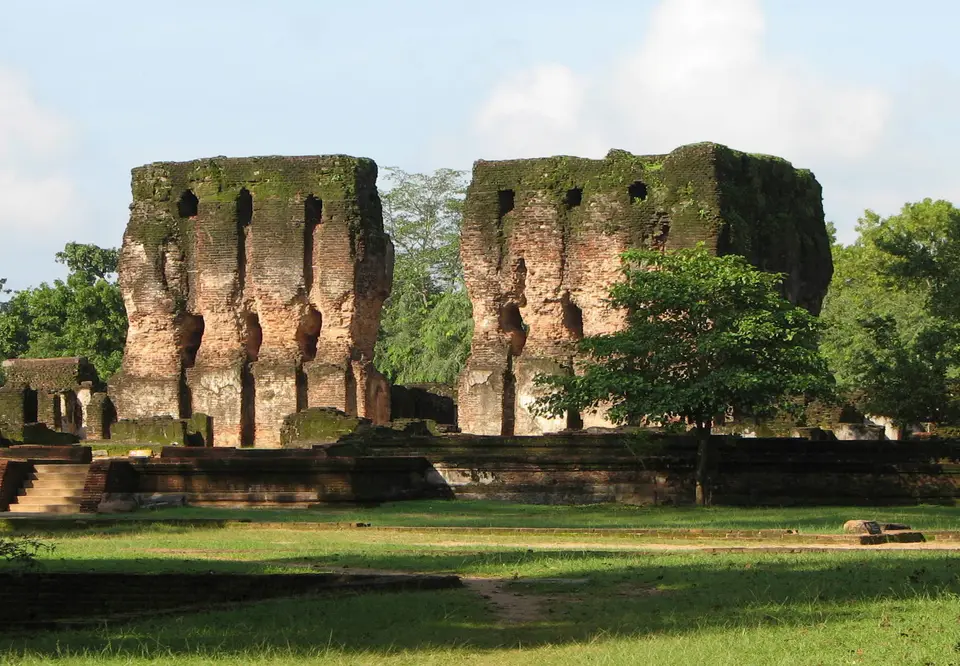
Within the inner royal citadel, Parakramabahu erected the multi-storey Royal Palace of Parakramabahu, whose thick brick walls still stand beside audience halls and lotus-shaped stone bathing pools. Immediately north of the palace enclosure rises the elevated terrace containing the city's most concentrated ensemble of 12th-century Sinhalese ritual architecture, built under Parakramabahu the Great and his strong-willed immediate successor, King Nissankamalla.
Grouped on this central terrace are the circular relic shrine of the Polonnaruwa Vatadage with its concentric rings of monolithic stone columns and carved thresholds; the rectangular shrine of the Hatadage; the pavilion of the Nissanka Latha Mandapaya, where granite pillars are sculpted like curving lotus stems inside a stone lattice railing; and the stepped brick pyramid of the Satmahal Prasada, which historians Andrew Forbes and David Henley examined in their 2012 study of ancient Chiang Mai as a historic architectural link between Sri Lanka and Lan Na.
Stretching north of the central terrace through woodland inhabited for centuries by troops of toque macaques (and chosen in 1982 as a filming location for Duran Duran's Save a Prayer music video) lie the city's colossal monastic foundations. Here rise the Menik Wehera, the towering brick dome of the Rankoth Vehera stupa, and the rock-cut sanctuary of the Gal Vihara (studied in detail by Ulrich von Schroeder in 1990 and 1992 and Jayasinghe Balasooriya in 2004), where 12th-century master sculptors carved monumental Buddhist figures directly into a long granite cliff face, creating one of the most celebrated displays of rock art and Buddhist sculpture in Sri Lanka alongside the monumental Statue of Parakramabahu.
After the reign of Nissankamalla, court rivalries and dynastic marriages with South Indian kingdoms weakened the Polonnaruwa monarchy. In 1214, the Aryacakravarti dynasty warlord Kalinga Magha invaded and devastated both Anuradhapura and Polonnaruwa by fire, prompting the Sinhalese court to shift its capital south while the irrigation tanks and forest canopy preserved the stone and brick ruins.
Cycling from the Parakrama Samudra Bund to the Gal Vihara
Because the archaeological park of Polonnaruwa extends for several kilometres from the southern Statue of Parakramabahu and the Parakrama Samudra bund north to the Gal Vihara, renting a bicycle at the entrance near New Town is the ideal way to explore the shady, level avenues connecting the monuments.
- Parakrama Samudra reservoir, the Royal Palace, and Siva Devale: Begin at the archaeological museum and ticket office on the embankment of the Parakrama Samudra tank, then cycle into the walled Royal Citadel to inspect the towering brick walls of the Royal Palace of Parakramabahu. Just outside the palace precinct, examine the dressed granite masonry of the 10th-century Chola temple of Siva Devale (Vanavan Mahadevisvaram, which originally enshrined bronze statues of Ganesha and Parvati) and trace how the city evolved from a Sinhalese military post and Chola provincial capital into the self-sufficient 12th-century garden city chronicled in the Mahawamsa.
- Polonnaruwa Vatadage, Hatadage, and Nissanka Latha Mandapaya: Ride north to the central ritual terrace to walk barefoot around the circular Polonnaruwa Vatadage, the Hatadage, the lotus-stem stone columns of the Nissanka Latha Mandapaya, and the stepped brick Satmahal Prasada. Keep your shoulders and knees covered and remove shoes and hats when approaching all Buddhist shrines in Polonnaruwa (where the modern district population includes a Sinhalese majority alongside Muslim, Sri Lankan Tamil, Indian Tamil, Burgher, and Malay communities recorded in the Thamankaduwa division).
- Rankoth Vehera, the Gal Vihara rock art, and Colombo connections: Follow the northern forest road past the Menik Wehera and the towering brick stupa of Rankoth Vehera to reach the granite face of the Gal Vihara, allowing unhurried time on foot in the early morning light to examine the rock-cut Buddhist sculptures while watching the resident toque macaques that have lived among the ruins since ancient times. Documented in the historical chronicles of the Mahawamsa and celebrated in scholarly studies of Sinhalese and Chola art, the historic royal capital of the Polonnaruwa kingdom (known in antiquity as Pulathisipura, Vijayarajapura, and Jananathamangalam) demonstrates how 12th-century hydraulic engineering around the Parakrama Samudra and the Mahaweli River sustained monumental Buddhist and Hindu architecture across Sri Lanka's low-country dry zone; together with the irrigation reservoirs and paddy fields watered by the Parakrama Samudra and the Mahaweli River, the monuments of Polonnaruwa (from the Brahmanic bronze and stone shrines of the Chola period to the Royal Palace, the Polonnaruwa Vatadage, the Hatadage, the Nissanka Latha Mandapaya, the Rankoth Vehera, the Menik Wehera, and the rock-carved Gal Vihara) form an enduring architectural record of medieval Sri Lanka; pair your route from Polonnaruwa (alongside Anuradhapura and Sigiriya) with our UNESCO World Heritage Atlas and our Colombo guide to the southwest.
