


























Quick Field Data
- UNESCO Inscription: 1982 (Cultural Criteria ii, iii, vi)
- Scale & Footprint: Over 100 square kilometres (40 square miles) of monastic precincts, colossal brick dagobas, together with hydraulic reservoirs along the Malwathu Oya river
- Access & Ticketing: Administered by the Archaeological Department of Sri Lanka; check the official site for Sacred City heritage pass coverage and individual temple entry rules
- Arrival Logistics: Located in the North Central Province of Sri Lanka, 205 kilometres (127 miles) north of Colombo by road or the Northern Railway line
Fifteen Centuries as the Royal and Spiritual Heart of Sinhalese Civilisation
Spreading across more than 100 square kilometres (40 square miles) of wooded parkland and man-made irrigation lakes along the banks of the Malwathu Oya river in Sri Lanka's North Central Province, the Sacred City of Anuradhapura functioned as the political and religious capital of the island across a span of 1,300 to 1,500 years before its abandonment following the Chola invasions of 993 and 1017 CE. For Sri Lanka, the UNESCO World Heritage Atlas in 1982 under cultural criteria ii, iii, and vi, the ancient metropolis stands 205 kilometres (127 miles) north of Colombo and functions today as the administrative capital of both North Central Province and Anuradhapura District. Unlike purely archaeological ruins, Anuradhapura remains a vital pilgrimage sanctuary where white-clad Buddhist devotees circumambulate brick stupas that were already centuries old in classical antiquity, and where a documented fig tree grown from a 3rd-century BCE cutting still receives daily ceremonial offerings. Pilgrims gather beneath its branches daily.
The etymology of the city is recorded in the 5th-century CE historical chronicle Mahāvaṃsa, which relates how a minister named Anuradha at the court of Prince Vijaya (who reigned from 543 to 505 BCE) founded an early settlement named Anuradhagama near the Kadamba River, known today as the Malwathu Oya. While the Mahāvaṃsa places the early founding of the settlement in 437 BCE, archaeological excavations in the citadel area push protohistoric Iron Age habitation back to the 10th century BCE: between 900 and 600 BCE, iron technology, Plain Grey Ware pottery (linked to Painted Grey Ware from North India), horses, domestic cattle, plus irrigated paddy cultivation appeared on site, expanding across at least 50 hectares between 700 and 500 BCE. Following the early Sinhala kingdoms of Tambapanni and Upatissa Nuwara, King Pandukabhaya (who reigned from 474 to 367 BCE) formally laid out Anuradhapura (joining the founder's name with the word pura, signifying a city across Sinhala, Sanskrit, together with Pali) as the royal capital in 377 BCE, constructing city gates, trader quarters, as well as reservoirs across a fortified area of 1 square kilometre. By the 2nd century CE, the Greco-Roman geographer Claudius Ptolemy recorded the thriving inland metropolis in his Geographia under the name Anourogrammoi among the cities of Taprobane.
Jaya Sri Maha Bodhi and the Orthodox Maha Viharaya Precinct
The decisive spiritual transformation of Anuradhapura occurred during the reign of King Devanampiya Tissa between 250 and 210 BCE. Following the introduction of Buddhism to the island by the Indian prince-monk Mahinda in the 3rd century BCE, Mahinda's sister Sanghamitta, founder of an order of Buddhist nuns, arrived bringing a sacred branch taken at Bodh Gaya inside Bihar, India, from the original Bodhi Tree beneath which the historical Buddha reached enlightenment. Devanampiya Tissa planted this sapling, known as the Jaya Sri Maha Bodhi, south of the walled citadel, establishing the Anuradhapura Maha Viharaya and initiating an urban layout in which the royal citadel was ringed by vast monastic complexes (viharas) and hydraulic tanks.
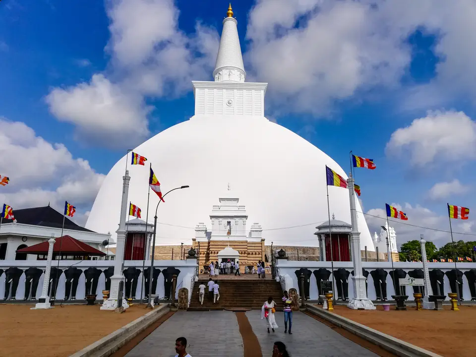
The spiritual axis of the southern monastic zone still begins at the Jaya Sri Maha Bodhi, recognised as the oldest living, historically documented, human-planted tree in the world. Supported above a stepped stone terrace surrounded by protective railings, the sacred fig tree survived centuries of dynastic conflict and jungle encroachment because local watchers maintained guard fires around its enclosure. Immediately north of the Bodhi Tree rises the Lovamahapaya, built in the 2nd century BCE as the chapter house and communal refectory of the Maha Viharaya monastery. Its forest of 40 parallel rows of monolithic granite columns once supported a multi-storey timber superstructure roofed with bronze tiles where resident monks gathered for canonical recitals. A short walk north brings visitors to the Ruwanwelisaya (Ruwanweli Maha Seya), the whitewashed hemispherical stupa surrounded by a stone courtyard and a perimeter wall sculpted in high relief with hundreds of brick and plaster elephants standing shoulder to shoulder. Slightly further north stands the Thuparamaya, the earliest historical stupa built in Sri Lanka under Devanampiya Tissa in the 3rd century BCE, encircled by concentric rings of slender monolithic stone pillars with carved capitals that once supported a conical timber roof over the shrine.
Colossal Brick Dagobas, Hydraulic Reservoirs, and Intellectual Heritage
Across the 1st millennium CE, Anuradhapura flourished as the intellectual cradle of Theravada Buddhism, hosting the 5th-century Buddhist philosopher Buddhaghosa and witnessing the redaction of the Theravada Buddhist canon during the reign of King Dhatusena (455 to 473 CE), who also constructed 18 new temple complexes, erected a statue to Mahinda, and engineered the great Kala Wewa reservoir. In the late Anuradhapura period, royal and noble patrons also commissioned bronze and stone sculptures depicting the Bodhisattva Avalokitesvara, revered for mercy together with compassion. Walking or cycling across the wider sacred zone reveals four distinct monastic and hydraulic landscapes:
- Jetavanaramaya Monastery: Founded in the late 3rd century CE, the colossal brick stupa of Jetavanaramaya (Jetavanarama) originally rose to roughly 120 metres in height and remains one of the largest brick structures ever erected in the ancient world, laid over deep brick foundations reaching down to bedrock.
- Abhayagiri Dagaba and Vihara Complex: Established in the 1st century BCE to the north of the inner citadel, Abhayagiri Vihāra grew into a vast international monastic university housing thousands of monks who studied both Theravada and Mahayana traditions, preserving twin stone bathing ponds, limestone Buddha sculptures, plus carved moonstone threshold slabs.
- Mirisaveti Stupa, Lankarama, Isurumuniya, and Vessagiriya: Marking the western and southern approaches to the ritual circuit, the Mirisaveti Stupa, the pillar-ringed Lankarama, the rock-side temple of Isurumuniya, alongside the boulder shelters of Vessagiriya illustrate how royal votive monuments and cave retreats anchored every sector around the citadel.
- Tissa Wewa and the Royal Uyana Park: Sustaining this dense urban population across a tropical savanna climate required an interconnected network of artificial lakes, including the Bassawakkulama reservoir, Tissa Wewa reservoir, together with Kala Wewa, whose waters also fed the rock-cut bathing pools of the Ranmasu Uyana royal park below the Tissa Wewa bund.
Chola Invasions, the 1949 Preservation Plan, and Visitor Logistics
The political era of Anuradhapura ended when the Chola king Rajaraja I, invading from South India during 993 CE, followed by his son Rajendra I, who completed the conquest in 1014 and 1017 CE, sacked the city and shifted the capital southeast to Polonnaruwa. Although later Sinhalese kings, including Vijayabahu IV between 1267 and 1270 CE, returned to restore major monuments, dense jungle gradually enveloped the palaces while a small village maintained pilgrimage watch at the Bodhi Tree, as recorded by English captive Robert Knox in his 1681 account of Anurodgburro and British physician John Davy in 1821. Modern revival began in the 1870s under British colonial administration and accelerated when rail engineers opened Anuradhapura Railway Station along the Northern Railway line in 1904. In 1949, the Government of Ceylon commissioned town planner Oliver Weerasinghe to draft the Anuradhapura Preservation Plan, establishing the Anuradhapura Preservation Board to relocate government offices, law courts, as well as residents eastward into a planned New Town. Between 1958 and 1962, Government Agent and Preservation Board Chairman Nissanka Wijeyeratne completed this transition, unveiling a memorial to former administrator H. R. Freeman and establishing the modern Sacred City zone.
- Entry and Route: Anuradhapura is connected directly to Colombo, Jaffna, alongside Kankesanthurai by the Northern Railway line, with major express trains such as the Yal Devi and Uttara Devi stopping at Anuradhapura station, plus highway bus routes 04, 15, 57, and 87 linking Colombo, Vavuniya, Dambulla, Matale, Puttalam, Trincomalee, Kurunegala, and Kandy.
- Tickets and Viewpoints: Because the monuments span a vast parkland, hiring a bicycle or three-wheeler for the full day is the most practical way to link the southern Jaya Sri Maha Bodhi and Isurumuniya circuit with the northern Abhayagiri and Jetavanaramaya precincts; check the official site for current heritage pass rules.
- Timing and Onward Connections: Shoulders and knees must be covered at all sacred sites, and shoes, socks, together with hats must be removed before stepping onto temple terraces. Carry water and sun protection for cycling between the reservoirs and stupas.
