


























Quick Field Data
- UNESCO Inscription: 1986 (Cultural, Criterion v; placed on the danger register between 2016 and 2025)
- Scale & Footprint: Circular fortified oasis settlement built around the Ain al-Faras spring (ghusuf), flanked by the Great Erg sand sea and the stone plateau of Al Hamada el-Hamra, supporting a population of roughly 10,000 inhabitants across seven traditional clan districts
- Access & Ticketing: Located in northwestern Libya near the borders with Illizi Province in Algeria and Tataouine Governorate in Tunisia; check the official site for current travel advisories, security clearances, and entry regulations for the old town and Ghadames Museum
- Arrival Logistics: Situated approximately 462 km (287 mi) southwest of Tripoli within the Nalut District of the Tripolitania region, served by desert highways and Ghadames Airport
From Tidamensi and Roman Cydamus to Trans-Saharan Caravan Hub
Located at 30.1333 degrees north and 9.5000 degrees east in the pre-Saharan belt of northwestern Libya, the Old Town of Ghadamès (known in Ghadamsi as Ɛadēməs and in Italian as Gadames) stands in a palm-fringed oasis between the shifting dunes of the Great Erg sand sea and the rocky expanse of the Al Hamada el-Hamra stone plateau. Situated roughly 462 km (287 mi) southwest of Tripoli inside the Nalut District of Tripolitania, the settlement borders both the Illizi Province of Algeria and the Tataouine Governorate of Tunisia. Its hot desert climate (classified under the Köppen system as BWh) produces intense summer heat in July averaging 41°C (105.8°F) alongside cool winters with pronounced diurnal temperature variations, while annual precipitation averages only 73.1 mm (1.30 in). In this hyper-arid environment, permanent human habitation depended entirely on the perennial freshwater source of the Ain al-Faras spring, known locally as ghusuf. Archaeological evidence indicates that the oasis has been settled since the 4th millennium BC, ranking it among the oldest pre-Saharan urban settlements in North Africa.
The etymology of Ghadamès is closely linked with its ancient tribal and imperial history. Historical traditions connect the name to the ancient Berber Tidamensi people from Fezzan, whose tribal name was adapted by invading Roman forces into the Latin form Cydamus before evolving into the modern name Ghadamès. The earliest written records of the oasis date to the Roman period in the 1st century BC, when Roman proconsul Lucius Cornelius Balbus marched into Cydamus under Emperor Augustus. Under Emperor Septimius Severus, who possibly visited the oasis around AD 202, a permanent Roman military garrison was established at the site, leaving behind stone archaeological remains including Roman period defences and the largest ancient mausolea in the region around the outer edge of the old town before Roman troops withdrew several decades afterward during the Third Century Crisis. Later, in the 6th century, a Christian bishop resided in the oasis after Byzantine missionaries converted the population to Christianity, and the town became a stronghold of the Donatist movement until its conquest by Muslim Arabs.
Following the arrival of Muslim Arab rulers in the late 7th century, the population quickly converted to Islam and transformed Ghadamès into an important and peaceful commercial base for trans-Saharan caravan trade until the 19th century. Arab sources celebrated the prosperous oasis city as Jawhart Al-Sahra, or the Pearl of the Desert. In the 12th century, the Arab geographer Abu Hamid al-Gharnati classified Ghadamis with the trading lands of Sudan, a hypothesis that the historian Saad considers plausible because Ghadamis consistently maintained commercial settlers representing the town in Timbuktu. Alongside caravan trade in desert commodities, Ghadamis functioned as a major node in the trans-Saharan slave trade while preserving its own distinctive social customs, mud-brick building traditions, and artisanal handicrafts.
Vertical Domestic Architecture, Covered Alleys, and Clan Districts
The urban morphology of the Old Town of Ghadamès was engineered specifically to mitigate the 41-degree summer heat and dry desert winds while meeting the socio-cultural needs of its predominantly Berber population of around 10,000 inhabitants. Built in a compact circular shape determined by climatic conditions and water management, the built fabric is interwoven with the surrounding date-palm groves and enclosed by a continuous city wall formed by the reinforced outer mud-brick walls of the peripheral houses. Within this protective circuit, the historic settlement was divided among seven clans, each of which inhabited its own distinct district equipped with a public gathering place where community festivals and assemblies could be held, alongside neighbourhood mosques and water channels fed by the Ain al-Faras spring.
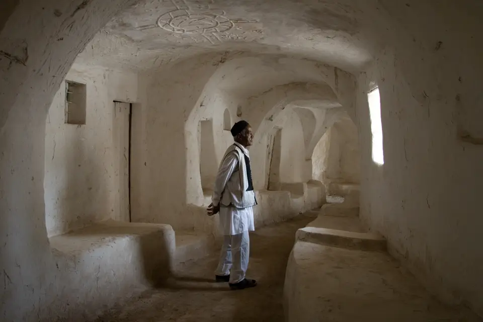
Unlike courtyard houses found in other parts of the Islamic world, the domestic architecture of Ghadamès is characterised by a strict vertical division of functions across three levels. The ground floor of each house acts as a cool, windowless storage area used to store agricultural supplies and commercial goods. Above the ground level, the first floor is reserved for the family living quarters, overhanging the streets below to create covered alleys that form what is almost an underground network of shaded passageways across the entire town. These projecting upper rooms shelter pedestrians from direct solar radiation, keeping the ground-level lanes cool and dark even at midday. At the top of the mud-brick buildings, open-air terraces linked across neighbouring rooftops are reserved exclusively for women, allowing them to move freely across the town and conduct daily social life in complete privacy above the covered streets below.
The twentieth century brought rapid political and demographic shifts to the oasis, documented by early European visitors such as Edmond Bernet in his 1912 study published by Fontemoing in Paris and later analysed by scholars including Nora Lafi (2006) and Intisar Azzouz in the May 1980 Aga Khan Award for Architecture seminar proceedings edited by Linda Safran in Amman, Jordan. In October 1911, soon after the outbreak of the Italo-Turkish War, Italian soldiers marching from Tripoli occupied Ghadamès. Italian control over the oasis was disrupted repeatedly until June 1915, when a widespread uprising across Libya forced the Italian garrison to withdraw to Tripoli. Italian authority returned in December 1918, although revolt across Fezzan kept Ghadamès under emergency rule until 1923. In 1943, Free French troops occupied Ghadamès and the southern sector of the former Italian colony, establishing the Military Territory of Fezzan-Ghadames with Ghadamès as its capital until Libyan independence in 1951. In the 1970s, the government built new modern houses outside the old town, and filmmaker Moustapha Akkad selected Ghadamès to film interior scenes of Medina for the Islamic epic drama film The Message. Although the old town was gradually depopulated throughout the 1990s, many inhabitants return to the historic mud houses during the summer because the traditional architecture provides superior protection against the heat.
Civil Conflict, Conservation Status, and Field Navigation
Following its inscription on the UNESCO World Heritage List in 1986, the depopulated mud-brick buildings of the Old Town of Ghadamès faced risk of collapse due to lack of maintenance. Until 2011, independent Tuareg troops controlled the city, but during the Libyan Civil War, forces of the National Transitional Council (NTC) besieged the oasis and entered Ghadamès on 30 August 2011; following the town's capture by the Libyan National Army, the local Tuareg population was displaced from the settlement. Because of damage and threats caused by the Libyan Civil War, the Old Town of Ghadamès was placed on the danger register between 2016 and 2025 alongside four other sites in Libya before its removal in 2025. You can map its frontier position near Algeria and Tunisia using our interactive world map. Desert heat shapes every street.
- Navigating the covered alleyways and rooftop terraces: Exploring the labyrinth of subterranean-like covered passageways requires walking beneath the overhanging first-floor family rooms, where light wells pierce the mud-brick ceilings at regular intervals to ventilate the ground-level lanes and illuminate the whitewashed walls.
- Tracing the Ain al-Faras water channels: Follow the stone and mud-lined distribution channels leading outward from the Ain al-Faras spring (ghusuf), which regulated the flow of water through the seven clan districts and irrigated the surrounding palm groves that buffer the circular city wall against encroaching sand dunes.
- Inspecting the outer defences and oasis landmarks: Outside the reinforced outer house walls of the medieval core, examine the stone archaeological remains of Roman period defences and the largest ancient mausolea in the region, as well as the Ghadames Mosque and the ethnographic collections housed inside the Ghadames Museum.
