


























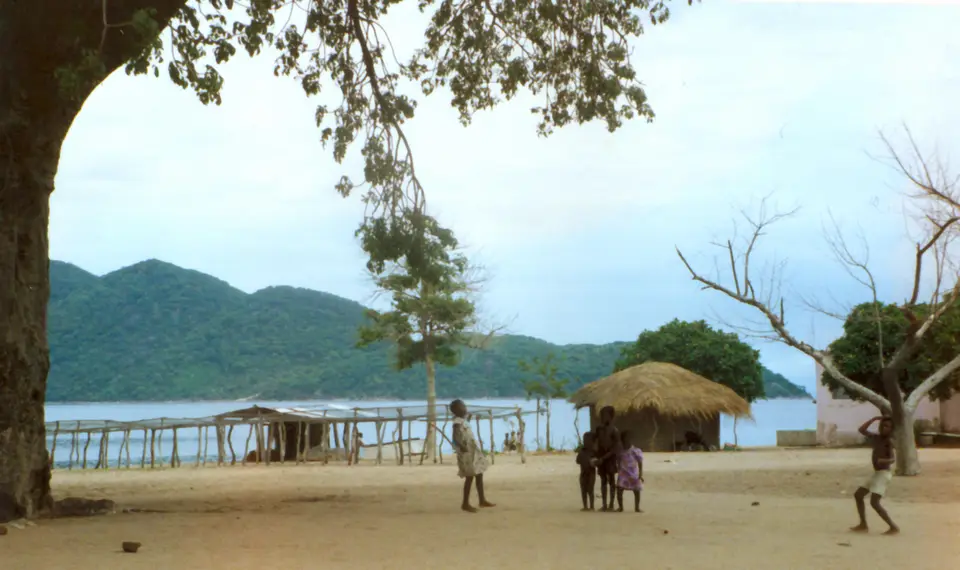
Quick Field Data
- UNESCO Inscription: 1984 · Criteria (vii), (ix), (x).
- Scale & Footprint: 94 to 95 square kilometres (37 square miles) of terrestrial headland and lacustrine waters at the southern end of Lake Malawi (including an aquatic protection zone extending 100 metres from shore across 0.02 percent of the lake's surface), encompassing the Nankumbu Peninsula and 13 islands
- Access & Ticketing: Established on 24 November 1980 as Malawi's first national park dedicated to protecting freshwater fish and aquatic habitats; accessed via the lakeside enclave village of Chembe at Cape Maclear with boat alongside kayak and snorkelling excursions to the offshore islands
- Arrival Logistics: Situated in the Central and Southern Regions of Malawi at the southern extremity of the Western Rift Valley lake, southeast of the national capital, Lilongwe
Rift Valley Bathymetry alongside the Nankumbu Peninsula and 13 Islands
Positioned at the southern extremity of the vast expanse of Lake Malawi within the Central and Southern Regions of Malawi in Southeast Africa, Lake Malawi National Park protects a dramatic convergence of forested granitic mountains and crystal-clear freshwater bays. Created as a national park on 24 November 1980 and inscribed on the World Heritage List in 1984 during the 8th session under natural criteria (vii), (ix), and (x), the 94- to 95-square-kilometre (37-square-mile) reserve is the only national park in Malawi created specifically to safeguard freshwater fish populations and their aquatic habitats. Clear waters reveal living evolution.
Geologically, Lake Malawi occupies a deep tectonic trough within the Great African Rift Valley (the Western Rift Valley). While the surface of the lake rests at 500 metres (1,640 feet) above sea level, its floor plunges in places to a depth of 700 metres (2,300 feet), ranking Lake Malawi among the deepest lakes in the world. Formed several million years ago and isolated hydrologically from other major African river basins, the lake has experienced pronounced water-level fluctuations across the millennia, repeatedly fragmenting and reconnecting its rocky and sandy shoreline habitats beneath the steep Rift Valley escarpment.
Within the 95-square-kilometre national park boundary lies a diverse mosaic of terrestrial and lacustrine landforms: most of the mountainous Nankumbu Peninsula (which projects northward into the southern basin of the lake and terminates at the headland of Cape Maclear), the Mwenya Hills, the Nkhudzi Hills, the sandy arc of Nkhudzi Spit, and 13 offshore rocky and wooded islands: Otter and Domwe alongside Thumbi West, Thumbi East, Mumbo, Zimbabwe, Mpanda, Boadzulu, Nankoma, Maleri, Nakantenga, and Chinyankhwazi Rock and Chinyamwezi Rock. Steep granitic hills rise directly out of the shoreline waters, climbing on the Nankumbu Peninsula to 1,143 metres (3,750 feet) at Nkhunguni Peak in the west and 963 metres (3,160 feet) at Dzimwe Peak in the east.
Crucially, the park's aquatic boundary extends 100 metres (330 feet) outward from the lakeshore of the mainland peninsula and around each of the 13 islands. Although this 100-metre-wide underwater buffer zone represents just 0.02 percent of Lake Malawi's total surface area, it encompasses the precise shallow-water photic zone of submerged granite boulders alongside rocky reefs, sandy bays, and wooded hill slopes and reed-fringed swamps and lagoons where the lake's highest concentration of endemic aquatic life breeds and feeds.
Adaptive Radiation of 350 Mbuna Cichlids and Terrestrial Rift Fauna
In the history of evolutionary biology, Lake Malawi National Park holds a scientific stature directly comparable to the Galápagos Islands studied by Charles Darwin for their finches or the volcanic islands of Hawaii for their honeycreepers. Considered an independent freshwater biogeographical province, Lake Malawi harbours an estimated 700 to roughly 1,000 species of fish, the largest number of fish species documented in any single lake in the world, and approximately half of all those species occur within the waters of the national park.
What makes this underwater biodiversity an unmatched natural laboratory for studying biological evolution and speciation at work is the explosive adaptive radiation of the family of cichlid fishes, especially the small, brilliantly coloured rocky-shore tilapiine cichlids known locally in Malawi as mbuna (rockfish). Over 350 species of mbuna have been recorded within Lake Malawi National Park, and all but five of those 350 species are strictly endemic to Lake Malawi. Because the rocky headlands and the 13 islands are separated from one another by stretches of deep water or open sand that rock-dwelling mbuna refuse to cross, each isolated boulder reef and island shoreline has functioned as an underwater island. Across millennia of fluctuating lake levels, cichlid populations trapped on individual rocky outcrops evolved specialized jaw structures, tooth shapes, and feeding behaviours and bright breeding colours to exploit microscopic niches, scraping algae from sunlit granite boulders, picking plankton from the water column, or defending miniature rock territories, so that many endemic species have ranges restricted to a single bay, a single rocky islet, or just a few hundred metres of shoreline, with numerous species still awaiting formal scientific description.
Above the waterline, the dense deciduous woodlands clothing Nkhunguni Peak and Dzimwe Peak and the 13 islands shelter a rich community of terrestrial mammals alongside reptiles and birds. Troops of chacma baboons and vervet monkeys forage along the forest edge beside stealthy leopards, while the rocky slopes and lakeside thickets support agile klipspringers and common duikers alongside bushbucks and greater kudus. In the sheltered lagoons and river mouths swim hippopotamuses and Nile crocodiles. Overhead, the park's birdlife is headlined by pairs of vocal African fish eagles perching in shoreline trees and large breeding colonies of white-breasted cormorants on islands such as Boadzulu, joined by kingfishers and hornbills alongside wading birds, nightjars, and kestrels and swallow-tailed bee-eaters.
Human history is equally woven into the Cape Maclear headland. While the steep forested interior of the Nankumbu Peninsula is largely uninhabited, several historic lakeshore fishing villages, above all Chembe village beside Cape Maclear, lie as enclaves within the geographic perimeter of the park without forming part of the reserve land. In 1859, the Scottish missionary and explorer Dr. David Livingstone became the first European to reach the lake (then called Lake Nyassa), and in 1875 the Scottish Presbyterian Church established a Presbyterian mission station on Cape Maclear. Near the shore stands a massive baobab tree reputed to be over 800 years old, under whose shade Livingstone reportedly preached sermons and conferred with fellow missionaries, close to the stone graves of five early Scottish missionaries who succumbed to tropical fever at the lakeshore.
Snorkelling the 100-Metre Aquatic Zone and Kayaking from Cape Maclear
Because the transparent waters along the granite boulders of Cape Maclear and the offshore islands act as a natural freshwater aquarium, visitors can observe hundreds of endemic mbuna cichlids simply by slipping on a mask and snorkel a few metres from the beach.
Base your visit around Cape Maclear and Chembe village to combine underwater cichlid observation with island kayaking and peninsula trail walks.
- Snorkel the 100-metre rocky littoral zone off Otter and Thumbi West islands: Hire a local boat or kayak from Cape Maclear across the clear water to Otter Island or Thumbi West Island. Float over the submerged granite boulders within the 100-metre aquatic reserve zone to watch clouds of bright blue alongside yellow and striped mbuna rockfish grazing on rock algae and guarding territorial crevices in water visibility that contrasts sharply with the rugged granitic cliffs overhead.
- Kayak to Mumbo and Domwe islands and scan for African fish eagles: Paddle a sea kayak between the 13 protected islands, including wooded Domwe and Mumbo and Boadzulu and Maleri alongside Nankoma and Nakantenga, watching the shoreline boulders for monitor lizards and white-breasted cormorants alongside kingfishers and swallow-tailed bee-eaters while listening for the ringing calls of African fish eagles perched in the lakeshore canopy.
- Hike the Nankumbu Peninsula trails and visit the 1875 mission graves: Follow the forest footpaths climbing toward Nkhunguni Peak (1,143 metres) or Dzimwe Peak (963 metres) to spot klipspringers and chacma baboons alongside vervet monkeys and hornbills, and pause at the 800-year-old Livingstone baobab tree and the five 1875 Scottish Presbyterian missionary graves at Cape Maclear. To plan your overland journey to the southern lakeshore, start from our closest city guide in Lilongwe and explore other Rift Valley parks in our UNESCO World Heritage Atlas.
