


























Quick Field Data
- UNESCO Inscription: 1986 (Cultural Criteria i, iii, iv)
- Scale & Footprint: 4,187 hectares containing more than 1,600 surviving monuments in the Tungabhadra river basin of central Karnataka
- Access & Ticketing: Administered by the Archaeological Survey of India (ASI) and the Government of Karnataka; check the official site for monument passes and museum entry
- Arrival Logistics: Located in the Vijayanagara (formerly Bellary) district of central Karnataka near Hospet (13 kilometres away) and Jindal Vijaynagar Airport (32 kilometres away)
The Imperial Capital of Vijayanagara in the Boulder-Strewn Tungabhadra Basin
Set amidst a dramatic granite terrain of craggy boulder-strewn hill ranges, open agricultural plains, and the winding gorge of the Tungabhadra River in eastern and central Karnataka, the Group of Monuments at Hampi (locally called Hampe, PIN code 583239, at an elevation of 467 metres above sea level) preserves the vast physical footprint of Vijayanagara, the last capital of the great Hindu Kingdom of Vijayanagara. Throughout India, the UNESCO World Heritage Atlas in 1986 under cultural criteria i, iii, and iv across an expanse of 4,187 hectares and mapped on the Atlas, the site encompasses more than 1,600 surviving architectural, military, hydraulic, and religious remains within the Vijayanagara district (carved out of Bellary / Ballari district), situated just 13 kilometres from the nearest railway city of Hospet (Hosapete). Today, more than 700,000 tourists travel to Hampi each year to walk through its Dravidian temple precincts, colonnaded bazaar streets, fortified gateways, defence check posts, water structures, and royal enclosures. Giant granite boulders frame every temple tower.
Long before the rise of the medieval empire, the river gorge and surrounding granite hills held deep sacred associations in Indian antiquity. Mentioned in Ashokan epigraphy and celebrated in the Hindu Puranas and Sanskrit literature as Pampaa Devi Tirtha Kshetra, the river valley of Hampi is traditionally identified with Kishkindha, the ancient kingdom described in the Sanskrit epic Ramayana. In the 14th century CE, the rulers of the Vijayanagara Empire established their imperial capital here as the political, administrative, military, and economic bulwark of the Deccan and South India against the neighbouring Islamic sultanates. Across more than two centuries of rule between the 14th and 16th centuries, the fabulous wealth of Vijayanagara's princes, supported by irrigated agriculture, iron ore and manganese mining, and international trade, won the admiration of travellers who visited the metropolis at its height and recorded its monumental Dravidian temples, royal palaces, and sprawling urban markets.
To defend and supply this huge urban population in a semi-arid river basin that receives an average of about 660 millimetres of annual rainfall (a figure that continues to vary under the impacts of climate change), Vijayanagara's planners skilfully and harmoniously integrated town and defence architecture directly into the natural granite boulder ridges while engineering a sophisticated hydraulic system of river channels, stone aqueducts, stepped water structures, and reservoirs that still irrigate local farmlands growing paddy and maize, jowar and bajra millets, groundnut, sunflower, cotton, and sugarcane near the large modern dam. Around each of the large Dravidian temple complexes grew self-contained suburban townships known as puras, complete with subsidiary shrines, residential quarters, water tanks, and long stone-pillared bazaars that delineated the economic prosperity, social complexity, and political status of a highly developed society. This golden age ended abruptly in 1565 when the combined armies of the Deccan Muslim confederacy conquered the empire and pillaged the capital over a period of six months, leaving the city abandoned until 19th- and 20th-century archaeologists and historians (including D. Devakunjari for the Archaeological Survey of India, Anila Verghese, John M. Fritz, George Michell, Clare Arni, S. Srinivasachar, and T. S. Satyan for the Directorate of Archaeology and Museums of the Government of Karnataka) documented its 1,600 surviving monuments.
Dravidian Temple Complexes, the Vitthala Enclosure, and the Royal Centre
Under the patronage of the Vijayanagara emperors, South Indian Dravidian architecture flourished and reached its ultimate monumental form, characterised by massive dimensions, vast cloistered courtyard enclosures, lofty entrance towers (gopurams), and sprawling pillared halls (mandapas) encased by sculpted granite pillars:
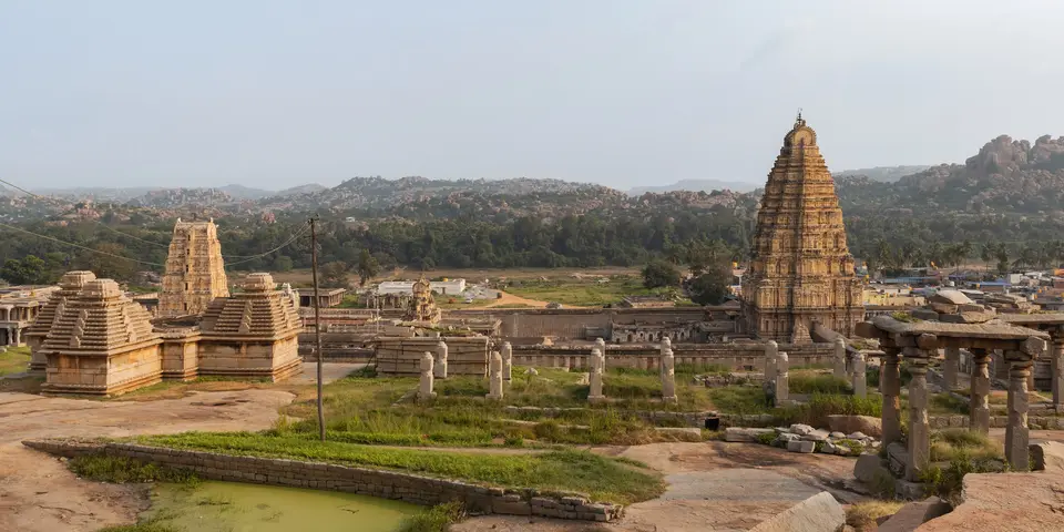
- The Virupaksha Temple, Hemakuta group, Ganesa, and Narasimha: Standing on the southern bank of the Tungabhadra River at the western head of the broad Hampi Bazaar (viewed panoramically from nearby Matanga Hill and across the river toward Anegundi), the Virupaksha Temple remains an active centre of Hindu worship, flanked immediately to the south by the early granite shrines and stepped pavilions of the Hemakuta group of temples alongside monumental monolithic sculptures of Ganesa and Narasimha carved directly from the local granite boulders.
- The Vitthala temple complex: Widely recognised as the most ornate structure on the site and the architectural culmination of Vijayanagara temple building, the Vitthala temple complex rises as a fully developed sanctuary inside a large cloistered stone enclosure pierced by three lofty entrance gopurams. Within the paved courtyard, alongside the main sanctum and stone chariot shrine, stand associated ceremonial buildings including the Kalyana Mandapa and the Utsava Mandapa, whose decorated granite pillars are carved in deep relief to support the heavy stone eaves and roof slabs.
- The Krishna, Achyutaraya, and Pattabhirama temple complexes: Distributed across the valleys and former suburban puras, the sprawling Krishna temple complex, the Achyutaraya temple complex set below Matanga Hill with its own colonnaded bazaar street and water tank, and the expansive Pattabhirama temple complex demonstrate the massive scale of 16th-century imperial temple endowments, where each temple precinct functioned as the religious, civic, and commercial heart of its surrounding suburban township.
- The Lotus Mahal complex, royal stables, and fortified enclosures: South of the sacred riverside zone lies the fortified royal and administrative quarter, where surviving remains include the multi-arched pavilion of the Lotus Mahal complex, domed royal stables, pillared audience halls, memorial structures, monumental gateways, defence check posts, and stepped water structures that combine courtly ceremony with military and hydraulic engineering across the open plains and rocky ridges. Together, these royal and sacred monuments illustrate how Vijayanagara's builders adapted grey-pink granite masonry to serve both the austere military demands of a fortified Deccan capital and the grandiose ceremonial life of the court.
Festivals, Overland Travel History, and Practical Transport Logistics
From the 1960s onwards, when local road and visitor infrastructure was still in poor condition, Hampi also became a magnet for overland motorbikers and offbeat travellers (nicknamed "Hampi Hippies") who gathered on the boulder hills and amidst the ruins of the "lost city" for parties and spiritual retreats, while the Government of Karnataka continues to celebrate the historic imperial tradition every year through the annual Hampi Utsava ("Vijaya Festival"), organised as the state Nada Habba festival across the illuminated monument precincts:
- Entry and route: Hampi (home to a village population of 2,777 in the 2011 Census where Kannada is the official language, surrounded by irrigated farming, heritage tourism, and the regional extraction of iron ore, manganese, and other minerals) lies 13 kilometres from the closest railway station in the city of Hospet (Hosapete) and 32 kilometres (20 miles) from Jindal Vijaynagar Airport in Toranagallu, which operates regular flight connections to Bengaluru. By road and rail, Hampi is situated 266 kilometres (165 miles) from Belgaum, 348 kilometres (216 miles) from Bangalore (Bengaluru), and 385 kilometres (239 miles) from Hyderabad, with overnight buses and trains linking Hospet directly with Goa and Bengaluru across Karnataka.
- Tickets and viewpoints: Walking through the open granite boulder hills, riverside features, subsidiary shrines, Hampi Bazaar, and Hemakuta Hill is open without charge, whereas entering the cloistered Vitthala temple complex (with its three entrance gopurams, Kalyana Mandapa, and Utsava Mandapa), the Lotus Mahal complex, and the Archaeological Survey of India Museum Hampi requires an official ASI admission ticket; check the official site of the Archaeological Survey of India and Bellary / Vijayanagara district authorities for combined day passes and local transport rules.
- Timing and onward connections: Climb Matanga Hill or the Hemakuta ridge at sunrise or sunset when low sunlight illuminates the Tungabhadra river gorge, Hampi Bazaar, and lofty temple gopurams, and allow at least two to three full days to explore both the sacred riverside complexes (Virupaksha, Vitthala, Krishna, Achyutaraya, and Pattabhirama) and the southern royal and fortified enclosures before crossing the Tungabhadra toward historic Anegundi.
