Quick Field Data
- UNESCO Inscription: Ref. 1189 · Cultural Site · Inscribed 2006 · Criteria (ii), (iii), (iv), (v)
- Scale & Footprint: 48-hectare walled historic town (Jugol) at 1,885 metres elevation, cushioned by a buffer zone extending 800 metres south and 1,700 metres east into surrounding farmland
- Access & Ticketing: Protected as an Ethiopian National Heritage site since 1974 and supervised by the Jugol Heritage Conservation Office (JHCO) and ARCCH; walled lanes are open on foot while house museums, Jamia Mosque precincts, and Rimbaud House apply local admission and dress rules
- Arrival Logistics: Roughly 500 to 525 kilometres east of Addis Ababa and 47 kilometres from Aba Tenna Dejazmach Yilma International Airport (DIR) in Dire Dawa
Ramparts of Nur ibn Mujahid and the Five Historic Gates
Perched atop a highland plateau at 1,885 metres above sea level, Harar Jugol is cut off by deep surrounding gorges between eastern Ethiopian deserts and savannahs. Inside just 48 hectares, the fortified old town packs centuries of African and Islamic urban craft. Called Harar-Gey or simply Gey (meaning the city) in the indigenous Harari language, it is known in Arabic as Madinat al-Awliya (City of Saints). Sitting roughly 500 to 525 kilometres east of Addis Ababa, this compact walled hill town serves as the regional capital of the Harari People National Regional State (HPNRS) inside predominantly Christian Ethiopia.
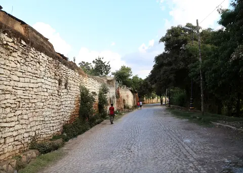
Its defensive limestone-and-mud wall, built in stages between the 13th and 16th centuries and consolidated defensively in the mid-16th century under Emir Nur ibn Mujahid following Oromo advances at the Battle of Hazalo, strictly bounds the historic core. Five original gates pierced this perimeter wall, aligned straight onto regional caravan paths connecting the interior highlands of Shewa to Red Sea and Gulf of Aden ports such as Zeila. Historically, those five gates divided Harar Jugol cleanly into five distinct residential quarters (though modern administration no longer relies on the gate division, and a newer sixth opening, Harar Gate, now feeds wide commercial streets on the western side).
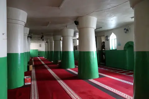
Inside the gates, the town adheres closely to a classic 16th-century Islamic urban plan. Commercial markets and sacred buildings anchor the central ridge around Jamia Mosque, radiating outward into a dense, pedestrian-scale maze of narrow winding alleyways bordered by windowless perimeter compound walls. Within this tiny 48-hectare footprint cluster an extraordinary concentration of religious monuments: 82 mosques (three preserving origins dating back to the 10th century) and 102 shrines honouring local saints and scholars, earning Harar widespread standing as the fourth holiest city of Islam.
From the Adal Sultanate to the Dawud Emirate
Archaeological hints and local chronicles point to deep pre-Islamic and early Islamic roots across the plateau. Archaeologist Timothy Insoll suggests the name Harar likely derives from the ancient Harla people who inhabited a 6th-century kingdom across the region prior to Oromo migration. By contrast, 19th-century explorer Richard Francis Burton linked the name to a southern plain or local tree, while regional outsiders long termed residents Hadharee, echoing Arabic for urban dwellers. By the 9th century the area lay within the Makhzumi dynasty's Sultanate of Shewa. Islam gained firm coastal footing by the 10th and 11th centuries via Zeila trade routes noted later in the 12th century by Jewish traveller Benjamin of Tudela. Local manuscript tradition preserved in the 13th-century chronicle Fath Madinat Harar relates that saint Abadir Umar ar-Rida arrived from the Arabian Peninsula with 405 saints circa 1216 (612 AH). He united Argobba, Gaturi, and Harla groups and later fought Christian forces until 1301 after spending decades in Mecca, while his brother Fakr ad-Din founded Mogadishu's sultanate. Harar's earliest concrete mention in external chronicles appears in 1332 under Ethiopian Emperor Amda Seyon, recording that Harar sent three governors to support Salih at the Battle of Das.
Harar surged to regional supremacy after the Walashma dynasty returned from Yemen in 1415 to establish the Adal Sultanate nearby at Dakkar. In 1520, Sultan Abu Bakr ibn Muhammad transferred the Adal capital directly into Harar. In 1525, Imam Ahmad ibn Ibrahim al-Ghazi (known as Gragn or Gurey, the Left-handed) killed the Sultan and installed Umar Din as puppet ruler. Ahmad turned Harar into the launchpad for campaigns across highland Ethiopia until his 1543 defeat. Ahmad's widow Bati del Wambara launched fresh expeditions in 1548 and married Nur ibn Mujahid in 1551. In 1559, Ethiopian forces under Ras Hamalmal breached Harar and slew the last Walashma sultan, Barakat ibn Umar Din, though Harar briefly survived when Nur defeated and killed Emperor Gelawdewos at Fatagar. Yet Oromo raids following the Battle of Hazalo prompted Nur to raise Harar's protective wall, trapping refugees inside as two crippling famines and plague swept the town and claimed Nur himself in 1568.
Chaotic coups followed involving Uthman the Abyssinian (whose clash with Aussa governor Jibril sparked clerical revolt under Talha ibn Abbas) and Nasir ibn Uthman. Muhammad ibn Nasir was betrayed, captured, and executed after the Battle of Webi River under Emperor Sarsa Dengel, while local commander Mansur ibn Muhammad briefly seized power using Somali allies before mutiny killed him. Muhammad Gasa shifted the imamate capital north to Aussa by 1584. Harar remained governed by local wazirs including Muhammad Gasa II, Saddadin, Sabraddin ibn Adam (five years starting in 1620), Sadiq (fourteen years starting in 1632), and Abram (who ruled only eleven months). Stability returned in the mid-17th century when Ali ibn Da'ud seized power after Emir Ahmed's ten-day reign and founded the independent Emirate of Harar, establishing a dynasty that ruled for two centuries. Despite fierce early Oromo clashes (including an attack reaching Asmadin gate on 1 September 1662 that killed Ali's son Sabr ad-Din), successor Emir Abdullah forged durable alliances through five strategic marriages with Oromo women. Those ties opened steady agricultural and caravan trade linking Shewa west to Zeila east. Emirs struck local coinage definitively by 1789, though early contested coins bear dates read as 615 AH or 1218 CE. Eighteenth-century rulers such as Emir Ahmad the First ibn Abi Bakr (who raised Jamia Mosque's minaret in 1761) and Emir Abd al-Shakur ibn Yusuf expanded registries, Islamic scholarship, and Mecca Sharif migrations. Later unrest brought the 1821 succession conflict between brothers Abd ar-Rahman and Abd al-Karim after Emir Ahmad II, the 19th-century Egyptian Khedivate period, and integration into Ethiopia in 1887.
Harari Courtyard Houses, Indian Verandas, and Afocha Ties
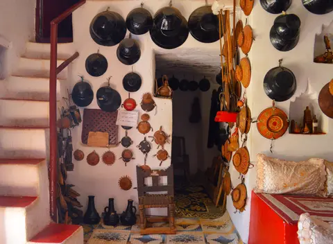
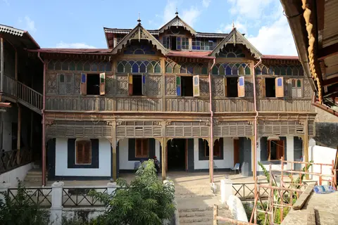
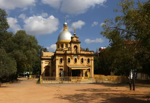
What distinguishes Harar visually from other fortified Islamic towns is its domestic interior architecture and late 19th-century cross-cultural rebuilding. Oral tradition also notes that the Silt'e, Wolane, and Halaba peoples lived inside early Harar before migrating toward the Gurage region, leaving Harari speakers closely bound to urban life inside the walls. A traditional Harari house presents plain, protective earthen-and-stone walls to narrow lanes, yet opens internally into a courtyard compound. Interiors feature elevated stepped seating platforms (nadaba), richly painted walls, sculpted plaster niches holding ceremonial baskets and imported porcelain bowls, and dark-timber ceilings evoking coastal Arab traditions. Following expanded Red Sea trade in the late 19th century, Indian merchants settling in Harar built multi-storey townhouses distinguished by carved wooden verandas and upper-floor galleries. Exemplified by the house museum tied to French poet-turned-trader Arthur Rimbaud, these inspired hybrid Indian-Harari townhouses across central lanes. Meanwhile, 19th- and 20th-century shifts replaced the central principal mosque with an Orthodox Church and widened the main artery inside the western gate.
Intangible social rules keep this historic physical fabric alive. Communities preserve the Harari language and centuries-old artisan crafts including handloom weaving, polychrome coiled basketry, and traditional manuscript bookbinding. Neighbourhood mutual-aid associations called afocha regulate weddings, funerals, dispute resolution, and street upkeep directly through spatial proximity, binding daily domestic life to historic courtyard spaces.
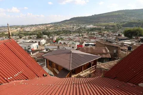
Preserving living mud, stone, and timber architecture inside a growing regional city demands continuous supervision. Registered as an Ethiopian National Heritage site since 1974, Jugol is safeguarded under Regional Proclamation No. 21/1992 and the January 2000 HPNRS heritage conservation draft proclamation. Federal Proclamation No. 209/2000 makes unpermitted demolition or interference with historic stone homes, war relics, or shrines a criminal offence. Monitoring unites the national Centre for Research and Conservation of Cultural Heritage (ARCCH, established 1976) and the Jugol Heritage Conservation Office (JHCO, established 2003). JHCO acts as liaison between the Harari Counsel under the HPNRS General Meeting, local Kebele administrative offices, the Urban Development Support Service, and German technical advisors. Using GIS inventories and an Urban Master Plan, officials assign four strict conservation tiers: principal monuments, important historic buildings, contextual urban fabric, and out-of-context structures. Managers confront three modern threats, starting with urban sprawl encroaching against the narrow western buffer next to new Harar. They also contend with roof clutter such as television antennas and residents replacing breathable lime-washed stone and carved wood doors with cement plaster and sheet metal.
Protection Zones and Monument Access Inside the Walled Town
Measuring scarcely 48 hectares inside its unbroken 16th-century circuit, Harar Jugol divides naturally on foot between its commercial spine, gated walls, merchant mansions, and eastern farming slopes.
| Complex Zone | Key Highlights | Access & Ticket Rule |
|---|---|---|
| Central Core & Jamia Mosque Spine | 16th-century market axis, Jamia Mosque with 1761 minaret, Orthodox Church on former mosque ground, and widened west entry street | Public markets and lanes open on foot; entering active mosques or churches requires modest attire and non-prayer timing |
| Five Historic Gates & Alley Quarters | 13th-to-16th-century stone walls, five original caravan gates (including Buda and Erer), and 102 neighbourhood shrines | Pedestrian alleyways open freely; ask household permission before stepping across private courtyard thresholds |
| Merchant Mansions & Harari House Museums | Arthur Rimbaud House Indian-veranda mansion, combined Harari-Indian townhouses, and traditional painted-niche interiors | Individual house museums sell local entrance tickets on site; check current museum hours locally |
| Eastern & Southeastern Agricultural Buffer | 800-metre southern and 1,700-metre eastern green slope belts preserving rural caravan setting beyond walls | Open perimeter viewpoints contrasting preserved wall edges against urban expansion crowding the western gate |
Three Architectural Markers Across the Walled Alleys
Walking between Buda Gate, Rimbaud House, and Jamia Mosque exposes three physical details that explain Harar's layered architectural history.
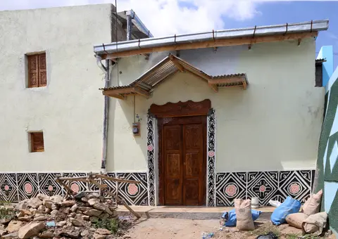
- Layered Compound Walls Along Bent Lanes: Notice how streets bend tightly past high lime-washed rubble walls pierced mainly by small carved wooden doors and rain spouts rather than street-facing windows, protecting family courtyard privacy while guiding foot traffic toward central markets.
- Indian Wooden Verandas Over Harari Stone Cores: Looking up at Rimbaud House near Feres Magala and neighbouring late 19th-century townhouses reveals timber lattice screens and cantilevered wooden verandas perched straight over older masonry ground storeys, marking the late 19th-century arrival of Indian trade guilds.
- Original Stone Masonry vs Modern Cement Plasters: Along wall sections near Buda Gate and interior residential alleys, spot traditional porous stone laid in mud-and-lime mortar next to newer cement-plastered repairs and sheet-metal doors that conservation officers work actively to reverse.
Walk Jugol's narrow paved alleys early in the morning before market crowds peak or in cool late afternoon light across the 1,885-metre plateau. Inside its 48-hectare defensive wall, five ancient gates, 82 mosques, 102 shrines, and painted courtyard rooms keep eastern Ethiopia's Islamic urban heritage alive. Allowing unhurried time inside Rimbaud House, local Harari home museums, and peripheral craft workshops makes the contrast between quiet domestic interiors, busy central bazaars, and green eastern farming slopes far easier to appreciate on foot. Combine eastern Ethiopia's walled Islamic capital with highland itineraries in our Addis Ababa travel guide or explore additional African historic towns in the UNESCO World Heritage Atlas.