Quick Field Data
- UNESCO Inscription: 1996 (Ref. 775), cultural monument in central Hiroshima; recognised under Criterion (vi) as a stark symbol of nuclear devastation and global peace.
- Scale & Footprint: 0.40 hectares encompassing the preserved Genbaku Dome ruin, surrounded by a 42.7-hectare buffer zone covering Peace Memorial Park.
- Access & Ticketing: Observed freely from outside the perimeter fence along river paths inside the park. No admission tickets are required to walk around the monument; check official Hiroshima City sites for nearby civic museum entry and ceremony notices.
- Arrival Logistics: Commercial flights land at Hiroshima Airport (HIJ), 43 kilometres east, with Matsuyama Airport (MYJ) 67 kilometres across the sea. Iwakuni Kintaikyo Airport (IWK), 34 kilometres away, operates limited passenger routes, while rail links reach east to Osaka (281 kilometres).
From Exhibition Hall to Genbaku Dome
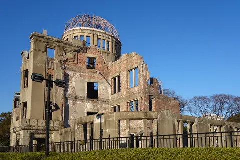
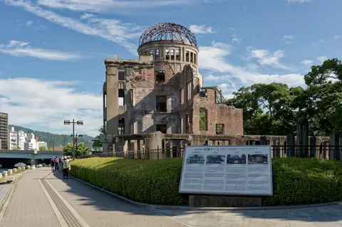
Walking across central Hiroshima toward Aioi Bridge, travellers meet a stark jagged brick shell crowned by bare iron ribs beside the Motoyasu River. Asking what is the Hiroshima Peace Memorial reveals a sharp contrast between prewar civic ambition and wartime devastation. Completed in April 1915 to designs by Czech architect Jan Letzel, the building formally opened in August that year as the Hiroshima Prefectural Commercial Exhibition (HMI). Its European masonry, vertical piers, central courtyard geometry, and copper-clad dome quickly distinguished it inside Hiroshima's busy business district next to Aioi Bridge. Before wartime destruction, the hall functioned as a civic landmark hosting regional art displays, commercial trade exhibits, and public educational events across central Hiroshima.
Renamed the Hiroshima Prefectural Products Exhibition Hall in 1921 and the Hiroshima Prefectural Industrial Promotion Hall (Hiroshima-ken Sangyo Shoreikan) in 1933, the building operated primarily as a civic venue for art displays, industrial exhibitions, and educational fairs. Behind ornamental stone and brick facades, Letzel engineered an earthquake-resistant frame tying thick brick exterior walls around steel reinforcement. That structural resilience carried the hall safely through regional earthquakes both prior to the Second World War and in the decades after. Nobody attending quiet prewar exhibitions could foresee how vertical reinforcement would leave those exact columns upright after a nuclear detonation directly overhead.
On the morning of 6 August 1945, during the closing days of the Second World War, the first atomic bomb ever used in warfare exploded above Hiroshima. Allied military planners selected the T-shaped Aioi Bridge as their visual aimpoint because central Hiroshima held a dense urban population, lacked severe conventional bomb damage, and contained no known prisoner-of-war camp. Carrying explosive energy equal to 15,000 tons of TNT, the bomb missed Aioi Bridge by 240 metres and detonated straight above nearby Shima Hospital. Three days before Nagasaki and nine days before Japan's surrender, the flash and shockwave obliterated surrounding wooden districts and claimed over 140,000 lives.
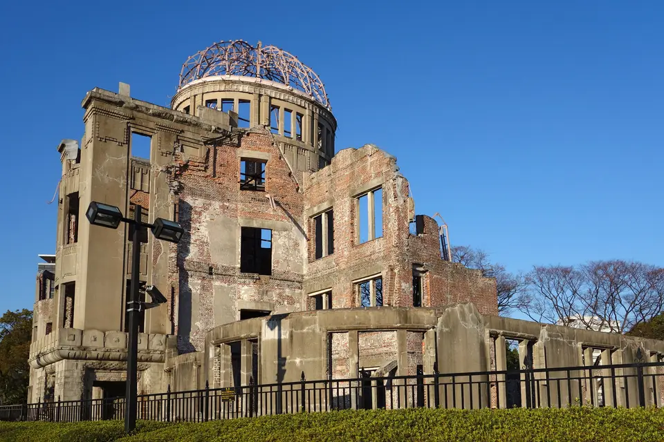
Because the explosion occurred 600 metres vertically and merely 150 metres horizontally from the Industrial Promotion Hall, blast pressure drove straight downward from almost directly overhead. Everyone working inside died instantly, yet Letzel's vertical concrete and brick piers resisted downward compression without snapping sideways. Gutted by fire and stripped of its copper dome cladding down to curved metal ribs, the shell remained the sole structure standing close to the hypocentre. Residents soon named the scorched skeleton Genbaku Dome, linking the Japanese term for atomic bomb with its exposed dome armature.
Postwar Debate and Preservation Inside the Peace Park
Early postwar reconstruction sparked painful disagreement across Hiroshima over whether the charred walls should stand or vanish beneath new development. Many surviving residents urged tearing the battered shell down because its silhouette brought constant reminders of wartime grief. Others insisted with equal urgency that demolishing the sole standing witness beside the hypocentre would risk weakening public memory of the world's first nuclear bombing. Because its sturdy stone and steel core remained mostly intact compared with flattened timber neighbourhoods around it, early demolition plans stalled while surrounding districts rebuilt. Today the skeletal shell survives beside other preserved Second World War architectural ruins such as Coventry Cathedral, St. Nicholas Church in Hamburg, and Berlin's Kaiser Wilhelm Memorial Church.
Between 1950 and 1964, city planners laid out the 42.7-hectare Peace Memorial Park around the riverbank ruins as a civic ground for prayer for atomic bomb victims and lasting world peace. In 1966, Hiroshima City Council ended two decades of debate by adopting a formal resolution committing to permanent preservation of the Genbaku Dome. Shinzo Hamai, Hiroshima's first popularly elected mayor, campaigned domestically and internationally for funds, even soliciting donations directly from pedestrians on Tokyo streets. Initial stabilisation finished in 1967, anchoring weakened brickwork strictly in its immediate post-blast profile.
Conservation engineers carried out two further subtle preservation campaigns between October 1989 and March 1990 and again during 2002 and 2003. Crews inserted discreet interior steel tie-rods and synthetic resin anchors to halt rain weathering and seismic cracking while keeping every scorched surface, shattered window bay, and bent dome girder unchanged from August 1945. Standing in its exact original location beside Aioi Bridge, the monument preserves full authenticity across form, design, materials, substance, setting, and spiritual purpose. Designated a Historic Site under Japan's 1950 Law for the Protection of Cultural Properties, the 0.40-hectare ruin receives financial and technical backing from Japan's national government and undergoes thorough structural condition surveys by Hiroshima City once every three years. Surrounding parkland gained extra protection in 2007 as a Place for Scenic Beauty under the same cultural law.
When UNESCO inscribed Genbaku Dome on the World Heritage List in December 1996, international delegates weighed complex historical perspectives. Chinese representatives expressed concern that a war memorial might obscure wartime suffering across victim countries, while United States delegates dissociated themselves from the decision over war-context framing. Recognised under Criterion (vi), the monument communicates both the immense destructive power humanity created and the shared commitment to eliminate nuclear weapons. Dignitaries visiting the monument have included US President Barack Obama on 27 May 2016, reciprocated by Japanese Prime Minister Shinzo Abe at Honolulu's USS Arizona Memorial, and G7 summit leaders on 19 May 2023.
Urban Sightlines, Civic Life, and Visitor Access
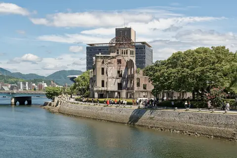
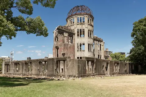
Keeping a compact 0.40-hectare ruin dignified inside a living modern metropolis requires rigorous municipal design rules across the entire 42.7-hectare buffer zone. Hiroshima City enforces a city beautification plan suited to an International Peace Culture City, requiring formal consultation over building heights, street alignments, exterior wall colours, construction materials, and illuminated advertising boards visible around the park. Standing across the Motoyasu River or beneath landscaped trees, clean sightlines frame the skeletal iron dome clearly against open sky without commercial clutter. Daily park maintenance operates directly out of a city management office inside the park in coordination with Hiroshima Prefecture's cultural heritage division and national authorities.
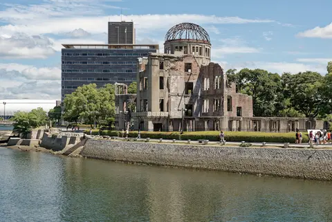
Today Genbaku Dome anchors quiet reflection as well as active civic expression. Every year on 6 August, Hiroshima's municipal government leads the annual Peace Ceremony beside the riverbank to remember bombing victims and affirm global peace. Year-round, citizens also gather outside the perimeter fences for peaceful anti-war vigils, anti-nuclear rallies, and anti-nuclear-power demonstrations. Archival and contemporary photos taken from Aioi Bridge or riverfront lawns reveal how calm grass paths and open water preserve stark visual contrast around the 1915 brickwork. Comparing the quiet, open-sided masonry frame against nearby Aioi Bridge and Shima Hospital helps every visitor grasp the exact vertical geometry of the August 1945 blast without requiring dramatic displays inside the fenced zone itself. Because visitors observe both exterior elevations and surviving internal steel braces cleanly from the surrounding paths, the ruined hall conveys its message through bare architectural endurance rather than added commentary. Preserved intentionally in its post-blast condition as a reminder of nuclear warfare's human cost, the 0.40-hectare site links the everyday streets of central Hiroshima directly to global efforts supporting disarmament and peace.
Standing along the waterfront promenade facing the T-shaped Aioi Bridge, visitors see exactly how prewar architecture intersected with wartime geography. Unlike surrounding wooden merchant houses and workshops flattened instantly across central Hiroshima, Letzel's reinforced concrete-and-brick frame survived intense thermal flash and vertical shockwaves right near Shima Hospital. Today, clear descriptive markers along the river path trace each conservation campaign from Mayor Shinzo Hamai's 1967 stabilisation through the 1989-to-1990 and 2002-to-2003 structural projects, ensuring the silent masonry shell endures intact for future generations without altering its 1945 outline.
Travellers checking practical logistics often ask about Hiroshima Peace Memorial tickets and gated access before arriving. No tickets or timed passes are required to view the UNESCO monument itself, because visitors remain outside the outer conservation fences along wide public promenades circling every elevation. Both external and internal integrity remain easily legible from outside the perimeter rails, and those wishing to explore wider historical documentation inside the Peace Park can combine the open river walk with municipal memorial halls nearby.
Access Zones Around the Peace Park
Because the preserved monument stands inside a flat riverside park in central Hiroshima, visitors can explore all key viewpoints and historical markers comfortably on foot.
| Complex Zone | Key Highlights | Access & Ticket Rule |
|---|---|---|
| Genbaku Dome Perimeter (Core Site). | 1915 masonry facade, exposed iron dome ribs, interior bracing frame, and Motoyasu River reflections. | Interior closed for safety and preservation. Observed freely from outside outer fences year-round with no tickets needed. |
| Aioi Bridge & River Promenade. | T-shaped Aioi Bridge visual aimpoint, riverbank lawns, and clear viewpoints of every elevation. | Open public streets and riverside paths accessible at all hours without fences or admission fees. |
| Former Shima Hospital Hypocentre. | Street marker pinpointing the blast centre 150 metres horizontally and 600 metres vertically from the dome. | Located on public urban streets just east of the river promenade; open year-round. |
| Peace Memorial Park Buffer Zone. | 42.7-hectare scenic park hosting 6 August memorial ceremonies, landscaped trees, and civic memorial grounds. | Park grounds open freely year-round. Confirm local booking rules on city sites for indoor museum halls. |
Three Structural Details Visible From the Genbaku Dome Perimeter
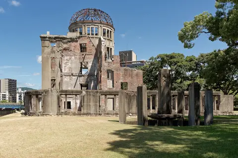
- Exposed Iron Dome Armature: Look straight up at the roof crown above the central bay. Extreme heat vaporised the outer copper sheeting on 6 August 1945, leaving Jan Letzel's curved steel ribs exposed against the sky as the monument's defining silhouette.
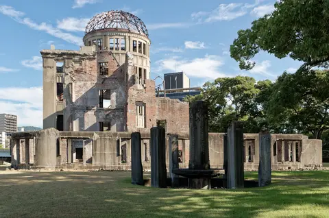
- Surviving Vertical Masonry Piers: Trace the surviving brick and stone columns facing Aioi Bridge. Because the bomb exploded 600 metres nearly directly overhead, downward shockwaves compressed the vertical piers into their foundations instead of snapping them sideways.
- Discreet Postwar Steel Bracing: Look past the shattered window openings into the open courtyard shell. Minimal interior steel frames and synthetic resin anchors inserted in 1967, 1989 to 1990, and 2002 to 2003 keep the 1915 ruin standing without erasing its 1945 state.
Timing Visits and How to Get to Hiroshima Peace Memorial Park
Early mornings and late afternoons offer calm footpaths and oblique riverside sunlight across the brick facades before tour groups gather along Aioi Bridge. Planning what to do during a visit starts with walking a slow circuit around the dome perimeter fences, locating the former Shima Hospital hypocentre marker 150 metres east, and strolling south through the 42.7-hectare Peace Park. When weighing the best time to visit, spring and autumn bring mild walking weather, whereas 6 August draws solemn memorial crowds during peak summer heat.
Travellers mapping how to get to Hiroshima Peace Memorial Park arrive via Hiroshima Airport (HIJ), 43 kilometres east, or Matsuyama Airport (MYJ) 67 kilometres across the Seto Inland Sea, while Iwakuni Kintaikyo Airport (IWK) at 34 kilometres handles limited passenger flights. Direct western Honshu rail lines also connect Hiroshima smoothly with Osaka (281 kilometres east), linking this quiet riverside landmark with other monuments inside our UNESCO World Heritage Atlas.