Quick Field Data
- UNESCO Inscription: Cultural site inscribed in 1996 (Ref. 776) under criteria (i), (ii), and (iv).
- Scale & Footprint: 431.2 hectares on Itsukushima (Miyajima) Island in Hatsukaichi, Hiroshima Prefecture (encompassing 17 shrine buildings, three associated structures, and roughly 422 hectares of forest around 535-metre Mount Misen), buffered by a 2,634.3-hectare island and sea zone.
- Access & Ticketing: Reached by ferry from Miyajimaguchi Station on the mainland; shrine walkways charge a modest entry fee, with separate ropeway or trail access up Mount Misen, and visitors should check the official site for current tide tables and restoration schedules.
- Arrival Logistics: Hiroshima Airport (HIJ, 57 kilometres northeast) and Matsuyama Airport (MYJ, 62 kilometres south) act as primary commercial hubs; closer Iwakuni Kintaikyo Airport (IWK, 18 kilometres) operates limited passenger routes, and Osaka sits 295 kilometres east.
Sacred Island Geography and Taira no Kiyomori's Sea Sanctuary
Itsukushima, widely called Miyajima, rises abruptly from the Seto Inland Sea in Hatsukaichi, Hiroshima Prefecture, pairing coastal pine inlets with steep granite slopes crowning Mount Misen at 535 metres (1,755 feet). Ranked as the chief Shinto shrine (ichinomiya) of Aki Province, it stands among the Three Great Shrines of Aki Province alongside Take Shrine and Hayatani Shrine. The sanctuary honours the sanjoshin, three sea-and-storm goddesses regarded as daughters of Susano-o no Mikoto: Ichikishimahime no mikoto, Tagorihime no mikoto, and Tagitsuhime no mikoto (also worshipped at Munakata Taisha). Because Itsukushima translates as island dedicated to the gods, Shinto reverence treated the entire landmass itself as a living deity.
First erected as early as the 6th century, with local tradition attributing an initial gate in 569 to Saeki Kuramoto during the reign of Empress Suiko (592 to 628 CE), the shrine assumed its enduring monumental form in 1168 under Taira no Kiyomori. As governor of Aki Province and later Daijo-daijin (Chancellor), Kiyomori expanded Taira maritime dominance across the Inland Sea and Song-dynasty China (960 to 1279) trade routes. Tradition recounts that an old monk promised Kiyomori dominion over Japan if he rebuilt the Miyajima sanctuary; viewing the three island goddesses as manifestations of Kannon, he transformed the remote cove into the Taira family shrine and a showpiece for visiting nobles and royal guests. During the 12th century, aristocratic clans frequently funded major shrines to display political stature and personal wealth, and Kiyomori deliberately chose Itsukushima to step outside standard Shinto pilgrimage conventions while anchoring Taira navigation bases along Seto Inland Sea sea-lanes. He and his sons also donated the celebrated Heike Nokyo, thirty-two hand-copied sutra scrolls of the Lotus, Amida, and Heart sutras embellished with silver, gold, and mother-of-pearl. Together, the shrine's sacred bay and forested island peaks later prompted international parallels with Mont Saint-Michel in France as twin coastal sanctuaries shaped by shifting tides.
Later centuries tested the island's ritual sanctity. In 1555, Choshu warlord Mori Motonari waged battle against Sue Takafusa directly on Itsukushima, violating strict Shinto taboos prohibiting bloodshed on sacred ground. Seeking purification and renewed patronage over Aki Province, Motonari reconstructed the honden main hall in 1571. Together with the adjoining Sessha Marodo-jinja complex and the Kyakuden (Guest-God's Shrine), the sole structure surviving from the Kamakura period, the 17 buildings and three associated structures in the inscribed precinct uphold late 12th- and early 13th-century timber forms even after two major historical rebuilds. Today, walking up behind the waterfront halls leads either by forested footpath or ropeway toward Mount Misen's 535-metre summit, tying the coastal timber pavilions directly back to the primordial mountain worship that first sanctified the island.
Shinden-zukuri Pier Layout, the Otorii Gate, and Tidal Purity
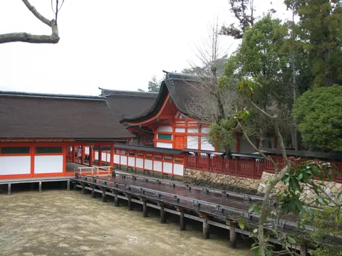
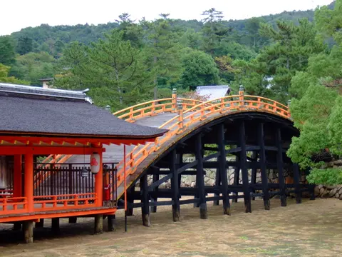
To prevent ordinary pilgrims from treading directly on sacred island earth, medieval architects turned Itsukushima Shrine into a palace resting over Matsushima bay. They borrowed the symmetrical winged pavilions and open galleries of Heian aristocratic shinden-zukuri residences, reflecting twelfth-to-sixteenth-century traditions that let trees, water, and landscapes enter residential design. Builders set the eight-by-four-bay main hall (honden), unusually long main oratory (haiden), and equally elongated offertory hall (heiden) upon wooden pilings driven into the intertidal sandbar. At high tide, seawater washes beneath slatted boardwalks and wraps the vermilion pillars. With the sea in front, architecture at centre, and Mount Misen forest behind, the composed trinity stands among Japan's classic standards of scenic beauty.
Strict purity codes reinforced this amphibious plan. Historically, commoners could neither settle permanently nor step onto the island indiscriminately, instead steering wooden boats beneath the offshore entrance gate before worshipping from the water. Since 1878, local custom and regulations have prohibited births, burials, and deaths near the sanctuary, meaning expectant mothers and the terminally ill cross to the mainland as birth or passing approaches. On shore behind the bay, the shrine buildings present crisp architectural contrast: steep kirizuma gable roofs shingled in layered cypress bark, bright vermilion beams, and exterior walls finished through 15 coats of smooth white stucco.
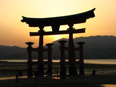
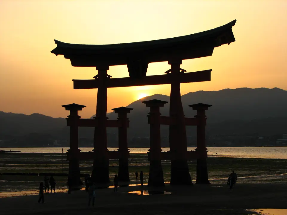
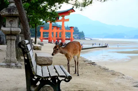
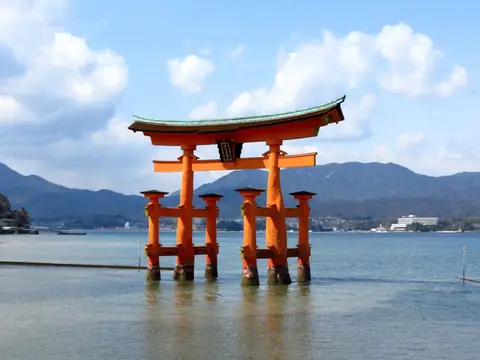
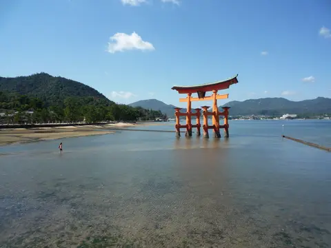
Standing offshore in front of the main hall, the 15-metre-tall (50-foot) vermilion Otorii forms the coastal threshold of the sanctuary. Although a sea gate has anchored this spot since 1168, the present Otorii dates to 1875 and is framed from naturally decay-resistant camphor wood. Adding front and rear stabilising legs beside each primary column identifies the design as Ryobu Shinto (dual Shinto), reflecting medieval links with Shingon esoteric Buddhism. When the tide rises, the four-legged camphor structure stands isolated in the Seto Inland Sea (illuminated at night from shore lights); when tides drop, sandbars and shellfish beds emerge so visitors walk right across the seabed to inspect the massive unburied pillar bases.
Noh Drama, Kangen-sai Boat Rituals, and Typhoon Conservation
Artistic performance and seasonal devotion remain woven into Itsukushima's over-water architecture. Jutting out from the sides of the haraiden purification hall stands a wooden Noh stage dating from 1590, uniquely positioned above ocean tides rather than inside an enclosed courtyard. For centuries, performers staged classical Noh dramas here as sacred offerings recounting Shinto myth before both the enshrined kami and noble spectators seated along the covered corridors.
Every summer on June 17 according to the lunar calendar (typically falling between late July and early August), the shrine stages Kangen-sai. Initiated by Taira no Kiyomori in the twelfth century to pacify sea deities and preserve Heian court spectacle, it ranks among Japan's three largest ritual boat festivals. Ceremonies open in late afternoon inside the over-water halls before priests transfer portable shrines bearing the kami aboard a ceremonial goza-bune. Formed by binding three traditional wooden boats together, the vessel carries court musicians playing ancient Japanese kangen strings, drums, and flutes. As dusk settles, the flotilla circles the bay waters and executes rapid boat spins inside the narrow corridor near the wooden piers timed tightly to court music. The boats then cross to Jigozen Shrine on the opposite mainland shore for further rites before returning to Itsukushima by nightfall. Continuing unbroken for over a thousand years, the procession mirrors how closely marine navigation, court music, and Shinto ritual remain intertwined across Miyajima's tidal cove. Outside Japan, half-size and pavilion replicas of the red gate in Honolulu and Epcot show how widely Itsukushima's maritime silhouette represents coastal shrine craft.
Coastal exposure demands continual conservation engineering under Japan's 1950 Law for the Protection of Cultural Properties, the 1957 Natural Parks Law, and Hiroshima Prefecture's 1956 City Parks Law covering the 422-hectare forest zone. All twenty designated monument buildings carry National Treasure or Important Cultural Property status. Meanwhile, the full 431.2-hectare core holds Special Historic Site, Special Place of Scenic Beauty, and Natural Monument protection prohibiting new construction or tree felling across both sanctuary and 2,634.3-hectare marine-and-island buffer zone. Under the 1950 law, any alteration to the 17 buildings and three structures across Honsha, Sessha Marodo-jinja, and their forested hillside requires national government approval. Routine repairs preserve the original structural framework, interior spatial layout, and traditional building materials. On 5 September 2004, Typhoon Songda drove storm surge through the shrine, partially destroying boardwalks and roofs and closing the complex temporarily for repairs. Guided by the Nara Document on Authenticity (1994) and Japan's Agency for Cultural Affairs, a qualified conservation architect retained by the Itsukushima-jinja Religious Organisation oversees routine maintenance and storm repairs. Work relies on matching timber species and historic joinery based on detailed structural surveys, backed by automatic fire alarms, hydrants, and lightning arresters. Hatsukaichi City, Hiroshima Prefecture, the Ministry of Environment, the Forestry Agency, and transport authorities protect the surrounding setting.
Itsukushima Shrine Precincts, Mount Misen, and Entry Rules
Visiting Itsukushima divides smoothly between the sea-level bay complex, the intertidal beach, adjacent hillside halls, and the forested granite summit behind the sanctuary.
| Complex Zone | Key Highlights | Access & Ticket Rule |
|---|---|---|
| Honsha Main Shrine & Walkways | 12th-century shinden-zukuri pier corridors, honden, haiden, heiden, and 1590 Noh stage | Ticketed entry at the main shrine corridor; follow one-way boardwalk route |
| Otorii Gate & Intertidal Bay | 1875 camphor-wood Ryobu Shinto gate rising 15 metres offshore over Matsushima bay | Free access along shoreline promenade and onto dry seabed during low tide |
| Sessha Marodo-jinja & Senjokaku | East wing shrine complex and hillside Toyokuni hall overlooking the sanctuary roofs | Marodo-jinja included in main shrine ticket; hilltop halls managed separately |
| Mount Misen Forest Reserve | 535-metre sacred summit, ancient 422-hectare forest paths, and Seto Inland Sea views | Free footpath ascent or paid ropeway ascent from Momijidani Park |
Three Coastal Joinery and Material Details to Inspect at Itsukushima
Walking the pier galleries at shifting tide levels highlights deliberate maritime craft decisions rarely seen in inland Japanese shrines.
- Spaced Boardwalk Planking: Look down inside the main open corridors where builders left deliberate narrow gaps between floor planks rather than sealing joints tight, allowing typhoon storm waves to surge upward and drain back into the sea without lifting the deck off its piers.
- Fifteen-Coat Stucco and Cypress Bark: Inspect the honden and gallery eaves from the shoreline, pairing thick dark-brown layers of overlapping cypress bark shingles with bright white walls built up in 15 coats of traditional plaster against salty sea air.
- Ryobu Shinto Four-Legged Torii Supports: At low tide, stand beneath the 1875 Otorii to examine the massive curved camphor-wood root-stock trunks and the secondary front-and-back bracing pillars that counterbalance tidal weight without deep concrete foundations.
Reading Seto Inland Sea Tides and Linking with Osaka
Seeing Itsukushima fully requires watching two distinct faces of the same bay across a single tide cycle. High tide transforms the vermilion piers and Otorii into Kiyomori's palace floating on water, whereas low tide drains Matsushima bay so visitors walk across firm wet sand directly under the camphor crossbeams. Consulting official Hatsukaichi tide tables before boarding the Miyajimaguchi ferry allows travellers to time a three-to-four-hour island stay across both sea levels while leaving daylight for Mount Misen forest trails or autumn foliage along the forested hillside.
Westward bullet trains along the Sanyo Shinkansen connect Hiroshima and Miyajimaguchi directly with Kansai hubs outlined in our Osaka travel guide, 295 kilometres east across the Seto Inland Sea corridor. Travellers mapping additional coastal sanctuaries and mountain temples across Japan can explore further sites inside the UNESCO World Heritage Atlas.