Quick Field Data
- UNESCO Inscription: 1993 · Criteria (ii) and (iv) · Ref. 602
- Scale & Footprint: 216 hectares inside the historic Silk Road oasis core, encompassing roughly 140 protected architectural monuments spanning the Ark citadel, Po-i-Kalyan, Lyabi-Khauz and medieval bazaar domes
- Access & Ticketing: Historic lanes, squares and bazaar domes remain open pedestrian corridors without perimeter gates, while the Ark fortress, museum interiors and select shrines charge individual admission
- Arrival Logistics: Served by Bukhara International Airport (BHK, 5 kilometres from the historic core) and linked overland across Transoxiana 217 kilometres west of Samarkand
Silk Road Oasis Foundations and Samanid Brick Architecture
More than 2,000 years old, Bukhara developed around a fertile oasis in western Uzbekistan, later growing into the seventh-largest city in the country with 305,500 residents by 2026. Scholars trace its ancient name either to the Sanskrit term vihara (Buddhist monastery) or the Sogdian buxarak, meaning Place of Good Fortune, echoing early Arabic, Persian and Chinese records that describe pre-Islamic Transoxiana as populated predominantly by Buddhists and Zoroastrians. Writing in his History of Bukhara completed in 943 AD, scholar Muhammad ibn Jafar Narshakhi recorded earlier names including Numijkat, Bumiskat, Madinat al Sufriya (the copper city) and Madinat Al Tujjar (the city of merchants). When the first Arab forces under Ubaidullah bin Ziad reached the oasis, chroniclers recorded Bukhara as a Buddhist principality ruled by a queen regent acting on behalf of her young son.
By 850 AD, Bukhara stood as capital of the Samanid Empire, whose rulers claimed descent from Sasanian general Bahram Chobin and fostered a major cultural and literary revival of New Persian far from Abbasid Baghdad. Native son Imam Bukhari, compiler of prophetic traditions, and Rudaki, celebrated as the father of Persian poetry who composed verses praising Bukhara's gardens and water channels, both came from this oasis, whose numerous libraries anchored Islamic scholarship. From this golden age survives the Ismail Samani Mausoleum, constructed between 892 and 943 as the burial shrine of the dynasty's founder. Built in baked brick in a cuboid form reminiscent of the Ka'aba beneath an Islamic dome, its facades weave circular brickwork patterns evoking Zoroastrian solar imagery of Ahura Mazda during a transitional century when local communities were converting to Islam. Floodplain silt buried the shrine before Genghis Khan's 15-day siege devastated Bukhara in 1220, sparing it from destruction; centuries later, Pakistan's Mazar-e-Quaid in Karachi was modelled after this mausoleum.
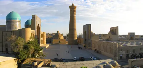
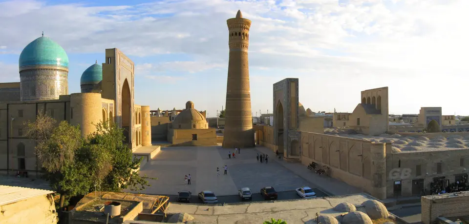
Under the Turkic Karakhanid Khanate from the eleventh century onward, architects added masterpieces of baked brick engineering that still anchor Bukhara's skyline. Master builder Bako raised the Kalyan Minaret (Minara-i Kalan) as a circular tapering brick tower measuring 9 metres across at its base, 6 metres at the summit, and 45.6 metres in height. Inside, a brick spiral staircase climbs to a 16-arched rotunda crowned by a stalactite cornice. Known locally in later legend as the Tower of Death because criminals were reportedly executed from its top, the shaft may adapt ancient pre-Islamic fire-tower proportions visible across flat desert plains. Nearby, the Magok-i-Attari Mosque and the Chashma-Ayub shrine preserve further pre-Mongol and Timurid layers. Linked to legend of the prophet Job striking his staff to bring forth pure water, Chashma-Ayub received an unusual Khwarazm-style conical dome during the reign of Timur after his conquest of 1370.
Shaybanid Civic Ensembles, Trading Domes and the Ark
While individual monuments survived from earlier centuries, the cohesive townscape seen across Bukhara's 216 hectares reflects comprehensive urban planning under the Uzbek Shaybanid dynasty from the early sixteenth century onward. Choosing Bukhara as capital of their khanate, Shaybanid rulers linked monumental mosques, twin madrasas, and crossroads bazaar domes along continuous pedestrian axes. Between the ninth and sixteenth centuries, Bukhara functioned as the Near East's largest Islamic centre for Muslim theology and Sufism, counting over two hundred mosques and more than one hundred madrasas. Spiritual prestige around Sheikh Baha' al-Din Naqshband seeded the Naqshbandi Sufi order, commemorated at the Bahoutdin necropolis complex outside town. Bukhara's markets also drew merchant colonies from as far south as Multan in addition to regional trade networks that long included the Bukhara and Khiva slave trades.
At the monumental heart stands the Po-i-Kalyan ensemble around the base of the Kalyan Minaret. Completed around 1514 to accommodate twelve thousand worshippers, the Kalyan Mosque matches Samarkand's Bibi-Khanym Mosque in footprint. Two hundred and eighty-eight monumental pylons support multi-domed courtyard galleries leading to a cruciform main chamber topped by a blue cupola on a mosaic drum. Directly across the plaza rises the Mir-i-Arab Madrasah (1535 to 1536), raised on a masonry platform to offset a gentle eastern slope. Shaybanid ruler Ubaidullah-khan funded it from the ransom of more than three thousand Persian captives seized during three raids on Herat. Raised in Sufi devotion and named after fifteenth-century Tashkent sheikh Ubaidullah al-Ahrar (1404 to 1490), Ubaidullah-khan chose burial inside a modest wooden tomb within the central vault. Beside him rest his Yemeni mentor Sheikh Abdullah Yamani (Mir-i-Arab) and senior teacher Muhammad Kasim, who died in 1047 hijra.
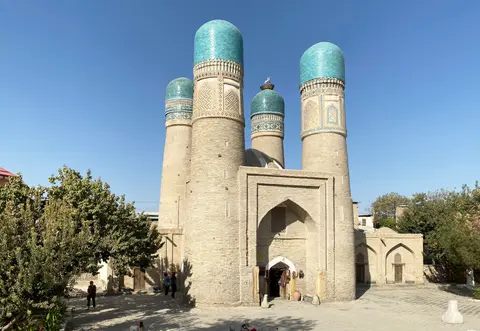
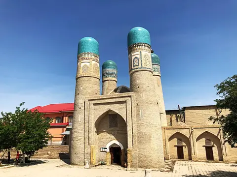
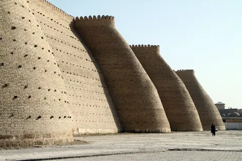
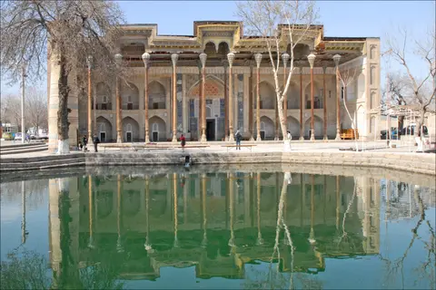
Extending south and east from Po-i-Kalyan, Shaybanid builders linked covered crossroads domes including Taki Sarafon (Dome of the Moneychangers), Taki-Tilpak-Furushan (Dome of the Headguard Sellers), Tim-Bazzazan, and Tiro-Abdullah-Khan. These routes connected paired complexes such as the Kosh Madrasah, the Gaukushon madrasa in the Hodja-Kalon ensemble, the Magoki Kurns Mosque (1637), and the imposing Abdullaziz-Khan Madrasah (1652). At Lyabi-Khauz (1568 to 1622), one of Bukhara's few remaining open water basins survived Soviet drainage campaigns of the 1920s and 1930s because it anchored the huge Kukeldash Madrasah on its north bank. Flanking east and west stand a seventeenth-century Sufi lodging house and madrasa near a bronze figure of folk wit Nasruddin Hodja riding his mule. To the southeast in a quiet lane stands Char Minar, a nineteenth-century four-towered mosque and Sufi ceremonial hall built by wealthy Turkmen patron Khalif Niyaz-kul. Northwest across historic Registan square rises the massive Ark fortress, rebuilt in the sixteenth century and faced by the 1712 Bolo Haouz Friday Mosque and nineteenth-century Boboyi Poradoz Mausoleum behind Salakhona Gate.
Groundwater Salinity, Termite Erosion and State Conservation
By the nineteenth century, Bukhara had shifted to a peripheral frontier under local emirs caught in Great Game rivalries after Agha Mohammad Khan Qajar's final campaigns. The Emirate of Bukhara ended during the Russian Civil War when Red Army units under Mikhail Frunze besieged the city in late August 1920. Emir Mohammed Alim Khan fled on 31 August 1920, and on 2 September 1920 Bolshevik forces damaged the Ark citadel and raised a red flag from the Kalyan Minaret. Following the All-Bukharan Revolutionary Committee formed on 14 September 1920 under A. Mukhitdinov and Fayzulla Xo'jayev, the Bukharan People's Soviet Republic existed from 1920 until 1924. Briefly contested during Enver Pasha's Basmachi campaign of 1922, it was then integrated into the Uzbek Soviet Socialist Republic. Even under Soviet rule, young British diplomat Fitzroy Maclean sneaked into Bukhara in 1938 and likened its domes and brick vaults to Italian Renaissance monuments. Later twentieth-century regional conflicts subsequently brought Dari- and Tajik-speaking refugees into Bukhara's mixed Tajik and Uzbek neighbourhoods.
Although modern concrete insertions between 1920 and the 1950s and seismic shocks scarred parts of the outer quarters, Bukhara retains an extraordinary proportion of medieval streets and public ensembles. Conservation surveys warn, however, that rising underground water levels carry mineral salts upward into baked brick and earthen foundations, while termites severely damage carved timber columns and roof beams. In addition, shrinking use of traditional lime mortars, rising street fill around older monument bases and uncoordinated private repairs in earthen residential quarters threaten historic authenticity.
Statutory protection rests on Uzbekistan's 2001 Law on Protection and Exploitation of Cultural Heritage Properties, the 2005 Bukhara Master Plan and Cabinet of Ministers Decree No. 49 of 23 March 2010, establishing a dedicated State Programme through 2020 for research, structural conservation and lowering streets back toward historic ground levels. Managed by the Ministry of Culture and Sports and the Bukhara Regional Inspection for Protection and Utilization of Monuments of Cultural Heritage, the strategy pairs strict design controls across buffer zones with renewed training in traditional Central Asian masonry and plasterwork.
Complex Access Zones and Historic Precincts in Bukhara
Bukhara's compact 216-hectare core rewards unhurried walking between its four primary monument clusters and historic market domes, where public thoroughfares link directly into courtyard entrances.
| Complex Zone | Key Highlights | Access & Ticket Rule |
|---|---|---|
| Ark Citadel & Registan Precinct | Sixteenth-century royal fortress ramparts, 1712 Bolo Haouz Mosque with wooden-pillared iwan, historic Registan public square | Ark fortress interior and museum collections require admission tickets at the rampart ramp; Bolo Haouz remains an active mosque open respectfully outside prayer times |
| Po-i-Kalyan Ensemble | Twelfth-century Kalyan Minaret (45.6 metres), 1514 Kalyan Mosque, 1535 to 1536 Mir-i-Arab Madrasah | Open central plaza free to enter; Kalyan Mosque charges modest admission while active seminary sections of Mir-i-Arab restrict entry to the vestibule |
| Trading Domes & Lyabi-Khauz Axis | Taki Sarafon, Taki-Tilpak-Furushan, Tim-Bazzazan domes, 1568 to 1622 Lyabi-Khauz pond, Kukeldash Madrasah and Char Minar | Pedestrian bazaar streets, covered domes and the Lyabi-Khauz promenade are open without tickets; artisan workshops and courtyard rooms may request small entry fees |
| Samanid Park & Western Shrines | Ismail Samani Mausoleum (892 to 943), Chashma-Ayub conical dome, Boboyi Poradoz Mausoleum behind Salakhona Gate | Set inside landscaped parklands northwest of the citadel; individual shrine chambers charge small conservation fees for interior access |
Three Structural Details to Examine Across Bukhara
Walking slowly between monuments reveals ingenious medieval masonry and urban engineering visible directly on site:
- Brickwork Sightline Through the Kalyan Mosque Roof Opening: Inside the courtyard galleries of the Kalyan Mosque, look for an intentional opening pierced through one of the multi-domed bay roofs. Stepping slowly backward from beneath the aperture lets observers sight straight through to the base of the Kalyan Minaret and trace each decorative brick band all the way up to the 16-arched rotunda.
- Zoroastrian Solar Brick Patterns on the Ismail Samani Mausoleum: Examine the unglazed baked-brick exterior of the Ismail Samani tomb, where basket-weave relief courses form interlocking circles symbolising solar light. Corner buttresses and an arched upper gallery show how early Islamic builders fused Sasanian decorative motifs into cuboid funerary geometry.
- Raised Platform Compensation at Mir-i-Arab Madrasah: Stand in the centre of the Po-i-Kalyan square between the Kalyan Mosque and the Mir-i-Arab Madrasah. Notice how sixteenth-century architects set Mir-i-Arab upon a raised masonry plinth, counteracting the eastern slope of the square so both monumental portals align across one level axis.
Seasonal Timing and Connecting Bukhara with Samarkand
Bukhara sits in a flat arid oasis where midsummer brings intense daytime heat and winter brings crisp dry cold, making spring and autumn the most comfortable seasons for walking from the western parklands of the Ismail Samani Mausoleum across the trading domes to Char Minar. Early mornings keep the shaded iwans of Bolo Haouz and the brick courtyards of Po-i-Kalyan cool and uncrowded, while late afternoon light warms the unglazed brick textures along the Ark walls.
With Bukhara International Airport (BHK) only 5 kilometres from the old city and rail routes linking directly eastward to Samarkand (217 kilometres away), the two oases pair naturally to show how Timurid monumentality and Shaybanid street planning complemented each other. Continue planning across Uzbekistan with our Samarkand travel guide or compare Central Asian caravan cities across the UNESCO World Heritage Atlas.