Quick Field Data
- UNESCO Inscription: 2001 · Criteria (i), (ii) and (iv) · Ref. 603
- Scale & Footprint: 1,123 hectares across three adjacent historical districts in the Zerafshan River oasis, spanning the northeastern Afrasiab reserve, the medieval Timurid old city and the western nineteenth- and twentieth-century European extension
- Access & Ticketing: Monument precincts such as Registan Square, Gur-i Amir, Shah-i-Zinda and the Afrasiab ruins operate separate ticketed entrances under state reserve management, while residential mahalla lanes remain open on foot
- Arrival Logistics: Reached directly via Samarkand International Airport (SKD, 5 kilometres from the heritage zone) and regular high-speed rail connections across Uzbekistan, 2 kilometres from the Samarkand city centre
Afrasiab, Canal Irrigation and Pre-Mongol Samarkand
Positioned in a broad oasis along the Zerafshan River in southeastern Uzbekistan, Samarkand carries more than two and a half millennia of documented urban growth. Archaeological excavations at Syob, midtown, Hojamazgil and Sazag'on have uncovered Upper Palaeolithic traces dating back 40,000 years, followed by Mesolithic camps from the twelfth to seventh millennia BC at Sazag'on-1, Zamichatosh and Okhalik. Evidence of settled regional life stretches back to 1500 BC, and permanent urbanisation at the Afrasiab mound began around 700 BC, anchored by the artificial Syob and Darg'om water canals cut between the seventh and fifth centuries BC. Following Indo-Iranian migrations in the second millennium BC, the oasis matured into the heart of Sogdian civilisation and became the capital of the Achaemenid satrapy of Sogdia.
When Alexander the Great captured the fortified city in 329 BC, Greek sources recorded its name as Marakanda and installed one Orepius as ruler. Despite heavy initial destruction, Hellenistic masonry transformed local building craft by replacing traditional oblong mud bricks with square bricks and introducing stronger plaster and stone jointing. Successive rule under the Seleucid Empire, the Greco-Bactrian Kingdom and the Kushan Empire sustained this classical synthesis until Kushan authority receded in the third century AD. Around 260 AD, Persian Sasanian forces brought Samarkand under Iranian control and fostered Manichaean communities before nomadic Xionites arrived between 350 and 375 AD, followed by Kidarite power from 457 to 509 and Hephthalite rule.
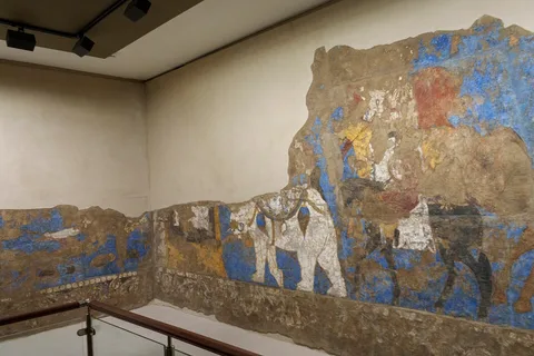
Around 560 AD, allied Göktürk and Sasanian forces defeated the Hephthalites near Bukhara between 557 and 561, bringing the oasis under the Western Turkic Khaganate, whose rulers forged marriage ties with Samarkand's leadership during the reign of Tong Yabghu Qaghan (618 to 630). Excavated seventh-century murals in the royal palace on the Afrasiab mound captured that cosmopolitan court, while Nestorian Christian bishops operated from a fifth-century seat elevated to a metropolitanate by the eighth century together with Zoroastrian, Buddhist, Hindu, Jewish and Manichaean populations. Early medieval Afrasiab stood behind four concentric rings of defensive walls pierced by four gates. After the Umayyad general Qutayba ibn Muslim took Samarkand around 712 AD, garrisoned Arab troops and built a congregational mosque over razed fire temples, the Abbasid commander Abu Muslim erected a multi-kilometre outer wall between 750 and 755. Following the Battle of Talas in 751, Samarkand reportedly established the first paper mill in the Islamic world after acquiring papermaking craft from Chinese prisoners.
Under the Samanid Empire from 875 to 999, Samarkand flourished as a Silk Road emporium and Persian cultural capital. Tenth-century geographer Istakhri described an unbroken expanse of walled gardens, orchards, cisterns, and flowing streams extending eight days' travel through green pastures. When Turkic Karakhanids assumed control in 999, the city became capital of the Western Karakhanid Khaganate from 1040 to 1212. Ibrahim Tamgach Khan (reigned 1040 to 1068) endowed a state-funded madrasa and a public hospital where medicine was taught. Later, the citadel palace of Ibrahim ibn Hussein (1178 to 1202) carried polychrome wall paintings depicting a Turkic warrior in a yellow caftan with hunting dogs and birds. Three major sacred zones grew before the thirteenth century: the congregational mosque quarter, the eleventh-century Qutham ibn Abbas shrine complex at Shah-i-Zinda, and the Chokardiza theologians' cemetery. In 1220, Mongol troops under Genghis Khan sacked the city, killing defenders inside the citadel and mosque and conscripting 30,000 young men and 30,000 craftsmen. Although later looted again by Khan Baraq under the Chagatai Khanate, Samarkand revived sufficiently for Marco Polo and Ibn Battuta, who visited in 1333 and noted orchard irrigation by water wheels, to describe a large, fertile metropolis.
Timurid Imperial Urbanism and Ulugh Beg's Astronomical School
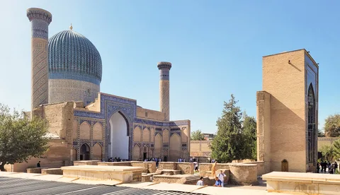
After local citizens rose against Chagatai Mongol rule in the Sarbadar uprising of 1365 centred on Registan Square, Timur made Samarkand the imperial capital of the Timurid Empire in 1370. Over the next 35 years, Timur rebuilt the urban core south of ruined Afrasiab, ringing the city with deep ditches and an 8-kilometre defensive wall while population swelled to roughly 150,000. Sparing skilled architects, masons and calligraphers from conquered territories across Persia, Syria and Central Asia, Timur pushed construction at relentless speed, repeatedly ordering portals rebuilt if proportions displeased him. Castilian ambassador Ruy González de Clavijo, staying in Samarkand from 8 September to 20 November 1404, wrote that the great congregational mosque erected under Timur outshone every other building his embassy visited.
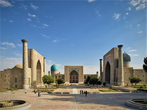
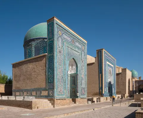
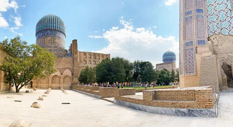
Rather than building atop the ancient mound of Afrasiab, Timurid planners shifted the monumental centre southward into what remains the medieval old town. Here rise the signature ensembles covered in cobalt and turquoise majolica over baked and mud-brick cores. Key ensembles include the Bibi-Khanym Mosque and opposite mausoleum alongside the Gur-i Amir dynastic burial complex and adjacent Rukhabad shrine. They also span the terraced funerary lane of Shah-i-Zinda, where the eleventh-century tomb of Qutham ibn Abbas had survived the Mongol sack. Combining soaring arched pishtaq portals with ribbed turquoise domes and courtyard madrasas, these spatial compositions established architectural formulas later adapted by Safavid builders in Persia, Mughal courts in India, and Ottoman workshops in Turkey.
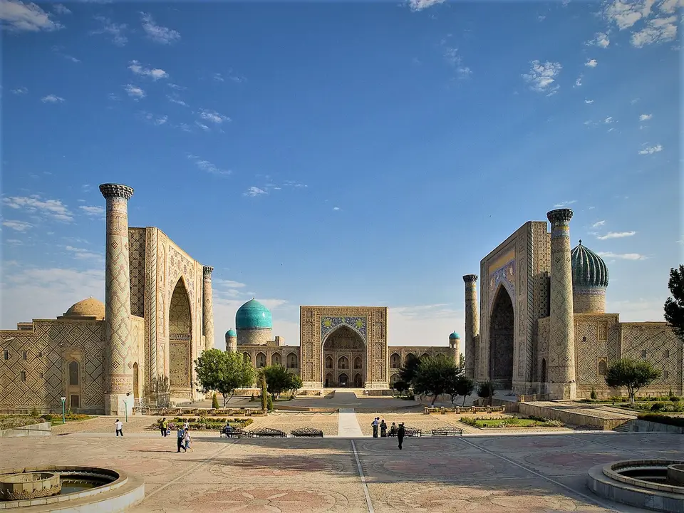
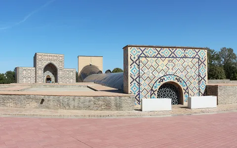
Timur's grandson Ulugh Beg governed Samarkand between 1409 and 1449 and turned the city into a foremost medieval centre of mathematical astronomy. Between 1417 and 1420, he built the great madrasa that anchored the western flank of Registan Square, gathering scholars including Jamshid al-Kashi, Qadi Zada al-Rumi and Ali Qushji. In 1428, Ulugh Beg constructed an observatory northeast of the city housing a unique marble wall quadrant known as the Fakhri Sextant, measuring 40 metres in radius and flanked by parallel staircases for assistant observers measuring solar and stellar altitudes. After Uzbek Shaybanid forces under Muhammad Shaybani took Samarkand between 1500 and 1501 and briefly crowned him capital ruler of the new Bukhara Khanate, later Uzbek rulers retained Samarkand's monumental scale and madrasa patronage while shifting primary political administration west to Bukhara.
Domestic Courtyards, Russian Expansion and Heritage Management
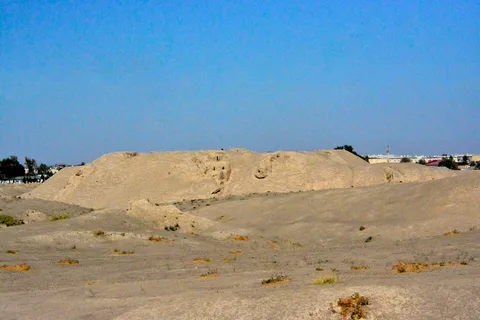
Beyond monumental madrasas and mausoleums, Samarkand's inscribed 1,123 hectares encompass surviving vernacular mahalla neighbourhoods and a distinct nineteenth-century European quarter. Traditional Uzbek houses inside the old city rise one or two storeys around planted interior courtyards, built in mud brick with carved, painted wooden ceilings and decorated plaster rooms. These homes are organised around small neighbourhood social centres and local mosques. Because Samarkand expanded horizontally over centuries rather than obliterating older layers, visitors can trace three successive city footprints side by side. Unbuilt archaeological hills mark Afrasiab in the northeast, while medieval Timurid and Shaybanid street networks spread to the south. To the west stretch wide tree-lined avenues with early twentieth-century Orthodox churches and administrative blocks from the Russian imperial and Soviet eras.
Samarkand served as the first capital of the Uzbek Soviet Socialist Republic from 1925 to 1930 before administrative functions moved to Tashkent. Modern Samarkand has grown into Uzbekistan's second-largest city with 882,000 inhabitants as of 2026. Bilingual Tajik speakers form a major historic community across the city alongside Uzbek as the official state language and widespread Russian in civic administration. Heritage preservation operates under the State Samarkand Historical Architectural Reserve, established by Cabinet of Ministers Decree on 26 May 1982. Joint oversight unites the Ministry of Culture and Sports, Samarkand provincial and municipal authorities, the Principal Scientific Board, and the Samarkand Regional State Inspection on Protection and Utilization of Cultural Heritage Objects.
Sustained conservation balances monument maintenance against rapid urban pressures. While primary domes and tiled facades stand in stable condition, parts of the medieval outer wall, the historic citadel and traditional mud-brick courtyard dwellings immediately bordering major monuments have suffered past losses. Conservation specialists continue working to prevent unpermitted modern building inside historic mahallas, keep restoration work aligned with international conservation standards rather than over-rebuilding, and tie buffer-zone rules directly into city planning.
Complex Access Zones and Monument Rules in Samarkand
Navigating Samarkand works best by dividing the inscribed 1,123-hectare zone into its distinct historical and architectural areas, each managed with separate entry checkpoints and walking loops.
| Complex Zone | Key Highlights | Access & Ticket Rule |
|---|---|---|
| Afrasiab Reserve & Ulugh Beg Observatory | Seventh-century BC Sogdian mound, seventh-century palace wall paintings, ancient eighth- to twelfth-century mosque foundations, 1428 Fakhri Sextant trench | Fenced archaeological park and museum requiring separate entry tickets at the reserve gate and observatory pavilion; open daylight access on marked paths |
| Registan Square & Bibi-Khanym Precinct | Ulugh Beg Madrasah (1417 to 1420), Timurid congregational Bibi-Khanym Mosque and mausoleum opposite, market axis linking medieval quarters | Ticketed monuments with controlled security perimeter around Registan Plaza; modest dress required inside prayer spaces and courtyards |
| Shah-i-Zinda & Gur-i Amir Ensembles | Eleventh-century Qutham ibn Abbas shrine, Timurid cobalt and turquoise mausoleum lane, Gur-i Amir dynastic tomb and Rukhabad precinct | Separate admission ticket booths at each complex; active pilgrimage etiquette applies around graves and inner domed chambers |
| Traditional Mahallas & Western Russian Quarter | Courtyard mud-brick houses with painted wooden ceilings, neighbourhood mosques, nineteenth-century European street grid and Orthodox churches | Open pedestrian street network free to walk at all hours; private courtyard homes and active parish churches require local permission or respectful timing |
Three Architectural Details to Notice in Samarkand
Walking closely among the tiled portals shows how Samarkand's builders solved structural, astronomical and decorative problems across successive dynasties:
- Subterranean Trench of the Fakhri Sextant at Ulugh Beg's Observatory: In 1428, astronomers avoided warping-prone wooden or brass instruments by excavating a curved limestone trench into the hillside bed to stabilise the 40-metre radius marble meridian arc. Twin stone staircases flank the trench so assistants could read noon solar elevations to fine angular tolerances without wind disturbance.
- Mud-Brick Core Construction Beneath Glazed Majolica at Registan and Bibi-Khanym: Where damaged sections or restoration seams reveal structural masonry, notice how Timurid masons raised massive vaults and pishtaq portals out of sun-dried mud brick and fired brick. They then sheathed surfaces in cobalt and turquoise ceramic tiles fitted to absorb thermal expansion and seismic vibration.
- Stratified Wall Murals of Seventh-Century Sogdian Afrasiab: Inside the Afrasiab museum hall, study the excavated royal reception room paintings depicting foreign ambassadors arriving by horse, camel, and elephant with river processions. Compare these pre-Islamic Sogdian pigments with the twelfth-century Karakhanid warrior fragment discovered in the citadel palace of Ibrahim ibn Hussein.
Seasonal Timing and Linking Samarkand with the Regional Atlas
Because Samarkand sits in a continental oasis basin along the Zerafshan Valley, spring and autumn bring mild daytime temperatures suited to walking the open Afrasiab mound, climbing the stairways of Shah-i-Zinda and crossing between Registan Square and Bibi-Khanym without midsummer heat or winter frost. Early morning visits offer calm courtyards at Gur-i Amir and clear natural light across eastern-facing tile facades before tour groups gather.
With Samarkand International Airport (SKD) just 5 kilometres from the historic core and fast rail links crossing the country, Samarkand anchors any journey across Central Asia's Silk Road cities. Travellers planning onward routes can explore practical city logistics in our Samarkand destination guide before comparing oasis urbanism and medieval brick architecture across the wider UNESCO World Heritage Atlas.