


























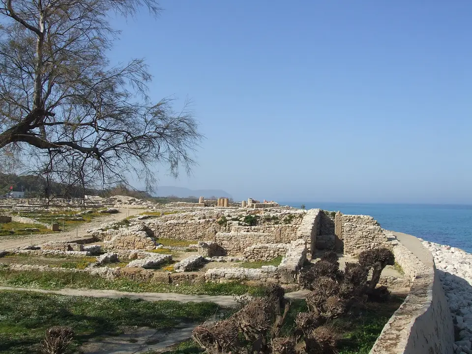
Quick Field Data
- UNESCO Inscription: 1985, inscribed as the only known example of a Phoenician-Punic city to have survived in the Mediterranean without being rebuilt by the Romans.
- Scale & Footprint: Occupies a coastal cliff promontory on the tip of the Cape Bon peninsula alongside the Arg el Ghazouani necropolis atop a coastal hill under one kilometre away in Nabeul Governorate.
- Access & Ticketing: Managed as a fenced seaside archaeological park with an on-site museum displaying Punic grave goods and ceramics; check the official site for current admission policies.
- Arrival Logistics: Situated on the northeastern coast of the Cape Bon peninsula in Nabeul Governorate, accessible by road across the peninsula from Tunis.
Perched on a low limestone cliff overlooking the turquoise waters of the Mediterranean near the northeastern tip of the Cape Bon peninsula in Tunisia, the Punic Town of Kerkuane and its Necropolis (also spelled Kerkouane) preserve a unique archaeological time capsule of the Carthaginian world. Throughout Tunisia, the UNESCO World Heritage Atlas in 1985, this coastal settlement existed for nearly 400 years from the sixth century BC until it was abandoned around 250 BC during the First Punic War in the western Mediterranean. Unlike great Phoenician and Punic metropolises such as Carthage, Tyre, Byblos, Utica, or Hadrumetum (modern Sousse), where subsequent Roman conquerors levelled or built directly over the earlier streets, Kerkuane was never reoccupied after its mid-third-century BC destruction. Consequently, travellers driving east from Tunis across the orchards of Nabeul Governorate walk through the only purely Phoenician-Punic urban grid to survive intact anywhere around the Mediterranean basin. Sea breezes sweep across the coastal ruins.
Discovery in 1952, the First Punic War, and Murex Purple Industry
For more than two millennia after its abandonment, the ruins of this cliffside Punic town lay buried beneath coastal sand drifts and thorny scrub along the eastern shore of Cape Bon. Because no surviving Greek or Roman historical text records the ancient Phoenician name of the settlement, when archaeologists from the National Institute of Archaeology and Art discovered the site in 1952 and launched systematic excavations under the National Institute of Archaeology and Art, they named the ruins Kerkuane after the local Berber toponym (derived from the Berber verb kkerker, meaning to wall up or pile stones, a root also found across Algeria and the Sahel).
Ceramic and stratigraphic finds from the deepest layers indicate that Phoenician settlers first established an outpost on the promontory in the sixth century BC, trading with indigenous Libyan communities and passing Mediterranean merchant vessels. The visible urban layout and ramparts alongside domestic quarters excavated across the cliffside date primarily from the late fourth century and the first half of the third century BC, when Kerkuane flourished as a prosperous satellite port within the maritime empire of Carthage. Around 250 BC, during the First Punic War around 250 BC, the town was abandoned and never rebuilt.
With a population estimated at roughly 1,200 inhabitants, Kerkuane was home to a thriving community of fishermen and craftsmen. Excavations uncovered vast middens of crushed murex sea-snail shells alongside rock-cut vats and furnaces on the edge of the settlement, proving that Kerkuane was a major centre for extracting prized purple dye for textiles. In addition to purple dye, the town produced sea salt and fermented fish sauce (garum) for export across the western Mediterranean, importing Greek fine pottery in return, highlighted by an imported black-figure ceramic jug painted with an episode from the Odyssey discovered alongside an Ionian cup.
Orthogonal Town Planning, Opus Signinum Bathrooms, and the Punic Sanctuary
Walking through the excavated streets of Kerkuane challenges the long-held classical stereotype that orthogonal urban planning and domestic hygiene in North Africa were absent from Carthaginian cities. Enclosed on its landward side by a double horseshoe-shaped defensive rampart separated by an intervening ditch and pierced by staggered gateways, the town is laid out on a planned grid of wide, straight thoroughfares intersecting open public squares. Clay-lined drainage channels and stone curbstones run along the streets to carry rainwater and domestic runoff toward the sea cliff.
Every residential block consists of houses built to a standardized Punic courtyard plan that prioritized domestic privacy and cleanliness. Entered from the street through an angled vestibule corridor that prevented passers-by from peering into the interior, each house opens onto a central sunlit courtyard (sometimes framed by Greek peristyle columns and coloured clay or white stucco wall plaster) equipped with a freshwater well and cistern. Nearly every private dwelling in Kerkuane features its own dedicated bathroom with a fitted hip-bath (sabot bath) complete with a built-in seat and washbasin alongside a drainage channel.
The floors of these bathrooms and thresholds are paved in the distinctive Punic mosaic technique known to the Romans as opus signinum (pavimenta punica): a durable pink-red mortar mixed with crushed terracotta tiles and inlaid with white marble tesserae arranged in geometric patterns and protective symbols of the goddess Tanit (the triangular anthropoid sign topped by a horizontal bar and solar disc) to ward off evil spirits at the threshold. In Tunisia, the centre of town stands the largest known Punic temple sanctuary in North Africa: entered through a pillared vestibule, its courtyard houses a sacrificial altar, an area for ritual banquets, craft workshops, and small mosaic fragments. Terracotta figurines found inside the temple, including two male heads wearing conical hats that resemble iconography from the Temple of Antas in Sardinia, suggest the sanctuary honoured the Phoenician-Punic deities Melqart and Sid alongside Tanit.
The Necropolis of Arg el Ghazouani and Coastal Conservation
Less than one kilometre inland from the town walls, carved into a rocky limestone hill overlooking the coast, lies the Necropolis of Arg el Ghazouani, the best-preserved sector of the wider Punic burial grounds scattered across the hills of Cape Bon. Reached by narrow stepped corridors (dromoi) cut steeply down into the bedrock, the subterranean chamber tombs contain stone benches where the deceased were laid to rest alongside pottery vessels and funerary offerings. Traces of red ochre smeared inside several burial chambers demonstrate how Carthaginian funerary architecture at Kerkuane absorbed indigenous Berber burial customs.
Walking along the cliffside streets of Kerkuane offers a rare opportunity to experience the domestic and religious life of the Carthaginian world without the overlay of later Roman urbanism. Every straight thoroughfare, public square, courtyard house, and pink crushed-terracotta bathroom floor reflects the sophisticated municipal standards achieved by Punic town planners before the First Punic War. Together with the rock-cut chamber tombs of the nearby Arg el Ghazouani necropolis on the coastal hills of Cape Bon, the seaside ruins provide an unmatched window into Phoenician-Punic civilisation in the western Mediterranean.
Because Kerkuane sits directly on an exposed, low-lying coastal cliff, the site faces ongoing natural erosion from winter waves and future sea-level rise highlighted in the 2022 IPCC Sixth Assessment Report. Exploring the seaside ruins, the on-site museum, and the cliffside ramparts takes roughly two hours on foot. Because the Romans never rebuilt over the ruins after the First Punic War, the stone foundations, domestic peristyles, and purple-dye workshops along the Mediterranean shore preserve a complete snapshot of Phoenician-Punic urban planning, and walking along the coastal cliffs of the Cape Bon Peninsula reveals how the orthogonal streets, courtyard houses, private hip-baths, and waterproof opus signinum floors survived untouched alongside the rock-cut chambers of the Arg el-Ghazouani necropolis and the onsite archaeological museum.
- Look for the protective symbol of Tanit on house thresholds: As you walk down the main residential streets, pause at the stone doorways to spot the triangular white-tesserae emblem of the goddess Tanit inlaid into the red crushed-terracotta floors beside the built-in Punic hip-baths.
- Trace the landward ramparts and coastal dye vats: Walk the outer perimeter path from the double defensive walls and gates on the inland side out to the edge of the sea cliff, where rock-cut dye basins and coastal foundations drop directly toward the Mediterranean surf.
- Visit the site museum before walking the excavated streets: Start inside the small garden museum at the entrance to see the fourth-century BC black-figure Odyssey wine jug, conical-hatted terracotta heads of Sid and Melqart, and carved wooden coffin remains recovered from the Arg el Ghazouani tombs.
