


























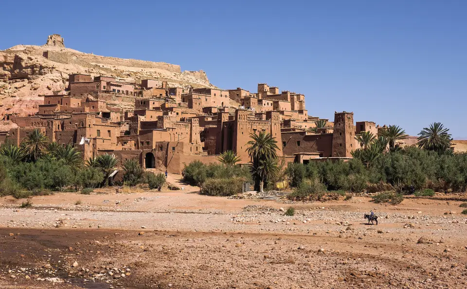
Quick Field Data
- UNESCO Inscription: Inscribed in 1987 (criteria iv, v) as a fortified earthen village (ksar) in Ait Zineb, Ouarzazate Province, Morocco.
- Scale & Footprint: A 3.03-hectare core property surrounded by a 16.32-hectare buffer zone along the south-facing foothills of the High Atlas along the Ounila River (Asif Ounila).
- Access & Ticketing: Reached via a pedestrian bridge completed in 2011 from the modern village across the river; check the official site or local conservation notices before visiting.
- Arrival Logistics: Located southeast of Marrakech across the High Atlas Mountains via the Tizi n'Tichka or historic Tizi-n'Telouet pass routes toward Ouarzazate.
Rising in stepped tiers of red-ochre earth against the southern foothills of the High Atlas in Ouarzazate Province, the Ksar of Ait-Ben-Haddou (known in Berber as an ighrem) is the most complete surviving example of pre-Saharan earthen architecture in southern Morocco. Positioned on a hillside above the Ounila River (Asif Ounila) along the ancient caravan corridor that linked Sudan and the edge of the Sahara through the Dra Valley (Dra Valley) and the Tizi-n'Telouet and Tizi n'Tichka passes to Marrakech across the mountain passes, the site has served as a fortified waypoint from the 11th-century Almoravid era onward. Although none of the standing structures appear to date earlier than the 17th century, every wall, corner tower, and courtyard house was raised using construction methods and spatial layouts practiced across the southern Moroccan valleys for centuries. In 1987, the UNESCO World Heritage Atlas in 1987 across a 3.03-hectare core zone and a 16.32-hectare buffer zone, the ksar illustrates how collective defence, trans-Saharan commerce, and oasis agriculture shaped settlement design on the desert fringe.
Unlike an isolated fortress, a southern Moroccan ksar is a tightly integrated walled community where domestic, religious, and commercial functions share a compact defensive perimeter. Reinforced by angled corner towers and entered through a bent baffle gate designed to slow attackers, the perimeter ramparts enclose a dense cluster of dwellings ranging from modest family homes to tall, turreted urban castles (kasbahs) whose upper walls are patterned with geometric motifs in sun-dried clay brick. Alongside these houses, the historic ensemble preserves a full set of communal institutions: a mosque, a public square, a caravanserai for passing camel caravans, grain-threshing floors outside the ramparts, both a Muslim cemetery and a Jewish cemetery, the Sanctuary (Marabout) of the Saint Sidi Ali or Amer, and a fortified communal granary and loft (agadir) crowning the summit of the hill.
Rammed Earth, Adobe Upper Storeys, and Caravan Geometry
The visual harmony of Ait-Ben-Haddou comes directly from its reliance on four local materials: rammed earth, adobe, clay bricks, and timber. Builders formed the lower load-bearing walls and defensive bastions using rammed earth, known regionally as pise, tabia, or al-luh, by compressing damp earth and mud mixed with chopped straw between wooden formwork boards. To reduce the dead weight pressing down on these lower walls, masons switched to lighter sun-dried adobe bricks for the upper storeys and corner turrets, laying small clay bricks at angles to create geometric friezes, blind arcades, and ventilation lattices that filter the intense pre-Saharan sun while allowing air to circulate through the suspended interior living quarters.
This structural system was both cost-effective and thermally suited to the arid Ounila Valley, where neighboring ksour and kasbahs such as Tamdaght to the north once formed a continuous chain of defensive waystations. However, because earthen walls bound with straw are permeable and vulnerable to seasonal rainstorms, they require regular replastering with fresh mud slurry; when a ksar is abandoned, its towers can crumble back into the hillside within a few decades. As trans-Saharan caravan trade declined and valley transport shifted in the 20th century, most residents moved across the Ounila River into modern concrete houses connected to road and utility networks, leaving only a few families inhabiting the historic ksar itself until a pedestrian bridge completed in 2011 reconnected the two banks.
Climbing from the Ounila Riverbed to the Hilltop Agadir
Approaching Ait-Ben-Haddou from the modern village on the opposite bank gives a sweeping panoramic view of how the tiered kasbah towers step up the steep slope between the river bed and the ruined hilltop granary. Crossing the 2011 pedestrian bridge (or stepping across the shallow stones of the Ounila River in dry weather) brings you directly to the baffle gate in the outer rampart. Inside, a labyrinth of narrow, covered earthen alleyways and stepped lanes winds upward between the high windowless lower walls of the merchant kasbahs toward the open upper terraces and the summit agadir.
- Cross the High Atlas early from Marrakech: If travelling the mountain route from Marrakech over the Tizi n'Tichka pass and down the Ounila Valley past Tamdaght, arrive in the early morning or late afternoon when low sunlight brings out the deep relief of the clay-brick geometric motifs on the corner towers.
- Trace the communal anatomy of the ksar: Rather than walking only a single path to the top, look for the public square, the former mosque and caravanserai zones, the external grain-threshing areas, the Sanctuary of Sidi Ali or Amer, and the historic Muslim and Jewish cemeteries that made the village self-sufficient.
- Climb to the fortified loft (agadir) and respect seismic repairs: Ascend the upper path to the hilltop fortification and granary for views across the Ounila oasis and High Atlas foothills, and check the official site or local management notices to stay clear of any alleys undergoing structural consolidation after the September 2023 earthquake.
To understand why the Ksar of Ait-Ben-Haddou has endured as the pre-eminent symbol of southern Moroccan architecture in the Ounila Valley, it helps to look closely at how pre-Saharan oasis settlements balanced defence, climate, and community life. Earth and straw shaped every wall. Across the south-facing foothills of the High Atlas inside Ouarzazate Province, caravan towns grew along the river valleys that fed into the Dra Valley and led northward over the Tizi-n'Telouet and Tizi n'Tichka passes toward Marrakech. Merchants carrying gold, salt, and goods from ancient Sudan required fortified halting places where camels could be quartered in a secure caravanserai, grain could be threshed on open floors outside the ramparts and stored in a hilltop agadir loft, and families could shelter behind high rammed-earth curtains reinforced by angle towers and a bent baffle entrance.
Within the 3.03-hectare core property and its 16.32-hectare buffer zone in Ait Zineb, the spatial hierarchy of the village remains immediately legible even though most local inhabitants now reside in modern houses across the Asif Ounila river and work in agriculture and tourism. Modest single-family earthen houses press shoulder to shoulder along the lower lanes, while the tall corner-towered kasbahs rise like miniature urban castles above the public square and mosque. On the upper storeys of these kasbahs, masons switched from heavy compressed mud (pise, tabia, or al-luh) to lighter sun-dried clay bricks, arranging geometric reliefs and small apertures that shed rainwater and vent hot air from the closed, suspended living rooms below. Outside the defensive wall, the presence of both a Muslim cemetery and a Jewish cemetery alongside the Sanctuary (Marabout) of the Saint Sidi Ali or Amer records the multi-confessional history of the southern Moroccan caravan valleys before 20th-century depopulation shifted daily life across the river.
Film Heritage, Earthen Maintenance, and Post-2023 Recovery
In the late 20th and modern era, income from heritage tourism and international film and television productions, including major historical epics and series such as Game of Thrones, Outer Banks, O Clone, and season 6 of The Amazing Race Australia, helped fund the ongoing mud-plastering and timber-beam replacement needed to keep Ait-Ben-Haddou standing. Supervised by a local management committee, restoration artisans have preserved the ksar's material authenticity by using traditional pise, adobe, and wood techniques while excluding new concrete structures from the 3.03-hectare core zone.
That commitment to traditional earthen craftsmanship faced a severe test in September 2023, when the powerful earthquake that struck southern Morocco and the High Atlas caused structural cracks and partial collapses across sections of the ksar, creating risks of further wall failures during subsequent rains. Ongoing conservation work relies on the same generational knowledge of rammed earth and clay-brick masonry that first raised these towers in the 17th century. Walking quietly through the shaded earthen passages between the Ounila River and the hilltop agadir shows how pre-Saharan communities turned the soil beneath their feet into enduring fortress architecture.
