


























Quick Field Data
- UNESCO Inscription: 1996
- Scale & Footprint: 940,900 hectares (approximately 9,400 square kilometres or 3,600 square miles) across Gällivare, Arjeplog, and Jokkmokk municipalities in Lapland, Sweden
- Access & Ticketing: 95% protected across four national parks and two nature reserves with open backcountry access and an entry information centre at the village of Porjus; check the official site
- Arrival Logistics: Situated north of the Arctic Circle in northernmost Sweden, approached through the gateway village of Porjus and the municipal hubs of Jokkmokk, Gällivare, and Arjeplog
Ancestral Reindeer Transhumance North of the Arctic Circle
Spanning 940,900 hectares (approximately 9,400 square kilometres or 3,600 square miles) across Gällivare Municipality, Arjeplog Municipality, and Jokkmokk Municipality in the Lapland province of northernmost Sweden, the Laponian Area, also called Laponia from the Latin name for Lapland, is the largest unmodified natural landscape in the world still culturally shaped by indigenous reindeer herders. After 1996, the UNESCO World Heritage List in 1996 under five mixed criteria after the bulk of its territory had enjoyed statutory protection since the early 20th century, the region lies within the Arctic Circle across the northern Fennoscandian mountain and forest belt. While the indigenous Saami (Sami) people inhabit Arctic and subarctic territories across northern Norway, northern Sweden, Finland, and Russia, Laponia preserves one of the last, largest, and best-preserved surviving examples of seasonal livestock transhumance, an ancestral pastoral tradition of seasonal herd migration that was once common across the northern hemisphere but has been rendered obsolete or abandoned in most other parts of the world.
Human presence across these high mountains, lakes, marshes, and river valleys dates back thousands of years. Although the region was probably first entered as the last Ice Age receded around 10,000 years BP, documented archaeological finds confirm that early human groups arrived in the Laponian Area between 6,000 and 7,000 years ago. Across succeeding millennia, early hunting and fishing bands developed the seasonal reindeer-herding economy that still links the eastern winter forests with the western alpine summer pastures today. The landscape remains a living homeland.
Every summer, Saami herding communities lead their large herds of reindeer up through the river valleys towards the western mountains across this vast wilderness. Only parts of the 9,400-square-kilometre expanse are used for pasture at any single time, allowing alpine tundra and forest lichens to regenerate across seasonal cycles. In the contemporary era, this ancestral transhumance landscape navigates modern infrastructure pressures noted in World Heritage documentation, including the introduction of motor vehicles in herding operations, the presence of three major hydropower stations with their associated reservoir basins, and plans for a large expansion of 100 wind power stations within the World Heritage boundary.
Four National Parks, Two Nature Reserves, and the Rapa River Delta
Ninety-five percent of the Laponian Area enjoys statutory conservation status across four contiguous national parks (Muddus, Sarek, Padjelanta / Badjelánnda, and Stora Sjöfallet) together with two expansive nature reserves (Stubba and Sjaunja). The other 5% of the World Heritage territory covers the adjacent alpine and valley sectors of Sulitelma, Tjuoltadalen, and the lower Rapadalen valley (part of which falls inside Sarek National Park). Together, these conservation units span a vast west-to-east geological and ecological gradient across northern Fennoscandia, where historical and ongoing geological, biological, and ecological processes can be observed directly in glacial moraines, braided river deltas, primeval boreal forests, vast marshes, and shifting watercourses.
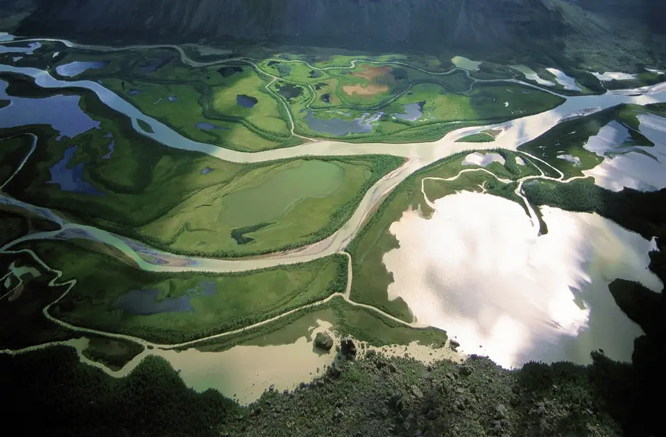
In the western mountains, Sarek National Park forms the rugged alpine heart of Laponia, a roadless expanse of snow-covered peaks, hanging glaciers, and deep glacial valleys crowned by Sarektjåhkkå, the highest mountain of the Laponian Area at 2,089 metres (6,854 feet). Cutting through Sarek is the Rapa Valley (Rapadalen), where sediment-rich glacial meltwater builds the sweeping Rapadelta beneath the cliff face of Skierffe. Immediately west of Sarek, Padjelanta / Badjelánnda National Park opens into an elevated plateau of rolling alpine meadows, summer Saami settlements, and immense mountain lakes, while Stora Sjöfallet National Park straddles the central alpine divide.
Descending eastwards from the high mountain range into the boreal forest zone, Muddus National Park and the neighbouring Stubba and Sjaunja Nature Reserves protect ancient pine and spruce woodlands, deep canyon gorges, and expansive peat marshes and mires. Across this varied geography dominated by mountains, rivers, and lakes, heavy winter snow and substantial summer rainfall sustain a rich diversity of flora and fauna characteristic of the northern Fennoscandian region, with each national park and nature reserve displaying its own distinct landforms and habitats.
The contrast between the western alpine peaks of Sarek and Padjelanta and the eastern lowland forests and wetlands of Muddus, Sjaunja, and Stubba mirrors the annual cycle of the Saami reindeer herds. In spring and summer, the herds move westwards into the high, wind-swept valleys and lake basins of Padjelanta and Sarek where cool mountain air and rich alpine grazing sustain the animals, before returning eastwards in autumn towards the sheltered coniferous forests and mire margins of Jokkmokk, Gällivare, and Arjeplog for the long Arctic winter. Because the 940,900-hectare Laponian Area was inscribed under both cultural criteria (iii and v) and natural criteria (vii, viii, and ix), its management balances the conservation of glacial landforms, primeval boreal forests, and Fennoscandian wildlife with the living pastoral traditions of the reindeer-herding Saami communities who have stewarded these valleys for millennia.
Entering Laponia Through Porjus and Hiking the Arctic Backcountry
Travellers planning a journey with the UNESCO World Heritage Atlas can begin at the village of Porjus in Jokkmokk Municipality, which acts as the primary eastern gateway to the Laponian Area and operates a dedicated visitor information centre. Because the 940,900-hectare wilderness extends across Gällivare, Arjeplog, and Jokkmokk municipalities, visitors select their approach according to the specific national park or nature reserve they intend to explore: Muddus, Stubba, and Sjaunja for primeval forest and marsh trails in the east, Padjelanta for open alpine lake walks in the west, or Sarek for self-reliant alpine trekking.
Each park requires careful preparation for subarctic weather and long distances between settlements. While Padjelanta, Stora Sjöfallet, and Muddus provide marked summer footpaths and seasonal cabins, Sarek National Park has no marked trails or tourist huts beneath the 2,089-metre summit of Sarektjåhkkå, demanding full wilderness self-sufficiency when hiking through Rapadalen and past the Rapadelta below Skierffe. Walkers crossing the summer mountain pastures must respect active Saami reindeer herding by giving grazing herds and working herders a wide berth across the open tundra and valley trails.
Seasonal conditions across the 9,400-square-kilometre Laponian Area vary dramatically between the snowbound Arctic winter and the bright summer months when rainfall swells the mountain rivers and deltas. Travellers exploring the eastern boreal woodlands and vast wetlands of Muddus National Park, Sjaunja Nature Reserve, and Stubba Nature Reserve experience primeval forests and quiet mires that contrast sharply with the glacier-carved valleys of Sarek, the expansive alpine lakes of Padjelanta / Badjelánnda, and the high mountain corridors of Stora Sjöfallet, Sulitelma, and Tjuoltadalen. Whether beginning a walk at the Porjus information centre in Jokkmokk Municipality or approaching from Gällivare or Arjeplog, visitors encounter a vast subarctic landscape where ongoing geological processes and living Saami pastoral traditions coexist across 940,900 hectares of protected mountains, rivers, marshes, and lakes. Linking the braided channels of the Rapadelta beneath Skierffe in the Rapa Valley and the 2,089-metre ice-clad peak of Sarektjåhkkå with the vast alpine waters of Padjelanta and the primeval forest gorges of Muddus, every sector of Laponia illustrates why 95% of this Arctic expanse is conserved as national parks and nature reserves while remaining an active summer grazing homeland for Saami reindeer herds. Across Gällivare, Arjeplog, and Jokkmokk municipalities, this balance of unmodified Arctic nature and living Saami cultural stewardship defines Laponia as one of the world's foremost mixed World Heritage landscapes.
- Starting at the Porjus information centre: Visit the information centre in the gateway village of Porjus before entering the parks to check trail conditions, seasonal river crossings, and exhibits on Saami culture and the Swedish National Heritage Board management framework.
- Matching parks to hiking experience: Choose Padjelanta/Badjelánnda or Muddus National Park for established trail routes, and reserve Sarek National Park and the Rapa Valley for fully self-supported wilderness expeditions.
- Respecting Saami reindeer herds: Keep a respectful distance from grazing reindeer herds across the summer mountain pastures so that seasonal herding movements proceed without disturbance.
