


























Quick Field Data
- UNESCO Inscription: 1980 (extended 1992, minor boundary modification 2015) · Criterion (iv).
- Scale & Footprint: Seven megalithic temples across six protected archaeological complexes (Ġgantija on Gozo alongside Tarxien, Ħaġar Qim, Mnajdra, Ta' Ħaġrat, and Skorba on Malta) covering 3.155 hectares with a 167-hectare buffer zone
- Access & Ticketing: Managed by Heritage Malta; visitor centres and protective conservation canopies shelter the globigerina limestone complexes at Ħaġar Qim alongside Mnajdra and Tarxien, while Ġgantija on the Xagħra plateau and the rural sites at Mġarr and Żebbiegħ welcome ticketed visitors on foot
- Arrival Logistics: Distributed across the main island of Malta (in Tarxien near the Grand Harbour, Qrendi and Siġġiewi on the southern coast, and Mġarr and Żebbiegħ in the northwest) and the Xagħra plateau on the sister island of Gozo
Neolithic Evolution and Trilithon Megalithic Engineering
Constructed across the islands of Malta and Gozo during the 4th and 3rd millennia BC (specifically between roughly 3600 BC and 2500 BC within a broader prehistoric sequence spanning 5200 to 2500 BC), the Megalithic Temples of Malta (It-Tempji Megalitiċi ta' Malta) rank among the oldest freestanding stone buildings anywhere on Earth, surpassed in age only after the late-twentieth-century excavation of Göbekli Tepe in Turkey. First In the World Heritage List in 1980 for the two gigantic structures of Ġgantija on the island of Gozo, the serial property was extended in 1992 (with boundary adjustments in 2015 across 3.155 hectares and a 167-hectare buffer zone) to incorporate five additional temple complexes on the island of Malta: Ħaġar Qim and Mnajdra (in Qrendi), Ta' Ħaġrat (in Mġarr), Skorba (in Żebbiegħ), and Tarxien (in Tarxien). Across these six complexes stand seven principal temples that evolved entirely through local cultural innovation on an isolated island archipelago with limited natural resources. Megaliths rose before the pyramids.
Understanding the chronological depth of the Maltese temples required overturning nineteenth-century assumptions that prehistoric islanders must have copied Aegean models. When pioneering Maltese archaeologist Sir Temi Żammit excavated Tarxien in the early twentieth century and Ta' Ħaġrat from 1925 to 27, he proposed dates of 2800 BC for the Neolithic temples and 2000 BC for the overlying Tarxien Bronze Age cemetery, dates that contemporary European scholars dismissed as half a millennium too early. Subsequent calibrated radiocarbon dating proved Żammit right and pushed the origins even deeper: human settlement on the islands began in the Early Neolithic (around 6500 BC) and the Għar Dalam phase (around 5000 BC, confirmed by a 4850 BC radiocarbon date on charcoal and baked daub alongside carbonised grain against an eleven-metre-long straight wall at Skorba). Within the Temple Period (roughly 4100 BC to 2500 BC), monumental stone construction flourished across three primary architectural phases: the Ġgantija phase (3600 to 3200 or 3000 BC), the transitional Saflieni phase (3300 to 3000 BC, named after the subterranean Hypogeum of Ħal-Saflieni and noted for biconical bowls), and the culminating Tarxien phase (3150 to 2500 BC), after which the temple-building culture abruptly vanished.
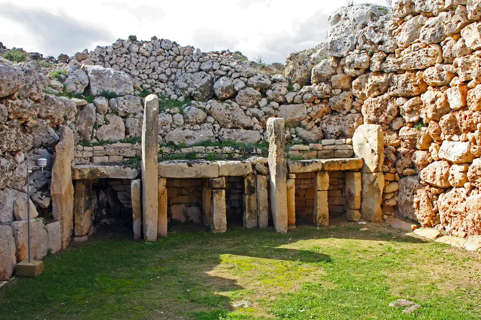
While each of the roughly thirty megalithic temples documented across the archipelago varies in length (from 6.5 metres in the Mnajdra east temple to 23 metres in the six-apsed Tarxien central temple) and in internal layout, they share a sophisticated structural grammar developed from two local limestones of contrasting hardness. For external boundary walls exposed to structural stress and weather, Neolithic engineers quarried hard, rough coralline limestone, setting massive blocks alternately face-out and edge-out to tie the outer shell into a rubble-and-earth core packed with pottery shards. For internal apse walls alongside trilithon doorways and carved reliefs, they selected softer, golden globigerina limestone that could be dressed smoothly with stone tools.
Each temple is approached across a levelled oval or elliptical forecourt fronting a concave stone façade oriented south or southeast. Both the concave façade and the interior walls are constructed of upright stone slabs set on end, known as orthostats, surmounted by horizontal ashlar courses that corbelled inward to support a roof capped by horizontal beams. Within Malta, the centre of façade, a monumental trilithon entrance (two vertical orthostats supporting a heavy horizontal lintel) leads along a stone-paved axial passage into successive pairs of D-shaped lateral chambers known as apses, arranged in lobed, trefoil (three-apsed), four-apsed, five-apsed, or six-apsed cloverleaf plans.
From the Giants' Tower of Ġgantija to the Solar Alignments of Mnajdra
Even the Maltese place names preserve the memory of these prehistoric stones: the word ħaġar (boulders) anchors both Ta' Ħaġrat and Ħaġar Qim (combining boulder with qim, meaning worship or standing), Tarxien derives from tirix (a large stone), Mnajdra likely stems from the Arabic diminutive of mandra (a planted plot of ground) or manzara (a place with commanding views), and Gozo's Ġgantija means Giants' Tower after island folklore attributing the cyclopean blocks to a race of giants. Standing at the edge of the Xagħra plateau on Gozo facing southeast, Ġgantija comprises two adjacent temples enclosed within a single mammoth coralline boundary wall; the older, better-preserved southern temple (Ġgantija South, 3600 to 3200 BC) features five large apses where traces of ancient wall plaster survive between the blocks, while the western temple replaces the terminal apse with a shallow niche. Already sketched by French traveller Jean-Pierre Houël during the late eighteenth century, Ġgantija was cleared of soil without stratigraphic recording in 1827, making the 1829 watercolours by artist Charles Frederick de Brocktorff the primary record of its now-faded spiral reliefs.
In northwestern Malta, the neighbouring rural complexes of Ta' Ħaġrat (on the eastern edge of Mġarr) and Skorba (one kilometre away in Żebbiegħ) illustrate how Neolithic villages evolved into stone sanctuaries. Ta' Ħaġrat preserves a compact, undecorated double temple of two adjacent trefoil units built over a centuries-older settlement rich in Mġarr phase pottery. At Skorba, where a prehistoric village endured for twelve centuries from the 4850 BC Għar Dalam wall onward, a three-apsed Ġgantija phase temple preserves perforated stone entrance paving alongside torba floors and a tall upright coralline slab whose court doorway was walled off in the Tarxien phase to insert corner altars alongside a later four-apsed eastern temple.
Along the windswept southern coastal ridge two kilometres from Qrendi and Siġġiewi stands Ħaġar Qim, built entirely from soft globigerina limestone whose southern orthostats show centuries of sea-wind flaking. Departing from the standard symmetrical plan, Ħaġar Qim features a wide forecourt with a stone bench and trilithon entrance, a central passage running completely through the building, and four independent walled enclosures replacing the northwestern apse. Five hundred metres down the coastal slope in a sheltered hollow overlooking the sea lies Mnajdra (L-Imnajdra), where three temples frame a nearly circular forecourt: an older Ġgantija phase trefoil temple with pitted stone decoration and a triple entrance; a central four-apsed Tarxien phase temple inserted after 3100 BC; and a lower southern temple whose concave façade and principal trilithon doorway were engineered as a solar calendar. At the spring and autumn equinoxes, the rising sun shines straight down Mnajdra's central passage to illuminate the innermost niche, while on the summer and winter solstices the first solar rays strike the precise edges of decorated megaliths flanking the opposite first apses.
Four hundred metres east of the Ħal-Saflieni Hypogeum inside modern urban Tarxien, the Tarxien complex represents the artistic climax of the Temple Period between 3150 and 2500 BC. Comprising an early northeastern temple (3600 to 3200 BC) alongside elaborate southern, eastern, and central temples of the Tarxien phase (including the unique 23-metre-long, six-apsed central temple with three symmetrical pairs of apses), Tarxien displays finely dressed globigerina slabs carved in low relief with running volute spirals alongside vegetative motifs and animal friezes, including a famous chamber wall relief of two bulls and a sow.
Planning a Multi-Site Circuit Across Malta and Gozo
Because the six inscribed complexes span two islands and three distinct geographical zones, covering urban harbourside Tarxien alongside the southern sea cliffs of Qrendi, the rural northwestern villages of Mġarr and Żebbiegħ, and the Xagħra plateau on Gozo, visiting the Megalithic Temples of Malta works best as a structured two-day architectural circuit managed by Heritage Malta.
Organise your prehistoric itinerary by pairing the southern coastal complexes with urban Tarxien and the Gozo ferry crossing.
- Pair coastal Ħaġar Qim and Mnajdra on the southern cliffs of Qrendi: Begin on the southern ridge near Qrendi and Siġġiewi to examine the weathered globigerina orthostats and independent enclosures of Ħaġar Qim beneath its protective conservation canopy, then walk the 500-metre paved coastal path down to the hollow of Mnajdra. Stand before the concave façade of Mnajdra's lower temple to trace the equinox and solstice sightlines through the trilithon entrance and inspect the pitted stone carvings of the adjacent trefoil sanctuary.
- Study the spiral reliefs at Tarxien and the village stratigraphy of Mġarr: In the urban area near the Grand Harbour, visit the Tarxien Temples (400 metres east of the Ħal-Saflieni Hypogeum) to walk the 23-metre axial passage of the six-apsed central temple and see the carved running spirals alongside the low-relief frieze of two bulls and a sow. Continue northwest to Mġarr and Żebbiegħ to compare the uncarved trefoil double temple of Ta' Ħaġrat with the 4850 BC village wall and perforated paving stones at Skorba one kilometre away.
- Cross to Gozo for the cyclopean coralline walls of Ġgantija: Take the inter-island ferry to Gozo and head up to the Xagħra plateau to stand before the massive header-and-stretcher coralline limestone boundary wall of Ġgantija. Step through the trilithon passage into the five-apsed southern temple (3600 to 3200 BC) to see how Neolithic builders erected freestanding megaliths centuries before the Bronze Age, and compare these island sanctuaries with other prehistoric monuments in our UNESCO World Heritage Atlas.
