


























Quick Field Data
- UNESCO Inscription: 1988 · Mixed Site · Criteria (i), (ii), (iv), (v), (vi), (vii)
- Scale & Footprint: 33,000+ hectares (335.6 km2 / 130 sq mi) covering the 50-kilometre-long Athos peninsula in northern Greece, rising from the Aegean Sea to 2,033 metres (6,670 ft)
- Access & Ticketing: Strictly restricted by law and religious tradition to male visitors holding an advance pilgrimage permit (diamonitirion); women are prohibited from entering the monastic territory
- Arrival Logistics: Reached exclusively by boat from the gateway port of Ouranoupoli in the Aristotelis municipality of Chalkidiki (Chalcidice) in northern Greece
Rhodope Geology, Sweet Chestnut Forests, and the 2,033-Metre Peak
Protruding 50 kilometres (31 miles) into the northern Aegean Sea at a width of just 7 to 12 kilometres (4.3 to 7.5 miles), the narrow and rocky Athos peninsula forms the easternmost finger of the larger Chalkidiki (Chalcidice) peninsula in northern Greece. Silence and sea cliffs define this peninsula. Covering just over 33,000 hectares (335.6 km2 or 130 sq mi), the peninsula is known in modern Greek as Oros Athos or Agio Oros (meaning Holy Mountain, echoed as Sveta Gora in Bulgarian along with Macedonian and Serbian, Mtats'minda in Georgian, Afon in East Slavic languages, and Muntele Athos in Romanian). Unlike the neighbouring peninsulas of Sithonia and Kassandra, the Athos ridge forms a rugged geological extension of the Rhodope Mountains that stretch across northern Greece and Bulgaria, culminating at its southern tip in the marble cone of Mount Athos at 2,033 metres (6,670 ft) above the sea, with a topographic prominence of 2,012 metres.
Because the self-governing monastic community has banned commercial logging and livestock overgrazing for more than a millennium while maintaining traditional small-scale monastic farming around its establishments, the peninsula preserves one of the most intact Mediterranean and montane forest ecosystems in the Balkans. Above the coastal belt of Aleppo pine (Pinus halepensis) in the north and broadleaf sclerophyllous maquis in the south, populated by wild olive (Olea europaea) and lentisk (Pistacia lentiscus) alongside phillyrea (Phillyrea latifolia) and laurel (Laurus nobilis) as well as cypress (Cupressus sempervirens), heather (Erica), and strawberry trees (Arbutus unedo and Arbutus andrachne), rise dense deciduous and mixed broadleaf forests dominated by sweet chestnut (Castanea sativa). Among the chestnuts grow holm oak (Quercus ilex) together with kermes oak (Quercus coccifera) and Hungarian oak (Quercus frainetto), accompanied by lime and aspen as well as hop hornbeam and maple.
Along the steep stream ravines grow oriental plane (Platanus orientalis) beside white willow and alder, while the upper mountain slopes climb into black pine (Pinus nigra) together with cedar (Calocedrus decurrens) and stinking juniper. Beneath the canopy flourish 350 mushroom species alongside bulbous crocus and anemone as well as cyclamen and fritillary plants. At least 35 plant species are endemic strictly to the peninsula, concentrated around the 2,033-metre southern summit, including the woad subspecies Isatis tinctoria ssp. athoa and the violet Viola athois. Sheltered within these forests and coastal cliffs live grey wolves (Canis lupus) and wild boars (Sus scrofa) together with jackals (Canis aureus) and red foxes, roe deer, European badgers, beech martens, stoats, and the endangered Mediterranean monk seal (Monachus monachus), while black storks and golden eagles alongside short-toed snake-eagles, western capercaillies, Eurasian eagle-owls, yelkouan shearwaters, and Audouin's gulls patrol the skies and waters.
From Xerxes' Canal to Saint Athanasius and the Autonomous Monastic Republic
In classical antiquity, when the peninsula was called Akté (Acté), Greek mythology recounted that the giant Athos hurled a massive rock at Poseidon during the Gigantomachia to form the peak, and Homer mentioned the mountain in the Iliad. Ancient geographers Herodotus and Strabo recorded Pelasgian settlements and colonies from Eretria on the peninsula including Sane and Kleonai alongside Thyssos, Olophyxos, Akrothoon, Dion, and Akanthos, while Pliny the Elder claimed in 77 AD that its inhabitants lived four hundred years, and the architect Dinocrates once proposed sculpting the mountain peak into a colossal statue of Alexander the Great. Because fierce north winds made rounding the southern cape treacherous, wrecking 300 Persian ships and 20,000 men under Mardonius during Darius's invasion in 492 BC and 50 Spartan ships under admiral Epicleas in 411 BC, the Persian king Xerxes laboured for three years cutting the Xerxes Canal across the narrow northern isthmus in 483 BC.
According to Athonite Christian tradition, the Blessed Virgin Mary and John the Evangelist were blown off course while sailing from Joppa toward Cyprus to visit Lazarus of Bethany and anchored near the port of Klement by the present monastery of Iviron, consecrating the peninsula as the sacred garden of the Mother of God and placing it out of bounds to all other women. Christian ascetics inhabited the peninsula from the fourth century during the reign of Constantine I, reigning from 324 to 337, and survived persecutions under Julian before pagan temples such as Zeus Athonite (noted by Hesychius of Alexandria) were closed under Theodosius I, who reigned from 379 to 395, with desert monks arriving after the seventh-century Islamic conquest of Egypt.
Organised monasticism took permanent institutional shape in the 10th century. In 963, the monk Saint Athanasius the Athonite established the Great Lavra monastery with imperial financial support from Byzantine emperor Nikephoros II Phokas, creating the cenobitic monastery layout that became the architectural blueprint across the Orthodox world as far north as Russia. Nine years later, in 972, Emperor John I, known as Tzimiskes, signed the first monastic charter and constitution, granting the Holy Mountain the self-administered autonomous status it has retained from Byzantine times through Ottoman rule after 1453 and into the modern Greek state under the direct spiritual jurisdiction of the Ecumenical Patriarch of Constantinople.
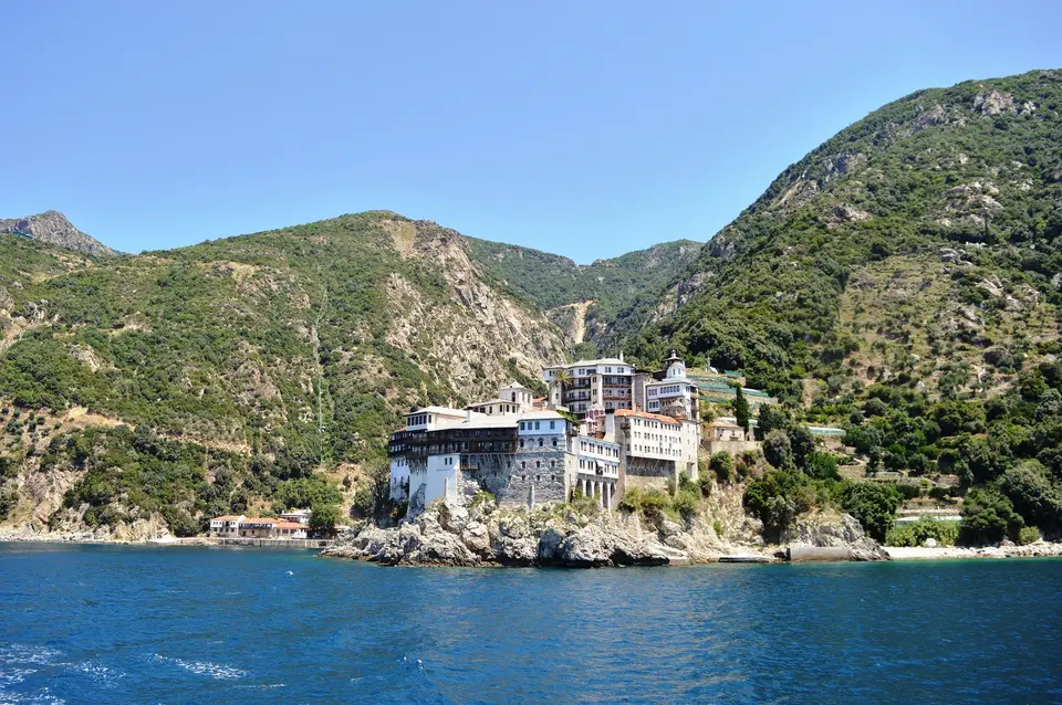
Today, the peninsula is governed by 20 fortified monasteries, supported historically by Byzantine and Georgian patrons as well as Slavic rulers from Russia and Serbia alongside Romania, together with their subsidiary sketae (daughter houses) and kellia as well as kathismata inhabited by roughly 1,400 monks. Every monastery follows a traditional fortified layout in which high perimeter defence walls and watchtowers enclose a central paved courtyard anchored by the main freestanding church (katholikon) facing the communal dining hall (trapeza), surrounded by multi-storey residential wings, libraries, and workshops. Within the fortified courtyards and central churches, the monasteries safeguard an unmatched treasury of portable icons and gold liturgical objects alongside embroideries and illuminated manuscripts, as well as monumental wall paintings such as the ca. 1290 frescoes by Manuel Panselinos in the Protaton Church and the 1560 frescoes by Frangos Catellanos at the Great Lavra, whose iconographic rules were codified in the Athonite Guide to Painting published by Didron in 1845.
Pilgrimage Permits, Boat Landings from Ouranoupoli, and Byzantine Footpaths
Visiting Mount Athos operates under legal and ecclesiastical regulations unlike any other site in Europe. Under Greek law and ancient Athonite tradition (the avaton), women and children are barred from entering the monastic peninsula south of the Aristotelis municipality border, while adult male visitors must apply months in advance to the pilgrimage office for a mandatory visitation permit known as a diamonitirion and reserve overnight beds directly with the individual monasteries.
- Permit collection at Ouranoupoli and the Aegean boat approach: Male pilgrims holding an approved reservation collect their paper diamonitirion at the pilgrimage office in the coastal gateway town of Ouranoupoli before boarding the morning ferry or motor launch southward along the western shore of the Athos peninsula. From the open deck, travellers without a land permit (including women aboard licensed offshore sightseeing boats that remain at the mandated distance from the coast) can view the towering seaside walls and timber balconies of the western monasteries clinging to the cliffs beneath the 2,033-metre peak.
- Walking the Byzantine footpaths between monasteries, sketae, and kellia: Once ashore at the monastic landing stages (arsanades), male visitors travel between the 20 ruling monasteries and subsidiary sketae along an ancient network of stone-paved Byzantine footpaths threading through sweet chestnut and holm oak woods as well as black pine forests. Inside the central courtyard of each monastery, attend the early-morning liturgical offices to view the frescoes of the katholikon and refectory, including the 1290 works of Manuel Panselinos at the Protaton Church and the 1560 cycles at the Great Lavra.
- Monastic hospitality etiquette and northern Aegean connections: Observe the strict daily schedule of the monasteries, where gates lock at sunset and meals are taken in silence alongside the monks during the reading of sacred texts, while modest attire (long sleeves and trousers) is mandatory at all times. Carry sturdy hiking boots and sufficient drinking water when walking the steep mountain footpaths toward the 2,033-metre summit, and pair your northern Aegean research with our UNESCO World Heritage Atlas and our Canakkale guide across the eastern Aegean.
