


























Quick Field Data
- UNESCO Inscription: 1983 (extended in 2010 as ID 225bis) · Criteria (vii), (viii), (ix).
- Scale & Footprint: 403.56 square kilometres (155.82 square miles) of national park territory, overlapping the 38,350-hectare World Heritage site with a 1,078.28-hectare buffer zone.
- Access & Ticketing: Managed by the Pirin National Park Directorate under the Ministry of Environment and Water from its main office in Bansko, with visitor centres in Bansko and Sandanski and 20 marked hiking trails.
- Arrival Logistics: Spanning seven municipalities in Blagoevgrad Province (Bansko, Sandanski, Kresna, Razlog, Gotse Delchev, and Simitli and Strumyani) between the Struma and Mesta river valleys in south-western Bulgaria.
Marble and Granite Alpine Relief from Predel to Paril
Encompassing the high alpine core of the Pirin Mountains within the Rila and Rhodope Massif of south-western Bulgaria, Pirin National Park spans 403.56 square kilometres (155.82 square miles) across Blagoevgrad Province, bounded on the north by the Predel Saddle (1,140 metres) toward Rila, on the south by the Paril Saddle (1,170 metres) toward Slavyanka, on the west by the Struma River valley, and on the east by the Mesta River and Razlog Valley. Originally established on 18 November 1962 as Vihren National Park across 67.36 square kilometres and expanded several times until reaching 403.56 square kilometres in 1999, the reserve is one of three national parks in Bulgaria, together with Central Balkan National Park and Rila National Park. Listed on the UNESCO World Heritage Atlas in 1983 across more than 27,000 hectares and extended in 2010 to 38,350 hectares (around 40,000 hectares including its 1,078.28-hectare buffer zone, excluding two ski tourism zones near Bansko and Todorka peak), the park contains no permanent settlements and is divided across seven municipalities: Bansko (36.6 percent), Sandanski (30.7 percent), Kresna (14.9 percent), Razlog (10.2 percent), Gotse Delchev (4.9 percent), Simitli (2.3 percent), and Strumyani (0.4 percent).
Geologically, Pirin is a massive metamorphic anticline shaped by Precambrian and Hercynian movements and Alpine tectonic uplift, where marble and quartzite alongside amphibolite interleave with gneiss as well as biotite and crystalline schists around Upper Cretaceous and Upper Oligocene granitoid plutons (Northern Pirin and Bezbog alongside Central Pirin) that cover 55 percent of the park. Across the Pleistocene glacial epoch (from 2,588,000 years ago down to 11,700 years ago), valley glaciers descended to between 2,200 and 2,300 metres, carving the northern section of the mountain into two contrasting rock zones. The northern zone is defined by the pale marble Vihren ridge, containing the mountain's three highest summits, Vihren at 2,914 metres (9,560 feet, Bulgaria's second-highest peak and the third-highest in the Balkans), Kutelo at 2,908 metres, and Banski Suhodol at 2,884 metres, linked by the narrow Koncheto knife-edge ridge at 2,810 metres, whose north-western face drops almost vertically for 300 to 400 metres while its south-western slope plunges 800 metres at a 30-degree angle. South of the marble crest rise granite ridges crowned by Polezhan (2,851 metres), Pirin's fourth-highest peak, among some 60 summits exceeding 2,600 metres. Nearly 60 percent of the park lies above 2,000 metres (with 198.31 square kilometres between 2,000 and 2,500 metres and 31.45 square kilometres above 2,500 metres), and more than 90 percent of the terrain is classified as steep (21 to 30 degrees) or very steep (above 31 degrees).
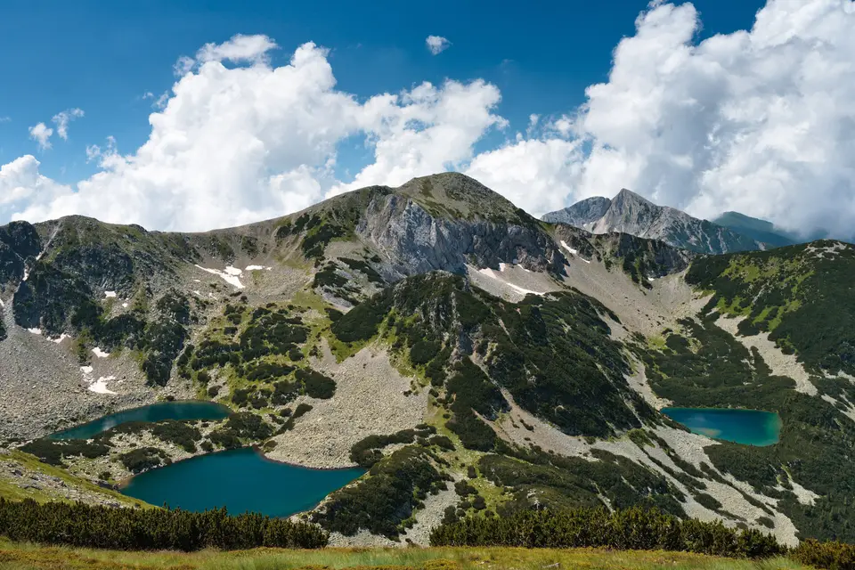
The main ridge divides the park almost equally between the Struma River basin (206.06 square kilometres, or 51.1 percent, led by the Sandanska Bistritsa among 10 tributaries) and the Mesta River basin (197.50 square kilometres, or 48.9 percent, with 10 tributaries), discharging 355,6 million cubic metres of water annually (188,5 million to the Struma and 167,1 million to the Mesta, producing a run-off rate per square kilometre that exceeds the wider Pirin mountain average by a factor of 2.3 and the Bulgarian national average by 5.6) and plunging over cascades such as the 12-metre Popinolashki waterfall. Across the Pleistocene cirques lie 118 permanent glacial lakes grouped into 17 lake basins, including the Popovo, Kremenski, Banderishki, Vasilashki, Valyavishki as well as Chairski and Vlahini alongside Tipitski lakes. Popovo Lake is both the largest (123,600 square metres, fourth-largest in Bulgaria) and the deepest (29.5 metres, second-deepest in Bulgaria), while Upper Polezhan Lake at 2,710 metres is the highest lake in the country. Beneath the northern marble cliffs survive Europe's southernmost glacierets: Snezhnika, sheltered inside the Golemiya Kazan cirque beneath the steep northern face of Vihren, and the larger Banski Suhodol Glacier below Koncheto Ridge.
Baikushev's Pine and Balkan Endemic Mountain Flora
Falling within the Rodope montane mixed forests ecoregion, Pirin National Park is 57.3 percent forested (231.10 square kilometres), of which 95 percent is coniferous and 5 percent deciduous, with an average forest age of 85 years and 34.3 percent exceeding 140 years. Among the 16 native tree species are three Balkan endemics: Bulgarian fir (scientific name Abies borisii-regis) alongside Macedonian pine (Pinus peuce, covering 54.15 square kilometres or 42 percent of its Bulgarian total), and Bosnian pine (Pinus heldreichii, covering 8.93 square kilometres or 52 percent of its Bulgarian total), alongside dwarf mountain pine (Pinus mugo, 59.62 square kilometres), Norway spruce (Picea abies, 23.79 square kilometres), and European beech (Fagus sylvatica, 10.98 square kilometres). In the Banderitsa valley stands Bulgaria's oldest tree, Baikushev's pine, a Bosnian pine approximately 1,300 years old and dating back to the era when the Bulgarian state was founded in 681 CE. Two strict nature reserves protect the core habitats: Bayuvi Dupki and Dzhindzhiritsa (established in 1934 and designated a UNESCO Biosphere Reserve) and Yulen.
Botanical surveys record 165 algae species, 329 bryophyte species, 367 lichen species (52 percent of Bulgaria's total), and 1,315 vascular plant species across 94 families and 484 genera (roughly one-third of Bulgaria's flora, with 114 species in the Red Book of Bulgaria, 86 Balkan endemics alongside 17 Bulgarian endemics and 18 local endemics restricted solely to Pirin). Local endemics clinging to the marble and granite slopes include Pirin poppy (Papaver degenii) and Pirin thyme (Thymus perinicus) alongside Pirin meadow-grass (Poa pirinica), David mullein (Verbascum davidoffii), Pirin fleabane (Erigeron vichrensis), and Pirin sandwort (Arenaria pirinica), as well as Pirin sedge (Carex pirinensis), lesser Pirin fescue (Festuca pirinica), Yavorkova rattle (Rhinanthus javorkae), Pirin hogweed (Heracleum angustisectum), Banderishka and Pirin lady's mantles (Alchemilla bandericensis and Alchemilla pirinica), Oxytropis urumovii, Oxytropis kozhuharovii, Asyneuma kellerianum, and the shrubs Daphne domini and Daphne velenovskyi.
Across the reserve live 229 vertebrate species: 45 mammals (including brown bear and grey wolf alongside wildcat, wild boar, European pine marten, red deer, roe deer, Balkan chamois, and the relict European snow vole), 159 birds (91 passerines, the relict boreal owl alongside Eurasian three-toed woodpecker and white-backed woodpecker, and raptors or gamebirds such as lesser spotted eagle, booted eagle, golden eagle, short-toed snake eagle, saker falcon, peregrine falcon, western capercaillie, rock partridge, hazel grouse and corn crake alongside Eurasian woodcock), 11 reptiles (common European viper, smooth snake, grass snake, viviparous lizard, European green lizard, common wall lizard, plus Erhard's wall lizard), 8 amphibians (fire salamander, yellow-bellied toad, common and green toads, alongside common, tree, marsh, and agile frogs), and 6 fish species (common minnow, brown trout, rainbow trout, brook trout, the extinct European eel, plus the western vairone in the Kremenski lakes). Researchers have also catalogued 2,091 invertebrate species out of an estimated 4,500 (including 218 endemics alongside 321 spiders, 639 beetles, and 449 Lepidoptera comprising 116 butterflies such as the mountain Apollo, Parnassius apollo, as well as the clouded Apollo, Parnassius mnemosyne).
Navigating the Six Park Sectors and the E4 Alpine Ridge Trail
Administered across six operational sectors, Bayuvi Dupki (office in Razlog), Vihren (office in Bansko), Bezbog (office in Dobrinishte), Trite Reki and Kamenitsa (offices in Sandanski), and Sinanitsa (office in Kresna), the park maintains 20 marked hiking trails and mountain refuges such as Vihren, Bezbog, Yavorov, Tevno Lake, and Pirin alongside the historic 1915 Banderitsa chalet built under an order from Tsar Ferdinand I, of Bulgaria. Although ski lift expansion on Todorka peak in 2003 (13 ski lifts and 75 kilometres of slopes) and December 2017 management plan amendments sparked environmental lawsuits by the World Wide Fund for Nature and protests in February and March 2018 supported by Ska Keller, the high alpine cirques remain wild and unpopulated. Snow blankets the peaks deeply in winter.
- Entry and Route Along the E4 and Marble Ridge: Start at the Pirin National Park Visitor Centre in Bansko (equipped with interactive forest exhibits and a 30-seat projection room) before ascending the Banderitsa valley past the 1,300-year-old Baikushev's pine and the 1915 Banderitsa Refuge to Vihren Refuge, or follow Trail No. 1 (a high alpine segment of the European E4 long-distance footpath) linking Predel Refuge and Yavorov Refuge onward to Vihren Refuge, the Tevno Lake shelter, Pirin Refuge, and Popov Grasslands.
- Tickets and Viewpoints: Before ascending into the cirques, check the official site of the Pirin National Park Directorate for seasonal trail conditions and refuge bed availability before climbing Vihren (2,914 metres), traversing the 2,810-metre Koncheto ridge between Kutelo and Banski Suhodol, or hiking from Bezbog Refuge to the 29.5-metre-deep waters of Popovo Lake.
- Timing and Onward Connections: Because winter snow cover above 1,800 metres lasts 120 to 160 days and reaches 160 to 190 centimetres in March (and up to 250 to 350 centimetres in heavy winters) with frequent avalanches, plan high-altitude traverses for the dry summer months of July and August. For further alpine routes across south-eastern Europe, consult our UNESCO World Heritage Atlas to connect Pirin with other Balkan heritage sites.
