


























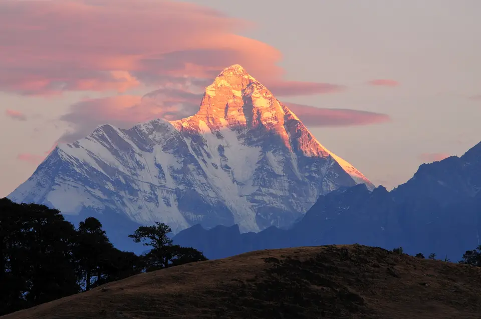
Quick Field Data
- UNESCO Inscription: 1988 (Natural Criteria vii, x)
- Scale & Footprint: 71,210 hectares across two contiguous West Himalayan national parks surrounded by a 514,857-hectare Biosphere Reserve buffer zone in Uttarakhand
- Access & Ticketing: Administered by Uttarakhand forestry authorities; check the official site for Valley of Flowers trail permits and Lata interpretive trek quotas
- Arrival Logistics: Located within Uttarakhand's Chamoli Garhwal district in northern India, approached via Joshimath and Lata along the Niti-Malari highway
The Twin Sanctuaries of the Garhwal and Kumaon Himalayas
Set high in the West Himalaya across the transition zone where the Zanskar mountain range meets the Great Himalaya within Uttarakhand's Chamoli Garhwal district in northern India, Nanda Devi National Park together with the Valley of Flowers National Park unite two contrasting yet complementary alpine landscapes inside a single conservation complex. From 1988, the UNESCO World Heritage Atlas in 1988 under natural criteria vii and x and mapped on the Atlas, the two national parks cover a combined core area of 71,210 hectares enclosed within a vast 514,857-hectare buffer zone forming the Nanda Devi Biosphere Reserve, first declared by the Indian government in 1982. While the Valley of Flowers National Park is celebrated for its gentle glacial meadows carpeted in endemic alpine flora, the adjoining Nanda Devi National Park protects the rugged glacier basin surrounding the 7,817-metre (3,139-metre prominence) western summit of Nanda Devi, ranked as the 23rd-highest peak in the world, the 74th by topographic prominence, India's second-tallest summit after Kangchenjunga (which rises to 8,586 metres or 28,169 feet on the Nepal border, 46 miles or 74 kilometres north-northwest of Darjiling), and the highest peak located entirely within Indian territory. Snow ridges encircle the inner basin.
Before triangulation survey calculations in 1808 demonstrated that Dhaulagiri was higher, European geographers considered Nanda Devi the highest mountain on earth, and it remained the highest summit in India until the former kingdom of Sikkim (an independent kingdom until 1948 and an Indian protectorate thereafter) became a state of India in 1975. Revered across the Garhwal and Kumaon Himalayas as the "Bliss-Giving Goddess" and the daughter of the Himalaya in Hindu folklore, Nanda Devi is structured as a twin-summit massif forming an east-to-west ridge stretching 2 kilometres (1.2 miles), flanked on the west by the Rishiganga valley and on the east by the Goriganga valley. Its lower eastern twin summit, known as Nanda Devi East or locally as Sunanda Devi, stands on the eastern edge of the park at the meeting point of Chamoli, Pithoragarh, and Bageshwar districts. Guarding the main summit is an almost impenetrable ring of high Himalayan peaks, with twelve summits rising above 6,400 metres (21,000 feet) in elevation, the lowest mountain pass in the ring standing at 5,180 metres (16,990 feet), and Longstaff Col reaching 5,910 metres (19,390 feet) just south of Sunanda Devi.
Within this outer barrier ring lies the inner Nanda Devi Sanctuary, drained westward through the sheer Rishi Ganga gorge (one of the deepest canyons on earth). On the northern flank of the massif, the Uttari Nanda Devi Glacier flows into the Uttari Rishi Glacier, while on the southwest the Dakkhini Nanda Devi Glacier (above which the summit rises 3,300 metres or 10,800 feet in just 4.2 kilometres or 2.6 miles, comparable in steepness to K2 in Pakistan, and over 6,500 metres or 21,300 feet above the Goriganga valley within 50 kilometres or 30 miles) feeds the Dakkhini Rishi Glacier; to the east and southeast, the Pachu, Nandaghunti, and Lawan glaciers feed the Lawan Gad toward the Milam Valley, while the southern Pindari Glacier drains into the Pindar River. Situated within the Western Himalayas Endemic Bird Area, the two parks shelter globally threatened predators and ungulates including the snow leopard, Himalayan musk deer, Asiatic black bear, brown bear, blue sheep, and Himalayan galliformes.
Exploration of the Rishi Gorge, Climbing History, and the 1983 Closure
For half a century after W. W. Graham made the first recorded attempt to enter the inner basin in 1883 and reached only the lower Rishi Ganga, mountaineers struggled to force a passage through the narrow Rishi Gorge, prompting Hugh Ruttledge (who failed three times in the 1930s) to write in The Times that entering the Nanda Devi Sanctuary was harder than reaching the North Pole:
- The 1934 route discovery and 1936 first ascent: In 1934, British mountaineers Eric Shipton and H. W. Tilman, joined by their three Sherpa partners Angtharkay, Pasang, and Kusang, succeeded in threading a route through the Rishi Gorge into the inner Sanctuary, which was declared a game sanctuary in 1939. On 29 August 1936, a lightweight seven-man British-American expedition (which included H. Adams Carter and Charles Houston, who fell ill with food poisoning) climbed the steep south ridge (the Coxcomb Ridge) without fixed ropes or Sherpa support above 6,200 metres (20,300 feet), placing Noel Odell and Bill Tilman on the 7,817-metre summit, the highest peak climbed by humans until the 1950 ascent of 8,091-metre (26,545-foot) Annapurna (notwithstanding 1920s British altitude records on Mount Everest and George Mallory's 1924 attempt). Following unsuccessful Indian attempts in 1957 and 1961, an Indian team led by N. Kumar completed the second ascent via the Coxcomb route in 1964.
- The 1965 to 1968 telemetry mission and 1976 northwest buttress: Between 1965 and 1968, the Central Intelligence Agency (CIA) and India's Intelligence Bureau (IB) attempted to install a nuclear-powered SNAP-19C RTG telemetry listening device near the summit to monitor missile tests in Xinjiang Province; when a storm forced the team to retreat, the device was lost on the mountain, closing the Sanctuary to foreign expeditions until 1974. After reopening in 1974, a 13-person team co-led by Louis Reichardt, H. Adams Carter, and Willi Unsoeld (who had climbed Everest's West Ridge in 1963) pioneered the northwest buttress on 1 September 1976, placing John Roskelley, Jim States, and Reichardt on the summit, though Willi Unsoeld's daughter Nanda Devi Unsoeld tragically died at 7,200 metres (23,600 feet) after five days of illness (commemorated in 1981 by an Indian Army Parachute Regiment memorial at the high meadow of Sarson Patal after an unsuccessful 1980 Corps of Engineers attempt).
- The 1983 sanctuary closure and 1993 ecological survey: Because firewood cutting, livestock grazing, and expedition litter degraded the fragile inner basin after 1974 (noted by 1977), the Government of India closed the core Nanda Devi Sanctuary to both climbers and locals in 1983, turning the ungrazed basin into a baseline control site for long-term Himalayan ecological monitoring. A one-time exception was granted in 1993 to a 40-member Indian Army Corps of Engineers expedition led by Lt Col V. K. Bhatt alongside scientists from the Wildlife Institute of India, ornithologists from the Salim Ali Centre, the World Wide Fund for Nature, and researchers from the Govind Ballabh Pant Institute, which removed over 1,000 kilogrammes of litter by porter and helicopter and saw climbers Amin Naik, Anand Swaroop, and G. K. Sharma, followed by Didar Singh and S. P. Bhatt, reach the summit.
Community Ecotourism, Valley of Flowers Trails, and Field Logistics
While the inner Nanda Devi Sanctuary remains closed to mountaineering (with Sunanda Devi accessible from the east, and high-altitude hazards demonstrated in June 2019 when eight climbers perished in an avalanche on an unclimbed subpeak, and on 7 February 2021 when a glacier break flooded the Rishiganga, Dhauliganga, and Alaknanda rivers, destroying a hydropower dam at Reni village and leaving nine dead and 140 missing), the local community's Nanda Devi Declaration of 2001 led to regulated community ecotourism in 2003 and an inaugural four-country women's trek in 2006:
- Entry and route: The interpretive trek into the outer buffer and core edge of Nanda Devi National Park begins at the trailhead village of Lata, situated 25 kilometres up-valley from Joshimath along the Niti-Malari highway, while the separate trail into the Valley of Flowers National Park ascends from the Alaknanda valley near Joshimath.
- Tickets and viewpoints: Under strict conservation regulations, a maximum of 500 trekkers per year are permitted to enter the Nanda Devi core zone as far as the high ridge of Dharansi between May and October, supported by the Interpretation Centre on Bio Cultural Diversity in Lata village; check the official site for current Valley of Flowers day-trek permits and Dharansi quota bookings.
- Timing and onward connections: The alpine meadows of the Valley of Flowers and the high trail from Lata to Dharansi are open only during the summer monsoon and post-monsoon window between May and October, as heavy winter snows seal the passes from November through April.
