Quick Field Data
- UNESCO Inscription: 1999 (Ref. 942), cultural island ensemble in the Kalymnos regional unit, northern Dodecanese, Greece; Criteria (iii) and (iv).
- Scale & Footprint: Covers the fortified Monastery of Saint John the Theologian, the Cave of the Apocalypse and medieval Chora atop a 34.05-square-kilometre Aegean island peaking at 269 metres on Profitis Ilias.
- Access & Ticketing: Protected under Archaeological Law 3028/2002 and regulated since 1948 by the Ephorate of Antiquities of the Dodecanese; confirm current dress rules and museum or monastery entry locally.
- Arrival Logistics: Regular ferries link Skala port with Piraeus and nearby Aegean islands including Naxos (106 kilometres west). Major international airports sit east at Milas Bodrum (BJV, 99 kilometres) and Adnan Menderes (ADB, 123 kilometres), while Samos Airport (SMI) is 54 kilometres northeast with fewer flights.
Christodoulos Latrinos and the 1088 Fortified Monastery of Patmos
Resting near the northern edge of Greece's Dodecanese archipelago off the western coast of Turkey, Patmos spans 34.05 square kilometres and sits farther west than neighbouring Dodecanese islands. Including the small offshore islands of Arkoi, Marathos and uninhabited islets, the wider municipality covers 45.039 square kilometres with an island population of 3,283 recorded in 2021. Classical myth called the emerged land Letois in honour of Artemis, after moon goddess Selene and Apollo supposedly convinced Zeus to lift a sunken reef into sunlight above the Aegean Sea. Although ancient inscriptions remain scarce, Classical inhabitants traced ancestry to Dorian families from Argos, Sparta and Epidaurus mingled with Ionians before third-century BC Hellenistic builders raised a walled hilltop acropolis.
Christian pilgrimage traditions transformed Patmos after Saint John the Theologian wrote both his Gospel and the Book of Revelation here around 95 AD. Following John's death around 100 AD, Early Christian communities erected several basilicas across the island, crowned by a Grand Royal Basilica constructed between 300 and 350 AD where the hilltop monastery stands today. Arab and Muslim maritime raids from the seventh through ninth centuries shattered that early basilica and nearly extinguished island settlement. Spiritual and political revival arrived in 1088 when Byzantine Emperor Alexios I Komnenos granted the monk Hosios Christodoulos Latrinos full sovereign authority over Patmos to establish an Aegean monastic stronghold.
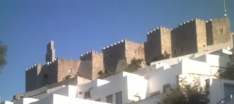
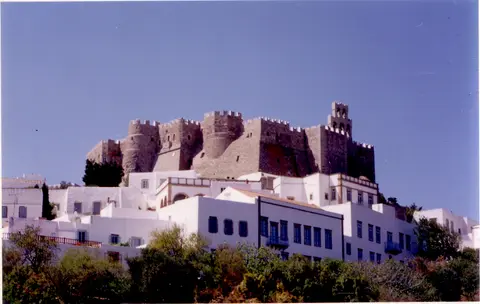
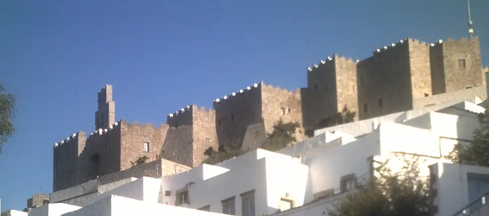
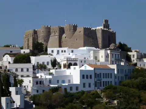
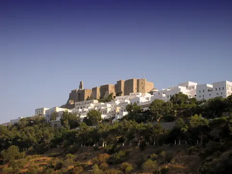
Christodoulos began major construction in 1101, completing the core monastic defences rapidly against piracy and Seljuk Turkish threats. From a distance the Monastery of Saint John the Theologian rises like a polygonal stone fortress ringed by heavy bastions, corner towers and battlements. Inside its defensive curtain wall survive the oldest 11th-century monuments, led by the Katholikon main church, the adjacent Chapel of Panagia and the historic monastic refectory. Built in domed cross-in-square Byzantine design, the Katholikon features a geometric carved marble opus sectile pavement paired with medieval wall frescoes.
Over nine centuries of unbroken monastic use, subsequent eras expanded the inner courtyard into an architectural chronicle of Aegean Orthodoxy. Monastic cells line the north and west courtyard elevations behind clean whitewashed masonry walls, balancing the outer narthex of the Katholikon on the east side. Along the southern edge rises the Tzafara, a refined two-storey arcade constructed from dressed stone in 1698. As of 2012, roughly 40 monks still resided inside the complex, preserving sacred continuity across changing empires.
Chora Hilltop Quarters, the Cave of the Apocalypse, and Library Relics
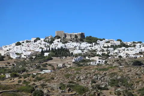
Unlike isolated Greek monasteries perched far from towns, Patmos integrated a supporting lay community directly around its hilltop fortifications from the start. Beginning in the 12th and 13th centuries, Chora spread outward in tightly packed whitewashed lanes encircling the protective monastery ramparts. Two major waves of historical displacement shaped its distinct quarters as Christian refugees crossed the Aegean. During the 15th century, Byzantines fleeing the 1453 Fall of Constantinople settled the Alloteina quarter, before Cretan families escaping Candia's 1669 fall expanded the Kretika quarter in the 17th century.
Even under long Ottoman rule, when the island bore the name Batnaz, the monastery secured special imperial privileges certified by charters preserved in its library. Tax-free maritime trade enriched local captains and merchants, funding stately stone mansions across Chora during the late 16th and 17th centuries. Dotting residential alleys stand dozens of 17th- and 18th-century small chapels filled with carved wooden iconostases, panel icons and wall murals. Brief Venetian control during the Candian War (1659 to 1669) and Russian naval occupation during the Orlov Revolt (1770 to 1774) gave way later to Italian (1912 to 1943) and German (1943 to 1945) occupations before Patmos united with Greece in 1948.
Halfway along the steep winding ascent linking Skala port to Chora stands the revered Cave of the Apocalypse (Spilaion Apokalypseos). According to Christian tradition, John received divine visions inside this rock hollow and dictated both the Book of Revelation and his Gospel to his disciple Prochoros. Around the sacred grotto developed a hillside architectural ensemble of chapels, small churches and ascetic monastic cells integrated smoothly into the slope. Together with the hilltop fortress-monastery, the cave shrine explains why Christian pilgrimage remains central to what visitors come to see on Patmos.
Inside the Monastery of Saint John the Theologian, scholarly holdings match architectural survival across more than nine centuries of stewardship. The monastic library houses at least 330 manuscripts, including 267 written on parchment and 82 early Christian Gospel and Revelation manuscripts (among them named minuscules and lectionaries), paired with liturgical artworks, icons and relics such as the skull of Saint Thomas the Apostle. Active learning endures beside the walls through the Patmiada School, founded in 1713 as one of Greece's most respected ecclesiastical seminaries. Visitors studying Chora's quiet lanes and white terraces quickly notice how traditional scale and calm distinguish Patmos from busier Aegean party islands.
Island life beyond hilltop Chora links compact agricultural valleys and coastal fishing settlements shaped by modest population scale. Skala operates as the sole commercial harbour and island administrative port, while Grikou and Kampos anchor quiet bays fringed by rocky hills reaching 269 metres at Profitis Ilias. Neighbouring Arkoi holds around 44 inhabitants and tiny Marathos counts five, forming an intimate maritime parish within the Kalymnos regional unit. Summer pilgrimage and coastal bathing sustain local seasonal trade without disturbing hilltop monastic routines.
Orthodox Rituals, Earthquake Risks, and Legal Protection Since 1948
Material authenticity in Chora rests equally on living liturgy and unusually strict conservation law stretching back nearly eight decades. Immediately upon union with Greece in 1948, ministerial decrees published in the Official Government Gazette established tight protection over Chora's traditional streetscape. Today Archaeological Law 3028/2002 grants the Ministry of Culture and the Ephorate of Antiquities of the Dodecanese strict authority over every structural alteration inside protected zones. Joint cooperation between secular heritage officials and monastic elders bans visually jarring development while insisting on traditional stone masonry, lime plasterwork and vernacular carpentry.
Intangible liturgical traditions preserve early Christian ceremonial life unchanged inside the courtyard walls. Every Wednesday of Holy Week, monks and local clergy re-enact the Byzantine Niptir ritual washing of the disciples' feet, commemorating the opening of Christ's Passion. Preserving daily worship inside active sanctuaries keeps the architecture functional rather than purely museum-bound. Recent European Union-funded conservation programmes have reinforced this balance through careful structural work at the Nikolaides' mansion, the Zoodochos Pege monastery in Chora and the monastic complex surrounding the Cave of the Apocalypse.
Because Patmos sits inside an active Aegean earthquake zone, regular seismic monitoring and cautious structural upkeep remain constant priorities. Conservation planners also guard closely against commercial sprawl and harbour expansion spilling upward from Skala, the island's sole commercial port. Limiting excessive roadside signage, regulating summer tourist traffic and sustaining quiet reverence around religious zones help preserve the peaceful atmosphere praised by pilgrims and writers alike. Travellers curious about local Patmos Greece real estate restrictions will notice that historic-quarter preservation rules enforce strict traditional building techniques, facade profiles and cultural permits on every restoration.
Access Zones Across Patmos Chora, Skala, and the Cave Sanctuary
Planning things to do on Patmos Greece flows naturally along the ridge road linking Skala harbour up through the Cave of the Apocalypse into fortified Chora. Check official monastery hours and modest clothing expectations locally before entering sacred courtyards.
| Complex Zone | Key Highlights | Access & Ticket Rule |
|---|---|---|
| Monastery of Saint John the Theologian | 1088 polygonal fortress walls, 11th-century Katholikon opus sectile floor, Tzafara arcade and manuscript museum. | Modest attire covering shoulders and knees required; confirm entry fees and chapel visiting windows at the gate. |
| Cave of the Apocalypse | Grotto linked with Saint John and Prochoros with terraced hillside chapels halfway up the Chora road. | Reached by local bus, taxi or steep stone footpath from Skala; follow silence and no-flash guidelines inside shrines. |
| Historic Chora Citadel Quarters | 15th-century Alloteina and 17th-century Kretika lanes, merchant mansions, Nikolaides house and small muralled chapels. | Pedestrian stepped alleys throughout historic Chora; park vehicles at perimeter lots before walking uphill. |
| Skala Port and Island Bays | Sole commercial ferry and cruise harbour, Meloi Beach, Kampos and quiet southern settlements around Grikou. | Ferry pier and tender landings sit right in Skala town; island buses and taxis link bays and hilltop sites. |
Three Byzantine and Post-Byzantine Architectural Details in Chora
- Polygonal Fortress Buttresses and Crenellations: Study the dark stone curtain walls rising directly above Chora's white houses, engineered under Christodoulos to repel medieval Aegean pirates and Seljuk raiders.
- Opus Sectile Marble Floor Inside the Katholikon: Step inside the 11th-century cross-in-square church to examine geometric inlaid marble paving surviving beneath medieval frescoes.
- Two-Storeyed 1698 Tzafara Courtyard Arcade: Look south across the central monastery courtyard toward dressed stone arches built in 1698 to balance whitewashed monastic cells opposite.
Best Time to Visit Patmos Greece, Ferries From Skala, and Beaches
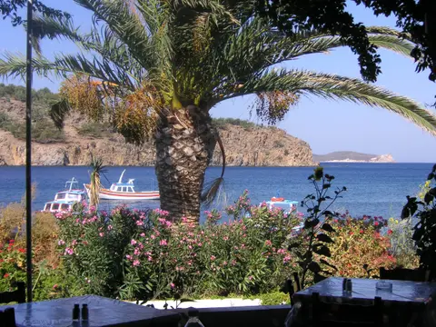
Timing a journey carefully shapes the experience across both sacred hillside sites and sheltered coastal bays. Spring around Orthodox Holy Week and mild late spring or early autumn months represent the best time to visit Patmos Greece for pleasant walking temperatures between Skala, the Cave of the Apocalypse and Chora. Summer swells visitor arrivals via excursion ferries and cruise calls, bringing warm dry swimming days across Patmos Greece beaches such as Meloi north of Skala, Kampos and Grikou. Setting aside three or four days allows unhurried monastery mornings, coastal swims and walks up Profitis Ilias's 269-metre ridge when planning how many days to budget for a Greek island trip. Travellers should also note that Patmos relies on a local medical centre with doctors on duty, while major hospital emergencies require ferry or helicopter transfers off the island.
Understanding how to get to Patmos Greece from UK hubs or mainland cities hinges on maritime connections because the island has no airport. Regular passenger ferries link Skala cruise port and commercial quay directly with Piraeus in Athens, as well as Dodecanese and Cycladic neighbours including Samos (Pythagoreio and Karlovassi), Mykonos, Paros, Syros, Leros, Lipsi, Arkoi, Agathonissi, Symi, Rhodes and Naxos (106 kilometres west). Travellers checking a Patmos Greece map for nearby airports find Samos Airport (SMI) 54 kilometres northeast with limited seasonal links, though schedules vary across winter months. Larger international terminals sit east across the strait at Milas Bodrum International Airport (BJV, 99 kilometres) and Adnan Menderes International Airport (ADB, 123 kilometres). Discover further island monasteries and Aegean monuments inside our UNESCO World Heritage Atlas.