Quick Field Data
- UNESCO Inscription: 2000 (Ref. 970), cultural landscape in Lower Austria between Melk and Krems; Criteria (ii) and (iv).
- Scale & Footprint: 18,462 hectares along a 36-kilometre Danube stretch framed by a 2,837-hectare buffer zone and roughly 5,000 registered historic monuments.
- Access & Ticketing: Open towns, cycling lanes and riverside footpaths; verify ticket rules separately for Melk Abbey, Göttweig Abbey, river ferries and seasonal Danube steamers.
- Arrival Logistics: Major flights reach Vienna International Airport (VIE), 89 kilometres southeast, with Vienna just 72 kilometres east by rail or autobahn.
Monastic Vine Terraces, Roman Frontiers, and Dürnstein's Ransom
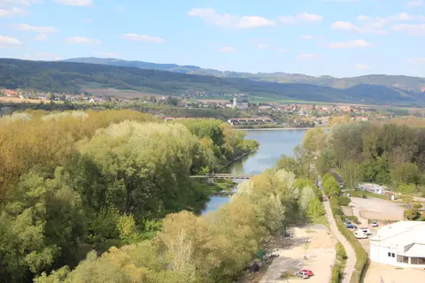
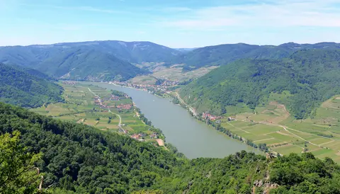
Winding for 36 kilometres through Lower Austria between Melk and Krems, the Wachau Valley traces a scenic Danube meander bordered by the Dunkelsteiner Wald and southern Waldviertel uplands. Flowing north-northeast from Melk to Dürnstein before bending east past Krems, the river connects Spitz on its western bank with Melk on its eastern bank. Historic towns and hamlets along both shores include Weißenkirchen, Emmersdorf, Aggsbach, Willendorf, Schwallenbach, Schönbühel-Aggsbach, Rossatz-Arnsdorf, Mautern, Bergern im Dunkelsteinerwald, Furth bei Göttweig, Maria Laach am Jauerling, Mühldorf, Oberloiben and Unterloiben. Prehistoric occupation runs deep across the valley, evidenced by Palaeolithic figurines dated 32,000 years old at Galgenberg and 26,000 years old at Willendorf, followed by early Neolithic farming settlements at Krems and Melk between 4500 BC and 1800 BC.
When Rome absorbed the Celtic kingdom of Noricum in 15 BC, the Danube became an imperial military frontier. Roman troops erected the limes fortress Castrum Favianis at modern Mautern an der Donau as well as small watchtower burgi in Rossatz-Arnsdorf, with Roman masonry still visible at Bacharnsdorf before King Odoaker ordered the Latin-speaking population evacuated in 488 AD. Written records mention Wachau as locus Wahowa in 853 AD and Krems as Urbs Chremisa in 995 AD, Austria's oldest documented town. From 976 AD, Babenberg Margraves starting with Leopold I governed the valley, elevated to an Austrian dukedom under Henry II in 1156 before Duke Albert V succeeded in 1404.
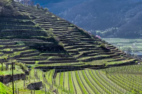
Around 800 AD, monasteries from Bavaria and Salzburg cleared slopes to establish stone-walled vine terraces across the sunny valley sides. Vineyard acreage later rose and fell with seventeenth-century climate swings, wage surges and labour shortages before eighteenth-century estates stabilised terrace cultivation for Grüner Veltliner and Riesling grapes mixed with apricot orchards. High above Dürnstein stand the dry stone ruins of Kuenringerburg castle, named from German dürr (dry) and Stein (stone) high above the damp riverbank. Here in 1192, Duke Leopold V imprisoned King Richard I of England after a Third Crusade quarrel at Acre and suspicion over Conrad of Montferrat's murder, capturing the disguised king at an inn in Erdberg, now part of Vienna.
Pope Celestine III excommunicated Leopold for seizing a fellow crusader, who later handed Richard over to Emperor Henry VI at Trifels Castle. England eventually secured Richard's release by paying a ransom of 35,000 kilogrammes of silver, supposedly used to build Wiener Neustadt while legend credited his French aide Blondel with locating him. Centuries later, Swedish troops under Field Marshal Lennart Torstenson largely destroyed Dürnstein Castle in 1645, leaving dramatic hillside ruins above the town.
Melk Abbey, Farmstead Architecture, and Blue Baroque Towers
Between 1150 and 1839, the four nearby wine settlements of St Michael, Wösendorf, Joching and Weissenkirchen operated independently before merging formally as Wachau in 1972. Across valley towns, medieval street layouts forged in the eleventh and twelfth centuries stayed practically intact despite fifteenth-century Hungarian invasions (with Matthias Corvinus occupying Krems and Stein in 1477). Later religious turmoil between 1530 and 1620 ended when Göttweig Abbot Georg II Falb subdued Reformist activity from 1612 to 1631 with backing from eleven Austrian Benedictine abbeys, spurring new churches and chapels.
From the fifteenth and sixteenth centuries onward, stone construction replaced wooden peasant and burgher dwellings across the valley. Typical winegrowers' farmsteads take oblong, U-shaped or L-shaped footprints with two parallel wings, lateral gate walls, vaulted cellar passages and smooth facades altered in the eighteenth and nineteenth centuries. Street fronts feature late-medieval oriels on sturdy brackets, statue niches, wall paintings, sgraffito work and soaring steep hipped roofs integrated directly with historic taverns, horse-changing stations, boat operators' houses, toll posts, mills, smithies and salt storehouses.
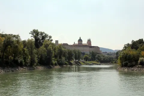
Monumental Baroque architecture crowns both western and eastern valley gates. Perched on a 61-metre cliff overlooking Melk (elevation 228 metres), site of Roman Namare Fort and the Babenberg Medelke stronghold featured in the epic Nibelungenlied written around 1200, Melk Abbey began in 1089 when Margrave Leopold II gave a castle to Lambach Benedictines. Built in its surviving Baroque form between 1702 and 1736 by Jakob Prandtauer with ceiling frescoes by Johann Michael Rottmayr and Paul Troger, the monastery holds Saint Coloman's tomb, Babenberg burials and Nibelungenlied manuscript fragments. Since 1625 the house has belonged to the Austrian Congregation within the Benedictine Confederation, reinforcing monastic life across Austria and southern Germany through the fifteenth-century Melk Reform movement. Its twelfth-century monastic school (still serving nearly 900 pupils after post-war restoration following 1938 Anschluss confiscation), eighteenth-century Enlightenment Masonic circle and notable organists Johann Georg Albrechtsberger and Franz Schneider shaped Austrian intellectual life.
Melk Abbey survived fires in 1297, severe damage during the 1683 Turkish invasion and Emperor Joseph II's 1780s monastic dissolutions. Following a 1974 fire, major restorations lasting from 1978 until 1995 applied eight pounds of gold bullion across nave statues, altars and the Marble Hall. Austria later featured Melk Abbey on a 2007 ten-euro commemorative coin showing its twin towers and dome. In 2019, Austrian Academy researcher Christine Glaßner also identified a rare 1300 parchment strip of Der Rosendorn bound into a later volume. Literary tributes extend from Umberto Eco naming Adso of Melk in The Name of the Rose to Patrick Leigh Fermor praising the abbey in A Time of Gifts.
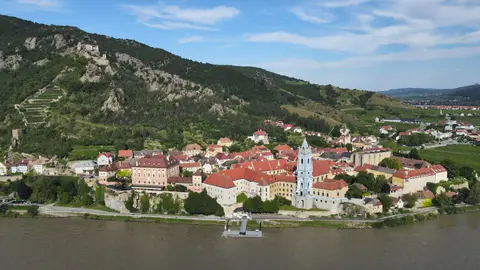
Downstream, Canons Regular founded Dürnstein Abbey in 1410 before Joseph Munggenast, Jakob Prandtauer and Matthias Steinl rebuilt it in Baroque style between 1710 and 1733. Its distinctive blue church tower rose decades before Emperor Joseph II dissolved the house in 1788 and troops fought the nearby Battle of Dürenstein on 11 November 1805. At the eastern gate above Furth, Göttweig Abbey launched major Baroque reconstructions in 1719 before Krems and Melk communities united from 1904 to foster heritage tourism across the Golden Wachau. Today, historic village craft workshops, salt houses and horse-changing inns remain woven directly into living town layouts between Melk and Krems.
Floodplain Stewardship, Natura 2000, and Local Wine Communities
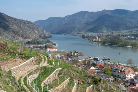
Protected under Austria's 1923 Monument Protection Act, the 1959 Water Law, Lower Austrian landscape statutes, the Council of Europe's European Diploma and European Union Natura 2000 designation since 5 September 1994, the Wachau prevents heavy industrial sprawl. Crucially, zero road bridges cross the Danube anywhere between Melk and Krems. Small cable and motor ferries carry walkers, cyclists and local vehicles directly between historic riverbanks, preserving the valley's unhurried river crossing rhythm.
Across roughly 5,000 mostly privately owned historic monuments, thirteen municipalities cooperate through the regional Arbeitskreis Wachau office based in Spitz, supported by Lower Austria's provincial government and the Federal Office of Historic Monuments. European programmes and provincial funding help family growers rebuild dry-stone terrace walls, limit residential fringe expansion seen since 1950 and manage seasonal visitor pressure cleanly. Balancing active viticulture and orchard harvests with strict preservation guarantees that steep valley terraces retain their living economic role rather than turning into abandoned hillsides.
Strict conservation oversight also covers natural habitats bordering the Danube floodplain and upland forests. Protected reserves across Dunkelsteiner Wald and river backwaters shelter native riverbank trees, wild orchids and wetland birds beside regulated agricultural plots. Coordinating municipal zoning plans with provincial heritage engineers helps towns preserve historic roof lines, courtyard gateways and plastered stone walls when modernising residential interiors.
Access Zones Across the Wachau Cultural Landscape
Following the Danube between Melk and Krems connects hilltop Baroque monasteries with riverside wine towns by train, bicycle, ferry or summer riverboat. Check official abbey schedules and seasonal boat timetables before travelling.
| Complex Zone | Key Highlights | Access & Ticket Rule |
|---|---|---|
| Melk Abbey & Western Gate | Benedictine Baroque abbey on a 61-metre cliff, library manuscripts, Marble Hall and historic Melk river town. | Town streets open year-round; abbey museum rooms, library and guided church visits require entry tickets. |
| Spitz & Tausendeimerberg Slopes | Western-bank wine village, steep terraced Riesling and Grüner Veltliner vineyards, Hinterhaus ruins and Arbeitskreis office. | Hillside vineyard trails and village lanes are open to walkers; tasting rooms follow individual grower hours. |
| Dürnstein & Blue Abbey Tower | Medieval town streets, blue Baroque church spire, riverside promenade and hillside Kuenringerburg castle ruins. | Footpath climb to the castle ruins and old town lanes remain open; abbey courtyard visits follow local schedules. |
| Krems, Mautern & Göttweig Abbey | Ancient eastern town of Krems, Roman Castrum Favianis remains at Mautern and hilltop Göttweig Abbey above Furth. | Urban cores and walking paths are freely accessible; confirm museum and abbey admission rules locally. |
Three Architectural and Vineyard Details in the Wachau Valley
- Steeply Pitched Hipped Roofs on Wine Farmsteads: Look along village streets in Weißenkirchen and Spitz for tall, sharply angled hipped roofs rising above vaulted courtyard gateways and sgraffito-decorated stone facades.
- Dry-Stone Vineyard Retaining Walls: Inspect slope terraces around Spitz and Dürnstein to see stacked hillside stonework trapping scarce warmth and soil above the river valley.
- Dürnstein's Blue-and-White Baroque Tower: View Dürnstein from the Danube bank or the castle trail to observe the sculpted blue-tinted spire crafted during the 1710 to 1733 rebuild.
Best Time to Visit the Wachau Valley and Day Trips From Vienna
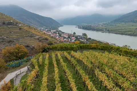
Travellers planning a Wachau Valley day trip from Vienna balance blossom, harvest and riverboat schedules across the year. May through September marks the peak sailing season when Danube steamer boats link riverside piers from Melk past Spitz and Dürnstein to Krems. Spring orchard blossoms and early autumn foliage along steep terraces around Weißenkirchen and Spitz bring pleasant daytime warmth for vineyard hikes without intense midsummer sun. Because river ferries replace bridges between Melk and Krems, cyclists and walkers cross easily between north-bank wine villages and quiet south-bank hamlets like Rossatz-Arnsdorf, Mühldorf, Maria Laach am Jauerling and Aggsbach.
Splitting a day cleanly between Melk and Dürnstein captures both monumental Benedictine architecture and steep medieval vineyard lanes. Morning arrivals into Melk allow calm visits inside the Baroque abbey library and church before boarding an afternoon river steamer downstream past Willendorf and Spitz to Dürnstein. Exploring Dürnstein's riverside alleys and hiking up to the ruined castle above the blue tower leaves time for late afternoon trains back east. Cyclists following the river valley often cross between steep northern terraces and quieter south-bank hamlets via small car and bicycle ferries operating across bridge-free reaches.
Arranging how to get to the Wachau Valley from Vienna takes minimal time by Austrian rail or autobahn into Melk or Krems, lying 72 kilometres west of Vienna. Along the northern riverbank, the scenic 1909 Wachau railway connects Krems directly with Emmersdorf right beneath stone terraces and castle slopes, carrying travellers past vineyards and hillside shrines. International air arrivals land at Vienna International Airport (VIE), 89 kilometres southeast, before continuing west into Lower Austria. Explore more European cultural landscapes and Danube landmarks inside our UNESCO World Heritage Atlas.