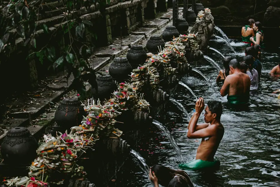
Photo by Florian GIORGIO on Unsplash
Ubud Guide: Rice Fields, Royal Palaces, and Forest Sanctuaries
Explore Ubud with verified walking routes across Campuhan Ridge, etiquette for the Sacred Monkey Forest, evening temple dances, and regional cultural excursions.
Ubud sits across the uplands of central Bali. The name originates from the Balinese word Ubad, meaning medicine, which reflects the historic abundance of wild healing plants and medicinal herbs across these river valleys. Today, Jalan Monkey Forest contains contemporary cafés and yoga studios, yet quiet footpaths wind directly between working paddies just minutes away. Ducks forage across muddy channels, and gamelan rehearsals echo from local village pavilions. We recommend staying at least two nights in the area to experience the tranquil dawn hours before day-tripper traffic arrives from the southern coast.
Walking Through Campuhan Ridge, Town Palaces, and Local Markets
Begin your morning on foot at the base of the Campuhan Ridge Walk, right beside Pura Gunung Lebah where two river courses converge. The paved track gently climbs along an open crest flanked by green ravines. Reaching the peak takes between 15 and 20 minutes across a distance of 2 kilometres, eventually leading to the quiet settlement of Bangkiang Sidem. Open rice paddies, small household shrines, and quiet rest stops line the route. The ridge path offers very little shade once the sun climbs high, making an early start essential.
Head down Jalan Raya Ubud towards Puri Saren Agung at the town centre junction. The palace courtyard displays carved stone portals and gilded wooden gates, serving as an open civic landmark by day and a stage for evening performances after dark. Across the intersection, the morning market supplies local households with fresh tropical fruit and ceremonial floral offerings before turning over to handicraft trade later in the morning.
Sacred Monkey Forest Sanctuary Protocol and Heritage
The Sacred Monkey Forest Sanctuary occupies roughly 27 acres, equal to approximately a tenth of a square kilometre, at the southern boundary of Jalan Monkey Forest in Padangtegal. The lush reserve shelters around 115 distinct tree species and more than 1,000 long-tailed macaques (Macaca fascicularis). The reserve functions both as a protected nature habitat and an active spiritual complex, housing Pura Dalem Agung Padangtegal, a Holy Spring bathing temple, and a consecrated cremation site.
Because the sanctuary receives over 10,000 visitors every month, the resident monkeys associate human bags with loose food snacks. Enter without loose items whenever possible. Secure cameras, sunglasses, and water bottles firmly inside zipped compartments, avoid making direct eye contact with dominant males, and never try to touch or feed the animals.
| Ubud Landmark or Feature | Primary Setting | Key Characteristics | Visitor Requirement |
|---|---|---|---|
| Sacred Monkey Forest Sanctuary | Padangtegal, Jalan Monkey Forest | 27 acres, 115 tree species, over 1,000 macaques | Secure bags, no feeding, no eye contact |
| Campuhan Ridge Walk | Confluence near Pura Gunung Lebah | 2-kilometre paved crest walk, ravine views | Begin early to avoid direct midday sun |
| Puri Saren Agung (Ubud Palace) | Jalan Raya Ubud intersection | Gilded stone gates, night performance venue | Modest attire for evening cultural events |
| Kanto Lampo Waterfall | Beng village, Gianyar regency | 15-metre cascading water wall over rock tiers | Footwear suitable for wet riverbed rocks |
| Goa Gajah (Elephant Cave) | Bedulu cultural corridor | Ancient rock-carved meditation cavern | Sarong and waist sash rented on site |
Evening Traditional Dance and Gianyar Dining
Every night brings traditional dance performances across Ubud, alternating between the front courtyard of Puri Saren Agung and local village temples. Programmes showcase dramatic Legong narratives, Barong mythological clashes, or firelit Kecak choruses. Authentic tickets are sold directly at venue gates and by village cooperative representatives in town.
Follow the evening performance with regional Balinese dining away from the busiest road crossings. Look for neighbourhood warungs preparing babi guling (roast suckling pig) during midday hours, as popular counters sell out by mid-afternoon. For dinner, seek out bebek betutu, a regional speciality of duck slow-cooked in banana leaves with rich island spice paste. Bebek Bengil sits about 500 metres from the Monkey Forest reserve and offers traditional duck dishes overlooking preserved rice plots.
Day Trips Across Gianyar and the Central Highlands
Ubud serves as the ideal launchpad for exploring the historical heart of Bali. The rock-cut meditation sanctuary of Goa Gajah sits nearby; visitors entering the holy cavern grounds must wear a sarong and sash, which can be rented directly at the entrance. In Beng village within Gianyar regency, Kanto Lampo Waterfall presents a cascading 15-metre torrent across stepped rock faces, providing cool relief during hot afternoons. Families can visit the Bali Bird Park, which houses 1,000 birds representing 250 distinct avian species.
North of town, the water temple of Tirta Empul, founded in 926 AD, anchors the sacred irrigation network known as the subak system. You can read detailed etiquette rules for temple purification rituals in our temples guide. Travellers planning additional cultural stops can combine these sites using our 5-day itinerary, while our overview of Gianyar villages in the where to stay guide helps you choose between downtown convenience and peaceful rural valleys.
Transport Logistics and Seasonal Highland Weather
Ubud lies roughly one and a half hours by car from Ngurah Rai International Airport under standard highway traffic. Metered taxis, ride-hailing cars, and pre-arranged private drivers handle transfers readily. Within the immediate town centre, narrow lanes favour walking, though local motorcycle taxis offer quick transport across town when steep ravines separate parallel roads.
Because Ubud sits at a higher elevation than the southern coast, rainfall totals run higher throughout the calendar. Open-Meteo climate records reveal that January and February experience the heaviest wet season downpours, averaging 309 millimetres and 339 millimetres respectively across 26 to 27 wet days. August delivers the driest conditions, recording 57 millimetres of rainfall and average afternoon highs of 27.1°C. Pack a light waterproof layer and sturdy walking shoes year-round, as afternoon showers can develop quickly over the surrounding hills.
Where it is
- 1Ubud
- Denpasar I Gusti Ngurah Rai International Airport (DPS) · about 29 km from here in a straight line
- Directions in Google Maps
Stations and taxi ranks: OpenStreetMap. Airports: OurAirports. Distances are in a straight line.
Traveller tips
Real advice from people who have been to Bali. Every tip is read by our team before it goes live.
No tips yet. Been here? Yours could be the first.
Thank you! Your tip will appear here after a quick review.
More in Bali
Continue exploring Bali with related neighbourhood, food, and planning guides