Quick Field Data
- UNESCO Inscription: 1997 · Criteria (ii), (iii) and (iv) · Ref. 836
- Scale & Footprint: 42 hectares ringed by a 2.5- to 2.6-kilometre Roman defensive circuit with 8 gates and 40 towers, positioned roughly 3 to 5 kilometres from Moulay Idriss Zerhoun
- Access & Ticketing: Managed as a fenced archaeological park by Morocco's Ministry of Culture and the Volubilis Conservation Department, with single-ticket entry at the main visitor centre gate
- Arrival Logistics: Reached via Fes Saïss International Airport (FEZ, 56 kilometres east), north of Meknes and 119 kilometres northeast of Rabat
Zerhoun Ridge Topography, Punic Origins and the Mauretanian Kingdom
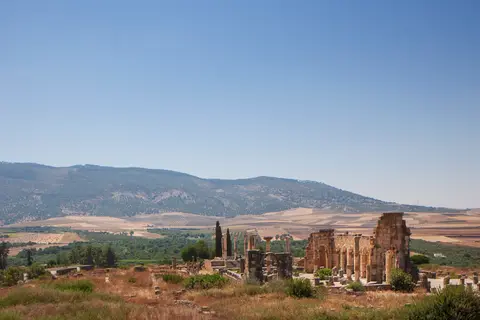
Volubilis occupies a sloping ridge at the foot of Jebel Zerhoun above the confluence of the Wadi Khoumane and the smaller Fertassa stream. From there, the site commands a fertile agricultural plain between the Prerif hills and the Gharb Basin north of Meknes. Archaeological excavations document human habitation here since the Late Atlantic Neolithic some 5,000 years ago, when local pottery shapes mirrored contemporaries across the Strait of Gibraltar in Iberia. Linguistic scholars link the classical name Volubilis (pronounced with an initial W sound in Latin) to the Amazigh word Walilt for oleander growing along the valley floor. Alternatively, it may derive from the Amazigh root WLLY meaning to turn or whirl, echoed in Horace's epistles and retained later in the Arabic name Walili.
By the third century BC, Carthaginian trade had established a strong proto-urban presence on the ridge, evidenced by Phoenician inscriptions, pottery finds and sanctuary remains dedicated to the Punic deity Ba'al. Long after Carthage fell to Rome in 146 BC, Punic civic institutions endured: local magistrates continued holding the Carthaginian title of suffete inside the independent Kingdom of Mauretania. In 25 BC, Roman Emperor Augustus placed the Roman-educated Numidian prince Juba II onto the Mauretanian throne. Juba II and his wife Cleopatra Selene II (daughter of Mark Antony and Cleopatra), followed by their son Ptolemy, established Volubilis as a second royal capital ornamented with Mediterranean sculpture and monumental masonry.
When the Roman Emperor Claudius annexed Mauretania in 44 AD following a four-year rebellion led by Ptolemy's freedman Aedemon (40 to 44 AD), Volubilis remained loyal to Rome. In reward, imperial authorities granted residents Roman citizenship and a 10-year tax exemption, elevating the town to the status of a municipium governed by annually elected pairs of duumvirs rather than Punic suffetes. First-century geographer Pomponius Mela praised Volubilis among the wealthiest small cities of Mauretania, while Pliny the Elder and the second-century Antonine Itinerary both recorded the flourishing settlement under the name Volubilis Colonia.
Municipal Status, Auxiliary Forts and Olive-Oil Prosperity
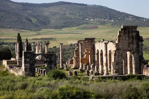
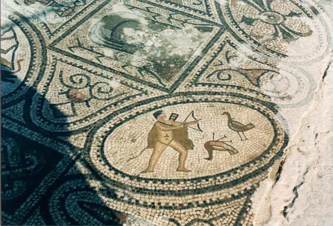
Economic prosperity through the second and third centuries rested upon fertile alluvial farmland producing export grain, olive oil and wild animals shipped to imperial arenas. At its late second-century peak, Volubilis housed roughly 20,000 inhabitants, mostly Romanised Berbers, while over 50 excavated rural villas dotted the surrounding plain. Wealthy landowners financed grand peristyle townhouses clustered along the gently sloping northeastern quarter, flooring dining rooms and reception halls with mythological mosaic pavements and decorating courtyards with marble and bronze statuary.
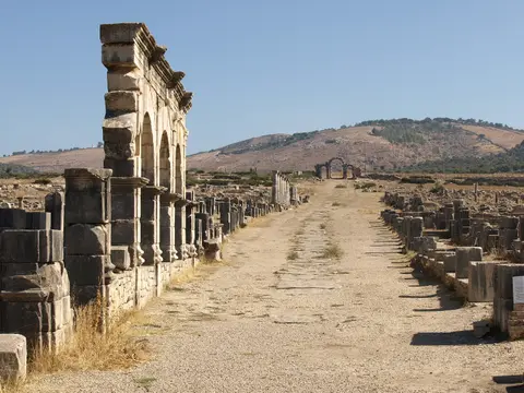
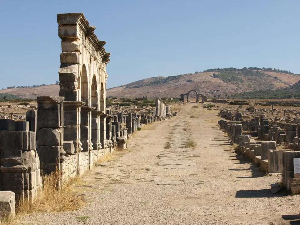
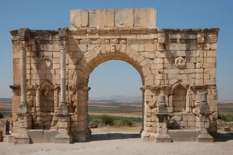
Urban planning at Volubilis adapted visibly to underlying terrain across its 42 hectares. On the gentler northeastern slope housing the monumental centre and the triumphal Arch of Caracalla, Roman engineers laid out an orthogonal hypodamian street grid anchored by the colonnaded Decumanus Maximus. On the steeper, craggier hills across the southern and western quarters, builders shifted to a stepped terraced plan conforming to the natural ridge. Standing at the southwestern frontier of the Roman province of Mauretania Tingitana, Volubilis remained linked by Roman roads northwestward to Lixus and the provincial capital Tingis (Tangier), yet possessed no eastern road link into Mauretania Caesariensis because autonomous Berber Baquates territory intervened.
Frontier security required heavy military backing from five auxiliary forts ringing the valley at modern Aïn Schkor, Bled el Gaada, Sidi Moussa, Sidi Said and Tocolosida at Bled Takourart. Sidi Said was garrisoned by the Cohors IV Gallorum equitata cavalry unit raised in Gaul, while Tocolosida housed Gallic and Syrian cavalry detachments. Aïn Schkor held Hispanic and Belgic cohorts, and Sidi Moussa posted a cohort of Parthian troops. Rising frontier tensions with autonomous Berber tribes near the end of the second century prompted Emperor Marcus Aurelius to order a limestone rampart. Measuring 2.5 to 2.6 kilometres in length, the wall featured 8 monumental gates and 40 defensive towers enclosing roughly 42 hectares. Epigraphic finds also confirm a third-century Jewish community leaving Hebrew, Greek and Latin funerary stones and menorah-shaped oil lamps, marking the southwesternmost ancient Hebrew inscription discovered in antiquity.
Late-Antique Continuity, Idrisid Foundations and French Colonial Digs
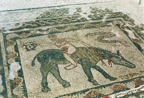
Roman administrative control receded during the Crisis of the Third Century. Around 280 AD, imperial rule collapsed across inland Mauretania, and in 285 Emperor Diocletian withdrew provincial boundaries northward to the coastal strip between Lixus, Tingis and Septa (Ceuta), judging inland reconquest too costly. Even without imperial legions, urban life persisted for at least 700 years. Fourth-century mosaics such as the animal-drawn chariot race in the House of Venus and Christian symbolism including a Good Shepherd statue survive from this era. Combined with sixth- and seventh-century Latin inscriptions dated by the provincial era, these finds prove that a Latinised Christian and Berber population remained. Earlier, a late fourth-century earthquake toppled public structures and sealed fine bronze statues beneath collapsed house masonry.
By the eighth century, Islamic conversion had reshaped the town under the name Oualila or Walili, inhabited by the Berber Awraba tribe from Libya. Much of the former monumental centre became a cemetery as habitation consolidated southwestward behind a shorter inner wall. Eighth-century Islamic coins concentrated outside the walls indicate that Arab settlers camped distinctly apart from the walled Berber core. In 787 to the following year, Idris I arrived at Walili under Awraba leader Ishaq ibn Mohammad, having fled Abbasid persecution after the Battle of Fakhkh in 787. A descendant of Prophet Muhammad, Idris I married Kanza of the Awraba and was proclaimed imam, founding the Idrisid dynasty of Morocco. He lived along the banks of Wadi Khoumane outside the walls in a recently excavated riverside headquarters complex. From there, he expanded rule across northern Morocco and founded Fes before his assassination in 791 on orders of Baghdad Caliph Harun al-Rashid. His son Idris II (also proclaimed imam at Volubilis) removed the royal capital to Fes upon reaching majority, while Andalusi exiles known as the Rabedis resettled at Volubilis in 818 after revolting in Córdoba.
Population drifted across to nearby Moulay Idriss Zerhoun between the eleventh and fourteenth centuries, where a grand mausoleum was built 3 kilometres away (roughly 1.9 miles). There, Leo Africanus noted walls and gates enclosing the tomb of Idris guarded by a couple of castles. Local folklore termed the ruined valley Ksar Fara'on (Pharaoh's Castle), later identified with ancient Volubilis by French diplomat Charles-Joseph Tissot (1828 to 1884). English antiquarian John Windus sketched standing arches in 1722, published in 1725 in A Journey to Mequinez. He recorded exact block dimensions for a triumphal archway 56 feet long and 15 thick with an opening 20 feet wide by 26 high. He also measured a squared front rising 140 feet long by 60 high behind a two-mile wall circumference before Moulay Ismail quarried marble columns for Meknes and the devastating 1755 earthquake flattened remaining standing porticoes. Visiting 95 years later in 1820, James Gray Jackson still noted two standing marble porticoes 30 feet high and 12 wide with coins dug from the ruins. Between 1887 and 1889, Walter Burton Harris described two surviving archways and an immense vaulted drain opening toward the little river.
Under the French Protectorate (1912 to 1955), colonial archaeologists built on nineteenth-century military surveys stretching back to the 1830s and 1850s across Algeria and North Africa. Excavating roughly half the 42-hectare town, they reconstructed the Basilica, Capitoline Temple and Arch of Caracalla to construct ideological links between classical Rome and French rule. In 1920, visiting American writer Edith Wharton noted that contrast between the classical ruins and the white sanctuary town of Moulay Idriss across the valley. Historians such as Gwendolyn Wright and Emile Pauty have examined how this colonial approach contrasted sharply with Islamic attitudes toward monuments and divine permanence. Protected today under Moroccan Law 22-80 (1981), the site gained clarified UNESCO boundaries and buffer zones approved in 2008. Ongoing management by the Volubilis Conservation Department and Ministry of Culture balances mosaic shelter maintenance and structural consolidation against seasonal winter weathering.
Complex Access Zones and Monument Sectors at Volubilis
Because roughly half the ancient town lies excavated across gentle ridges, visitors move cleanly from the southern pre-Roman and industrial quarters into the monumental Roman plaza and northeastern aristocratic avenue.
| Complex Zone | Key Highlights | Access & Ticket Rule |
|---|---|---|
| Monumental Forum, Basilica & Capitoline Temple | Reconstructed judicial basilica facade, elevated Capitoline temple podium, civic forum plaza and honorific Latin pedestals | Open-air monument terrace reached directly via stone walkways from the visitor museum; ropes guard fragile column plinths |
| Decumanus Maximus & Arch of Caracalla | Colonnaded northeastern avenue flanked by porticoed shops, triumphal Arch of Caracalla and North-Eastern aristocratic townhouses | Paved axial promenade open to pedestrians; protective low barriers surround exposed floor mosaics inside adjoining villa rooms |
| House of Venus & Mosaic Mansions | Peristyle residences retaining mythological mosaics in situ including the House of the Acrobat and fourth-century chariot mosaics | Viewed from perimeter gravel paths and raised masonry ledges; stepping onto exposed limestone tesserae pavements is strictly barred |
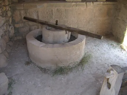
| Southwestern Olive Quarter & Punic Mound | Carved stone olive-crushing mills, press counterweights, ancient tumulus mound and eighth-century Idrisid riverbank remains | Accessible on rougher dirt tracks across the southern slope; sturdy footwear advised for uneven ground |
Three Archaeological Details to Examine at Volubilis
Inspecting masonry seams, industrial rooms and floor pavements highlights the everyday engineering behind Volubilis's long civic survival:
- Dual Topographical Street Layouts Across the Ridge: Compare the ruler-straight colonnades of the northeastern Decumanus Maximus with the winding stepped terraces around the southern olive-press quarter to see how Roman municipal surveyors merged regular hypodamian grids with pre-existing Mauretanian slope alignments.
- Counterweight Stone Blocks and Olive-Crushing Mills: Inside the excavated industrial workshops, locate the large notched limestone counterweight blocks and circular lever channels; these olive presses powered the agrarian exports that financed Volubilis's marble basilica and mosaic mansions.
- In-Situ Polychrome Mosaics and Drainage Channels: Examine how stone street drains along the Decumanus Maximus connect directly into aristocratic villa courtyards, protecting delicate floor mosaics such as the backwards-riding acrobat panel beneath winter rains. Keep an eye out for subtle mortar repairs distinguishing ancient tesserae from colonial consolidations.
Seasonal Timing and Connecting Volubilis with Rabat
Set amid rolling cereal hills and olive groves below Jebel Zerhoun, Volubilis offers minimal tree canopy across its exposed limestone terraces. Spring paints the surrounding slopes wildflower green under mild temperatures, while autumn keeps midday walking comfortable; summer visitors should arrive as gates open in morning coolness before heat radiates off pale paving stones across the valley floor.
Situated 56 kilometres from Fes Saïss International Airport (FEZ) and 119 kilometres east of Morocco's Atlantic capital, Volubilis pairs directly with our Rabat travel guide, linking inland Roman-Berber heritage and third-century olive workshops with coastal medieval and Almohad monuments. Compare other North African Roman cities and frontier fortifications inside our UNESCO World Heritage Atlas.