Quick Field Data
- UNESCO Inscription: Cultural World Heritage Site (Ref. 1058), inscribed in 2004 under Criteria (ii) and (iv).
- Scale & Footprint: 7.5 hectares inside the 250 by 300 metre star-shaped fortress enclosure along El Jadida's Atlantic bay, ringed by 8-metre-high ramparts 10 metres thick and a protected 50-metre outer ditch buffer zone.
- Access & Ticketing: Walled fortress lanes, rampart walkways, and the main Rua da Carreira spine are open free to pedestrians; the subterranean Portuguese Cistern operates as a ticketed monument.
- Arrival Logistics: Mohammed V International Airport (CMN) near Casablanca lies 86 km northeast; coastal highway links connect El Jadida with Morocco's capital Rabat, 176 km to the northeast.
Phoenician Anchorage to Portuguese Star Fortress
Standing along a sheltered Atlantic bay 90 to 96 km southwest of Casablanca, El Jadida occupies a natural coastal headland settled continuously since at least the 5th century BC. Phoenician mariners used the anchorage later recorded under historical names including Cap Soleis, Portus Rutilis, Rusibis, and Mazighan, first documented by the 11th-century Arab geographer al-Bakri. Throughout the Middle Ages and antiquity, trading boats sheltered here along the Atlantic coast of what is now Casablanca-Settat Province. In 1502, Portuguese captain Jorge de Mello was allegedly driven ashore by a storm. He and his crew took refuge inside an abandoned local watchtower known as al-Briya or al-Burayja to defend against local attacks. Upon returning to Portugal, Mello secured permission from King Dom Manuel in 1505 to construct a permanent stronghold, yet evidence shows he never built it. When a Portuguese expedition passed the bay in 1513 on its campaign to capture nearby Azemmour, soldiers found only the solitary ruined tower still standing above the water.
Because Azemmour's river bar proved difficult for ocean vessels to reach safely, Portuguese architects Diogo and Francisco de Arruda returned to accessible Mazighan in summer 1514. They erected a rectangular Citadel measuring 47 by 56 metres around four corner towers and three principal rooms arranged around a central hall, incorporating the older southern El-Briya Tower into its fabric. Soon after, rising Sa'did forces systematically expelled Portuguese garrisons along the Moroccan coast, culminating in the fall of Santa Cruz (Agadir) in 1541. King Joao III ordered the evacuation of Azemmour and Safi to concentrate naval and artillery defence at Mazagao, one of Portugal's key coastal waypoints on the Atlantic maritime route toward India.
Between 1541 and 1548, Italian military engineer Benedetto da Ravenna drafted plans executed by Joao Ribeiro and Joao de Castilho (Juan Castillo) to wrap the 1514 Citadel inside a massive Renaissance star-shaped artillery fortress measuring roughly 250 by 300 metres. Sloping masonry ramparts averaging 8 metres high and 10 metres thick enclosed a 2-metre peripheral patrol walkway designed to withstand cannon fire, protected externally by a seawater-filled defensive ditch roughly 20 metres wide and 3 metres deep. Three principal gates punctured the perimeter: the Seagate forming a small sheltered harbour at the northeast wall, the Bull Gate along the northwest rampart, and the main double-arch southern entrance linked to mainland roads across a drawbridge. Four corner bastions survive intact today, named Angel (east), Saint Sebastian (north), Saint Antoine (west), and Holy Ghost (south), where colonial-era Portuguese cannons still rest atop stone embrasures.
Manueline Vaults, Churches, and Nineteenth-Century Revival
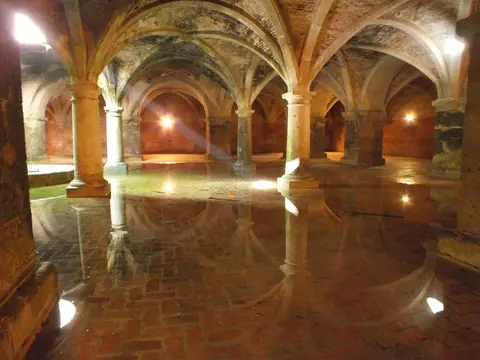
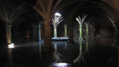
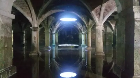
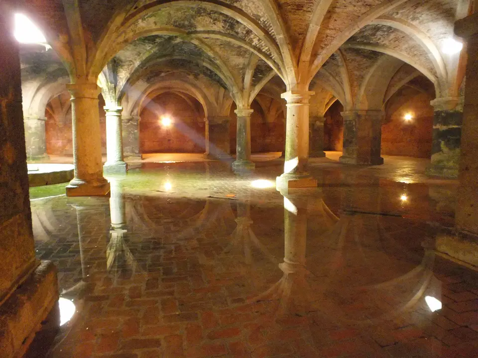
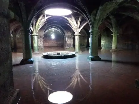
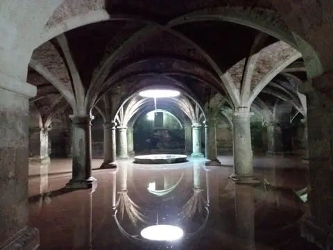
Running straight through the fortress from the seaside entrance toward the interior runs Rua da Carreira, preserving the compact urban spine of Portuguese Mazagao where the best-conserved historic monuments cluster. Beneath the central 1514 Citadel lies the fortress's architectural focal point, the subterranean Portuguese Cistern. Designed by Miguel de Arruda and built by Joao de Castilho, the semi-subterranean square chamber measures 33 to 34 metres per side and rests on five rows of five stone pillars and columns supporting late-Gothic Manueline brick-masonry vaults laced with carved stone ribs. Scholars debate whether the hall originally functioned as an armoury, barracks, or granary in 1514 before formal conversion into a rainwater reservoir in 1541 fed through a central ceiling oculus.
South of the Citadel rises the Church of Our Lady of the Assumption, begun during the 1541 expansion as Mazagao's primary parish church with a nave, choir, sacristy, and square-shafted bell tower. Historically, the Church of Mercy (Misericordia) stood inside the Citadel alongside two smaller chapels built against fortress bastions. Portuguese rule endured until 1769, when forced evacuation ended Portugal's last Moroccan enclave. Before sailing away (most inhabitants were sent to the colony of Brazil, where they established Nova Mazagao in present-day Amapa state), departing troops mined and destroyed the Governor's Bastion guarding the main southern gate.
Captured by Sultan Mohammed ben Abdallah in 1769, the deserted shell earned the name al-Mahdouma ("The Ruined") until early 19th-century reconstruction under Sultan Abd al-Rahman (reigned 1822 to 1859). He commissioned a mosque using one northern Citadel tower as the minaret base, restored damaged rampart sectors, and oversaw the renaming of the town to al-Jadida ("The New") in 1820. Revitalised as a thriving commercial port where Muslim, Jewish, and Christian residents lived and traded together, the town soon outgrew neighbouring Azemmour and preserved visible monuments to Jewish heritage. Notably, the Bensimon Synagogue was inaugurated in 1926 in the northern corner through sponsorship by the four Bensimon brothers (Nessim, Messaoud, Abraham, and Mordechai). It sits attached directly to earlier structures within the former fortress wall.
Under the French Protectorate established in 1912, El Jadida developed into one of Morocco's earliest modern seaside resorts, opening a casino popular with European visitors by the 1930s. South of the old city and port, Mauresque-style colonial architecture now houses the Museum of Resistance and Independence commemorating Moroccan soldiers and resistance to protectorate rule. As Casablanca rose to dominate national port trade, El Jadida anchored regional industry and higher education through the Office Cherifien des Phosphates complex opened 20 km south at Jorf Lasfar in the 1980s. The town also hosts Chouaib Doukkali University's science, humanities, legal, and engineering faculties, alongside coastal tourism initiatives including the 2009 Mazagan Beach Resort beside Azemmour under King Mohammed VI's 2001 coastal tourism strategy. Unlike isolated ruins left empty after imperial withdrawals, the historic walled enclosure remained woven into daily Moroccan civic, academic, and port life.
Earthquake Vulnerability, Buffer Zones, and Civic Stewardship
Mazagan is protected under Moroccan Law 22-80 (1981) and managed through the Morocco-Lusitanian Heritage Centre for Study and Research (CERPML) in coordination with the Ministry of Culture, provincial authorities, and the Urban Agency. Because families continue living and trading inside the 7.5-hectare enclosure, the site faces different preservation pressures than abandoned archaeological ruins. Following the 2004 UNESCO listing, strict architectural specifications were adopted together with a 50-metre non aedificandi protection zone preserving the footprint of the former perimeter moat. French engineers had earlier filled that moat with earth to open a modern entrance gate leading straight to Rua da Carreira and the Seagate. Starting in October 2008, urban clearance and port-front works sought to improve visibility across the eastern fortifications and uncover sections of the historic ditches.
Modern structural monitoring gained sharp urgency in September 2023 when the southern Morocco earthquake struck the region. Tremors opened structural cracks across the bell tower of the historic Portuguese Church of Our Lady of the Assumption and raised serious collapse concerns by 13 September 2023. Maintaining strict height controls in modern El Jadida (home to 237,564 residents in 2024) inside and outside the buffer zone remains equally vital. This prevents new construction from obscuring the Atlantic silhouette of the 16th-century star bastions above the port. Ongoing heritage governance relies on municipal architectural regulations and community participation by local residents who view the Portuguese-Moroccan enclosure as shared urban fabric. Phased rehabilitation projects led by the Morocco-Lusitanian Heritage Centre for Study and Research in coordination with provincial authorities give preserved buildings compatible civic and cultural functions without erasing older limewashed walls, cistern vaults, or street alignments. Plans coordinated between CERPML and municipal partners continue updating the site's formal conservation management framework.
Fortress Bastions, Cistern, and Historic Street Access
Because the entire 7.5-hectare fortified precinct forms a compact walking grid above the Atlantic harbour, visitors can trace every historical layer on foot between the sea walls and central Citadel courtyard. From upper bastion embrasures along the 2-metre peripheral patrol path, routes lead directly down into Rua da Carreira's parish churches, historic mosques, Jewish courtyard houses, and the vaulted subterranean cistern.
| Complex Zone | Key Highlights | Access & Ticket Rule |
|---|---|---|
| Ramparts, Bastions, and Gates | Angel, Saint Sebastian, Saint Antoine, and Holy Ghost bastions with historic cannons, 2 m patrol walkway, Seagate, and Bull Gate | Walls and upper bastions generally free to walk; exercise care along unrailed Atlantic parapets and ruined Governor's Bastion |
| Portuguese Cistern and Citadel | Square 33 to 34 m underground vaulted chamber on five rows of five columns beneath the 1514 Citadel and repurposed minaret tower | Ticketed heritage entry; damp stone paving can feel slick around the central reflecting water pool |
| Rua da Carreira and Parish Churches | Main Portuguese street spine, Church of Our Lady of the Assumption, and historic residential houses | Public street free to walk; church interior access subject to structural repairs following the September 2023 earthquake |
| Northern Quarter and Bensimon Synagogue | 19th- and 20th-century multicultural dwellings and the 1926 Bensimon Synagogue in the northern fortress angle | Exterior facades visible from public lanes; verify interior synagogue opening status locally before visiting |
Check current municipal access rules and post-earthquake safety barriers around the Church of Our Lady of the Assumption on official heritage channels before entering individual monuments.
Oculus Reflections, Tower Reuse, and Bastion Masonry at Mazagan
Three specific structural details inside the small fortress capture how European military geometry and Moroccan civic reuse overlapped over five centuries:
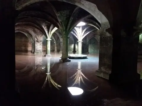
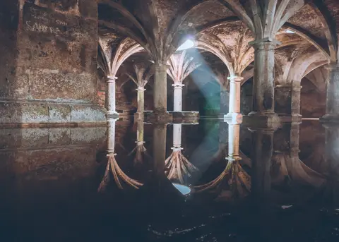
- Mirror water and Manueline stone ribs in the Cistern: Inside the square subterranean hall, daylight drops solely through the central rainwater oculus. It strikes a thin film of water covering the floor between five rows of five stone piers, producing the inverted architectural reflections photographed by filmmakers such as Orson Welles for Othello.
- Pre-Portuguese El-Briya Tower and minaret conversion: At the 1514 Citadel core, compare the surviving southern El-Briya Tower where Jorge de Mello sheltered in 1502 with the northern Citadel corner tower adapted during 19th-century Moroccan rebuilding to carry a mosque minaret.
- Inclined cannon ramparts and destroyed Governor's Bastion: Walk along the 2-metre peripheral wall path where 10-metre-thick sloping stone ramparts deflected artillery, stopping above the southern breach where retreating Portuguese troops detonated the Governor's Bastion in 1769.
Atlantic Climate Timing and Pairing El Jadida with Rabat
El Jadida experiences a hot-summer Mediterranean climate (Koppen Csa) moderated by Atlantic breezes, with winter bringing substantially more rainfall than dry summer months. Annual temperatures average 17.4 degrees Celsius with a modest seasonal temperature fluctuation of 9.8 degrees Celsius, peaking around 23.5 degrees Celsius in August and cooling to 13.6 degrees Celsius in January. Annual precipitation averages roughly 372 mm with a 60 mm gap between the wettest month (December, averaging 7.33 rain days) and the driest month (July, 0.20 rain days). Relative humidity shifts gently from 72.59 in May to 80.13 in January. Crisp morning light outside summer afternoon glare keeps rampart walks comfortable and illuminates the cistern's overhead oculus shaft cleanly across the floor pool. Travellers tracing Moroccan coastal fortifications and Euro-Maghrebi port history can pair Mazagan with Rabat, 176 km northeast up the Atlantic seaboard, or explore other fortified cities in the UNESCO World Heritage Atlas.