


























Quick Field Data
- UNESCO Inscription: 1986, and placed on the World Heritage in Danger roster from 1986 onwards (Criteria i, iii; largest pre-Columbian earthen architecture metropolis in the Americas and hierarchically planned capital of the Chimú Kingdom).
- Scale & Footprint: Spans approximately 20 square kilometres (7.7 square miles or 4,900 acres, with a 1,414.57-hectare inscribed zone) around a 6-square-kilometre (2.3-square-mile or 1,500-acre) monumental core containing nine to ten walled royal citadels (ciudadelas) in the Moche (Santa Catalina) Valley, La Libertad Region, Peru.
- Access & Ticketing: Administered by the Peruvian cultural authorities; public visits focus on the restored Tschudi walled compound (Palace) and the Museo de Sitio at Chan Chan, so check the official site before visiting.
- Arrival Logistics: Located at the mouth of the Moche Valley beside the Pacific Ocean in northern Peru, 5 kilometres (3.1 miles) west of the city of Trujillo in the department of La Libertad.
Rise of the Chimor Empire, Andean Canal Engineering, and the 1470 Inca Conquest
Situated at the mouth of the Moche (or Santa Catalina) Valley directly beside the Pacific Ocean, 5 kilometres (3.1 miles) west of modern Trujillo in the department of La Libertad in northern Peru, Chan Chan (sometimes called Chimor) was founded around 850 to 900 AD and served until 1470 as the imperial capital of the Chimor kingdom, a conquest state that developed out of the coastal Chimú culture and reached its apogee in the 15th century with an estimated urban population of 40,000 to 60,000 people. While early scholars proposed fanciful origins for the name Chan Chan (such as H. Bauman's Mesoamerican snake theory, J. Kimmich's Cariban moon claim, or Ernst Middendorf's Mochica root xllang for sun), linguists Jorge Zevallos Quiñones and Matthias Urban attribute the toponym (recorded as Cauchan in the 1536 Trujillo town council foundation act and Canda by Gonzalo Fernández de Oviedo before stabilizing as Chanchan in the mid-17th century) to the extinct Quingnam language spoken by the Chimor people, whereas Rodolfo Cerrón-Palomino proposes a Quechumaran derivation from kanĉa (meaning corral or fenced place).
Because the northern Peruvian coastal desert receives almost no rainfall, the survival and expansion of the 20-square-kilometre adobe metropolis depended entirely on managing surface runoff from the Andes. Initially supplied by deep freshwater wells dug approximately 15 metres into the water table, the Chimú engineered a vast irrigation network diverting water from the Moche and Chicama rivers through canals stretching up to 20 miles (and an approximately 80-kilometre inter-valley canal system) to irrigate extensive agricultural fields spreading north, west, and east of the urban perimeter. After a catastrophic El Niño flood around 1100 AD destroyed many northern canals, the Chimú rulers (governed by the Chimucapac) refocused their economy toward tribute and craft production.
That dependence on exposed mountain canals eventually sealed the capital's fate: around 1470 AD, invading Inca armies cut the Moche Valley irrigation channels supplying Chan Chan, forcing the city's surrender and dispersing its skilled artisans across the Inca Empire under the Mitma system of ethnic dispersion. Sixty-five years later, in 1535, Spanish conquistador Francisco Pizarro founded nearby Trujillo, and colonial treasure hunters systematically plundered Chan Chan's royal burial mounds, with one colonial archive inventory recording looted tomb gold valued at 80,000 pesos (equivalent to almost 5,000,000 in gold currency). Modern scientific excavations began in 1969 under archaeologists Michael Moseley and Carol J. Mackey and continue today under Peruvian and international teams.
Nine Royal Ciudadelas, Maritime Adobe Friezes, and Stratified Artisan Quarters
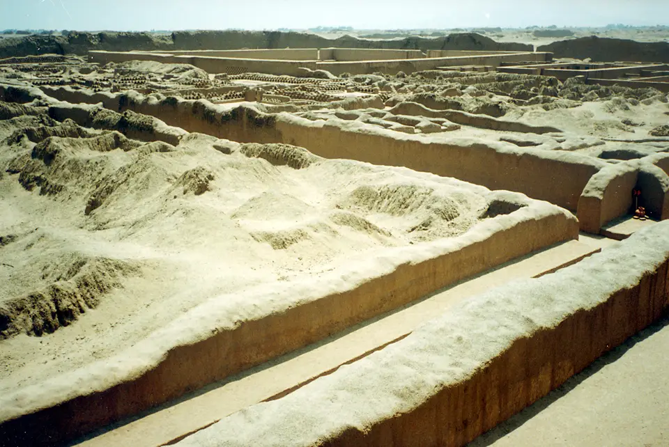
Considered the largest adobe mud city in the Americas and the second largest in the world, Chan Chan reflects a strict social and political hierarchy expressed in its Chimú creation myth, which held that the sun created three eggs: a gold egg for the rulers and elite, a silver egg for royal spouses, and a copper egg for commoners. Although the Quingnam administrators left no written script or surviving blueprints (leading anthropologists to theorize that builders recorded measurements on knotted cord khipus), the 6-square-kilometre central monumental zone is laid out with rigorous geometric discipline around nine (or ten, of which four have been recovered) autonomous rectangular royal compounds known as citadels, palaces, or ciudadelas.
Each ciudadela was erected for a successive Chimucapac ruler or deity and enclosed by massive battered adobe brick walls rising 12 to 18 metres (40 to 60 feet) high, engineered with bases 5 metres thick tapering to 1 metre at the summit to withstand coastal earthquakes. On the triangular city plan, no enclosures open to the north so that the north-facing walls absorb sunlight against coastal fog while the tallest ramparts block south-westerly winds off the Pacific Ocean. Entered through a single narrow gateway for strict security, each citadel is subdivided into northern, central, and southern sectors containing open ceremonial plazas, three-sided administrative courts called audiencias (frequently depicted on Chimú funerary ceramics), dense rows of storehouses, deep walk-in water reservoirs, and a royal funerary burial platform (such as the mausoleum uncovered in 2026 in the Utzh An complex containing more than 30 individuals, alongside the early Middle Horizon ceremonial funerary platform of Huaca Arco Iris, restored in 1963).
Surrounding the nine royal citadels spread thirty-two semi-monumental compounds for the nobility alongside four industrial production sectors and dense neighbourhoods of small, irregular agglutinated rooms (SIARs) where lower-class artisans lived and worked, weaving fine textiles, carving wood, firing ceramics, and working gold, silver, and copper. Across the smooth mud-plastered walls of the citadels, Chimú sculptors carved detailed bas-relief friezes in both realistic and stylized geometric patterns celebrating the Pacific Ocean cult: rows of fish swimming north and south (symbolising the cold Humboldt current from the south and the warm El Niño current from the north), breaking waves, rhomboid fishing nets (rombito) for harvesting Spondylus shells, crabs, turtles, pelicans, and composite sea-lion and otter figures known as anzumitos.
Visiting the Tschudi Palace, Audiencias, and the Site Museum
Because most of the fragile 20-square-kilometre adobe ruin field is closed to prevent footfall erosion, public exploration concentrates on the restored Walled Compound Tschudi (named after Swiss chronicler von Tschudi and believed to honour the Chimú sea deity) and the peripheral monuments west of Trujillo.
- Entering the Single Gate of the Tschudi Citadel: Approach the 12-metre-high seismic-tapered adobe perimeter walls of the Tschudi compound (the only ciudadela open to tourists) and pass through its single fortified entrance into the main ceremonial plaza, where restored mud-plaster reliefs display stylized waves alongside rombito fishing nets, pelicans, and anzumitos.
- Tracing the Audiencias, Ceremonial Pond, and Royal Burial Platform: Follow the labyrinthine corridors through the central sector of Tschudi to inspect the three-sided audiencias (where royal officials controlled access to the storehouses), the huge sunken rectangular reservoir pond at the heart of the palace used for water and fertility ceremonies, and the southern funerary platform where the deceased ruler was entombed.
- Exploring the Museo de Sitio and Huaca Arco Iris: Visit the Museo de Sitio at Chan Chan (where the Getty Center established its mud architecture conservation course in 1994) to examine Chimú metalwork, textiles, and ceramics modeling audiencias, then travel to the outlying adobe pyramid of Huaca Arco Iris on the edge of Trujillo.
El Niño Storms, Drone Photogrammetry, and World Heritage in Danger
Inscribed by UNESCO and added to the World Heritage in Danger roster on 28 November 1986 (and further threatened by a May 2025 spray-paint vandalism incident), Chan Chan faces severe erosion from El Niño rainstorms, rising coastal groundwater, salt crystallization, and vegetation growth across 46 critical damage points identified under Peru's 1998 Master Plan for Conservation and Management (drawn up with ICCROM, the Getty Conservation Institute, and the World Heritage Foundation). Alongside protective rain shelters and drainage channels funded by the regional government of La Libertad, the Italian Mission in Peru (working since 2002, including Roberto Pierdicca's 2017 to 2018 drone and ground photogrammetry at Tschudi Palace using 1,856 aerial and 105 ground images in compliance with the Seville Principles and London Charter, and the 2016 to 2022 CNR and CONCYTEC 3-D Heritage Building Information Model project at Huaca Arco Iris) documents the fragile mud-brick friezes for posterity. Together, these ongoing earthen conservation programmes, protective canopies, and high-resolution digital surveys work to safeguard the adobe walls, audiencias, and maritime bas-reliefs of the Chimor capital against future coastal storms; you can discover more pre-Columbian Andean cities in our UNESCO World Heritage Atlas.
