


























Quick Field Data
- UNESCO Inscription: 1990 · Extended 1992 · Mixed Site · Criteria (iii), (vii), (ix), (x).
- Scale & Footprint: 274,520 hectares (2,745.2 km2, also listed as 272,407.95 ha) covering 70% of the Abiseo river basin between 350 and 4,200 metres elevation in San Martín Region, Peru
- Access & Ticketing: Managed by SERNANP as an IUCN Category II national park; closed to general public tourism since 1986 to safeguard its fragile montane ecosystems and 36 pre-Columbian archaeological sites
- Arrival Logistics: Situated in Huicungo District of San Martín Region between the Marañón and Huallaga rivers along the eastern Andean mountain slopes of north-central Peru
Andean Cloud Forests, Pleistocene Refuges as well as Endemic Primate Habitat
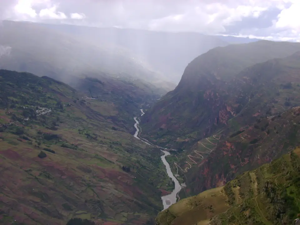
Situated between the Marañón and Huallaga rivers in the Huicungo District of Peru's San Martín Region at coordinates 7.7500 S and 77.2500 W along the eastern Andean mountain slopes of north-central Peru, Río Abiseo National Park (known in Spanish as Parque Nacional del Río Abiseo) safeguards an extraordinary combination of montane rainforest biodiversity and pre-Inca archaeological heritage. Mist and moss cloak ancient stone ridges here. Established by the Peruvian government on 11 August 1983 under decree 064-83-AG, inscribed by UNESCO as a Mixed World Heritage Site in 1990 alongside extended in 1992 under Criteria (iii), (vii), (ix) as well as (x), the park covers 274,520 hectares (approximately 2,745.2 square kilometres, with World Heritage datasheets also citing 272,407.95 hectares) and encompasses 70% of the entire Abiseo river drainage basin.
Topography inside the park rises nearly four vertical kilometres, climbing from lowland valleys at 350 metres (1,150 feet) above sea level to high Andean peaks reaching 4,200 metres (13,780 feet). Across this steep altitudinal gradient, the reserve safeguards three major ecoregions, ranging from low-elevation Ucayali moist forests through mid-altitude Peruvian Yungas up to high-altitude Cordillera Central páramo grasslands, alongside at least seven distinct climate zones including dry forest, montane forest, montane rainforest, tropical alpine forest, and high Andean grasslands (puna or páramo). Above approximately 2,300 metres (7,550 feet), where constant humidity and year-round precipitation ranging from 20 to 80 inches (up to 2.0 metres) per annum drench the acidic soils, the landscape is dominated by montane cloud forest carpeted in short gnarled trees, thick mosses as well as lichens.
Biologists recognise the Río Abiseo forests as a Pleistocene refuge, an isolated mountain sanctuary where tropical flora and fauna survived and evolved during past glacial epochs when cooler, drier conditions shrank lowland rainforests. That evolutionary isolation produced exceptional botanical richness and endemism: surveys have documented 5,000 plant species across the broader Río Abiseo area, including 980 known plant species in the park's highlands alone, 13 of which are strictly endemic to the reserve.
The catalyst for creating the national park in 1983 was the rediscovery of the critically endangered yellow-tailed woolly monkey (Oreonax flavicauda). Previously believed to be extinct, this large primate survives only in the humid montane cloud forests of this region and is considered endemic to the area. Sharing the cloud forests and high grasslands are endangered mammals and birds including the spectacled bear (Tremarctos ornatus), the Peruvian guemal or taruca (Hippocamelus antisensis), the mountain paca or punatuacher (Agouti tazcanowskii), the white-fronted spider monkey (Ateles belzebuth), the russet-mantled softtail (Phacellodomus berlepschi) alongside the yellow-browed toucanet. Across the canopy and river canyons also live the jaguar (Panthera onca), Venezuelan red howler (Alouatta seniculus), three-striped night monkey (Aotus trivirgatus), white-fronted capuchin (Cebus albifrons cuscinus) alongside the hairy long-nosed armadillo (Dasypus pilosus), Andean guan (Penelope montagnii), Salvin's curassow (Crax salvini), king vulture (Sarcoramphus papa), turkey vulture (Cathartes aura), southern pochard duck (Netta erythrophthalma), and yellow-crowned amazon (Amazona ochrocephala).
Eight Millennia of Pre-Inca Settlement, Gran Pajatén, and Los Pinchudos
Beneath the dense canopy and across the high páramo grasslands, archaeological research undertaken since 1985, led extensively during the mid-1980s by researchers from the University of Colorado, has recorded 36 previously unknown pre-Columbian archaeological sites at altitudes between 2,500 and 4,000 metres. Spread across an archaeological zone exceeding 150,000 hectares within and bordering the reserve, 29 of these recorded sites occupy the high-altitude páramo grasslands whereas seven lie concealed beneath the continuous montane forest canopy. Examined extensively during the mid-1980s by archaeological field teams led by the University of Colorado, this concentration of pre-Columbian settlements demonstrates that the steep eastern Andean cloud forests and high grasslands supported dense, organised pre-Inca populations for thousands of years.
Together, these 36 sites document at least eight millennia of human history prior to the Inca Empire. At Manachaqui Cave and neighbouring rock shelters, stratified deposits trace pre-ceramic hunting and gathering bands and early trade links that reached across the cordillera to the Pacific Coast and north into what are today the Ecuadorian Andes. Across the upper slopes and forested ridges, pre-Inca builders constructed stone road networks, agricultural terraces, storage structures, stone fences, ceremonial platforms, domestic dwellings, and cliff burial complexes at sites including La Playa, Las Papayas, and Cerro Central.
The architectural centrepiece of the cloud forest is Gran Pajatén, a pre-Columbian settlement built high on a wooded mountain ridge above the canyon of the Montecristo River and attributed by scholars to the pre-Inca Chachapoyas culture. Together with the cliffside funerary chambers of Los Pinchudos, which villagers from Pataz first encountered in the early 1970s, alongside the ceremonial platforms, agricultural terraces, storage structures, stone roads, and burial sites at Cerro Central, Las Papayas, La Playa, and Manachaqui Cave, these monuments illustrate a sophisticated highland society that maintained long-distance trade networks reaching across the Andes to the Pacific Coast and north into the present-day Ecuadorian Andes. Famous for its circular stone buildings decorated with slate-mosaic friezes of winged human figures and geometric frets, Gran Pajatén stands near the cliff tombs of Los Pinchudos, a series of wooden-roofed funerary chambers built into a sheer rock ledge that were discovered by villagers from Pataz in the early 1970s. Looking ahead, because both the Chachapoyas masonry and the surrounding cloud-forest habitat are extremely fragile, Peru's national protected areas agency SERNANP has kept the core park closed to general tourism since 1986.
Understanding the 1986 Conservation Closure and Buffer-Zone Approaches
Because SERNANP strictly restricts entry into the core of Río Abiseo National Park to accredited scientific and conservation expeditions, travellers cannot hike independently to Gran Pajatén or Los Pinchudos, but can explore the surrounding Huallaga and Marañón buffer landscapes and regional museums in northern Peru.
- Respecting the 1986 SERNANP scientific closure of the core zone: Note before planning any trip to San Martín Region that the interior of Río Abiseo National Park (including the ridge ruins of Gran Pajatén, the cliff tombs of Los Pinchudos, Manachaqui Cave, Cerro Central, La Playa, and Las Papayas) has been closed to general tourist access since 1986 to prevent trail erosion and microbial damage to the Chachapoyas stonework and yellow-tailed woolly monkey habitat.
- Exploring the Huicungo District buffer zone and El Breo waterfalls: Authorised community ecotourism circuits operating in the lower Huallaga and Abiseo buffer approaches around Huicungo District allow visitors to travel by boat and forest trail to natural landmarks on the park periphery such as the El Breo waterfalls (Cataratas del Breo), experiencing the lower Ucayali moist forest and Peruvian Yungas transition zones where orchids, bromeliads, and endemic Andean birdlife flourish, including the Andean guan, yellow-browed toucanet, russet-mantled softtail, king vulture, and yellow-crowned amazon.
- Connecting Chachapoyas heritage across northern Peru: To examine Chachapoyas circular stone architecture, cliff sarcophagi, and cloud-forest ecology similar to the protected monuments inside Río Abiseo, pair your northern Peru research with the accessible Chachapoyas sites in the wider Marañón and Huallaga region of northern Peru where the high-altitude páramo grasslands between 2,500 and 4,000 metres and the humid montane cloud forests above 2,300 metres preserve eight millennia of pre-Columbian occupation alongside 980 highland plant species (13 endemic) and 5,000 regional flora species. Because protecting the critically endangered yellow-tailed woolly monkey (Oreonax flavicauda), the spectacled bear (Tremarctos ornatus), the Peruvian guemal (Hippocamelus antisensis), and the mountain paca (Agouti tazcanowskii) together with the fragile stonework of Gran Pajatén and Los Pinchudos remains the top priority of SERNANP under decree 064-83-AG, travellers should consult Iperu tourist information offices in San Martín alongside our UNESCO World Heritage Atlas.
