


























Quick Field Data
- UNESCO Inscription: 1985 (Natural Criteria vii, viii)
- Scale & Footprint: 340,000 hectares (840,000 acres) spanning the Cordillera Blanca high mountain range in the region of Ancash
- Access & Ticketing: Administered by Peru's protected natural areas agency (SERNANP); check the official site for single-day and multi-day trekking permits
- Arrival Logistics: Accessed primarily from the nearest city of Huaraz in the Santa River valley of Ancash, north of Lima by paved highway
The Highest Tropical Mountain Range in the Central Andes
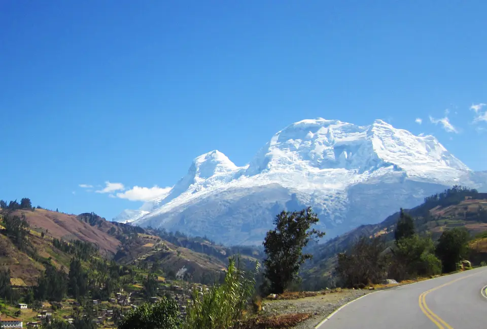
Stretching for approximately 150 kilometres (93 miles) from north to south and averaging about 25 kilometres (16 miles) in width along the rugged spine of the Cordillera Blanca ("White Mountains") in the region of Ancash in central Peru, Huascarán National Park protects the heart of the highest glaciated tropical mountain range on the planet. Established by the Peruvian government on 1 July 1975 by decree No. 0622-75-AG, recognised by UNESCO as the core of a Biosphere Reserve in 1977 (which also encompasses the populated Santa River valley outside the park boundaries), and inscribed in the UNESCO World Heritage Atlas in 1985 under natural criteria vii and viii, the park covers 340,000 hectares (840,000 acres) of high mountain wilderness. Taking its name from the 16th-century Inca leader Huascar and crowned by the dramatic massif of Nevado Huascarán (Mount Huascarán), whose highest summit reaches 6,768 metres (22,205 feet) above sea level as Peru's highest peak, the park encompasses an elevational range from around 2,500 metres (8,200 feet) up to 27 snow-capped peaks rising above 6,000 metres (20,000 feet), including Huandoy, Copa, alongside Huantsán. Ice fields gleam above deep ravines.
Geologically and hydrologically, the Cordillera Blanca forms the continental divide of the central Peruvian Andes. Its western slopes drain to the Pacific Ocean via the northward-flowing Santa River, whereas its eastern slopes drain via torrential mountain creeks into the Marañón River, which carries Andean meltwater toward the Amazon River before reaching the Atlantic Ocean. Legislative efforts to protect this alpine ecosystem began during 1960, when Peruvian Senator Augusto Guzmán Robles introduced a parliamentary bill before the Peruvian Congress proposing the establishment of Huascarán National Park. Three years later, in 1963, government specialists at the Servicio Forestal y de Caza (the national Forestry together with Hunting Service) prepared an initial reserve boundary covering 321,000 hectares (or 790,000 acres). On 18 February 1966, national authorities issued an official government resolution banning both timber cutting and wildlife hunting of native species across the Cordillera Blanca, while later in 1966 civic leaders in Yungay organised the Patronage of Huascarán National Park to support local conservation. In 1967, Peace Corps volunteers Curry Slaymaker and Joel Albrecht formulated a delimitation proposal covering 85,000 hectares (210,000 acres), while the Forest Regional Service of Huaraz simultaneously established a surveillance zone of 10,000 hectares (25,000 acres) to safeguard the vicuña alongside the Queen of the Andes, paving the way for compensated land expropriation by the state and the definitive 340,000-hectare national park creation in July 1975. Although the park boundaries avoided including permanent settlements wherever possible, neighbouring rural communities continue to graze livestock in several valleys under park regulation.
Tropical Glaciology together with Mountain Climate
Within the boundaries of Huascarán National Park, geographical surveys have recorded 660 tropical glaciers, constituting the largest glaciated area anywhere in the tropics, accompanied by 300 turquoise glacial lakes plus elevated plateaus cut by steep U-shaped valleys and ravines watered by torrential creeks. Situated at around 9 degrees south latitude in the intertropical zone, the mountain range experiences two well-defined seasonal regimes rather than four temperate seasons: a rainy season lasting from December to March, when frequent thunderstorms sweep across the range and clothe the valleys and slopes in shades of green with daily temperatures ranging from a maximum of 20 degrees (68 degrees on the imperial scale) to a minimum of 5 degrees (41 degrees), followed between April and November by a pronounced dry season that brings almost daily sunshine alongside cloudless, cold nights with daytime highs reaching 24 degrees (75 degrees) and minimums dropping to 2 degrees (36 degrees) in the valleys and sub-zero frosts on the high passes.
Because these 660 tropical glaciers are highly sensitive to atmospheric warming, the park functions as an international research laboratory for meteorology, geology, glaciology, botany, limnology, zoology, ecology, together with wildlife management. Across the high cirques and moraines, meltwater streams feed crystal-clear turquoise lagoons that supply year-round water to the farming communities of the Santa River valley and the eastern Marañón tributaries. Conservation authorities at SERNANP work continuously to address environmental pressures across the reserve, including rapid glacier retreat linked to global warming, downstream hydropower projects, authorised as well as unauthorised mining operations operating under low environmental standards, plus the loss of native plant diversity to agricultural expansion and pasture grazing where park conservation goals intersect with ancestral land rights claimed by local highland communities.
High-Andean Biodiversity and the Queen of the Andes
Transitioning across subalpine, alpine, together with tropical tundra climates from lower montane tropical forest pockets in sheltered ravines to expansive paramo, puna grasslands, plus high scrublands, Huascarán National Park supports 779 identified species of high-Andean flora alongside diverse mammalian and bird communities:
- The Queen of the Andes (Puya raimondii): Recognised as the signature conserved plant inside the reserve, Puya raimondii (the Queen of the Andes) flourishes across the high puna slopes alongside characteristic Andean shrubs, trees, plus tussock grasses including Polylepis racemosa, Alnus acuminata, Escallonia resinosa, Vallea stipularis, Senna birostris, Lupinus, Calamagrostis vicunarum, Vaccinium floribundum, Jarava ichu, Festuca dolichophylla, plus Azorella.
- Relict Polylepis and Buddleja Forests: Sheltered inside steep glacial ravines and mountain slopes, scattered high-Andean forests of the genera Polylepis and Buddleja form high-elevation woodlands that stabilize valley soils, retain mist, and rainwater, plus shelter mountain wildlife against freezing night winds.
- Charismatic Andean Mammals: Field biologists have recorded over ten mammalian species across the park, led by the emblematic vicuña, which came close to extinction in the 1960s before recovering into one of South America's major conservation successes, alongside the vulnerable spectacled bear, the endangered Andean mountain cat, the colocolo, the puma (mountain lion), the taruca (North Andean deer), the white-tailed deer, the northern viscacha, the hog-nosed skunk, the long-tailed weasel, plus the Andean fox.
- Andean Condor Valleys and 33 Archaeological Sites: More than 120 bird species inhabit the valleys and lagoons, including the Andean condor, torrent duck, puna tinamou, brown pintail, Andean crested duck, giant hummingbird, yanavico, white-tufted grebe, giant coot, chiguanco thrush, plus Andean gull. Culturally, 33 archaeological sites lie within the park, preserving cave paintings, ancient settlements, agricultural terraces, tombs, fortresses, plus irrigation works, linked by a pre-Columbian road running between the towns of Olleros and Chavin.
Trekking Circuits together with Park Entry Logistics
Huascarán National Park offers 25 official trekking routes and 102 mountaineering spots suitable for hiking, wildlife watching, mountain biking, skiing, plus high-altitude climbing across the peaks of Huascarán, Huandoy, Copa, alongside Huantsán. Every year, international mountaineers, and trekkers gather in the Santa River valley to traverse the U-shaped glacial gorges and high mountain passes that connect the western and eastern slopes of the range, admiring the dramatic juxtaposition of snow-capped summits, turquoise glacial lakes, and ancient pre-Columbian stone pathways. Because the park spans such an immense vertical relief between 2,500 metres and 6,768 metres above sea level, hikers can move within a single day from warm valley floors lined with flowering shrubs up into sub-zero glacial basins below sheer granite and ice faces.
- Entry and Route: Most travellers base themselves in the nearest city of Huaraz or in Yungay inside the Santa River valley of Ancash, reached by paved highway north from Lima. From the valley towns, mountain roads climb eastward into the glacial valleys and trailheads of the Cordillera Blanca, where transport collectives and chartered mountain vehicles drop hikers at the valley ranger posts.
- Tickets and Viewpoints: SERNANP ranger stations at the valley entrances regulate visitor access and issue single-day or multi-day trekking and climbing permits; check the official site before arrival for current registration rules and authorised guide requirements, particularly when planning technical ascents on the glaciated peaks of Huascarán, Huandoy, Copa, or Huantsán.
- Timing and Onward Connections: The dry season between April and November provides the clearest skies and driest trails for hiking the pre-Columbian road between Olleros and Chavin or ascending to the glacial lagoons, though warm layers are essential for the cold, cloudless nights. Spend at least two days acclimatising in Huaraz above 2,500 metres before undertaking strenuous high-altitude treks.
