


























Quick Field Data
- UNESCO Inscription: 1988 (for the Convent Ensemble of San Francisco), extended in 1991 to the Historic Centre and in 2023 with two exclaves across 277.99 hectares and an 806.71 hectare buffer zone.
- Scale & Footprint: Three protected zones across the Lima and Rímac districts: the main Historic Centre zone (266.17 ha), the 2023 Cercado reduction exclave (10.2 ha), and the 1.62-hectare Quinta and Molino de Presa.
- Access & Ticketing: Historic streets and plazas are open to pedestrians throughout the year; verify church, convent, and museum admission rules on official portals.
- Arrival Logistics: Situated in the Rímac Valley in central metropolitan Lima, Peru, spanning the historic districts of Cercado de Lima and Rímac.
Located in the Rímac Valley across the districts of Lima (Cercado de Lima) and Rímac, the Historic Centre of Lima served from 1542 until the middle of the 18th century as the administrative, political, economic, and religious seat of the Viceroyalty of Peru, ranking as the foremost metropolis across the Spanish dominions of South America. First inscribed in the UNESCO World Heritage Atlas in 1988 under cultural criterion iv for Lima's Convent Ensemble of San Francisco, expanded in 1991 to encompass the wider viceregal core, and extended again in 2023 to cover 277.99 hectares surrounded by an 806.71-hectare buffer zone, the site sits within the larger national Monumental Zone established by the Peruvian government on 28 December 1972. Across its streets, historic monuments bear distinctive black-and-white UNESCO and Blue Shield International emblems (represented nationally since 30 January 2019 through Peru's Comité Peruano del Escudo Azul), explained by PROLIMA member Juan Miguel Delgado as a neutral black-and-white alternative to navy blue chosen to contrast clearly with the painted colonial façades. History fills every block.
The 1535 Foundation, the Chiefdom of Rímac, and the Viceroyalty
Conquistador Francisco Pizarro founded the capital on 18 January 1535 under the title Ciudad de los Reyes (City of the Kings) on territories previously governed by the indigenous Chiefdom of Rímac. Although early maps of Peru displayed both titles jointly, the indigenous name Lima persisted over time, derived either from the Aymara term lima-limaq ("yellow flower") or from Spanish speakers' pronunciation of the Quechuan term rimaq ("talker", written and pronounced limaq in nearby Quechua I, languages), which also gave its name to the Rímac River (pronounced with an r in dominant Quechua II, languages).
Following the establishment of the Viceroyalty of Peru in 1542, the authority of the viceroy as the direct representative of the Spanish monarchy made his appointment the culmination of a colonial administrative career. Ceremonial entrances of new viceroys into Lima were lavish public spectacles, during which silver bars lined the paving of the streets from the city gates all the way to the Palace of the Viceroy. Evangelisation by the end of the 16th century brought several major religious orders whose churches, convents, hospitals, and schools of great extension and sophistication organised the city's social and cultural life, giving the historic centre a distinctive conventual urban profile that endured until the middle of the 20th century. On 12 May 1551, the University of San Marcos, known as the Dean University of the Americas, was founded, beginning its academic functions on 2 January 1553 inside the Convent of Santo Domingo. Artistic creation and architectural production in Lima influenced most regions of South America until the establishment of the new Viceroyalties of New Granada in 1718 and La Plata in 1777 gradually ended the continental monopoly of the oldest Spanish colony on the continent.
Earthquake Resilience, Convent Ensembles, and the 2023 Exclaves
Originally enclosed by city walls that were later demolished, the Cercado de Lima preserves architectural monuments that survived severe damage from repeated earthquakes over the centuries through the joint collaboration of local artisans, architects, artists, and master builders arriving from the Old World. Although rapid demographic growth from the colonial era to the modern metropolis modified much of the surrounding urban landscape, three protected zones preserve the viceregal ensembles:
- Convent of San Francisco: The monumental religious complex, the largest monastic complex of its kind in South America, whose church, cloisters, and dependencies formed the original 1988 World Heritage designation before the 1991 expansion.
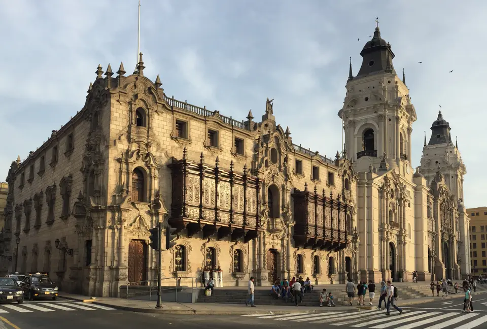
- Plaza de Armas and Plaza de la Vera Cruz: The foundational Plaza de Armas groups the Cathedral of Lima, the Sagrario Chapel, and the Archbishop's Palace alongside the seat of government, while the nearby Plaza de la Vera Cruz frames the Convent of Santo Domingo, where San Marcos University opened in 1553.
- Santiago Apostle reduction district in Cercado: Added in the 2023 boundary extension across 10.2 hectares within the Cercado district to preserve the Ancient Reduction of Santiago Apostle, an early walled indigenous settlement quarter established during the viceregal era.
- Quinta and Molino de Presa: Also added as an exclave in 2023 across 1.62 hectares north of the Rímac River in the Rímac district, safeguarding the 18th-century aristocratic suburban villa and watermill ensemble alongside the main 266.17-hectare Historic Centre zone.
The 1862 Jirón Street Naming System and 21st-Century Restoration
Until 1862, every individual street inside the formerly walled city was named separately block by block. Following a street-naming concept that Manuel Atanasio Fuentes first proposed in 1857, the municipality adopted the street-naming project of Mariano Bolognesi in 1862. South of the Rímac River, Union Street was selected as a central divisional axis for intersecting roads, which were renamed depending on whether they lay east or west of Union Street and connected as continuous thoroughfares under the title of jirón instead of the traditional calle. Under this system, jirones running parallel to the Rímac River were named after Peru's administrative departments, while perpendicular streets were named after provinces (with occasional exceptions named after rivers or prominent figures). Architectural historians such as Juan Bromley Seminario (author of Las viejas calles de Lima) and Enrique Bonilla Di Tolla later documented how these block-by-block colonial names preserved the social memory of guilds, convents, and viceregal families.
Legal protection began when Supreme Decree Nº 2900-72-ED protected the historic quarters of both Lima and Rímac as Monumental Zones on 28 December 1972 (expanded on 26 April 1989 by R.J. Nº 191-69-INC and unified in 1994 under Metropolitan Municipality of Lima Ordinance Nº 062-94-MML, followed by the first Master Plan applied from 1998 to 2010). In the 1980s, the Barrington textile firm funded custom street signs displaying traditional colonial names and descriptions, succeeding late-19th- and early-20th-century yellow plaques, some of which PROLIMA recovered in 2018 while restoring original façade colours. Between 2010 and its dissolution in 2022, Peruvian real estate company Arte Express acquired and restored numerous historic buildings, and for Peru's 2021 Bicentennial the municipality installed new yellow plaques, steel block numbers, and 206 QR video codes across major landmarks. To mark the 489th anniversary of the capital on 18 January 2024, President Dina Boluarte introduced a special restoration regime, followed on 17 January 2025 by the municipal relaunch of the Lima, Ciudad de los Reyes patronage programme and 2026 sanctions against political events that compromise the area's integrity.
Walking the Rímac Valley Plazas and Monumental Zones
A thorough walking itinerary links the major ensembles on both sides of the river. Begin at the Plaza de Armas to examine the Cathedral of Lima, the Sagrario Chapel, and the Archbishop's Palace while scanning the municipal QR plaques on building corners to learn each street's pre-1862 colonial name. Next, walk west to the Plaza de la Vera Cruz and the Convent of Santo Domingo, then follow the historic streets east toward the Rímac riverbank to tour the Convent of San Francisco before crossing into the Rímac district to visit the Quinta and Molino de Presa. You can view the Rímac Valley layout on the Atlas.
Take time on foot along the pedestrianised jirones to study the restored façade colours and black-and-white Blue Shield emblems, and check official church and convent portals in advance for current visiting schedules.
Walking block by block through the Cercado de Lima and across the river into the Rímac Monumental Zone highlights the layered urban history preserved within the 277.99-hectare World Heritage boundary. While the grand cloisters of the Convent of San Francisco and the Convent of Santo Domingo recall the centuries when religious orders organised the intellectual and artistic life of the Viceroyalty of Peru, the 1862 jirón street grid and the restored colonial block plaques trace how the republican capital modernized without erasing its viceregal foundations. With the 2023 addition of the Santiago Apostle reduction district in Cercado and the suburban villa and watermill of Quinta and Molino de Presa in Rímac, visitors can follow the full social spectrum of colonial Lima from the Plaza de Armas to its historic riverine outskirts.
