


























Quick Field Data
- UNESCO Inscription: 1983 (7th session; on the List of World Heritage in Danger from 1992 to 2005) · Criteria (vii), (viii), (ix), (x).
- Scale & Footprint: 5,177.65 square kilometres across the provinces of Morona-Santiago, Chimborazo, Tungurahua, Cañar, and Azuay, with 327 lakes covering 31.5 square kilometres.
- Access & Ticketing: Administered as an IUCN Category II national park established in 1979; check the official site for trail registration and volcanic safety updates before entering highland or cloud-forest sectors.
- Arrival Logistics: Reached from southern and central highland hubs including Cuenca in Azuay Province as well as trailheads in Chimborazo, Tungurahua, Cañar, and Morona-Santiago.
Three Volcanoes and the Altitudinal Gradient from Rainforest to Glacier
Spanning 5,177.65 square kilometres across five provinces of central and southern Ecuador, Morona-Santiago, Chimborazo, Tungurahua, Cañar, and Azuay, Sangay National Park (Parque Nacional Sangay) takes its name from the Shuar language word samkay, meaning volcano. Protected in Ecuador as a national park in 1979 and inscribed on the UNESCO World Heritage Atlas during the 7th session in 1983 under all four natural criteria, the reserve protects an unbroken vertical gradient stretching from 900 metres (2,953 feet) in the eastern tropical lowlands up to 5,319 metres (17,451 feet) above sea level along the snow-capped crest of the Andes. Because this rugged topography of deep steep-sided valleys and sheer cliffs alongside jagged rocky peaks has remained largely isolated from dense settlement, the park preserves the entire spectrum of eastern Andean ecosystems within a single continuous landscape.
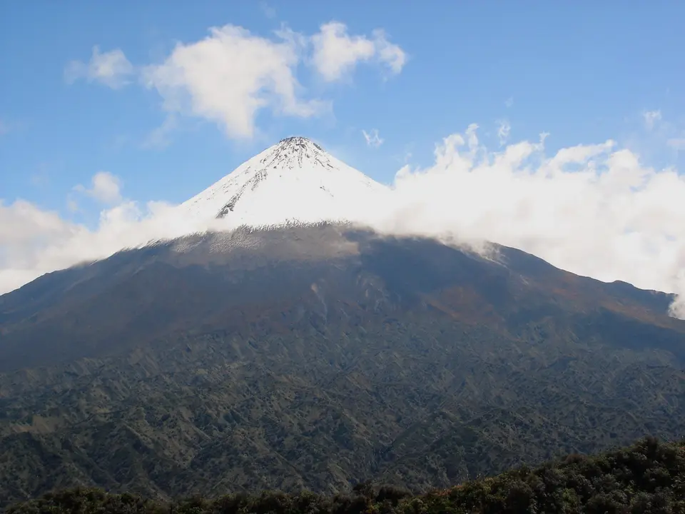
Three major volcanic edifices anchor the high mountain skyline. In the north rises the active cone of Tungurahua (5,016m), while the central cordillera is dominated by the active strato-volcano of Sangay (measured at 5,140m to 5,230m in altitude), recognised by geologists as one of the world's most persistently active volcanic cones. Completing the triad is the extinct glaciated volcano of El Altar, known in the indigenous tongue as Kapak Urku, which reaches the park's highest point at 5,319 metres. Across the upper slopes of these three peaks rise glaciers alongside barren volcanic ash fields that stand in sharp visual contrast to the lush montane cloud forests and Amazon Basin plains directly below.
Below the perpetual ice and rock crags extends one of the largest expanses of páramo, fragile high-elevation montane moorlands and grasslands, found anywhere in Ecuador. Fed by heavy rainfall and snowmelt across the high basins, a vast highland wetland system of 327 glacial lakes covers 31.5 square kilometres (12.2 square miles), regulating water supplies of local and national as well as regional importance. From these highland moorlands and lagoons, large rivers plunge eastward down steep gorges toward the Amazon Basin. Because rainfall is high and the mountain slopes are exceptionally steep, river run-off is rapid and water levels fluctuate dramatically after storms, though thick primary forest cover on the lower ridges helps control natural erosion.
This hydrological network links the glaciated volcanic summits directly to the western headwaters of the Amazon Basin. Across the upper basins of Morona-Santiago, Chimborazo, Tungurahua, Cañar, and Azuay, the 327 alpine lagoons and surrounding peatlands act as a natural sponge that captures heavy Andean precipitation before releasing it into steep mountain gorges. Whenever torrential rains sweep the eastern cordillera, the combination of sheer rock gradients and narrow valley walls produces fast, dramatic fluctuations in river volume. Without the dense canopy of montane cloud forest and lowland Amazon rainforest anchoring the thin volcanic soils along the lower slopes above the 900-metre lowland boundary, catastrophic landslides would strip the valley walls. By keeping both the high páramo moorlands and the lower forest belts within a single protected boundary of 5,177.65 square kilometres, Sangay National Park safeguards water supplies and ecological stability across local and national as well as regional scales.
Endemic Cloud-Forest Flora and Threatened Andean Fauna
The combination of fertile volcanic soils, extreme elevational variation between 900 and 5,319 metres, and minimal human alteration has allowed Sangay National Park to sustain an extraordinary concentration of native life. Botanical surveys have documented over 3,000 flowering plant species distributed across the park's glacial moraines, wet páramo moorlands, cloud forests, and lower tropical rainforests. As elevation drops from the windy tussock grasslands of the high passes into the perpetually mist-shrouded cloud forest, stunted montane shrubs give way to dense canopies laden with mosses, ferns and bromeliads, and epiphytes before merging into tall Amazon rainforest along the eastern plains.
Vertebrate inventories confirm at least 107 mammal species, more than 400 to 430 bird species, 33 amphibian species, 14 reptile species, and 17 fish species. Because of its remoteness, the park functions as a critical highland refuge for threatened Andean megafauna, specifically the endangered mountain tapir, for which Sangay represents a vital global stronghold, and the spectacled bear (researched in the park by the Fundación Cordillera Tropical). In the lower montane and tropical forests live the Brazilian tapir, giant otter, jaguar, cougar, ocelot, margay, pampas cat, white-tailed deer (subspecies Odocoileus virginianus ustus) alongside the northern pudu and the little red brocket deer.
Scientific exploration of the park's cloud forests and páramos continues to uncover species new to science. In 2013, zoologists described the Sangay shrew opossum (Caenolestes sangay) from specimens collected inside the park; in 2016, researchers identified a new cloud-forest frog in the genus Pristimantis (Pristimantis tinguichaca); and in 2026, taxonomists described a previously unknown arboreal porcupine belonging to the genus Coendou from specimens inside the reserve, alongside extensive lepidopteran studies such as Jean-Claude Petit's work on the butterflies of Sangay National Park. Designated an Important Bird Area by BirdLife International, the reserve shelters over 400 bird species, led by the Andean condor soaring above the crags of El Altar and Sangay and the vividly plumaged Andean cock-of-the-rock in the lower cloud-forest ravines.
Conservation Recovery and Planning Field Excursions from Cuenca
In 1992, UNESCO placed Sangay National Park on the List of World Heritage in Danger after illegal poaching, extensive livestock grazing in the fragile páramo, encroachment along the park perimeter, and unplanned road construction threatened the integrity of its ecosystems. Following thirteen years of strengthened boundary protection, grazing controls, and conservation management, the park was officially removed from the list of endangered sites in 2005. High winds sweep the moorlands. The recovery achieved between 1992 and 2005 demonstrated how halting unplanned road construction, curbing perimeter encroachment, and controlling livestock grazing in high-altitude grasslands could restore damaged Andean habitats. Because the mountain tapir and the spectacled bear require vast, unfragmented territories spanning multiple elevation zones from wet páramo down to cloud forest, the biological connectivity preserved linking Tungurahua (5,016m) with Sangay (5,140m to 5,230m) and El Altar (5,319m) remains essential to their survival. Ongoing field projects, ranging from the Spectacled Bear Research and Conservation Project led by the Fundación Cordillera Tropical to entomological surveys of Andean butterflies and amphibian inventories in the mist-filled ravines, continue to document species that exist nowhere else in Ecuador.
Today, visiting Sangay requires careful preparation for steep terrain and rapidly shifting mountain weather. Because the 5,177.65-square-kilometre territory spans five provinces from Azuay and Cañar in the south to Chimborazo, Tungurahua, and Morona-Santiago in the north and east, travellers choose specific access corridors depending on whether they wish to trek into glacial valleys, observe highland lagoons, or explore lower cloud-forest ridges. From the southern historic city of Cuenca, lying roughly 140 kilometres from the park's core sectors, road corridors lead northward through Azuay and Cañar toward the high moorland lagoons and eastward toward the forested valleys of Morona-Santiago, while northern approaches through Chimborazo and Tungurahua give hikers direct access to the glacial cirques of Kapak Urku (El Altar) and the volcanic slopes overlooking the eastern plains.
- Entry and Route: Travellers basing themselves in Cuenca in Azuay Province can travel north into Cañar and Chimborazo to reach high-altitude páramo trailheads and wetland lagoons, or follow eastern routes into Morona-Santiago to approach the lower cloud-forest slopes. Northern hiking routes toward the caldera of El Altar (Kapak Urku) and the flanks of Tungurahua start from the Chimborazo and Tungurahua highland valleys.
- Tickets and Viewpoints: Before departing for the trailheads, check the official site of the national park authorities in Ecuador before setting out to verify current volcanic activity alerts around Sangay and Tungurahua and to register at ranger checkpoints. Highland trails climb past peat bogs and glacial lakes toward viewpoints overlooking the 5,319-metre peaks, where binoculars help spot Andean condors, mountain tapirs, and spectacled bears.
- Timing and Onward Connections: Pack waterproof outer layers, insulated clothing for sub-zero highland nights, and sturdy boots capable of handling deep mud along the páramo paths, and never cross swollen eastern rivers during heavy rain when run-off rises rapidly. Pair your expedition into Sangay National Park with our destination guide to Cuenca and browse our UNESCO World Heritage Atlas for more Andean natural reserves.
