Quick Field Data
- UNESCO Inscription: 2007 (Ref. 1264), serial natural heritage reserve inscribed on 2 July 2007 across three volcanic zones; Criteria (vii) and (viii).
- Scale & Footprint: 9,521.8 hectares of core terrain (cited with associated protected zones totalling 18,846 hectares in UNESCO summaries). The reserve covers Hallasan Natural Reserve, Seongsan Ilchulbong, and the Geomunoreum lava tube system.
- Access & Ticketing: Hallasan summit paths and Seongsan Ilchulbong boardwalk stairs operate on seasonal daylight access windows, while subterranean cave entry inside Geomunoreum is regulated for conservation. Verify current trail passes and cave access rules on official Jeju provincial portals.
- Arrival Logistics: Direct commercial flights land at Jeju International Airport (CJU), 24 kilometres from the central volcanic zones. Located 82.8 kilometres south of the Korean Peninsula across the Korea Strait, the island also links by sea and air to Busan (287 kilometres).
Hotspot Volcanism Across Jeju Island South Korea
Measuring 73 kilometres east to west and 31 to 41 kilometres north to south, Jeju Island South Korea spans 1,833.2 square kilometres, representing 1.83 percent of national land area. Earlier historical records applied names including Doi, Dongyeongju, Juho, Tammora, Seomna, Tangna, Tamna, Junweonhado, Taekseungnido, Samdado, Sammudo, and European Quelpart (used until Cheju spelling changed on 7 July 2000). Portuguese mariners called it Ilha de Ladrones, Dutch vessels logged Quelpaert around 1642 to 1648, and 1655 atlases printed Fungma island. Today Jeju Island forms one of Earth's rare large shield volcanoes built over a hotspot beneath a stationary continental crust plate.
Geological evolution unfolded across four volcanic pulses starting roughly 2 million years ago during the Pleistocene. Around 1.2 million years ago, a seafloor magma chamber erupted steadily until volcanic rock surfaced roughly 700 thousand years ago. Following an eruptive pause of roughly 100 thousand years, coastal activity resumed around 300 thousand years ago, and major basalt and trachyte lava flows built Hallasan Mountain Jeju roughly 100 thousand years ago. Roughly 25 thousand years ago, flank vents produced about 360 parasitic scoria cones called oreum, including Yongnuni Oreum and Geum Oreum, plus 20 coastal tuff rings. Chronicles in the Goryeosa note an eruption in 1007 CE, while geological dating places the latest eruption at least 2,000 years ago, keeping Hallasan within the active 10,000-year volcanic category.
Covering roughly 12 percent of Jeju Island, or 224 square kilometres, fractured 'a'a lava terrain known locally as gotjawal resisted farming until the 21st century. Rainwater sinking directly through open cracks in these pristine forests recharges underground aquifers supplying Jeju's half a million residents, prompting scientists to compare gotjawal to an inland Ramsar-grade wetland even without formal designation. Long geographic separation from mainland Korea nurtured distinct vertical vegetation belts spanning coastal subtropical plants up to subalpine summits within the Yangtze-southwest Japan temperate floral zone. Jeju hosts over 4,000 Korean vascular plant species, roughly 400 rare taxa, 23 of South Korea's 59 designated wild plant species (six inside Hallasan's natural reserve), 50 special highland plants, 4,300 insect species, and 254 spider species concentrated heavily on northern slopes.
Animal life also mirrors island isolation, though lowland rodents face pesticides and six local tick species trouble livestock. Jeju records 364 bird species overall, comprising 91 passing migrants, 100 winter birds, 42 resident species, 43 vagrants, and 160 mountain species on Hallasan, including 19 designated as natural monuments and trailside ravens. After tigers, wild boars, and Formosan deer vanished, protected roe deer became Jeju's largest wild mammal, sharing uplands with weasels, badgers, and abundant highland amphibians and reptiles across marshy meadows. Long before modern conservation, the island also nurtured indigenous livestock breeds including Jeju Black cattle, Jeju Black pigs, and sturdy Jeju horses. Around the 258-kilometre shoreline, a 181-kilometre main ring road connects Gimnyeong Beach north, Songak Mountain south, Suwolbong west, and Seongsan Ilchulbong east. Culturally, Jeju preserves distinct indigenous heritage recognised through UNESCO attention to its critically endangered Jeju language and intact local shamanic customs.
Mount Hallasan, Seongsan Ilchulbong, and the Geomunoreum Tubes
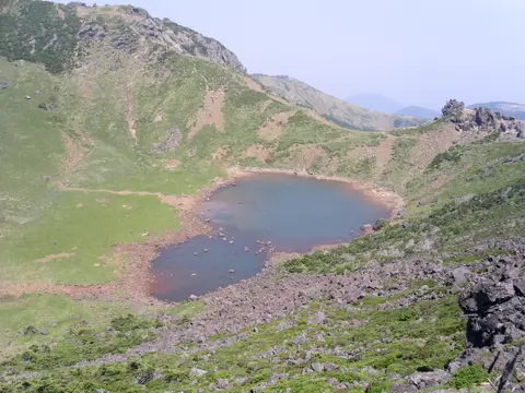
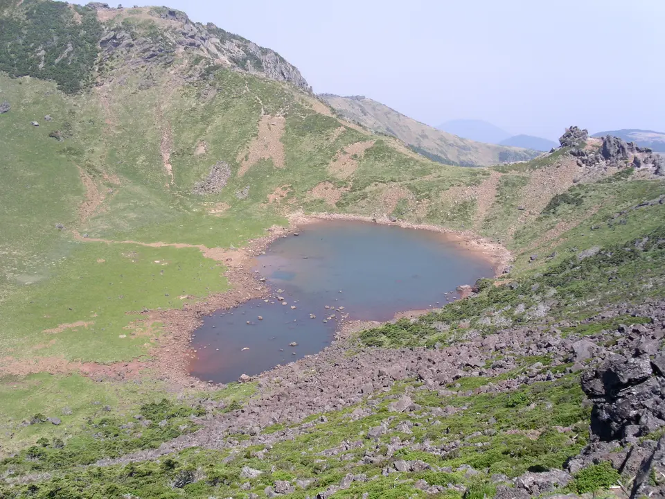
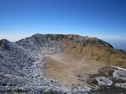
Rising at Jeju's centre, Mount Hallasan reaches 1,947 metres (often cited as 1,950 metres in geological surveys), making it South Korea's highest mountain. Protected since 12 October 1966 as Natural Monument number 182 inside Hallasan National Park, its volcanic ash, sand, and lapilli slopes give South Korea's highest soil organic content and fastest drainage despite low natural fertility. In local tradition Hallasan carried older Korean names including Hanla, Mount Auckland, Yeongjusan, and Wonsan, while hosting Gwaneumsa, Jeju's oldest Buddhist temple originally built between 1046 and 1083 under King Munjong. Crowning the summit lies a 400-metre volcanic pit housing Baengnokdam (White Deer Lake), stretching up to 2 kilometres around and 100 metres deep where western trachyte domes face eastern basalt beds 2 to 5 metres thick above clastic Tamna Formation sediments tilted at 1,580 metres.
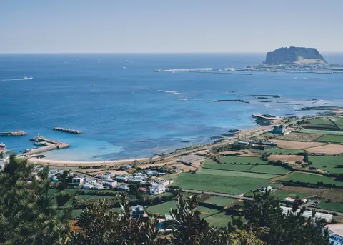
On Jeju's eastern headland rises Seongsan Ilchulbong, pairing two older names meaning Fortress Mountain and Sunrise Peak (with elderly locals still using Cheongsan). Erupting around 6,700 years ago via explosive Surtseyan hydrovolcanic activity across a shallow seabed, magma shifted west after clogging an earlier 600-metre crater identified 600 metres east in a 2021 study. Waves carved away outer ash slopes, exposing layered internal tuff beds along fortress-like sea cliffs before coastal sand joined the former island to Jeju. Standing 182 metres tall and 600 metres wide, its 2.64-square-kilometre grassy crater rests 90 metres above sea level and hosts 240 plant taxa. Declared a Natural Monument on 19 July 2000 and a Global Geopark site in October 2010, Seongsan formerly hosted Mongol-era Goryeo horse ranches nearby and 20th-century farming and bamboo plots inside the crater before environmental protection. Between 1910 and 1945, the Imperial Japanese Navy also dug around 18 wartime cliff tunnels here to conceal explosive boats. Today these wartime coastal cavities hold Registered Cultural Heritage status in South Korea. Volcanologists also study Seongsan's cross-sections closely because shifting magma vents and ocean erosion turned the tuff cone into a clear field laboratory for Surtseyan marine eruptions.
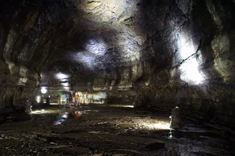
Between inland slopes and the northeast coast winds the Geomunoreum lava tube system, widely ranked among geologists as the finest lava cave series on Earth. Formed as molten basalt streams drained out beneath cooled rock crusts, passages including Manjanggul and Gimnyeonggul wind kilometres underground. What makes the Jeju lava tubes Manjanggul complex exceptionally rare is abundant secondary carbonate speleothems. While typical basalt tubes stay bare black rock, rainwater percolating through windblown surface shell sand dissolved calcium carbonate and built multi-coloured stalactites, floor crusts, and carbonate murals across dark lava walls.
Safeguarding delicate subterranean caves and grassy volcanic craters demands steady visitor management under Jeju's 2006-to-2010 and updated heritage plans, supported by scientific studies on possible future site extensions. Seongsan Ilchulbong drew 2.45 million visitors in 2011 and 1,427,941 visitors in 2022, concentrating foot traffic along its steep wooden stair deck while nearby boats also offer coastal views past Udo Island. Meanwhile, controlling agricultural runoff over buried cave roofs remains vital to protect underground groundwater quality and delicate speleothem surfaces.
Coastal Microclimates and Things to Do Jeju Island
Hallasan shapes sharp weather zones across Jeju Island Korea within its humid subtropical Cfa climate belt. In winter, northwesterly winds chill northern Jeju City (along with the Chuja Islands north of the main island) while Hallasan shields southern Seogwipo, giving downtown Seogwipo South Korea's warmest January averages. Under light sea breezes of 4 to 9 metres per second, morning inversion layers and thermal eddies warm mid-mountain flanks 1 to 3 degrees Celsius above coastal lows, rising by 4 degrees Celsius on sheltered leeward slopes. At night, chilled summit air drains downhill to drop downwind valley temperatures by 2 to 5 degrees Celsius, while rare winter cold waves such as January 2016 cancelled 1,200 flights and stranded 90,300 travellers.
Rainfall splits cleanly across the shield volcano from west to east. Western Gosan-ri logs Jeju's lowest annual rainfall distributed evenly throughout the calendar. Conversely, southeastern Seongsan-eup sits squarely in the path of East Asian monsoons and the warm Tsushima Current, giving Seogwipo and highland ridges Korea's heaviest precipitation, while March-to-May spring brings wide daily temperature swings.
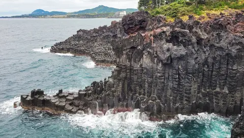
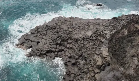
Travellers choosing things to do on Jeju Island South Korea combine highland craters with striking coastal geology. Along the south coast, Daepo Jusangjeolli exposes tightly packed hexagonal basalt columns where molten lava met ocean surf. Elsewhere, coastal Jeju Olle walking paths link fishing harbours past tuff rings, while Seongsan Ilchulbong's wooden stairs reach the crater rim in roughly 30 minutes before hosting the annual New Year Sunrise Festival with parades, trail walks, shamanic gut rituals, and lit fishing boats.
Access Zones Across Jeju's Volcanic Heritage Sites
Grouping excursions around Hallasan's central slopes, northeastern lava tubes, and the eastern tuff headland cuts cross-island driving along the 181-kilometre perimeter highway.
| Complex Zone | Key Highlights | Access & Ticket Rule |
|---|---|---|
| Hallasan National Park. | 1,947-metre summit, Baengnokdam crater lake, trachyte domes, oreum cones, and Gwaneumsa temple. | Trail corridors operate on seasonal daylight access schedules. Check official national park pages for permit and weather rules. |
| Seongsan Ilchulbong (Sunrise Peak). | 182-metre Surtseyan tuff cone, 30-minute deck stair climb, 600-metre crater bowl, and coastal wartime cliff caves. | Open from before sunrise until evening under seasonal rules. Park gates manage ticketing and New Year Sunrise Festival access. |
| Geomunoreum & Manjanggul Tubes. | Extensive basalt lava caves, multi-coloured carbonate stalactites, and porous gotjawal volcanic forest trails. | Strict conservation caps protect cave humidity. Check current tunnel access and guided slots at Jeju World Natural Heritage Centre. |
| Southern Basalt Coast (Daepo). | Columnar-jointed Daepo Jusangjeolli cliffs, milder Seogwipo winter air, and coastal Jeju Olle walking tracks. | Boardwalk viewpoints stay accessible year-round during daytime park schedules with local gate entry tickets. |
Three Geological Features Across Jeju's Volcanic Terrain
- Carbonate Speleothems Over Basalt Walls: Inside accessible segments of the Geomunoreum network, inspect pale and multi-coloured limestone stalactites hanging from black volcanic ceilings. Windblown coastal shell sand supplied dissolved calcium carbonate that dripped down through fractured lava roofs.
- Surtseyan Ash Beds at Seongsan Ilchulbong: Study the ocean-cut cliffs flanking Sunrise Peak to read angled layers of bedded volcanic tuff. Wave erosion sliced open the cone's interior, revealing how magma exploded violently through shallow coastal water 6,700 years ago.
- Porous Gotjawal Lava Aquifers: Walking shaded trails over fractured 'a'a lava blocks, observe mosses, ferns, and evergreen roots clinging straight to bare black stone. Open cracks allow monsoon rainfall to sink directly underground, feeding freshwater wells across Jeju Island.
How to Get to Jeju Island and Best Time to Visit
Knowing how to get to Jeju Island centres on direct domestic and regional flights into Jeju International Airport (CJU), sitting 24 kilometres from the main volcanic zone. Lying 82.8 kilometres off the southern peninsula, the island also connects via air and ferry routes with our Busan destination guide (287 kilometres northeast). Deciding the best time to visit Jeju Island matches seasons cleanly to outdoor priorities. Spring offers blossoms amid brisk upland swings, while crisp autumn clears clouds around Hallasan's 1,947-metre summit, and warm summer seas provide the best time to visit Jeju Island for swimming.
Plan three to four days to pair Seongsan Ilchulbong and the Geomunoreum lava tubes with a full Hallasan summit hike and southern basalt headland walks. Checking trail status and cave openings ahead of departure ensures safe highland climbing under shifting maritime winds. For additional volcanic landscapes and natural reserves across Asia, explore our UNESCO World Heritage Atlas.