Quick Field Data
- UNESCO Inscription: Reference 857, inscribed in 1998 as a Cultural World Heritage Site under criteria (ii) and (iv).
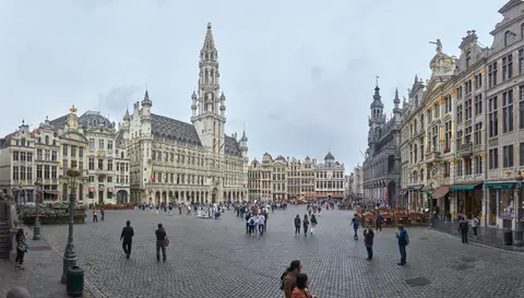
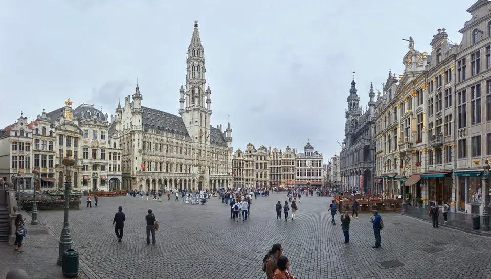
- Scale & Footprint: Occupies 1.48 hectares centred on a paved rectangular square measuring 68 by 110 metres, surrounded by a buffer zone of 26 densely built historic Lower Town islands containing more than 150 protected buildings.
- Access & Ticketing: The cobbled pedestrian square and exterior guildhall façades remain permanently open-access; entry into the Brussels City Museum inside the King's House, scheduled tours of the Town Hall, and private trade museums such as the Brewers' Museum or Choco-Story require admission tickets. Check official Brussels municipal portals for visiting conditions.
- Arrival Logistics: Brussels Airport (BRU) sits 11 km northeast of the city centre, backed by Brussels South Charleroi Airport (CRL, 43 km south) and Eindhoven Airport (EIN, 98 km northeast). The square forms the historic heart of our Brussels destination guide (0 km).
From Lower Market Marsh to Civic and Ducal Rivalry
Brussels began along the River Senne in the tenth century when Charles, Duke of Lower Lorraine, raised a fort on Saint-Géry Island at the furthest navigable inland point of the river. Near that fort and beside sandbanks bordering a drained marsh, merchants laid out an open-air trading ground by the late eleventh century. It stood along the Steenwegh trade corridor connecting the Rhineland and the County of Flanders. A 1174 charter records this trading square as the forum inferius, or Nedermerckt ("Lower Market" in Old Dutch), set near St Nicholas' Church and the river port. By the early thirteenth century the Duke of Brabant erected three covered markets along the northern edge for meat, bread, and cloth, both to shelter goods and to monitor sales for tax collection. Timber-and-thatch structures stood beside stone patrician residences called steenen, whose memory survives in surrounding street names such as Plattesteen, Cantersteen, and Rue des Pierres/Steenstraat. A stone fountain installed in 1302 replaced an earlier spring with eight water jets and eight basins before the bread hall.
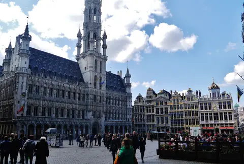
Over the fourteenth century, cash-strapped dukes gradually ceded control over mills and trade rights to Brussels merchants, letting municipal leaders reshape the square. In 1353 the city ordered a large indoor cloth market (Halle au Drap) resembling those of Mechelen and Leuven on the south flank, expropriating irregular gardens and structures that had cluttered the plaza. Between 1401 and 1455 Brussels erected its monumental Town Hall (Hôtel de Ville / Stadhuis) on the south side, turning the market into the seat of civic power. The eastern wing began between 1401 and 1421 under Jacob van Thienen and Jean Bornoy. Young Charles the Bold laid the first stone of the western wing in 1444, often linked to city architect Willem de Voghel, designer of the Aula Magna at Coudenberg in 1452. Philip the Good's court architect Jan van Ruysbroek raised the 96-metre Brabantine Gothic spire, topped in 1455 by Maarten Van Rode's 2.7-metre gilt statue of Saint Michael slaying a demon.
Counterbalancing municipal power, the Duke of Brabant ordered a Flamboyant Gothic administrative building directly across the square between 1504 and 1536 atop the old bread and cloth market footprint. Known initially as the Duke's House ('s Hertogenhuys) and later the King's House (Maison du Roi) after the ruler inherited the Spanish throne, it retained the Dutch name Broodhuis ("Bread House"). Rebuilt later in the sixteenth century under Emperor Charles V's architect Antoon II Keldermans without towers or galleries, the building framed tragic public executions. Protestant martyrs Jan van Essen and Hendrik Vos burned here in 1523, before Counts Lamoral of Egmont and Philip de Montmorency of Horn were beheaded in front of the King's House in 1568. Their executions sparked the Dutch Revolt led by William of Orange, and in 1719 guild dean François Anneessens died on the square for defending traditional craft privileges against Austrian Habsburg reforms.
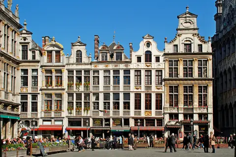
The 1695 French Bombardment and the Four-Year Guild Reconstruction
On 13 August 1695, during the Nine Years' War, a 70,000-strong French army commanded by Marshal François de Neufville, duc de Villeroy, bombarded central Brussels for three days with cannons and incendiary mortars. The assault sought to draw Allied forces away from the siege of Namur, sparking fires that swept through the timbered medieval core and flattened most of the Grand-Place. Ironically, although French artillery aimed directly at the 96-metre spire of the Town Hall, its stone shell, tower, and scattered masonry walls remained standing amidst blackened rubble.
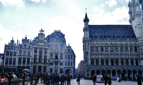
What followed defined Brussels' urban identity. Rather than replacing medieval lanes with a single uniform Baroque plaza, the City Magistrate and Governor required Brussels' wealthy craft guilds and private owners to rebuild their houses within just four years. Working along corrected alignments, owners had to submit every façade drawing for municipal approval under threat of fines. This strict civic supervision produced rare coherence across apparently contrasting Gothic, Baroque, and Louis XIV elevations. Each guildhouse carried a symbolic house name and gilded trade emblems on stone gables rising from the square. Together they formed an open-air display of corporate status around a marketplace completely free of any church or religious house.
Turbulence returned at the end of the eighteenth century when French revolutionaries sacked noble statues and Christian emblems and abolished the guilds in 1795. They renamed the plaza Square of the People with a Liberty tree and sold guildhall archives and furniture at public auction in 1796. Skirmishes flared here again during Belgian independence in 1830, when the square briefly bore the name Square of Regency. Later in the century, Victor Hugo lodged inside Le Pigeon (De Duif) in 1852 and Charles Baudelaire lectured at the King's House in the 1860s. The Belgian Workers' Party was founded here in 1885 near the city where Karl Marx had written The Communist Manifesto in 1848.
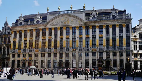
Brabant Gothic, Gilded Gables, and Nineteenth-Century Conservation
By the mid-nineteenth century, pollution, painted stucco alterations, and traffic pressure threatened the historic square. In 1853, demolition of the L'Étoile (De Sterre) guildhall widened the street beside the Town Hall for a horse-drawn tramway. That loss catalysed a conservation campaign led by Mayor Charles Buls from 1840 and intensified through the late nineteenth century. Guided by historical records and especially F. J. Rons's 1737 engravings, architects restored weathered Gobertange calcareous sandstone and Euville stone façades, carved woodwork, and guild statuary. Between 1874 and 1896, architect Victor Jamaer (a pupil of Eugène Viollet-le-Duc) completely reconstructed the King's House in neo-Gothic form after earlier 1695 and 1767 repairs. Original fifteenth-century Town Hall façade statues and Maarten Van Rode's original 1455 Saint Michael weathervane were transferred inside the Brussels City Museum for safekeeping. A copy replaced the original weathervane atop the spire in the 1990s.
Monuments installed on the cobbles shifted with civic tastes, starting with an 1856 fountain marking the twenty-fifth regnal year of King Leopold the First. That fountain gave way in 1864 to a monument for Egmont and Horn (later moved to Petit Sablon) and a Belle Époque bandstand three decades later. In the twentieth century, Brussels Town Hall served as a makeshift hospital at the outbreak of the First World War. That role ended when occupying German forces arrived on 20 August 1914 and hoisted their flag beside the portal. Daily wholesale food trading persisted on the Grote Markt until 19 November 1959, commemorated today in surrounding street names tied to butter, cheese, herring, and coal sellers.
Car parking filled the square during the 1960s until citizen protests cleared parked cars in 1972; through traffic continued until a September 1990 pedestrianisation trial became permanent on 1 January 1991. The square also survived repairs after a 1979 IRA bombing under an outdoor concert stage that injured 15 people including four British Army musicians. La Grand-Place now sits inside a carefully guarded buffer zone known as the "sacred island". This perimeter contains mid-nineteenth-century landmarks like Cluysenaar's Galeries Royales Saint-Hubert (1847) and Galerie Bortier (1848), L. P. Suys's Stock Exchange, and the 1870 Senne vaulting works. Managed under the Brussels Spatial Planning Code (COBAT) and the city's dedicated Management Plan, more than 150 protected buffer-zone structures now undergo coordinated façade conservation against commercial and tourist wear.
Square Perimeter, Museums, and Buffer Zone Access
Visitors can walk freely across the entire 68-by-110-metre paved square at any hour while choosing selectively among interior museum buildings, restored council rooms, and protected surrounding arcades.
| Complex Zone | Key Highlights | Access & Ticket Rule |
|---|---|---|
| Brussels Town Hall (Hôtel de Ville) | 1401 to 1455 Brabant Gothic wings, 96-metre Jan van Ruysbroek spire, Maximilian and States of Brabant rooms | Courtyard and exterior portico are open to view; interior neo-Gothic halls require booked guided tickets. Check the official municipal site. |
| King's House (Maison du Roi / Broodhuis) | Victor Jamaer's 1874 to 1896 neo-Gothic façade housing the Brussels City Museum and original 1455 sculptures | Exterior arcades face the open square; museum entry operates via standard admission tickets. Check official schedule before visiting. |
| Baroque Guildhalls (Perimeter Rings) | Late 17th-century guild fronts such as Maison des Ducs de Brabant, Le Pigeon, Brewers' House, and L'Étoile corner | Ground floors host shops, chocolatiers, and brasseries open during business hours; the Brewers' Museum inside requires a museum ticket. |
| Sacred Island Buffer Zone & Arcades | Galeries Royales Saint-Hubert (1847), Brussels Stock Exchange, Choco-Story on Rue de la Tête d'Or, market lanes | Covered shopping galleries and surrounding pedestrian streets are permanently open-access; private specialty museums charge separate entry. |
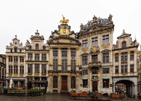
Facade Asymmetry, Guild Emblems, and Sandstone Restoration Details
Standing on the central cobbles lets you test three telling architectural clues hidden inside the seemingly symmetrical square.
- The Off-Centre Town Hall Spire: Look closely at the south façade of the Hôtel de Ville. The 96-metre octagonal openwork tower does not sit exactly midway between the 1401 east wing and the 1444 west wing, and their arcade arches differ slightly in count and width. Contrary to folklore claiming a legendary architect's fatal blunder, builders incorporated an existing belfry footprint and adapted to tight medieval plot lines. Inside, later restorations shaped the Maximilian Room (hung with tapestries depicting the life of Clovis) and the States of Brabant council room. They also shaped the Gothic Room and the former courtroom known as the Wedding Room.
- Soot-Resistant Stone Replacement Blocks: Along the upper guildhouse gables and the King's House, look for subtle pale tonal shifts between historic Gobertange calcareous sandstone and replacement Euville limestone blocks. These blocks were inserted during nineteenth- and late-twentieth-century conservation campaigns guided by 1737 engravings, backed by regional building subsidies that preserve authentic interiors.
- Gilded Corporate Trade Symbols: Scan the sculpted pediments and bracket reliefs on the rebuilt post-1695 guildhalls, spotting gilded ships, wheelbarrows, swans, foxes, and brewers' emblems that signalled each corporation's legal seat even before literacy became widespread.
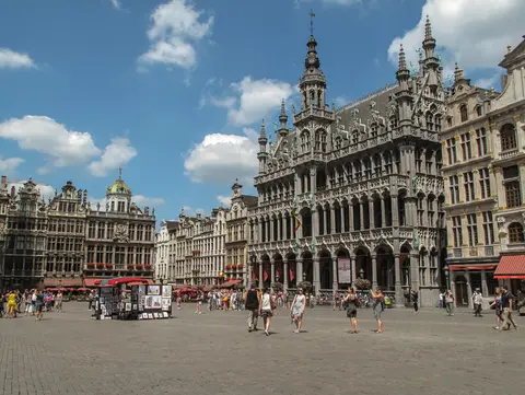
Timing the Square and Navigating Central Brussels
Early morning delivers clear photographs across the 68-by-110-metre cobbles without tour groups blocking the Town Hall portico, whereas evening brings architectural lighting across gilded Baroque gables. In August of every even-numbered year, artisans lay an enormous temporary flower carpet across the centre of the square, while winter brings an annual Christmas tree tradition dating back to the mid-twentieth century. Brussels Airport (BRU) sits 11 km northeast, while Charleroi (43 km) and Eindhoven (98 km) connect via direct regional links. Arriving travellers can walk straight from Central Station into the pedestrian core without vehicles, taking time to explore nearby streets named for medieval butter, cheese, herring, and coal trades.
Continue exploring surrounding Brussels districts, covered arcades, and beer museums in our Brussels city guide, and compare historic European civic squares across our UNESCO World Heritage Atlas.