Quick Field Data
- UNESCO Inscription: Ref. 700 · Cultural Site · Inscribed 1994 · Criteria (i), (iii), (iv)
- Scale & Footprint: Protected reserve of 75,358.47 hectares across the Rio Grande de Nasca basin and Pampas de Jumana, with over 1,300 kilometres of combined lines spanning roughly 450 square kilometres
- Access & Ticketing: Managed by the Peruvian Ministry of Culture under Law No. 28296 and Resolution 421/INC; ground entry onto the desert pavement is strictly prohibited, while viewing towers along the PE-1S highway and scenic overflights require official entry fees and permits checked through the official Ministry of Culture site
- Arrival Logistics: Roughly 400 kilometres south of Lima along the Panamericana Sur (PE-1S), 25 kilometres from Maria Reiche Neuman Airport (NZC) near Nazca town
Geoglyph Construction on the Pampas de Jumana
Stretching more than 80 kilometres between the desert towns of Nazca and Palpa in southern Peru, the Pampas de Jumana occupies an arid Pleistocene alluvial terrace within the Rio Grande de Nasca river basin. The densest concentration of earthworks fills a 10 by 4 kilometre rectangle south of the hamlet of San Miguel de la Pascana, flanking the modern PE-1S Panamericana Sur corridor some 400 kilometres south of Lima. While the full protected archaeological reserve spans 75,358.47 hectares and wider survey polygons encompass roughly 450 square kilometres, individual concentrations of densely packed figures occupy core zones around 50 square kilometres in extent. Despite popular assumptions that these figures required monumental excavation or aerial guidance, archaeological fieldwork and experimental replication demonstrate a strikingly economical construction method tailored to local desert geology.
The plateau surface is carpeted by a dark, reddish-brown layer of small weathered pebbles coated in ferric oxide varnish. Pre-Hispanic builders cleared away this thin rocky veneer to cut shallow trenches measuring 10 to 15 centimetres deep, exposing the pale, yellow-grey clay subsoil beneath. Because the underlying clay contains high proportions of lime, morning desert mist moistens the freshly exposed trench floor, which then dries into a hardened protective crust. That natural mineral seal shields the exposed clay against wind erosion, while the windless, hyper-arid climate of the Peruvian coastal plain limits water runoff to occasional El Nino Southern Oscillation (ENSO) rainfall events.
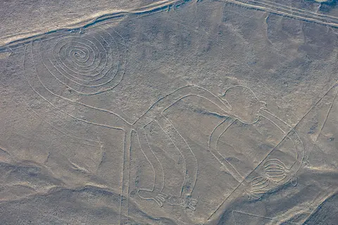
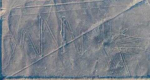
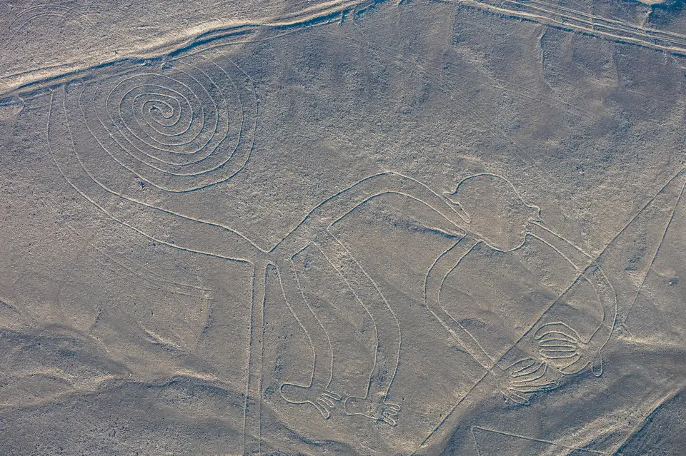
Dimensional measurements clarify the precision of this subtractive surface technique. The combined length of all documented linear features exceeds 1,300 kilometres. More than half of the linear trenches measure slightly over 33 centimetres in width, though narrow single paths drop to 30 centimetres and broader cleared bands reach 1.8 metres across. Many representational shapes were executed as one continuous, uninterrupted trench line. Individual zoomorphic and botanical motifs attain massive footprints: the spider measures 47 metres across, the monkey spans 93 by 58 metres, the hummingbird stretches 93 metres in length and the condor reaches 134 metres. Meanwhile, the largest straight geometric sweeps extend up to 370 metres or even several kilometres across the pampas.
Wooden stakes preserved in the desert soil at line endpoints confirm how small survey teams transferred scaled sketches onto the open plain. Radiocarbon testing on a recovered wooden stake provided direct chronological dating for the complex. In the early twenty-first century, American investigator Joe Nickell tested this engineering model directly on the ground using simple wooden stakes, cords, and sighting tools available to pre-Hispanic builders, reproducing full-scale Nazca figures in days without aerial assistance. Scientific commentators noted the exactness of Nickell's reconstruction, which dismantled Erich von Daniken's 1968 bestseller claim of ancient astronaut landing strips and reaffirmed indigenous Andean surveying skill.
From Paracas Hillslopes to Nasca Ceremonial Tracks
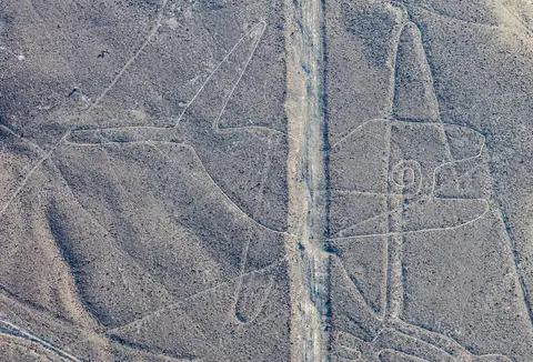
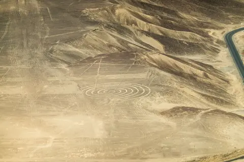
Archaeological stratigraphy divides the geoglyph tradition into two broad developmental phases spanning roughly 500 BC to AD 500. Both sit within a wider cultural sequence reaching from the 8th century BC to the 8th century AD across Middle and Late Formative through Regional Development periods. During the earlier Paracas phase (400 to 200 BC), communities frequently carved smaller, solid-surface relief figures onto sloping hillsides in the Palpa sector so viewers standing along valley trails could read them directly from ground level. During the subsequent Nasca phase (200 BC to AD 500), makers expanded onto the flat alluvial terraces of the Pampas de Jumana. They favoured continuous line-type outlines, vast triangles, spirals, rectangles, wavy lines, radiating promontory centres, and wide cleared tracks built to accommodate large groups of people.
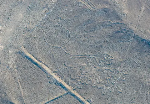
Systematic fieldwork conducted since 1996 by Markus Reindel and Johny Cuadrado Isla documented and excavated more than 650 sites across the basin. Comparing geoglyph motifs directly against regional ceramic iconography led them to place key figurative works between 600 and 200 BC. Representational glyphs lean heavily toward non-human forms: researchers record more than 70 zoomorphic designs, including a hummingbird, condor, heron, parrot, monkey, spider, dog, cat, fish, lizard, and whale, plus stylised plants, trees, flowers, everyday objects, and comparatively scarce anthropomorphic figures. Birds appear more frequently than any other animal group, and a 2019 multi-disciplinary study highlighted in Smithsonian reports found that several avian glyphs depict non-desert exotic birds rather than indigenous coastal species.
Scholarly debates over why Paracas and Nasca societies invested generations of communal labour into these shallow trenches have moved far beyond early single-function hypotheses. American historian Paul Kosok, arriving in 1940 to 1941 to study ancient irrigation canals, flew over the pampas and recognised a bird outline with lines converging on the Southern Hemisphere winter solstice horizon. Joined by Richard P. Schaedel and German mathematician Maria Reiche (who dedicated decades from 1941 onward to surveying and cleaning the glyphs), Kosok proposed that the figures functioned as an astronomical horizon observatory and constellation map. Later statistical archaeoastronomy tests by Gerald Hawkins and Anthony Aveni in 1990 concluded that alignment evidence was insufficient to support a universal astronomical model, and Aveni subsequently critiqued Adler Planetarium astronomer Phyllis B. Pitluga's 1998 proposal linking the giant spider to Orion and Milky Way dark patches for overlooking 12 other connected lines.
Alternative cultural and hydrological interpretations rest on firmer archaeological ground. Swiss art historian Henri Stierlin proposed in 1983 that long trapezes functioned as giant looms for fabricating Paracas mummy-wrapping textiles, a hypothesis most archaeologists reject despite shared artistic patterns across ceramics, cloth, and ground drawings. Far broader consensus surrounds water rituals and ceremonial processions. In 1985, archaeologist Johan Reinhard linked the lines to Andean reverence for mountain and water deities controlling agricultural survival. He interpreted straight paths as sacred walkways leading to worship shrines and animal glyphs as invocations for rain. Geophysical fault surveys by David Johnson linked certain geoglyphs to subterranean aquifers tapped by ancient puquio aqueducts. Earlier, in 1977, Alberto Rossel Castro classified the network into three groups: field and irrigation tracks, mound-linked axes, and astronomical alignments. On the Pampa de Atarco, 10 kilometres south of Pampa de Nasca, satellite and drone sensing by Nicola Masini and Giuseppe Orefici revealed five geoglyph groups. These clusters linked spatially and ritually to the mudbrick temples of Cahuachi, including winter solstice and equinox radial centres used by pilgrims.
Field Surveys, Carbon Dating, and AI Discoveries
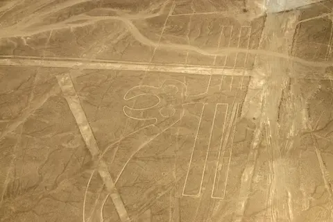
Written European records of the desert markings begin early in the colonial era. Spanish conquistador Pedro Cieza de Leon described them as trail markers in his 1553 chronicle, and in 1569 Spanish magistrate Luis Monzon recorded ancient road remains across the southern coastal plain. Although segments remained partially visible from surrounding foothills, twentieth-century awareness surged only after Peruvian military and civilian pilots crossed the pampas, prompting Peruvian archaeologist Toribio Mejia Xesspe to document lines on foot in 1927 and present his study at a 1939 conference in Lima.
Recent remote-sensing initiatives have transformed the known archaeological map. Beginning fieldwork in 2006, a Japanese team from Yamagata University identified two early small figures by 2011 (a human-head motif and an animal) and expanded its total to roughly 100 new geoglyphs by 2012. The university then opened a dedicated research centre in Nazca in September 2012 under a 15-year study programme. By 2019, Yamagata University and IBM Japan announced 143 newly discovered geoglyphs across the Nazca Pampa and surrounding terrain, including the first candidate pinpointed by machine learning. In 2020, targeted photographic conservation work on a steep, erosion-prone hillside revealed a previously overlooked feline figure. By 2022, the confirmed corpus stood at 358 known geoglyphs.
In 2024, researchers from Yamagata University's Nazca Institute and IBM Research dramatically expanded that count through deep neural network screening paired with exhaustive walking surveys. Between September 2022 and February 2023, screeners spent 1,200 labour hours reviewing artificial intelligence outputs to rank 1,309 high-potential candidates into three priority tiers. Surveyors followed this with 1,440 labour hours of authorised on-foot ground verification under Peruvian Ministry of Culture permits. That campaign confirmed 303 previously unknown figurative geoglyphs depicting parrots, cats, monkeys, killer whales, and severed heads. Comparing spatial layout against footpath proximity, the 2024 research team divided figurative works into two distinct classes. Larger line-type wild-animal figures functioned as planned public pilgrimage architecture, whereas smaller relief-type motifs (roughly half the length of line-types) showed humans, livestock, and sacrifice scenes placed visibly beside everyday walking trails.
Preservation across this vast open desert relies on strict legal frameworks backed by physical monitoring. Protected under Article 36 of the Peruvian Constitution, General Law for National Cultural Heritage No. 28296, and Resolution No. 421/INC establishing the Archaeological Reserve, the complex falls under the Peruvian Ministry of Culture and its comprehensive management plan covering Nasca and Palpa provinces. While minimal rainfall preserves trench crusts naturally, human pressures have left clear scars: the South Pan-American Highway slices straight across several lines and figures, and reports since 2012 flagged deteriorating sections caused by squatter settlement growth on reserve margins. Authorities continue refining field boundary maps to align legal protection zones with the actual geographic spread of newly verified geoglyphs.
Access Zones Across Nasca and Palpa
Because unescorted footsteps break the fragile ferric pebble surface and lime crust immediately, visitor movement is strictly confined to roadside elevated platforms, museum collections, and regulated air corridors.
| Complex Zone | Key Highlights | Access & Ticket Rule |
|---|---|---|
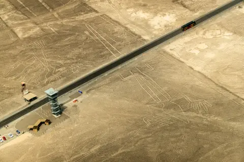
| Pan-American Highway Viewing Tower | Metal roadside platform along PE-1S overlooking the Tree, Hands, and adjacent Lizard severed by tarmac | Open to ticketed visitors under Ministry of Culture rules; check official site guidance for current tower fees and entry limits |
| Aerial Overflight Corridor (from NZC) | Elevated viewing near 500 metres altitude above the Hummingbird, Monkey, Condor, Spider, Heron, Whale, and Parrot | Light-aircraft flights operate out of Maria Reiche Neuman Airport; boarding requires passenger identification and official reserve fees |
| Palpa Foothills & Slope Terraces | Early Paracas-phase relief figures carved onto hillside slopes facing ancient valley walking trails | Observed strictly from designated hillside miradors and roadside viewpoints outside fenced reserve zones |
| Pampa de Atarco & Inner Pampas Reserve | Radial ceremonial centres, meandering motifs, wide ritual tracks, and 303 newly verified AI-survey geoglyphs | Closed to general tourism; physical foot entry is granted solely for permitted Ministry of Culture archaeological expeditions |
Reading Trenches, Stakes, and Horizon Lines on Site
Whether looking down from the PE-1S viewing tower or banking at roughly 500 metres above the plateau, three physical features clarify how these earthworks interact with desert terrain.
- Contrast Between Ferric Pavement and Lime Subsoil: Even from the roadside Mirador tower, notice how sharply the pale yellow-grey trench bottoms stand out against the dark reddish-brown surface pebbles. Morning coastal mist supplies just enough moisture to bind the exposed lime-rich clay into a thin natural mortar, explaining why shallow cuts only 10 to 15 centimetres deep survived more than two millennia of desert air.
- The Highway Cut Across the Lizard: Directly beneath the Panamericana Sur viewing tower, the asphalt roadbed severs the tail of the Lizard figure. Inspecting that intersection shows both the razor flatness of the Pleistocene alluvial terrace and why modern heritage regulations prohibit foot traffic or unescorted vehicles across the reserve.
- Line-Type vs Relief-Type Placement: Compare sweeping continuous-line animal outlines on the flat Pampas de Jumana against solid-cleared Paracas figures carved into sloping hills around Palpa. Flat-plain designs demanded elevated viewpoints or collective walking processions along wide tracks, whereas hillside relief scenes faced outward toward valley paths for immediate ground-level reading.
Schedule flights and highway stops for early morning before thermal desert winds reduce air clarity over the plateau, and pair southern coastal Peru with Andean stone cities via our Machu Picchu travel guide or explore additional heritage landscapes in the UNESCO World Heritage Atlas.