


























Quick Field Data
- UNESCO Inscription: 1983, with buffer zone extension in 2016 (Criteria i, iv; 18th-century Enlightenment urban planning uniting royal representation with public civic spaces).
- Scale & Footprint: Covers a 7-hectare core architectural zone surrounded by a 159-hectare urban buffer zone across the historic axis of Nancy in Lorraine, Grand Est, France.
- Access & Ticketing: All three interconnected pedestrian squares are open public thoroughfares; admission fees apply only to the interior collections of the Fine Arts Museum and Opera house, so check the official site.
- Arrival Logistics: Situated in central Nancy in the Grand Est region of France, within easy walking distance of the city railway hub and reachable on regional routes from Bern.
An Exiled King and the Enlightenment Urban Synthesis of Lorraine
After the Polish Succession conflict concluded in 1737, the diplomat and monarch Stanislas Leszczynski (Stanisław in Polish), who had previously ruled Poland and Lithuania and was the father-in-law of King Louis XV of France, received the Duchy of Upper Lorraine for life in compensation for his abdication. Upon his death, the dukedom would pass permanently to the French monarchy. Taking up residence in Nancy, the ducal capital of Lorraine in the Alsace-Lorraine-Champagne-Ardenne region, Stanislas found an experienced circle of artists, sculptors, and builders originally recruited by his predecessor Leopold, Duke of Lorraine, who had rebuilt the war-ravaged duchy with the help of master architect Germain Boffrand. Rather than retreating into isolated courtly luxury, the enlightened sovereign launched an ambitious urban planning project designed both to exalt his son-in-law Louis XV and to serve the practical civic needs of the public.
Before the mid-18th century, Nancy was physically divided into two separate urban settlements separated by fortifications: the medieval old town to the north and the new town built during the 17th century by Charles III, Duke of Lorraine, to the south. Conceived personally by Stanislaus I, the project sought to link the medieval old town and the 17th-century new town through a sequence of rational, symmetrical, yet varied urban spaces that connected two major institutional seats: the Hôtel de Ville (City Hall) and the Hôtel du Gouvernement (Palais du Gouvernement), seat of the ducal administration. Every facade followed a unified plan.
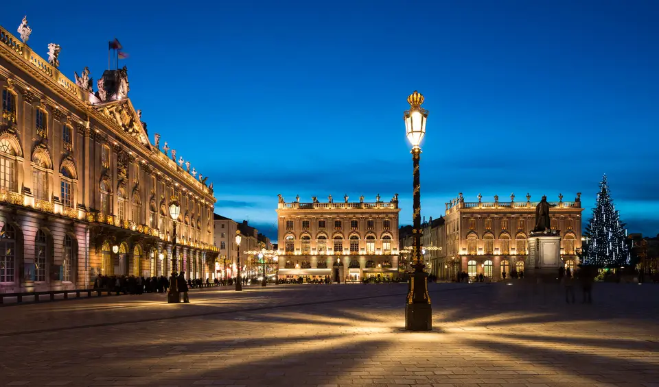
Designed by the court architect Emmanuel Héré de Corny (who lived from 1705 to 1763) and inspired by an original work of his teacher Germain Boffrand, construction of the main square began in March 1752 and concluded in November 1755, with the wider three-square ensemble completed between 1752 and 1756. Sculptor Guibal and Paul-Louis Cyfflé cast a monumental bronze statue of Louis XV for the centre of the Place Royale, which stood until the iconoclasm of the French Revolution removed the royal figure and replaced it with a simple winged allegory, renaming the space first the Place du Peuple and subsequently the Place Napoléon. Later, in 1831, a bronze statue of Stanislas sculpted by Georges Jacquot (depicting the duke standing in flowing robes with a sword in his left hand and his right finger pointing north along his urban axis) was erected on a high marble pedestal at the middle of the square, establishing its permanent name as the Place Stanislas.
Classical Pavilions, Triumphal Perspective, and the Golden Gates of Jean Lamour
The inscribed UNESCO ensemble unfolds along a disciplined north-south axis where classical architectural harmony balances theatrical Baroque and Rococo ornament. Anchoring the southern end, the Place Stanislas measures 125 metres (410 feet) in length and 106 metres (348 feet) in width, paved in light ochre stones crossed by two diagonal lines of darker stone that form a cross motif. Occupying the entire 98-metre southern side of the square stands the Hôtel de Ville, also known as the Palais de Stanislas, built between 1752 and 1755 with the Meurthe-et-Moselle prefectural office positioned at its southeast corner. Flanking the eastern side stand the Opera house (which formerly served as the Bishop's Palace) alongside the Grand Hôtel (known originally as the Hôtel de la Reine and occupied by the Intendant Alliot), while the western side is framed by the Fine Arts Museum (housed in the former Collège de médecine) and the commercial and residential Pavillon Jacquet, all unified by Héré's colossal classical orders.
Along the northern side of the square, Emmanuel Héré kept the flanking pavilions deliberately lower for military defensive reasons, permitting unobstructed artillery crossfire between the Vaudemont and Haussonville bastions. This architectural transition allowed master ironworker Jean Lamour (1698 to 1771), who also forged the grand staircase balustrade and central balcony of the Hôtel de Ville, to enclose the four corners and the east and west openings with magnificent gilded wrought-iron gates and lanterns, earning Nancy its nickname as the City with Golden Gates (or Ville aux Portes d'Or in French). In the northwest and northeast corners, Lamour's gilded ironwork curves around the ornate lead-and-stone Fountains of Neptune and Amphitrite created by the sculptor Guibal (1699 to 1757).
In the middle of the northern fourth side rises the Arc Héré, a monumental triumphal arch designed by Emmanuel Héré that leads directly into the adjoining Place de la Carrière. Extending the main axis northward, the Place de la Carrière develops as a double avenue of trees bordered by symmetrical buildings, including the Tribunal and the restored Héré Pavillion, before terminating at the semicircular hemicycles of colonnades carried across the pre-existing facade of the Palais du Gouvernement. Completing the ensemble just to the east, the Place d'Alliance frames the baroque Fountain of the Place d'Alliance sculpted by Paul-Louis Cyfflé, while the wider civic plan also provided public access to the municipal courts of justice as well as the historic Palais de Fermes.
Walking the Axial Sequence and Inspecting the Ironwork
Because the entire 7-hectare UNESCO core zone is flat, compact, and reserved for pedestrian use, visitors can trace Héré's urban choreography in a single continuous walk across the centre of Nancy, moving from the monumental southern square through the tree-lined avenue to the eastern fountain court.
- Starting at the Place Stanislas: Step onto the light ochre stone pavement of the 125-by-106-metre square to take in the full perspective framed by the 98-metre Hôtel de Ville on the south side and the symmetrical pavilions of the Opera house, Grand Hôtel, Fine Arts Museum, and Pavillon Jacquet. Walk to the northwest and northeast corners to study the gilded ironwork gates and suspended lanterns forged by Jean Lamour alongside the sculptor Guibal's Fountains of Neptune and Amphitrite, then inspect Georges Jacquot's 1831 central bronze statue of Stanislas and the collections inside the Fine Arts Museum.
- Following the Axis to Place de la Carrière: Observe how the lower northern buildings were engineered to permit crossfire between the Vaudemont and Haussonville bastions, then pass beneath the central triumphal arch of the Arc Héré into the Place de la Carrière. Stroll north beneath the double avenue of trees between the restored symmetrical facades and the Tribunal to reach the semicircular hemicycles of colonnades enclosing the Palais du Gouvernement at the far northern end.
- Concluding at the Place d'Alliance: Walk from the southeast corner of the Hôtel de Ville past the Meurthe-et-Moselle prefectural office to the quiet, ordered enclosure of the Place d'Alliance, where Paul-Louis Cyfflé's sculpted central fountain anchors the third square of Stanislas's Enlightenment capital.
From Twentieth-Century Car Park to Restored Pedestrian Masterpiece
Although the Hôtel de Ville was designated a French monument historique on 12 July 1886, the Place Stanislas endured a nearly quarter-century period of low appreciation between 1958 and 1983, when the monumental space served as a surface car parking area between public assemblies and festivities. Its inscription as a UNESCO World Heritage Site in 1983, followed by the 159-hectare buffer zone extension in 2016, spurred a comprehensive ten-month municipal restoration in 2004 and 2005 based strictly on Emmanuel Héré's original 18th-century plans, financed by city alongside local, regional, national, and private funds and inaugurated in May 2005 to celebrate the square's 250th anniversary alongside the full restoration of the ground area, classical facades, gilded iron gates, Tribunal, and Héré Pavillion across the historic squares of Lorraine. Travellers comparing European civic capitals can pair Nancy with Bern or browse our UNESCO World Heritage Atlas for more Enlightenment urban designs.
