


























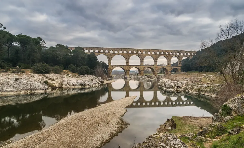
Quick Field Data
- UNESCO Inscription: 1985, inscribed as a technical and artistic masterpiece of early Imperial Roman hydraulic engineering and bridge construction.
- Scale & Footprint: Rises 48.77 to 49 metres across three recessed tiers of arches (measuring 142 metres on the lower tier, 242 metres on the middle tier, and 275 metres, originally 360 metres, on the upper tier), forming the centrepiece of a 50.02-kilometre aqueduct.
- Access & Ticketing: Located within a pedestrianised riverside park near Vers-Pont-du-Gard with a museum and visitor centre on the north bank; check the official site for museum and upper-conduit tour bookings.
- Arrival Logistics: Spans the Gardon River in the Gard department of the Occitanie region between Uzès and Nîmes, accessible via southern French rail and highway routes connecting toward Nice.
Spanning the rocky gorge of the Gardon River close to Vers-Pont-du-Gard within the Occitanie region of southern France, the Pont du Gard remains the highest and among the most intact surviving aqueduct bridges built by Rome in existence. In 1985, the UNESCO World Heritage Atlas in 1985 and protected as a French Monument historique since 1840, this three-storey shelly limestone structure was erected in the middle of the first century AD to carry fresh spring water across the river valley to the Roman colony of Nemausus (modern Nîmes). Rising 48.77 metres above the river at low water and constructed without mortar from an estimated 50,400 tons of precisely dressed stone, the bridge combines monumental hydraulic engineering with airy architectural grace. Travellers exploring southern France from Nice and Provence encounter its golden arches framed by Mediterranean garrigue hills. Three tiers of arches span the river.
The 50-Kilometre Nîmes Aqueduct and Roman Surveying Precision
Although the straight-line distance between the natural Fontaine d'Eure spring system outside Uzès (ancient Ucetia) and the repartition basin (castellum divisorum) in Nîmes is only about 20 kilometres, Roman hydraulic engineers had to plot a winding V-shaped course measuring 50.02 kilometres to circumvent the rugged limestone hills and deep valleys of the Garrigues de Nîmes. Even more challenging was the minimal difference in elevation: the Fontaine d'Eure sits at 76 metres above sea level, just 17 metres higher than the circular distribution basin in Nîmes (which measures 5.5 metres in diameter and 1 metre deep, where water entered through a 1.2-metre opening and exited through ten 40-centimetre pipe holes alongside three floor drains). Across the entire 50-kilometre route, 35 kilometres of which ran underground in stone-lined trenches or solid rock tunnels such as those near Sernhac (up to 66 metres long), supplemented by surface bridges like the Pont Rue near Vers (7.5 metres high), the three-arched Pont de Bornègre (17 metres long), and the Pont de Sartanette (32 metres long), the aqueduct maintained an exceptionally shallow average gradient of 1 in 3,000 (1 centimetre in 182.4 metres), dropping as low as 1 in 20,000 (or 7 millimetres per 100 metres between the Pont du Gard and Saint Bonnet).
By varying the gradient profile, descending more steeply at 0.67 metres per kilometre upstream of the Gardon and dropping only 6 metres over the remaining 25 kilometres downstream, Roman surveyors using the groma, chorobates, and wax tablets lowered the required height of the Pont du Gard by 6 metres to keep it within safe structural limits at 48.77 metres. Over the 456-metre span of the bridge complex itself, the water channel descends just 2.5 centimetres, a gradient of 1 in 18,241. Once operational, the aqueduct delivered roughly 40,000 cubic metres of water every day (taking nearly 27 hours to travel from Uzès to Nîmes) to supply the fountains, public baths, and private homes of the city's 50,000 inhabitants.
Long attributed by scholars such as Émile Espérandieu in 1926 to Augustus's son-in-law Marcus Vipsanius Agrippa around 19 BC, recent archaeological investigations led by Guilhem Fabre indicate that the aqueduct was built between roughly 40 and 60 AD during the reign of Emperor Claudius (41, 54 AD), employing 800 to 1,000 workers over fifteen years at an estimated cost of 30 million sesterces in total, a sum matching half a century of wages for 500 legionary recruits).
Three Recessed Arch Tiers, Pierre de Vers Quarrying, and the Water Specus
Constructed from 21,000 cubic metres of coarse-grained yellowish shelly yellow limestone (called Pierre de Vers in the region) extracted from the Estel quarry just 700 metres downstream on the banks of the Gardon, the Pont du Gard rises across three recessed tiers that taper in width from 9 metres (or 6.4 metres across the main piers) at the bottom to 3 metres at the top. Individual ashlar blocks weighing up to 6 tons were lifted into place using cranes, pulleys, windlasses, and human-powered treadmills, fitted together purely by dry friction and gravity without mortar or clamps. On the stone surfaces, visitors can still see protruding scaffolding bosses alongside Roman quarrymen's assembly marks and Latin positioning inscriptions such as fronte dextra (front right) and fronte sinistra (front left).
To withstand the sudden, violent flash floods of the Gardon, which submerged the entire lower tier in 1958 and struck again in 1998 and 2002, the Roman engineers anchored the piers into solid bedrock with pointed upstream cutwater lips and gave the principal lower arch crossing the river channel a wider span of 24.52 metres (compared with 21.87 metres for the flanking arches). The lower tier measures 142 metres long with 6 arches, the middle tier measures 242 metres long with 11 arches constructed of juxtaposed voussoir rollers, and the upper tier measures 275 metres long (originally 360 metres) with 35 smaller arches (originally 47) supporting the covered water conduit (specus). Measuring 1.8 metres high and 1.2 metres wide, the interior of the conduit was lined with concrete and pottery-shard stucco coated in olive oil and maltha (a waterproof paste of slaked lime, pork grease, and unripe fig juice). A 1989 microtopographic survey revealed that the slight upstream curvature of the upper tiers results from daily thermal expansion and contraction of the stone by 5 millimetres under the sun.
From Medieval Toll Bridge to Pedestrian Park and Literary Landmark
After maintenance by Roman circitores ceased from the fourth century onward, calcium carbonate sinter encrustations up to 50 centimetres thick and plant roots clogged the channel, ending water delivery around the sixth century (or up to the ninth century in some estimates). Throughout the Middle Ages, the bridge survived because the French crown in the thirteenth century granted the lords and later the Bishops of Uzès the right to collect river-crossing tolls in exchange for upkeep. In the 1620s, Henri, Duke of Rohan dangerously notched away one-third of the thickness of the second-tier piers so his Huguenot artillery and carts could squeeze along the lower deck. Repaired in 1703, the Roman piers were relieved of carriage traffic in 1743 when engineer Henri Pitot built an adjacent road bridge alongside the lower tier.
Celebrated by royal visitors including Charles IX in 1564, Louis XIV in 1660, and Louis XVI (who commissioned Hubert Robert's painting in 1786), as well as writers Jean-Jacques Rousseau in 1738, Alexandre Dumas, Prosper Mérimée in 1835, Joseph Méry in 1853, Henry James in 1884, and Hilaire Belloc in 1928, the monument was rescued from structural decay by Emperor Napoleon III, who visited in 1850 and funded architect Charles Laisné's comprehensive restoration between 1855 and 1858. Between 1996 and 2000, architect Jean-Paul Viguier and the Gard department removed all motor traffic and commercial clutter, opening an underground north-bank museum and pedestrian conservation park managed since 2003 by a public cultural body.
- Walk across Henri Pitot's 1743 bridge deck for close-up stone markings: Cross the pedestrianised eighteenth-century bridge alongside the first tier to inspect the pointed upstream flood cutwaters, protruding scaffolding blocks, and Roman assembly numerals carved into the Pierre de Vers blocks.
- Book a guided walk through the upper third-tier water conduit: Reserve a guided tour slot at the north-bank visitor centre to climb the internal stairs installed during the 1850s restoration and walk directly inside the 1.8-metre-high Roman specus where calcium carbonate sinter crusts still cling to the maltha-lined walls.
- Follow the downstream riverbank path to the Estel Roman quarry: Walk 700 metres downstream along the Gardon riverbank to see the ancient limestone quarry faces from which 50,400 tons of shelly stone were extracted and floated or hauled to the bridge site.
