


























Quick Field Data
- UNESCO Inscription: 1997, extended in 1999 (Mixed natural and cultural World Heritage site spanning Huesca in Aragon, Spain, and the northern slope in France)
- Scale & Footprint: 30,639 hectares centred on the 3,352-metre limestone massif of Monte Perdido (Mont Perdu), bridging Ordesa y Monte Perdido National Park and Pyrénées National Park
- Access & Ticketing: Jointly protected by Spanish and French national park authorities; check the official site for seasonal shuttle bus requirements into Ordesa Valley and high-mountain refuge bookings
- Arrival Logistics: Torla and the southern mountain valleys provide the primary southern road approaches in Aragon, while Gavarnie and the northern mountain valleys serve the northern French valleys
Tectonic Nappes, Glacial Cirques, and Deep Fluvial Canyons
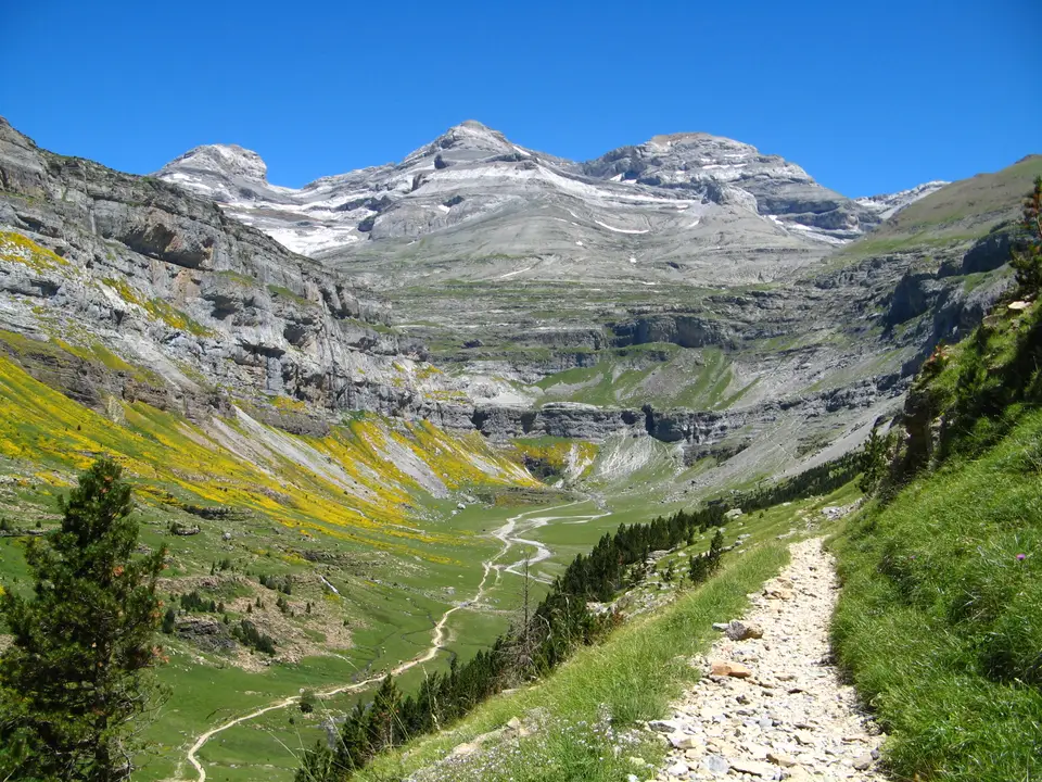
Rising across the central crest of the Pyrenees along the international border between Spain and France, the Pyrénées - Mont Perdu World Heritage site encompasses 30,639 hectares of high-altitude karst peaks, sheer rock amphitheatres, and deeply incised canyons. For Spain, the UNESCO World Heritage Atlas in 1997 and extended in 1999 as a mixed natural and cultural property, the landscape radiates outward from the calcareous massif of Monte Perdido, known in French as Mont Perdu, which reaches 3,352 metres above sea level as the highest limestone summit in Europe. Formed by the collision of the Spanish and European continental plates, massive horizontal beds of Upper Cretaceous and Eocene marine limestone, sandstone, and marl were thrust southward in overlapping tectonic nappes, uplifting fossil-rich seabed sediments more than three kilometres into the sky.
Subsequent Pleistocene glaciation and post-glacial karstic erosion carved strikingly asymmetrical landforms on the northern and southern flanks of the divide. On the cooler, wetter northern French slope in the northern French Pyrenees, valley glaciers gouged three monumental semi-circular rock amphitheatres: the Cirque de Gavarnie, the Cirque d'Estaubé, and the Cirque de Gavarnie and neighbouring cirques. At Gavarnie, stepped limestone ledges rise 1,500 metres in concentric tiers to three-thousand-metre peaks such as Marboré and Cilindro de Marboré, while snowmelt plunges hundreds of metres down the headwall in the great waterfall of Gavarnie, the highest waterfall in mainland France. High on the ridge above the cirque above the cirque, a natural 40-metre-wide cleft in the frontier rock wall linking the French approach to the Spanish slopes.
On the sunnier, drier southern slopes inside Huesca province in Aragon, torrential rivers and ancient glaciers cut four immense radial canyons into the uplifted limestone plateau: the Ordesa Valley drained by mountain torrents, the Añisclo Canyon carved by deeply incised streams, the narrow Escuain Gorge, and the glaciated Pinet Valley. Beneath the surface, rainwater and snowmelt percolate through vertical shafts, sinkholes, and subterranean galleries across more than 10,000 to 30,639 hectares of alpine karst, feeding powerful resurgence springs far down the canyon walls. Snow lingers on the high ledges. Rising to 3,352 metres on Monte Perdido, or 3,355 metres in some surveys alongside the 3,348-metre peak of Cilindro de Marboré, the massif preserves a remnant hanging glacier on its north face that shrank significantly after the Little Ice Age yet remains a key site for studying alpine glaciation between the Alps and the Caucasus Mountains. Across the 30,639-hectare core zone, first inscribed in 1997 and extended in 1999 to unite Spain's Ordesa y Monte Perdido National Park, initially created across 1918 and expanded in 1982, with the adjacent French national park lands around Gavarnie, Héas, and Aragnouet, the two deep southern canyons of Ordesa and Añisclo pair with the Escuain gorges and the northern glacial cirques of Gavarnie and Estaubé.
Altitudinal Floristic Zones and Transhumant Pastoral Landscapes
Because the massif stands at the climatic boundary between cool, humid Atlantic air masses entering from the Atlantic to the north and warm, dry Mediterranean and continental influences rising from the southern plains to the south, its slopes support an extraordinary variety of habitats across five distinct vegetation belts. Over 1,500 vascular plant species grow within the site, including numerous species endemic to the Pyrenees. In the sheltered canyon bottoms of Ordesa and Añisclo, evergreen holm oaks and Mediterranean shrubs mingle with dense montane forests of beech, silver fir, mountain pine, and birch. Above the timberline, twisted stands of mountain pine, give way to subalpine meadows and high calcareous scree fields where endemic Pyrenean cushion plants and cliff flora, clings to vertical limestone cliffs.
This vertical mosaic shelters 32 mammal species and numerous breeding bird species. Large herds of Pyrenean chamois or isard, bound across the alpine ledges, while the semi-aquatic Pyrenean desman and the endemic Pyrenean brook salamander inhabit cold mountain torrents. Overhead, the massif functions as a stronghold for Europe's cliff-nesting raptors, most especially the bearded vulture or lammergeier, which drops marrow bones onto high rock slabs, alongside the golden eagle, Egyptian vulture, griffon vulture, wallcreeper, rock ptarmigan, and Western capercaillie.
Equally central to the site's inscription is its living cultural tradition of high-mountain pastoralism, shaped over centuries by agro-pastoral communities across the valleys of Torla, Tella, Parzan, Boucharo, Aragnouet, Héas, Gavarnie, Héas, and Pinet. From the Middle Ages onward, French and Spanish valley communes negotiated formal cross-border grazing treaties known as faceries or lies et passeries, granting shepherds from the drier Aragonese valleys summer pasture rights on the lush northern slopes around Gavarnie and Héas in exchange for mutual peace even when their kingdoms were at war. Each summer, flocks of sheep, cattle, and horses ascend along stone-walled droveways to high mountain pastures, or estives, punctuated by dry-stone shepherd huts called cabanes or mallatas, hay barns, terraced fields, and romanesque village churches. Archaeological excavations inside high caves around Tella, Añisclo, and Escuain demonstrate that human presence across these limestone valleys dates back to the Upper Paleolithic, when prehistoric hunters and early pastoralists first utilized the karst shelters. Over the centuries since the Middle Ages, written documents preserved in local valley archives have recorded the legal customs governing communal woodlands, summer pastures, irrigation channels, and cross-border livestock passage between the Spanish slopes of Huesca Province in Aragon and the French valleys to the north. Because industrialisation and modern intensive agriculture bypassed these steep mountain valleys during the modern industrial era, the traditional settlement pattern of compact stone villages, terraced hay meadows, high summer barns, and seasonal transhumance trails survived intact as a living record of European mountain society.
Walking the Ordesa Canyons and Gavarnie Amphitheatres
Travellers exploring the region from Barcelona can drive northwest across Aragon toward the southern trailheads of Ordesa y Monte Perdido National Park, founded in 1918 as one of Spain's earliest national parks, or cross the Pyrenees to reach the French valleys of Pyrénées National Park, established in 1970 and 1982. Because the central ridge exceeds 3,352 metres with no road crossing directly over the massif, road transfers between Torla and Gavarnie require driving around the range via the mountain road passes, while hikers cross on foot via the high pass of the high frontier ridge.
- Ordesa Valley floor and the Soaso cirque trail: From the medieval stone village of Torla, board the seasonal park shuttle to the Ordesa Valley trailhead. The classic valley floor footpath follows mountain torrents through beech and fir woods past the stepped waterfalls into the broad glacial Cirque de Soaso at the foot of Monte Perdido, while experienced scramblers with steady footing can return along the high cliffside balcony path.
- Cirque de Gavarnie and the high frontier ridge ascent: Starting from the French village of Gavarnie, a gentle valley walk alongside the mountain stream leads directly into the limestone bowl of the Cirque de Gavarnie toward the spray of its high waterfall. For high-alpine hikers, the route from Boucharo climbs across the frontier ridge, leading onward to the Spanish Refuge of Góriz on the southern flank of Monte Perdido.
- Añisclo Canyon and the Pinet and Estaubé valleys: Drive the narrow one-way scenic road through the depths of the Añisclo Canyon to walk the riverside bridge trail past the prehistoric hermitage cave of the canyon entrance carved into the limestone cliff. Farther east, the wide glacial floor of the Pinet Valley beneath the north face of Monte Perdido and the vast panoramic amphitheatre of the Cirque de Gavarnie and neighbouring cirques on the French side offer quieter alpine walks across transhumant summer pastures.
