Quick Field Data
- UNESCO Inscription: 2013 (Ref. 247, 37th World Heritage Committee session), serial cultural site of six citadels across Rajasthan; Criteria (ii) and (iii).
- Scale & Footprint: 736 hectares designated collectively across Chittorgarh, Kumbhalgarh, Ranthambore, Gagron, Amber, and Jaisalmer, featuring ramparts reaching 20 to 36 kilometres and functioning water harvesting networks.
- Access & Ticketing: Chittorgarh, Kumbhalgarh, Ranthambore, and Jaisalmer fall under India's 1951 AMASR Act managed by the Archaeological Survey of India. Amber and Gagron fall under the 1968 Rajasthan Monuments Act; verify fort passes, park permits, and jeep transfers via official portals.
- Arrival Logistics: Primary commercial flights reach Jaipur International Airport (JAI), 169 kilometres from the regional midpoint and beside Jaipur (174 kilometres), while Ahmedabad (AMD) lies 359 kilometres away and Delhi (DEL) 396 kilometres. Kishangarh Airport Ajmer (KQH), 94 kilometres away, operates limited domestic routes.
Six Citadels Included in Rajasthan's UNESCO Series
Across northwestern India, more than one hundred fortifications occupy rocky hills, forested plateaus, and desert outcrops. Preparing the Hill Forts of Rajasthan UNESCO dossier meant screening over one hundred recorded strongholds down to 54 military sites, then 24, and shortlisting 13 before selecting five Aravalli Range citadels plus desert Jaisalmer in June 2013. Unlike ground fortresses such as Junagarh or court-only citadels lacking civilian neighbourhoods like Jodhpur's Mehrangarh, the six Rajput fortresses met four strict selection tests. Each combined hilltop terrain adaptation, royal power centres, sacred grounds, and enclosed civilian settlements erected between the 5th and 18th centuries CE.
Spread across six districts of Rajasthan, these citadels exemplify four classical Indian fort typologies defined by literary texts: hilltop forts, forest forts, water forts, and desert forts. Chittorgarh commands a 180-metre bluff in Mewar, Kumbhalgarh crowns a 1,100-metre Aravalli crest in Rajsamand, and Amber climbs a forested ridge above Maota Lake just 11 kilometres from Jaipur. Beyond the central range, Ranthambore stands deep inside woodland within Ranthambore National Park near Sawai Madhopur, Gagron anchors the river confluence of the Ahu and Kali Sindh in Jhalawar, and Jaisalmer protects an inhabited sandstone town inside the western Thar Desert.
Rather than isolating court soldiers on barren stone, Rajput rulers enclosed active commercial bazaars, royal palaces, learning centres, and Hindu and Jain temples inside sweeping curtain walls reaching up to 20 kilometres around major compounds. Engineers cut stepped reservoirs, stepwells, and check-dams across natural slopes to store seasonal monsoon rain for long sieges, leaving practical water systems still working today. While drawing eclectically on Indian traditions as well as Sultanate and Mughal design, these citadels later influenced Maratha fortress planning across western India.
Heritage oversight operates via Rajasthan's State Level Apex Advisory Committee (created in May 2011) and the Amber Development and Management Authority. Chittorgarh, Kumbhalgarh, Ranthambore, and Jaisalmer hold national protection under the 1951 AMASR Act and its 200-metre buffer rule under the 2010 amendment, while Amber and Gagron hold 1968 state protection including Amber's 50-metre buffer. Even with formal 2011-to-2015 management plans, conservation teams address industrial quarrying, cement factories, and zinc smelters near Chittorgarh, exterior plaster replacements at Amber and Gagron, structural decay at Chittor and Kumbhalgarh, and water seepage threatening Jaisalmer's sandstone hill.
Chittorgarh Fort Rajasthan History and Mewar Strongholds
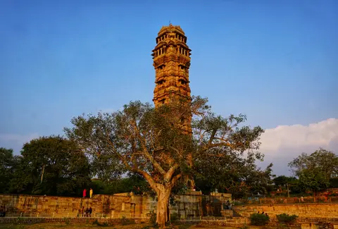
Sprawling across 280 hectares atop a steep 180-metre hill overlooking the Berach River, Chittorgarh Fort Rajasthan ranks among India's grandest fortresses and the former capital of Mewar. Known originally as Chitrakut and linked in tradition to Mori ruler Chitrangada Mori (with Bhimlat Kund linked in legend to Bhima striking the rock for water), the summit holds 65 historic structures. These include four palaces, 19 large temples, four memorials, victory towers like Rana Kumbha's Vijay Stambh, ninth-century Buddhist stupas by Jaimal Patta lake, and 22 surviving water bodies out of 84 capable of storing 4 billion litres for 50,000 troops over four years. Situated 233 kilometres from Ajmer along national highways linking Delhi and Mumbai, the fort rises above the post-1568 Lower Town.
Few places capture Rajput history as vividly as Chittorgarh Fort Rajasthan history across three epic sieges. After Guhila ruler Bappa Rawal reportedly captured Chitrakut around 728 or 734 CE, Delhi Sultan Alauddin Khalji seized Chittor in 1303 after an eight-month siege against Ratnasimha, slaughtering 30,000 people and renaming it Khizrabad until Sisodia founder Hammir Singh regained Mewar control before 1378. Under Maharana Kumbha (1433 to 1468), builder of 32 of Mewar's 84 fortresses, Chittor flourished artistically and militarily. Later, grandson Rana Sanga expanded Mewar from the Satluj in Punjab to the Narmada River and Bayana, defeating Ibrahim Lodhi at Khatoli and Dholpur and advancing as far as Ahmedabad. Babur's modern cannons, matchlocks, swivel guns, and mortars eventually shattered his 100,000-strong Rajput confederacy at Khanwa in 1528 before Medini Rai fell at Chanderi. Later, Bahadur Shah of Gujarat sacked the citadel in 1535 when Rani Karnavati led 13,000 women in jauhar as 3,200 warriors rode out. Finally, Mughal Emperor Akbar captured Chittorgarh in 1567 to 1568, prompting Rana Udai Singh II to shift Mewar's capital permanently to Udaipur.
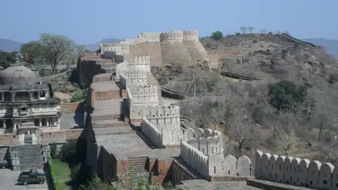
Located 84 kilometres northwest of Udaipur and 48 kilometres from Rajsamand, Kumbhalgarh Fort complements Chittor as Mewar's great Aravalli bastion, nicknamed the Great Wall of India. Ordered by Rana Kumbha in 1448 over an older Maurya-linked fort and designed by named architect and treatise writer Mandan (author of Rajvallabh), Kumbhalgarh stretches 36 kilometres of continuous perimeter walls with 4.5-metre-thick frontal masonry. Seven fortified gateways (Aaret Pol, Halla Pol near the 1578 Badshahi Bavdi stepped tank, double-storey Hanuman Pol, main Ram Pol, eastern Vijay Pol, plus Bhairon, Nimboo, Chaugan, Pagda, and Ganesh gates) lead up to Badal Mahal palace. Over 360 Hindu and Jain temples stand inside, led by the 1458 Neel Kanth Mahadeva shrine resting on 24 pillars with a 12-handed black-stone Shiva idol. Nearby stand Ganesha, Charbhuja, Mataji, Surya Mandir, and Mamadeo temples beside Kunwar Prithviraj's cenotaph, together with Svetambara Jain shrines including Vedi (1457), 52 Bawan Jain shrines, Parsva Natha (1513), Juna Bhilwara, Pital Shah, and Golera groups. Kumbhalgarh repulsed Gujarat and Malwa armies in 1457, 1458, and 1467 before falling once in April 1578 after a six-month Mughal siege under Shahbaz Khan, until Kumbhalgarh-born Maharana Pratap retook it in 1583 and British officer James Tod negotiated handover from garrison sanyasis in 1818.
Rajput Builders and Court Architecture From Amber to Jaisalmer
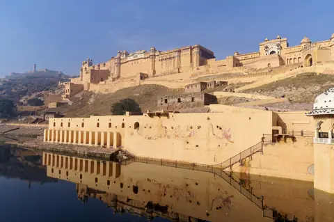
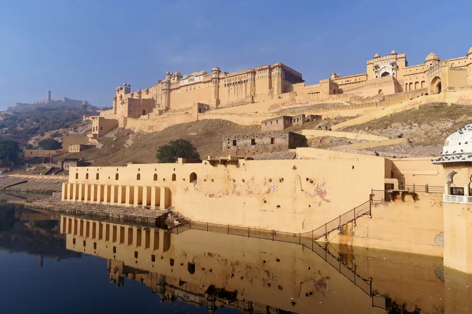
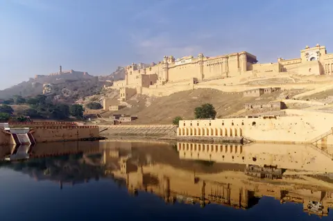
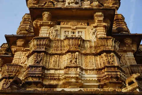
Tracing these six fortresses highlights centuries of regional synthesis between Rajput court planning and Mughal decoration. Standing 11 kilometres north of Jaipur on Cheel ka Teela ridge beside Maota Lake, Amber Fort served Kachwaha rulers of Dhundhar from 1037 until Sawai Jai Singh II moved his capital down to Jaipur in 1727. Initiated by Raja Man Singh and expanded over 150 years by Mirza Raja Jai Singh (1621 to 1627) and Sawai Jai Singh (1693 to 1743), Amber links via an underground escape tunnel directly to Jaigarh Fort. Entered past Suraj Pol (Sun Gate) and Jaleb Chowk parade court up to frescoed Ganesh Pol, the palace climbs across four courtyards topped by Suhag Mandir's marble jali screens.
Inside the upper courts sit the 27-colonnade Diwan-i-Aam, Man Singh's 12 queens' suites with private king staircases, and the silver-doored Shila Devi temple commemorating Man Singh's 1604 victory over the Raja of Jessore in Bengal. Carved from a black stone slab linked in legend to Mahabharata stories and flanked by a coral Ganesha carving, Shila Devi hosted Navaratri animal sacrifices until a 1975 legal ban and 1980s ending of royal rituals. Opposite mirror-lined Sheesh Mahal inside Jai Mandir and upper Jas Mandir rises Sukh Niwas, entered through sandalwood doors into marble walls inlaid with chini khana niches cooled by water channels flowing into the central Mughal garden. Once drawing 5,000 visitors daily (1.4 million in 2007), Amber today encourages jeep rides up the narrow 4WD lane instead of elephant rides.
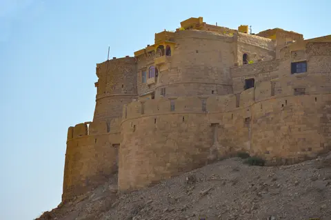
Three contrasting forts complete Rajasthan's six-site listing. In the western Thar Desert, Jaisalmer Fort, raised in 1156 CE by Bhati Rajput ruler Rawal Jaisal after leaving Lodhruva, endures as a living medieval fortress housing nearly one-fourth of the old city's population and finely carved Jain temples. Amid forest near Sawai Madhopur, Chahamana-built Ranthambore Fort preserves 8th-to-10th-century origins, brief 13th-century Delhi Sultanate rule, and Hammir Palace ruins ranking among India's oldest surviving palace structures overlooking Ranthambore National Park. Finally, in Jhalawar district, 12th-century Gagron Fort built by Dod king Bijaldev Singh and held later by Sher Shah and Akbar functions as a river-and-hill jaladurg. Surrounded on three sides by the Ahu and Kali Sindh river confluence plus a carved fourth-side moat, it remembers 14 battles and two royal jauhars.
Modern conservation teams balance intense visitor popularity with fragile historic stone across all six districts. At Jaisalmer, improved urban drainage infrastructure remains crucial to stop water seepage beneath the sandstone hill and safeguard views across the expanding desert town. Meanwhile, shared interpretation plans link Amber's annual 1.4 million visitors to quieter fortresses like Gagron, showing how six distinct Rajput kingdoms expressed one coherent regional military architecture.
Access Zones Across the Six Rajput Fortresses
Because the six inscribed fortresses span desert sand, Aravalli peaks, and southern river valleys hundreds of kilometres apart, dividing trips around Jaipur, Udaipur, and Jaisalmer makes overland distances practical.
| Complex Zone | Key Highlights | Access & Ticket Rule |
|---|---|---|
| Amber Fort (Jaipur District). | Four palace courtyards, Suraj Pol, Ganesh Pol frescoes, 27-column Diwan-i-Aam, Sheesh Mahal, Sukh Niwas, and Maota Lake. | Situated 11 kilometres from Jaipur by road or 4WD jeep ascent. State Monument tickets apply at fort gates. |
| Chittorgarh & Kumbhalgarh (Mewar). | 280-hectare Chittor plateau with Vijay Stambh and cisterns, plus Kumbhalgarh's 36-kilometre perimeter walls. | Protected nationally with ASI entry passes. Chittor's 1-kilometre road ascends Ram Pol; Kumbhalgarh sits 84 kilometres north of Udaipur. |
| Jaisalmer Living Fort (Thar Desert). | 1156 golden-sandstone battlements, inhabited old-city quarters, royal palace museum, and carved Jain temples. | Outer residential lanes open freely on foot. Palace rooms and individual heritage museums charge gate fees. |
| Ranthambore & Gagron Zones. | Hammir Palace ruins and temples inside Ranthambore forest; Gagron water fort at Ahu and Kali Sindh confluence. | Ranthambore access ties to national park reserve permits. Gagron welcomes visitors under Rajasthan state monument rules. |
Three Architectural Details Across Rajasthan's Six Hill Forts
- Gravity-Fed Monsoon Reservoirs at Chittorgarh: Walk beside Bhimlat Kund and the stone stepwells on Chittor's 280-hectare summit to see how 22 surviving water bodies captured seasonal rainfall to sustain huge armies behind 180-metre cliffs.
- Mandan's Seven-Gate Ascent at Kumbhalgarh: Climb past Aaret Pol, Halla Pol, Hanuman Pol, and Ram Pol toward Badal Mahal to observe how sharp switchbacks, octagonal towers, and Badshahi Bavdi stepped tanks shielded 4.5-metre walls against artillery and escalade.
- Mirror Vaults and Cooling Channels at Amber: Cross the courtyard garden between the convex glass mosaics of Sheesh Mahal and Sukh Niwas, where piped water flowed smoothly down an open marble floor channel to cool summer court chambers.
Location Strategy and Connecting Rajasthan's Forts From Jaipur
Navigating the wide desert-to-river spread across Rajasthan starts neatly at Jaipur International Airport (JAI), 169 kilometres from the central regional midpoint and right beside Amber Fort. Travellers heading directly into southern Mewar also route through Ahmedabad (AMD) at 359 kilometres, Delhi (DEL) at 396 kilometres, or limited domestic services into Kishangarh Airport Ajmer (KQH) at 94 kilometres. Dry, crisp months from autumn through early spring offer comfortable climbing up fort ramps, clear views down Kumbhalgarh's 36-kilometre wall, and seasonal celebrations such as Kumbhalgarh's three-day heritage festival.
Rather than racing across all six forts in a single sweep, anchor two nights near Jaipur to inspect Amber Fort's four courtyards before moving south through Chittorgarh and Kumbhalgarh or west to Jaisalmer. Begin planning your route via our Jaipur destination guide, and explore additional Indian heritage monuments inside our UNESCO World Heritage Atlas.