Quick Field Data
- UNESCO Inscription: 2009 (Ref. 1269), cultural Late Archaic urban site in Barranca Province, Lima Region, Peru; Criteria (ii), (iii) and (iv).
- Scale & Footprint: 626.36-hectare protected archaeological site perched 350 metres above sea level above the Supe River, holding roughly 60 to 150 hectares of dense excavated pyramids, plazas and residences.
- Access & Ticketing: Managed by Peru's Caral-Supe Special Archaeological Project (PEACS) under an updated Management Plan; verify official gate schedules and licensed site guides on arrival.
- Arrival Logistics: Closest major commercial air hub is Jorge Chávez International Airport (LIM) near Lima, 133 kilometres southeast (roughly 182 kilometres overland north of Lima and 23 kilometres from the coast). Broader Peruvian itineraries reach Machu Picchu (597 kilometres southeast).
Late Archaic Foundations in the Supe Valley and Norte Chico
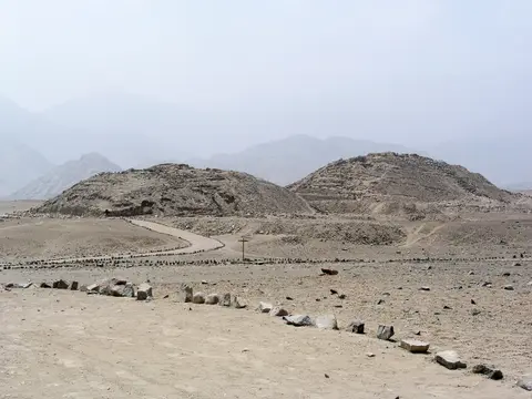
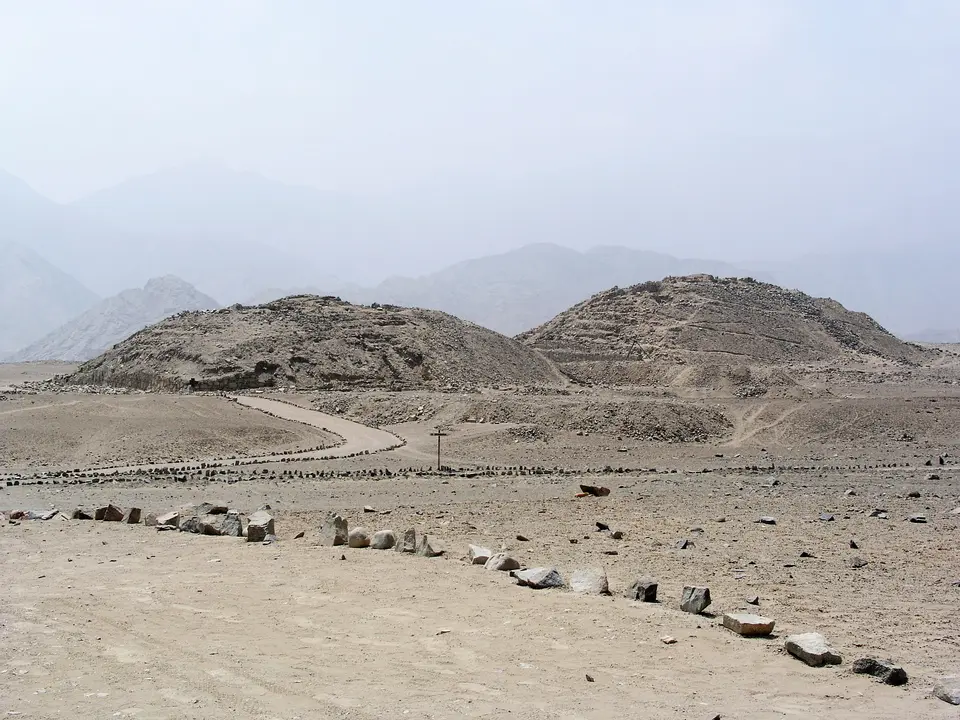
Positioned 182 kilometres north of Lima and 23 kilometres inland, Caral-Supe crowns a dry desert terrace above the Supe River. Radiocarbon studies place this oldest known urban civilisation in the Americas between 3000 and 1800 BC, spanning the Late Archaic and Lower Formative periods roughly 1,500 years before Mesoamerica's Olmecs. Flourishing contemporaneously with Egypt's great pyramids, Caral operated as the ceremonial and administrative heart of the caral supe norte chico peru tradition. Intensive urban occupation peaking between roughly 2600 and 2000 BC housed around 3,000 residents inside Caral itself.
Rather than standing in isolation, the city anchored a densely settled caral supe valley peru network of 18 to 19 temple settlements spread across 90 square kilometres, supporting an estimated regional population near 20,000 people sharing identical platform and stone-circle architecture. Nearby coastal fishing town Áspero near the Supe River mouth supplied marine protein in exchange for inland cotton and agricultural crops; 2016 excavations at Áspero exposed a high-status woman buried around 2500 BC with earlier child sacrifice contexts. Neighbouring Late Archaic sites such as Bandurria and newly opened Peñico (opened to visitors in 2025) reinforce how early coastal and river valley communities co-evolved across northern Peru.
Modern discovery unfolded gradually across more than a century of Andean archaeology. German-born scholar Max Uhle surveyed Caral in 1905 while cataloguing ancient coastal cemeteries, yet failed to recognise its eroded gravel hills as stepped pyramids. Paul Kosok examined the ruins more closely in 1948, though fellow researchers dismissed his early dating because pre-ceramic monumentality seemed improbably vast. After Peruvian architect Carlos Williams documented Caral in his 1975 Supe Valley architectural survey, archaeologist Ruth Shady launched major excavations confirming its 4,600-to-5,000-year antiquity. Subsequent studies by Jonathan Haas, Winifred Creamer and PEACS researchers reinforced how Supe Valley sites illuminate the pristine origins of Andean state architecture over four millennia.
High-precision radiocarbon dating of woven reed carrying bags (shicras) packed with quarry stones directly inside pyramid cores established a benchmark date of 2627 BC, though deeper unexcavated layers may prove older still. Research led by Shady reveals a society thriving on long-distance trade and shared ritual rather than warfare: excavations have yielded zero battlements, weapons or mass combat trauma, contrasting sharply with weapon carvings at later coastal sites like Sechín Bajo. Finds such as monkey motifs even suggest early exchange networks reaching Amazonian lowlands across the Andes.
Upper and Lower Halves, Six Pyramids, Quipus, and Bone Flutes
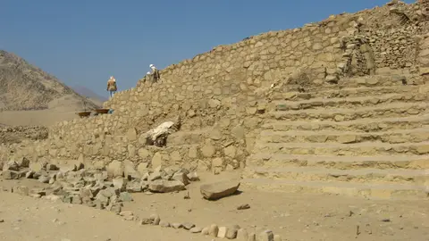
Carefully divided by the natural terrain of the Supe River valley, the city of caral supe peru unfolds across two planned urban halves reflecting clear social hierarchy. On higher desert ground sits the Upper Half, dominated by six grand pyramidal complexes paired with open public plazas and elite residences. These six monumental structures comprise the Great Temple (Templo Mayor), Central Pyramid, Quarry Pyramid, Lesser Pyramid, Pyramid of the Gallery and Pyramid of the Huanca. Flanking domestic quarters yielded luxury diet remnants such as sea lion bones, confirming privileged status linked closely to temple leadership.
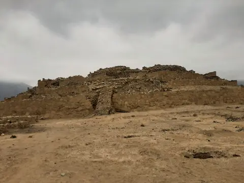
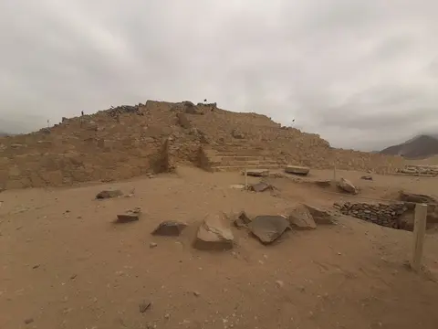
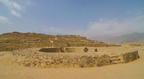
Monumental engineering peaks at Templo Mayor, rising 28 metres high across a stepped stone-and-earth base measuring 150 metres long and 110 metres wide. Fronting key pyramids sit sunken circular ceremonial plazas framed by staircases, low benches and fire hearths engineered to frame ritual music and elite processions before gathered crowds. Across the valley floor stretches the Lower Half, where smaller multi-purpose dwellings housed labourers eating primarily cultivated crops and fish rather than elite marine meats, anchored beside one monumental precinct named the Temple of the Amphitheatre. Scholars interpret this clean spatial division across the river valley as intentional planning expressing entrenched political and ritual stratification.
Artefacts recovered across temples illuminate extraordinary cultural sophistication well before Andean pottery or metallurgy emerged. Excavators uncovered an intact knotted textile cord identified as the Americas' oldest quipu, pushing back the Andean knot-recording system mastered later by the Inca Empire by millennia. Harvard scholar Gary Urton notes that binary cord patterns could encode phonological or logographic information much like early writing systems. Nearby temple chambers also yielded 32 flutes carved from condor and pelican bones plus 37 cornetts fashioned from deer and llama bones, with flutes radiocarbon dated around 2170 BC (plus or minus 90 years).
Ceremonial finds confirm complex ritual life woven directly into construction and worship. One excavated infant burial lay carefully wrapped with a stone bead necklace, while a separate skeleton dating near 3000 BC showed skull fractures and finger mutilation suggesting human sacrifice embedded in foundation or ceremonial rites. Just west of the main site on open desert gravel, excavators Marco Machacuay and Rocío Aramburú discovered a striking ground-etched geoglyph in 2000 beside stone circles. Depicting a human face with streaming hair and a gaping mouth linked to nearby Chupacigarro, the figure parallels etched wall motifs 240 kilometres north at Cerro Sechín in the Casma Valley.
Unlooted Preservation, Radiocarbon Dates, and Land Pressures
Caral owes its extraordinary physical integrity both to its early abandonment around 1800 BC and the complete absence of gold or silver metallurgy during the Late Archaic era. Once urban life faded, later Andean groups disturbed the central city very little. Archaeological layers reveal only two sparse peripheral occupations (once during the Middle Formative period around 1000 BC and once during the States and Lordships era between AD 900 and 1440), both confined safely to city outskirts without tearing down early stone pyramids. Lacking metallic treasures, Caral also escaped the systematic tomb looting that scarred later pre-Columbian coastal centres.
Surrounding valley land strengthens the visual authenticity of the entire 626.36-hectare archaeological reserve. Because urban sprawl concentrated farther south around metropolitan Lima, the middle Supe Valley retains traditional non-industrialised agriculture framing the barren desert terrace. Inside protected lines, tourism facilities remain strictly low-impact structures built from local materials so modern concrete never overwhelms ancient stepped pyramids. Radiocarbon analysis managed continuously by the Caral-Supe Special Archaeological Project (PEACS) verifies authentic Late Archaic chronology from 3000 to 1800 BC. Excavations led by Ruth Shady also show why scholars regard Caral as the blueprint for urban planning that guided Andean societies rising and falling across four subsequent millennia. Neighbouring sites across the valley, including Bandurria, reinforce ongoing scholarly research into how coastal fishing surpluses and inland irrigation first produced permanent monumental cities in South America.
Yet sustaining peace around this 5,000-year-old site requires active protection against modern rural encroachment. Under an updated Management Plan implemented since late 2008, PEACS enforces strict conservation buffers safeguarding fragile mud-plaster floors, shicra masonry and desert geoglyphs. Early in 2021, land disputes flared between local squatters erecting informal housing and archaeologists defending perimeter heritage lines, exposing persistent urban expansion pressures north of Lima. Ongoing legal enforcement and local community education remain essential to shield buried Archaic foundations from unauthorised digging or construction.
Visitor circuits across the caral supe ancient city peru keep fragile pyramid stairways protected while sharing cutting-edge Norte Chico discoveries. Guided paths cross compacted desert sand connecting Upper Half plazas directly toward the sunken circular court of Templo Mayor and Lower Half Amphitheatre structures. Excavations across coastal Áspero and middle-valley terraces show how inland growers traded cotton and crops for Pacific marine catches without relying on fortifications or ceramic vessels. By pairing quiet site preservation with nearby sister locations like Áspero and Peñico, Peruvian heritage authorities illustrate how peaceful trade, cotton textiles, condor-bone music and monumental earthen planning birthed Andean statehood five millennia ago.
Access Zones Across the Sacred City of Caral-Supe Peru
Following any caral supe peru map reveals a crisp split between elevated monumental pyramids and lower valley residential quarters along the Supe River terrace. Always travel with authorised PEACS site guides along roped desert walkways to protect fragile stone-and-mud walls.
| Complex Zone | Key Highlights | Access & Ticket Rule |
|---|---|---|
| Upper Half and Templo Mayor | 28-metre Great Temple, sunken circular plaza, Central, Quarry, Lesser, Gallery and Huanca pyramids plus elite residences. | Official PEACS entry tickets and mandatory site guides keep visitors strictly along designated perimeter pathways. |
| Lower Half and Amphitheatre | Temple of the Amphitheatre sunken court and multi-room residential blocks built for valley farmers and labourers. | Guided foot trails cross southern lower slopes; climbing fragile adobe-plastered platform walls is strictly prohibited. |
| Western Desert Geoglyph Sector | 2000-discovered ground-etched face geoglyph, circular stone lines and nearby Chupacigarro ceremonial precinct. | Delicate desert surface features on the western plain; check visitor centre rules before walking outer desert trails. |
| Supe Valley Sister Sites | Coastal fishing complex Áspero (23 kilometres downstream) and newly opened Peñico settlement along the valley road. | Separate regional valley stops managed by PEACS; combine smoothly with Caral during full-day coastal excursions. |
Three Architectural and Material Details on the Supe Terrace
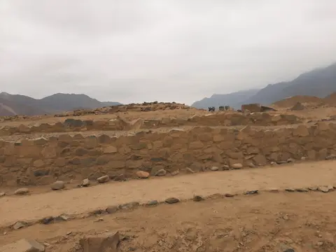
- Shicra Woven Reed Quarry-Stone Bags: Inspect exposed platform retaining walls where Caral builders stacked net bags woven from native reeds stuffed with rough quarry stones inside pyramid cores to distribute seismic shock evenly.
- Sunken Circular Plazas Facing Pyramid Stairways: Stand overlooking the recessed stone circle anchored in front of Templo Mayor and the Amphitheatre to observe ceremonial stages built millennia before later Inca plazas.
- Non-Industrial Valley Oasis Framing Arid Pyramids: Look across the sharp boundary separating Caral's dry gravel plateau from green irrigated Supe River fields below, showing how farming water supported urban pyramid construction uphill.
How to Reach Caral Supe Peru From Lima and Machu Picchu
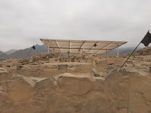
Understanding caral supe peru geographical location helps schedule an effortless day journey north along Peru's arid Pacific highway corridor. Sitting 182 kilometres north of central Lima and 23 kilometres inland off the coastal Pan-American highway, Caral enjoys dry desert skies nearly year-round with mild coastal breezes even when highland Andes routes face wet rains. Morning departures from Lima beat stiff afternoon valley winds across exposed sandy plazas while giving clear side-light across stepped earthen terraces.
Travellers exploring caral supe culture peru should allocate roughly half a day on site to visit the small interpretive museum displays, walk both Upper and Lower Halves with an official PEACS guide and understand shicra construction, bone flutes and early quipu records. Pairing Caral with coastal Áspero downstream turns a single excursion into a complete picture of how maritime fishing communities and inland cotton farmers built America's earliest urban partnership. Carrying broad-brimmed hats, plenty of water and sturdy closed shoes keeps walking comfortable over hot gravelly sand.
International flyers reach the Supe Valley directly through Jorge Chávez International Airport (LIM) near Lima, situated 133 kilometres southeast of the site. Longer Peruvian cultural itineraries frequently combine coastal Caral-Supe north of Lima with highland Inca hubs toward Machu Picchu (597 kilometres southeast). Discover additional ancient archaeological capitals across the Americas inside our UNESCO World Heritage Atlas.