Quick Field Data
- UNESCO Inscription: Inscribed in two stages (2007 and 2014), Ref. 1248; serial natural site across Yunnan, Guizhou, Guangxi, and Chongqing; Criteria (vii) and (viii).
- Scale & Footprint: 97,125 hectares across seven karst clusters protected by 176,228 hectares of buffer zones within southern China's 550,000-square-kilometre carbonate belt.
- Access & Ticketing: Managed locally through Shilin National Scenic Area, Lijiang National Park, Wuyanghe National Park, and Jinfoshan reserves. Individual gate passes and electric shuttle fares are checked on provincial park sites.
- Arrival Logistics: Regional gateway flights into Guizhou land at Guiyang Longdongbao International Airport (KWE), 71 kilometres from central Guizhou hubs, while Kaili Huangping Airport (KJH) at 60 kilometres offers limited flights. Kunming links Shilin (90 kilometres east), and express rail connects south toward Hong Kong (827 kilometres).
Stepped Plateau to Basin Across Southern China
Spanning roughly 550,000 square kilometres of southern China, one of Earth's grandest carbonate belts drops 2,000 metres across 700 kilometres from the Yunnan-Guizhou Plateau (averaging 2,100 metres) down into the Guangxi Basin (averaging 110 metres). Uniting 97,125 hectares of protected core terrain plus 176,228 hectares of buffer land, seven geological clusters stretch across Yunnan, Guizhou, Guangxi, and Chongqing. Geomorphologists treat this humid tropical-to-subtropical belt as the global reference terrain for continental limestone erosion.
Inscribed in two stages, this seven-cluster limestone network captures complete landform evolution across varied elevations and rock chemistries. In 2007, UNESCO inscribed 47,588 hectares plus 98,428 hectares of buffer land across Shilin Karst in Yunnan (12,070 hectares, 22,930-hectare buffer), Libo Karst in Guizhou (29,518 hectares, 43,498-hectare buffer), and Wulong Karst in Chongqing (6,000 hectares, 32,000-hectare buffer). In 2014, a second expansion added 49,537 hectares and 77,800 hectares of buffer land across Guilin, Shibing, Jinfoshan, and Huanjiang. In Guangxi, Guilin Karst covers the 2,840-hectare Putao Section (21,610-hectare buffer) and 22,544-hectare Lijiang Section (23,070-hectare buffer), joined by Huanjiang Karst (7,129 hectares, 4,430-hectare buffer), while Guizhou's Shibing covers 10,280 hectares (18,015-hectare buffer) and Chongqing's Jinfoshan spans 6,744 hectares (10,675-hectare buffer).
Together these seven clusters define three foundational global landform styles known internationally by their Chinese names: shilin (stone forest or pinnacle karst), fengcong (clustered cone karst), and fenglin (isolated tower karst). Complementing these towering peaks are giant tiankeng collapse sinkholes, high limestone natural bridges, deep river canyons, calcareous tufa cascades, and long subterranean cave networks rich in speleothems. Intact monsoon woods, evergreen broad-leaved forests (Cyclobanopsis glancoides, Cyclobalanopsis delavayi, and Castanopsis delavayi), sclerophyllous oak woods (Quercus cocciferoides and Quercus franchetii), Pinus yunnanensis conifers, and aquatic Ottelia acuminata shield rocky slopes. This plant diversity spans Sino-Himalayan, Sino-Japanese, and East Asian realms from Dendrobenthamia and Platycladus down to Bletilla orchids and Eriobotrya.
Living cultural traditions accompany geological conservation across several reserves. In Yunnan's Shilin Yi Autonomous County, Yi communities celebrate the annual Torch Festival on the 24th day of the sixth lunar month with folk dances and wrestling, anchoring the legend of Ashima who turned into a standing stone column after forbidden love. Across Guizhou and Chongqing, Shui, Yao, and Buyi residents protect karst watersheds around Libo, while traditional bamboo harvesters manage upland rhythms carefully around Jinfoshan.
South China Karst Geology: From Permian Seas to Stone Forests
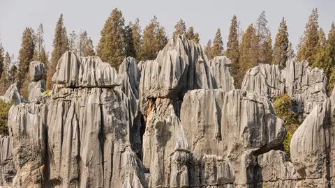
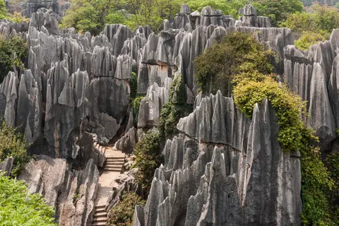
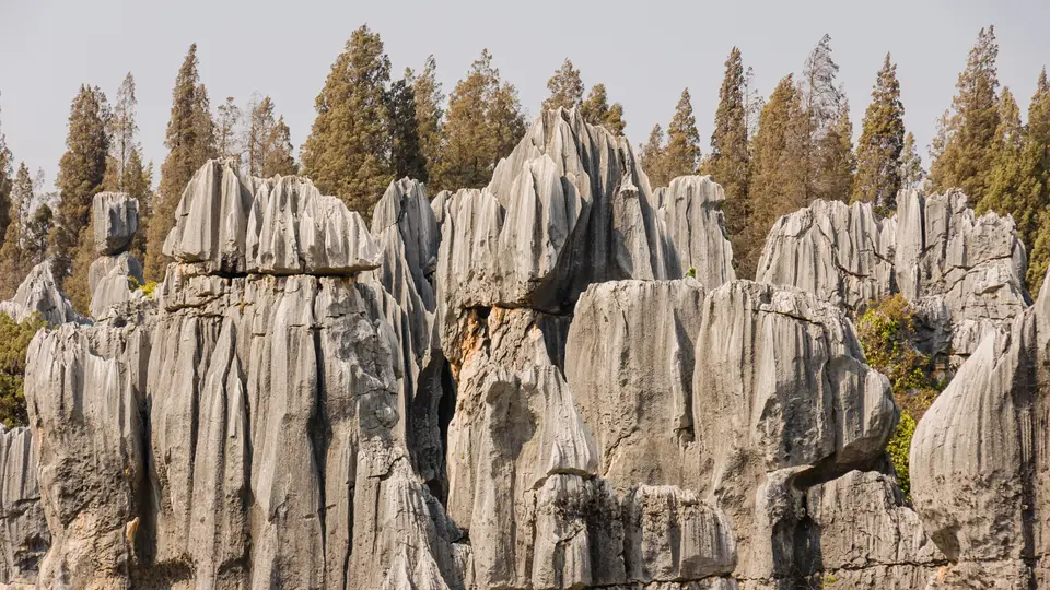
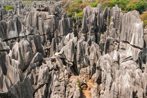
Understanding limestone karst geology across southern China reaches back 270 million years to the Early Permian epoch, when shallow tropical seas submerged the region. Thick marine beds of nearly pure limestone (Maokou Formation) and dolomitic limestone (Qixia Formation) accumulated over older Liangshan Formation sandstones and shales, aggregating 505 metres in thickness around Shilin. These massive platform carbonates range across bio-clastic limestone, calcarenite, and calcilutite, preserving microscopic whole or fractured fusulinid foraminifera together with discrete bands of chert nodules inside heavily altered rock. Tectonic uplift tilted strata into gentle 2-to-6-degree westward-dipping monoclines sliced by conjugate northeast-southwest and northeast-southeast shear joints. Impermeable Liangshan shales beneath acted as a permeability barrier forcing groundwater to migrate laterally from west to east along joints, carving steep vertical pillars across today's 400-to-500-square-kilometre stone forest through four major geological stages from Permian seas to the present.
Only 9 kilometres northeast of Greater and Lesser Stone Forests (Lizijing), the Naigu Stone Forest shows how mineral chemistry shapes rock silhouettes. Maokou limestones containing less than 3 percent dolomite weather into pale, razor-fluted spires, whereas Naigu's Permian Qixia beds carry abundant dolomite yielding darker, blockier pillars and Suyishan outcrops rising straight out of lake water. Lying 90 kilometres east of Kunming as a 5A scenic park, Shilin divides into seven distinct sightseeing zones. Visitors explore Greater and Lesser Stone Forests, Naigu, Zhiyun Cave, Qifeng Cave, Long Lake (Changhu), Moon Lake (Yuehu), and Dadieshui Waterfall, with Naigu and Suogeyi Village inscribed formally for World Heritage protection.
Further east across Guizhou and Guangxi, Libo Karst and adjoining Huanjiang Karst display textbook cone karst (fengcong) dotted with steep enclosed cockpits, sinking streams, and long underground river caves cutting carbonate outcrops of varied ages. Huanjiang lies inside Mulun National Nature Reserve (also a Man and Biosphere Reserve), preserving pristine monsoon forest over jagged peaks as a natural continuation of Libo's national nature reserve. Down in low-lying Lijiang National Park at Guilin, rainfed allogenic runoff pouring off surrounding sandstone hills fuels vigorous lateral river erosion, widening flat alluvial valley floors studded with freestanding pillars. Geomorphologists established the Guilin model specifically to explain how clustered fengcong cones and isolated fenglin towers evolve side by side across Guilin's basin, complementing coastal limestone cliffs south in Viet Nam.
Meanwhile, dolomite resistance and tectonic uplift diversify the remaining clusters. Inside Guizhou's Wuyanghe National Park, Shibing Karst displays mist-draped spine-like peaks, deep gorges, karren flutes, and tufa deposits carved into relatively insoluble dolomite rock. Up in Chongqing municipality, uplifted Wulong Karst preserves three core zones pierced by giant tiankeng collapse depressions, soaring natural stone bridges, and deep unroofed ancient caves recording early cutting by the Yangtze River system and its tributaries. Nearby Jinfoshan rises as an isolated karst table mountain long detached from the Yunnan-Guizhou-Chongqing plateau by deep river canyons, preserving an ancient planation surface and weathering crust above stranded horizontal cave passages high in cliff walls that trace episodic Cenozoic uplift.
Catchment Stewardship Across Seven Dispersed Clusters
Because fractured limestone channels surface runoff straight into underground caverns, preserving these karst mountains depends on protecting whole upstream and downstream watersheds beyond park boundaries. National parks, national nature reserves, and Shilin's UNESCO Global Geopark buffer zone regulate farming runoff, urban expansion, and tourism pressures across four provinces. An integrated Protection and Management Coordination Committee links provincial authorities and ethnic minority stewards to safeguard underground ecosystems and water quality from Yunnan's plateau east to Guangxi's river valleys. Maintaining forest vegetation cover across steep ridges stops surface erosion while sustaining seasonal shifts that draw visitors across four provinces.
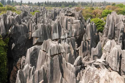
Examining this regional karst gradient as one unified system demonstrates how climate, water volume, and uplift speed transform identical marine carbonate beds into dramatically contrasting landforms. Up on the high western Yunnan-Guizhou plateau around Shilin, slow vertical rain infiltration along intersecting joint grids leaves dense forests of grey rock pillars standing shoulder to shoulder. Descending through Guizhou's Libo and Chongqing's Wulong, fast subterranean rivers carve huge collapse chambers, natural stone arches, and conical cockpits separated by forested valleys. Finally, at lower elevations across Guilin's basin, steady rainfed river flow sweeping off adjacent hills planes away broad floodplains until only isolated vertical limestone towers rise sharply out of level agricultural soil.
Each province's cluster contributes irreplaceable scientific evidence toward reconstructing this 700-kilometre descent. Shilin's buffer zone carries UNESCO Global Geopark status protecting Permian bedrock against urban expansion 90 kilometres east of Kunming, while Libo's national nature reserve safeguards deep underground streams. In Chongqing, Wulong's three core zones and Jinfoshan's National Nature Reserve reveal intermittent Cenozoic tectonic uplift above Yangtze River gorges, whereas Shibing's insoluble dolomite hills prove steep cone karst forms beyond pure limestone.
Botanical richness across these fractured slopes mirrors this geological diversity closely. Protected woodland pockets host Sino-Himalayan genera including Colquhounia, Prinsepia, and Corallodiscus, Sino-Japanese woodland plants such as Akebia and Sinomenium, and East Asian flora ranging from Ainsliaea and Codonopsis to Lycoris and Ophiopogon. Preserving water purity across upland lakes and subterranean river networks safeguards both surface plant communities and sensitive cave-dwelling wildlife across every season. Strict upstream and downstream catchment rules further ensure pollution from surrounding farming or urban growth never degrades delicate carbonate ecosystems across China's southern borderlands or neighbouring Southeast Asian karst basins. Together, all seven clusters illustrate continuous geological erosion from high plateau stone forests down to low flooded tower plains across southern China. Visitors comparing Yunnan's Permian stone columns with Guangxi's river towers experience an unmatched living textbook of tropical and subtropical limestone landforms across the South China Karst region.
Access Zones Across the Seven Karst Clusters
Because the seven clusters spread over 700 kilometres across four provinces, choosing two or three clusters allows rewarding comparisons of pinnacle, cone, tower, and gorge landscapes without exhausting transfers.
| Complex Zone | Key Highlights | Access & Ticket Rule |
|---|---|---|
| Shilin Stone Forest (Yunnan). | 270-million-year Permian limestone spires, Naigu dolomitic towers, Suogeyi Village, caves, and karst lakes. | Located 90 kilometres east of Kunming. Scenic park passes and internal electric shuttles govern entry. |
| Libo & Huanjiang (Guizhou, Guangxi). | Clustered fengcong cones, enclosed sinkhole cockpits, river caves, and Mulun monsoon forest. | Protected within national nature reserves. Regional park tickets manage boardwalk and cave trail capacity. |
| Guilin Karst (Guangxi). | Lijiang National Park Putao and Lijiang sections showing fenglin towers beside clustered fengcong cones. | Cruises, riverbank paths, and hilltop viewpoints follow municipal park ticketing in Guilin and Yangshuo. |
| Wulong & Jinfoshan (Chongqing). | Giant tiankeng collapse dolines, soaring stone bridges, unroofed Yangtze caves, and Jinfoshan table mountain. | Chongqing scenic gateways manage shuttle transport, walkway access passes, and daily crowd limits. |
| Shibing Dolomite Karst (Guizhou). | Cloud-draped dolomite ridges, narrow Wuyanghe gorges, fluted karren, and calcareous tufa cascades. | National park walkways follow seasonal daylight access rules with local eco-bus connections. |
Three Geological Features Across Southern China's Karst Terrain
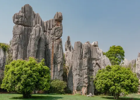
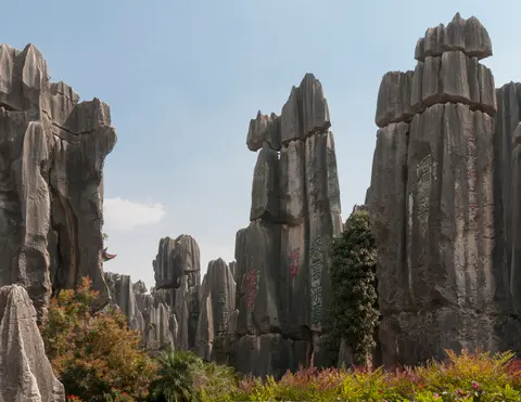
- Vertical Fluting and Joint Control at Shilin: Walk the narrow stone passages of Greater Stone Forest to trace deep vertical rain grooves running down grey Permian pillars. Pre-karst groundwater dissolved conjugate fractures beneath soil before plateau uplift exposed the 505-metre formation to monsoon downpours.
- Dolomitic Versus Pure Limestone Silhouettes: Compare needle-sharp Maokou limestone spires at Lizijing with darker, blockier Qixia dolomite towers 9 kilometres away at Naigu or across Shibing's ridges. Rock chemistry directly controls whether carbonate peaks sharpen into blades or block along joints.
- Side-by-Side Fengcong Cones and Fenglin Towers: Along Guilin's Lijiang valley, contrast tightly linked cone clusters sharing rocky pedestals against isolated vertical towers rising directly out of flooded valley plains.
Regional Gateway Strategy and Seasonal Timing
Picking a practical mainland gateway depends on which landform group tops your list. Travellers targeting Guizhou clusters arrive via Guiyang Longdongbao International Airport (KWE), 71 kilometres from the Libo-Guizhou hub zone, while Kaili Huangping Airport (KJH) at 60 kilometres handles limited regional flights. Yunnan explorers base in Kunming 90 kilometres west of Shilin, whereas Guilin and Chongqing clusters pair cleanly via high-speed rail and domestic flights.
Spring and autumn bring comfortable hiking air and drier limestone stairways across Wulong's sinkhole gorges and Guilin's riverbanks while softening summer monsoon rains. Allow three to four days per cluster rather than rushing across four provinces in one sweep, connect wider southern itineraries through Hong Kong (827 kilometres southeast), and explore more geological landscapes inside the UNESCO World Heritage Atlas.